
| LAWRENCE MUNI LAWRENCE MA |
| |
| Lat: N 4243.0 Long: W 07107.4 Elev: 148 Var: +15 Longest Runway: 5001 | ||
| Clr Del: 126.15 TWRCLD Dept. ATIS: 126.75 Arr. ATIS: 126.75 AWOS: 126.75 Ground: 124.3 Tower: 119.25 | ||
| ||||||||||||||||||||||||||||||||||||||||||||
| ||||||||||||||||||||||||||||||||||||||||||||
| ||||||||||||||||||||||||||||||||||||||||||||
| ||||||||||||||||||||||||||||||||||||||||||||
| ||||||||||||||||||||||||||||||||||||||||||||
| ||||||||||||||||||||||||||||||||||||||||||||
| Rwy | Rwy | |||||||
| 5001x100 | 5001' | 111.70 - 053° | 5001x100 | 5001' | ||||
| 3654x100 | 3654' | 3654x100 | 3574' | |||||
| Runway ID | Single Wheel | Double Wheel | Double Tandem Wheel | Dual Double Wheel |
| 05/23 | 45,000 | 62,000 | 110,000 | N/A |
| 14/32 | 30,000 | 34,000 | 53,000 | N/A |
| These numbers are Advisory and are not limits. The Airport Manager should have more accurate Weight Limits | ||||
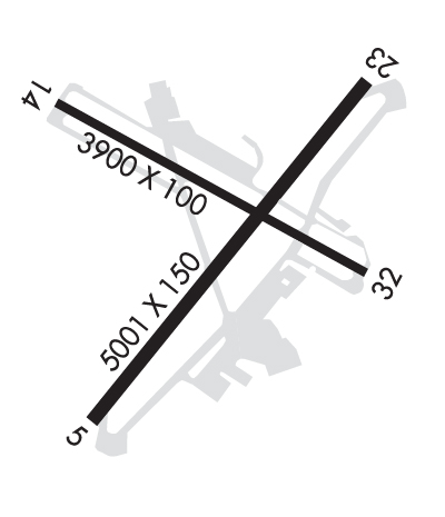 Airport Diagram might not be current. | |
| Facility Name: | LAWRENCE MUNI |
| City Name: | LAWRENCE |
| County: | ESSEX |
| State abbrev: | MA |
| State Name: | MASSACHUSETTS |
| Ownership: | PUBLICLY OWNED |
| Use: | OPEN TO THE PUBLIC |
| Owner's Name: | CITY OF LAWRENCE |
| Address: | CITY HALL, 200 COMMON ST |
| LAWRENCE, MA 08140 | |
| Owner's Phone: | 978-620-3014 |
| Manager's Name: | FRANCISCO A. URENA |
| Address: | 492 SUTTON ST |
| NO. ANDOVER, MA 01845 | |
| Phone: | 978-794-5880 |
| FAA Region: | NEW ENGLAND |
| FAA Field Office: | NONE |
| Date | Sunrise | Sunset |
|---|---|---|
| 12/10/25 Wednesday | 7:04 | 16:11 |
| 12/11/25 Thursday | 7:05 | 16:11 |
| 12/12/25 Friday | 7:05 | 16:11 |
| 12/13/25 Saturday | 7:06 | 16:11 |
| 12/14/25 Sunday | 7:07 | 16:11 |
| 12/15/25 Monday | 7:08 | 16:11 |
| 12/16/25 Tuesday | 7:08 | 16:12 |
| 12/17/25 Wednesday | 7:09 | 16:12 |
| 12/18/25 Thursday | 7:10 | 16:12 |
| 12/19/25 Friday | 7:10 | 16:13 |
| 12/20/25 Saturday | 7:11 | 16:13 |
| 12/21/25 Sunday | 7:11 | 16:14 |
| 12/22/25 Monday | 7:12 | 16:14 |
| 12/23/25 Tuesday | 7:12 | 16:15 |
| Airport Attendance Schedule | 7 Days A Week 0700-2200 |
| Airport Status | OPERATIONAL (This Status can change at any time - please check NOTAMS) |
| Airport Lighting Schedule | ACTVT REIL RWY 05, 23, 14 & 32; PAPI RWY 05, 23 & 32; HIRL RWY 05/23; MIRL RWY 14/32 - CTAF. |
| Airport Storage Available | Tie Downs, Hanger |
| Extra Services Available | Air Ambulance, Cargo Handling, Flight Instruction, Aircraft Rental, Aircraft Sales, Annual Surveying |
| Wind Indicator | YES - (unlit) |
| Control Tower | YES |
| CTAF Frequency | 119.250 |
| Unicom Frequency | 122.800 |
| Rotating Beacon Color | WG |
| Segmented Circle | NO |
| Landing Fee | YES; LNDG FEE FOR ACFT REGISTERED TO CORPORATION ONLY. |
| Airport Inspected | STATE - performed by STATE AERONAUTICAL PERSONNEL |
| Inspection Date | 11/21/2023 |
| Type of Fuel Available | Grade 100LL, JET A (freeze point -40C), JET A |
| Airframe Repair Service | MAJOR |
| Power Plant Repair Service | MAJOR |
| Latitude | N4243.0 |
| Longitude | W07107.4 (ESTIMATED) |
| Arpt Elevation | 147ft (SURVEYED) |
| Magnetic Variation | 15W |
| 2 miles E | of LAWRENCE |
| Traffic Pattern Altitude | |
| Sectional Chart | NEW YORK |
| Operations (Reported) | Yearly | Avg. Daily |
|---|---|---|
| General Aviation Transient | 0 | 0 |
| General Aviation Local | 0 | 0 |
| Air Taxi | 0 | 0 |
| Commerical | 0 | 0 |
| Commuter | 0 | 0 |
| Military | 0 | 0 |
| Aircraft based on Field | |
|---|---|
| General Aviation Singles | 0 |
| General Aviation Multi | 0 |
| Jet Aircraft | 0 |
| General Aviation Helicopters | 0 |
| Military Aircraft | 0 |
| Gliders | 0 |
| Ultralights | 0 |
| FSS on field | NO |
| FSS tie-in | BRIDGEPORT |
| FSS Phone | 1-800-WX-BRIEF |
| Who issues Notams | LWM |
| Notam D service at airport | YES |
| ARTCC Name | BOSTON |
| Airport Certification | |
| Aircraft Rescue & Firefighting Index | None |
| Airport of Entry | No |
| Custom Landing Rights | YES |
| Joint Civil/Military | No |
| Military Landing rights | YES |
| NATIONAL PLAN OF INTEGRATED AIRPORT SYSTEMS (NPIAS) |
| GRANT AGREEMENTS UNDER FAAP/ADAP/AIP |
| ASSURANCES PURSUANT TO TITLE VI, CIVIL RIGHTS ACT OF 1964 |
| AGREEMENT UNDER DLAND OR DCLA HAS EXPIRED. |
| HILL 5400 FT SE & STANDPIPE 7200 FT NE; LGTD. |
| WILDLIFE ON & INVOF ARPT. |
| LGTD STACK 296 FT MSL 1/2 MI NW AER 23. |
| CLSD TFC PAT, INITIATE TURN-OUT AT 700 FT AGL. |
| USE RSNBL EFFORTS TO MNTN MANUFACTURER'S RCMDD BEST ROC. |
Airport Communications & Frequencies:
| ||||||||||||||||||||||||
| Runway: 05 | Runway: 23 | ||
| Mag heading: | 53° | Mag heading: | 233° |
| Rwy Slope: | -.01% Down | Rwy Slope: | .01% Up |
| Approach: | ILS | Approach: | |
| Pattern: | Left Traffic | Pattern: | Left Traffic |
| Markings: | PRECISION INSTRUMENT | Markings: | PRECISION INSTRUMENT |
| Marking Condition: | GOOD | Marking Condition: | GOOD |
| Arresting Dev: | Arresting Dev: | ||
| Lat & Long: | N4242.6 W07107.7 | Lat. & Long.: | N4243.3 W07107.1 |
| Elev: | 134.7 ft. MSL | Elev: | 134.1 ft. MSL |
| TCH: | 55 ft. AGL | TCH: | 55 ft. AGL |
| Visual Glide Path: | 3.00 degrees | Visual Glide Path: | 3.70 degrees |
| Displaced Threshold: | No | Displaced Threshold: | No |
| Touchdown Zone: | YES | Touchdown Zone: | YES |
| Touchdown Elev.: | 143.8 feet | Touchdown Elev.: | 143.8 feet |
| Visual Glide Slope: | 4-Light PAPI on RIGHT side of Runway | Visual Glide Slope: | 4-Light PAPI on LEFT side of Runway |
| RVR Equipment: | RVR Equipment: | ||
| RVV Equipment: | NO | RVV Equipment: | NO |
| Approach Lights: | Approach Lights: | ||
| REIL: | YES | REIL: | YES |
| Centerline Lights: | NO | Centerline Lights: | NO |
| Touchdown lights: | NO | Touchdown lights: | NO |
| Runway Category: | Precision Instrument Runway | Runway Category: | Runway with a Non-precision Approach having visibility minimums greater than 3/4 mile |
| Declared Distances: | Declared Distances: | ||
| Obstructions: | Obstructions: | TREES | |
| Marked: | Marked: | NOT Marked/Lighted | |
| Clearance slope: | 50:1 | Clearance slope: | 34:1 |
| Obstruction height: | Obstruction height: | 13 feet AGL | |
| Dist. from runway: | Dist. from runway: | 650 feet | |
| Centerline offset: | Centerline offset: | ||
| Comments: | Comments: |
| Runway: 14 | Runway: 32 | ||
| Mag heading: | 137° | Mag heading: | 317° |
| Rwy Slope: | .71% Up | Rwy Slope: | -.71% Down |
| Approach: | Approach: | ||
| Pattern: | Left Traffic | Pattern: | Left Traffic |
| Markings: | BASIC | Markings: | BASIC |
| Marking Condition: | GOOD | Marking Condition: | GOOD |
| Arresting Dev: | Arresting Dev: | ||
| Lat & Long: | N4243.3 W07107.8 | Lat. & Long.: | N4242.9 W07107.1 |
| Elev: | 121.5 ft. MSL | Elev: | 147.6 ft. MSL |
| TCH: | TCH: | 32 ft. AGL | |
| Visual Glide Path: | Visual Glide Path: | 4.00 degrees | |
| Displaced Threshold: | No | Displaced Threshold: | 80 feet |
| Touchdown Zone: | YES | Touchdown Zone: | YES |
| Touchdown Elev.: | 145.9 feet | Touchdown Elev.: | 147.4 feet |
| Visual Glide Slope: | Visual Glide Slope: | 4-Light PAPI on LEFT side of Runway | |
| RVR Equipment: | RVR Equipment: | ||
| RVV Equipment: | NO | RVV Equipment: | NO |
| Approach Lights: | Approach Lights: | ||
| REIL: | YES | REIL: | YES |
| Centerline Lights: | NO | Centerline Lights: | NO |
| Touchdown lights: | NO | Touchdown lights: | NO |
| Runway Category: | Runway with a Visual Approach | Runway Category: | Runway with a Visual Approach |
| Declared Distances: | Declared Distances: | ||
| Obstructions: | Obstructions: | TREES | |
| Marked: | Marked: | NOT Marked/Lighted | |
| Clearance slope: | 50:1 | Clearance slope: | 14:1; APCH RATIO 50:1 TO DTHR. |
| Obstruction height: | Obstruction height: | 7 feet AGL | |
| Dist. from runway: | Dist. from runway: | 300 feet | |
| Centerline offset: | Centerline offset: | 125 feet left of centerline | |
| Comments: | Comments: |
Thanks for using FltPlan.com
all rights reserved © 1999-2025 by Flight Plan LLC