| LAREDO INTL LAREDO TX |
| |
| Lat: N 2732.7 Long: W 09927.7 Elev: 508 Var: -05 Longest Runway: 8743 | ||
| Dept. ATIS: 125.77 Arr. ATIS: 125.77 AWOS: 125.77 Ground: 121.8 Tower: 120.1 | ||
| ||||||||||||||||||||||||||||||||||||||||||||||||||||||||||||||||||||
| ||||||||||||||||||||||||||||||||||||||||||||||||||||||||||||||||||||
| ||||||||||||||||||||||||||||||||||||||||||||||||||||||||||||||||||||
| ||||||||||||||||||||||||||||||||||||||||||||||||||||||||||||||||||||
| ||||||||||||||||||||||||||||||||||||||||||||||||||||||||||||||||||||
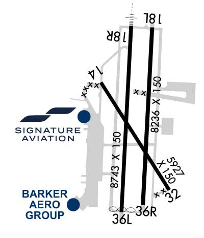
| Rwy | Rwy | |||||||
| 5927x150 | 5927' | 5927x150 | 5927' | |||||
| 8236x150 | 8236' | 8236x150 | 8236' | |||||
| 8743x150 | 8743' | 111.90 - 177° | 8743x150 | 8623' | ||||
| Runway ID | Single Wheel | Double Wheel | Double Tandem Wheel | Dual Double Wheel |
| 14/32 | 50,000 | 60,000 | 125,000 | N/A |
| 18L/36R | 90,000 | 190,000 | 360,000 | N/A |
| 18R/36L | 90,000 | 190,000 | 415,000 | 820,000 |
| These numbers are Advisory and are not limits. The Airport Manager should have more accurate Weight Limits | ||||
 Airport Diagram might not be current. | |
| Facility Name: | LAREDO INTL |
| City Name: | LAREDO |
| County: | WEBB |
| State abbrev: | TX |
| State Name: | TEXAS |
| Ownership: | PUBLICLY OWNED |
| Use: | OPEN TO THE PUBLIC |
| Owner's Name: | CITY OF LAREDO |
| Address: | PO BOX 579 |
| LAREDO, TX 78041 | |
| Owner's Phone: | 956-791-7300 |
| Manager's Name: | JEFF MILLER |
| Address: | 5210 BOB BULLOCK LOOP |
| LAREDO, TX 78041 | |
| Phone: | 956-795-2000 |
| FAA Region: | SOUTHWEST |
| FAA Field Office: | TEX |
| Date | Sunrise | Sunset |
|---|---|---|
| 09/24/21 Friday | 7:27 | 19:32 |
| 09/25/21 Saturday | 7:28 | 19:31 |
| 09/26/21 Sunday | 7:28 | 19:30 |
| 09/27/21 Monday | 7:29 | 19:29 |
| 09/28/21 Tuesday | 7:29 | 19:28 |
| 09/29/21 Wednesday | 7:29 | 19:26 |
| 09/30/21 Thursday | 7:30 | 19:25 |
| 10/01/21 Friday | 7:30 | 19:24 |
| 10/02/21 Saturday | 7:31 | 19:23 |
| 10/03/21 Sunday | 7:31 | 19:22 |
| 10/04/21 Monday | 7:32 | 19:21 |
| 10/05/21 Tuesday | 7:32 | 19:20 |
| 10/06/21 Wednesday | 7:33 | 19:19 |
| 10/07/21 Thursday | 7:33 | 19:18 |
| Airport Attendance Schedule | CONTINUOUS |
| Airport Status | OPERATIONAL (This Status can change at any time - please check NOTAMS) |
| Airport Lighting Schedule | WHEN ATCT CLSD ACTVT MALSR RWY 18R - CTAF. MIRL RWY 14/32; HIRL RWYS 18L/36R & 18R/36L PRESET MED INTST. |
| Airport Storage Available | Tie Downs, Hanger |
| Extra Services Available | Air Freight, Avionics, Cargo Handling, Charter, Flight Instruction, Aircraft Rental, Aircraft Sales |
| Wind Indicator | YES - (lighted) |
| Control Tower | YES |
| CTAF Frequency | 120.100 |
| Unicom Frequency | 122.950 |
| Rotating Beacon Color | CLEAR-GREEN (Light Land Airport) |
| Segmented Circle | YES |
| Landing Fee | NO |
| Airport Inspected | FEDERAL - performed by FAA AIRPORTS FIELD PERSONNEL |
| Inspection Date | 12/10/2019 |
| Type of Fuel Available | Grade 100LL, JET A (freeze point -40C); -10JP4 FUEL AVBL. |
| Airframe Repair Service | None |
| Power Plant Repair Service | MAJOR |
| Latitude | N2732.7 |
| Longitude | W09927.7 (ESTIMATED) |
| Arpt Elevation | 508ft (SURVEYED) |
| Magnetic Variation | 05E |
| 3 miles NE | of LAREDO |
| Traffic Pattern Altitude | |
| Sectional Chart | BROWNSVILLE |
| Operations (Reported) | Yearly | Avg. Daily |
|---|---|---|
| General Aviation Transient | 19425 | 53 |
| General Aviation Local | 10509 | 29 |
| Air Taxi | 7941 | 22 |
| Commerical | 6689 | 18 |
| Commuter | 0 | 0 |
| Military | 34723 | 95 |
| Aircraft based on Field | |
|---|---|
| General Aviation Singles | 31 |
| General Aviation Multi | 9 |
| Jet Aircraft | 30 |
| General Aviation Helicopters | 13 |
| Military Aircraft | 8 |
| Gliders | 0 |
| Ultralights | 0 |
| FSS on field | NO |
| FSS tie-in | SAN ANGELO |
| FSS Phone | 1-800-WX-BRIEF |
| Who issues Notams | LRD |
| Notam D service at airport | YES |
| ARTCC Name | HOUSTON |
| Airport Certification | AIRPORT RECEIVING SCHEDULED AIR CARRIER SERVICE FROM CARRIERS CERTIFICATED BY THE CIVIL AERONAUTICS BOARD |
| Aircraft Rescue & Firefighting Index | AIRPORT HAS A CERTIFICATE UNDER CFR PART 139 |
| Airport of Entry | YES |
| Custom Landing Rights | YES |
| Joint Civil/Military | No |
| Military Landing rights | YES |
| NATIONAL PLAN OF INTEGRATED AIRPORT SYSTEMS (NPIAS) |
| GRANT AGREEMENTS UNDER FAAP/ADAP/AIP |
| SURPLUS PROPERTY AGREEMENT UNDER PUBLIC LAW 289 |
| ASSURANCES PURSUANT TO TITLE VI, CIVIL RIGHTS ACT OF 1964 |
| FEDERAL INSPECTION STATION IS LCTD ON THE WEST GENERAL AVIATION/CARGO APRON. |
| FOR CD IF UNA TO CTC ON FSS FREQ, CTC HOUSTON ARTCC AT 281-230-5622. |
| BIRDS ON AND INVOF ARPT. |
| LNDG FEE ASSESSED FOR ANY "FOR HIRE" ACFT. |
| FEDERAL INSPECTION STATION FEE. |
| RWY 14/32 RSTRD TO ACFT LESS THAN 60000 LBS DTW. |
| TWY C CLSD BTN RWY 18L/36R & RWY 18R INDEFLY. |
Airport Communications & Frequencies:
| |||||||||||||||||||
| Runway: 14 | Runway: 32 | ||
| Mag heading: | 142° | Mag heading: | 322° |
| Rwy Slope: | -.64% Down | Rwy Slope: | .64% Up |
| Approach: | Approach: | ||
| Pattern: | Left Traffic | Pattern: | Right Traffic |
| Markings: | NONPRECISION INSTRUMENT | Markings: | NONPRECISION INSTRUMENT |
| Marking Condition: | GOOD | Marking Condition: | GOOD |
| Arresting Dev: | Arresting Dev: | ||
| Lat & Long: | N2733.0 W09928.0 | Lat. & Long.: | N2732.1 W09927.4 |
| Elev: | 505.4 ft. MSL | Elev: | 467.4 ft. MSL |
| TCH: | 55 ft. AGL | TCH: | 71 ft. AGL |
| Visual Glide Path: | 3.00 degrees | Visual Glide Path: | 3.00 degrees |
| Displaced Threshold: | No | Displaced Threshold: | No |
| Touchdown Zone: | YES | Touchdown Zone: | YES |
| Touchdown Elev.: | 508.0 feet | Touchdown Elev.: | 493.6 feet |
| Visual Glide Slope: | 4-BOX VASI ON LEFT SIDE OF RUNWAY | Visual Glide Slope: | 4-BOX VASI ON LEFT SIDE OF RUNWAY |
| RVR Equipment: | RVR Equipment: | ||
| RVV Equipment: | NO | RVV Equipment: | NO |
| Approach Lights: | Approach Lights: | ||
| REIL: | NO | REIL: | NO |
| Centerline Lights: | NO | Centerline Lights: | NO |
| Touchdown lights: | NO | Touchdown lights: | NO |
| Runway Category: | Runway with a Non-precision Approach having visibility minimums greater than 3/4 mile | Runway Category: | Runway with a Non-precision Approach having visibility minimums greater than 3/4 mile |
| Declared Distances: | TORA:5927' TODA:5927' ASDA:5927' LDA:5927' | Declared Distances: | TORA:5927' TODA:5927' ASDA:5927' LDA:5927' |
| Obstructions: | Obstructions: | ROAD | |
| Marked: | Marked: | NOT Marked/Lighted | |
| Clearance slope: | 50:1 | Clearance slope: | |
| Obstruction height: | Obstruction height: | 12 feet AGL | |
| Dist. from runway: | Dist. from runway: | 201 feet | |
| Centerline offset: | Centerline offset: | 250 feet right of centerline | |
| Comments: | Comments: |
| Runway: 18L | Runway: 36R | ||
| Mag heading: | 178° | Mag heading: | 358° |
| Rwy Slope: | -.30% Down | Rwy Slope: | .30% Up |
| Approach: | Approach: | ||
| Pattern: | Left Traffic | Pattern: | Right Traffic |
| Markings: | NONPRECISION INSTRUMENT | Markings: | NONPRECISION INSTRUMENT |
| Marking Condition: | GOOD | Marking Condition: | GOOD |
| Arresting Dev: | Arresting Dev: | ||
| Lat & Long: | N2733.4 W09927.6 | Lat. & Long.: | N2732.0 W09927.6 |
| Elev: | 499.2 ft. MSL | Elev: | 474.2 ft. MSL |
| TCH: | 51 ft. AGL | TCH: | |
| Visual Glide Path: | 3.00 degrees | Visual Glide Path: | |
| Displaced Threshold: | No | Displaced Threshold: | No |
| Touchdown Zone: | YES | Touchdown Zone: | YES |
| Touchdown Elev.: | 499.2 feet | Touchdown Elev.: | 486.7 feet |
| Visual Glide Slope: | 4-Light PAPI on LEFT side of Runway | Visual Glide Slope: | |
| RVR Equipment: | RVR Equipment: | ||
| RVV Equipment: | NO | RVV Equipment: | NO |
| Approach Lights: | Approach Lights: | ||
| REIL: | NO | REIL: | NO |
| Centerline Lights: | NO | Centerline Lights: | NO |
| Touchdown lights: | NO | Touchdown lights: | NO |
| Runway Category: | Runway with a Non-precision Approach having visibility minimums greater than 3/4 mile | Runway Category: | Runway with a Visual Approach |
| Declared Distances: | TORA:8236' TODA:8236' ASDA:8236' LDA:8236' | Declared Distances: | TORA:8236' TODA:8236' ASDA:8236' LDA:8236' |
| Runway: 18R | Runway: 36L | ||
| Mag heading: | 178° | Mag heading: | 358° |
| Rwy Slope: | -.23% Down | Rwy Slope: | .23% Up |
| Approach: | ILS/DME | Approach: | |
| Pattern: | Left Traffic | Pattern: | Right Traffic |
| Markings: | PRECISION INSTRUMENT | Markings: | PRECISION INSTRUMENT |
| Marking Condition: | GOOD | Marking Condition: | GOOD |
| Arresting Dev: | EMAS; ENGINEERED MATERIALS ARRESTING SYSTEM (EMAS) 363 FT IN LENGTH BY 170 FT IN WIDTH LCTD AT THE DER 18R. | Arresting Dev: | |
| Lat & Long: | N2733.4 W09927.7 | Lat. & Long.: | N2731.9 W09927.8 |
| Elev: | 503.7 ft. MSL | Elev: | 483.7 ft. MSL |
| TCH: | 50 ft. AGL | TCH: | 50 ft. AGL |
| Visual Glide Path: | 3.00 degrees | Visual Glide Path: | 3.00 degrees |
| Displaced Threshold: | No | Displaced Threshold: | 120 feet |
| Touchdown Zone: | YES | Touchdown Zone: | YES |
| Touchdown Elev.: | 503.7 feet | Touchdown Elev.: | 497.0 feet |
| Visual Glide Slope: | 4-Light PAPI on LEFT side of Runway | Visual Glide Slope: | 4-Light PAPI on LEFT side of Runway |
| RVR Equipment: | RVR Equipment: | ||
| RVV Equipment: | NO | RVV Equipment: | NO |
| Approach Lights: | MALSR - 1,400 foot medium intensity approach lighting system with runway alignment indicator lights | Approach Lights: | |
| REIL: | NO | REIL: | NO |
| Centerline Lights: | NO | Centerline Lights: | NO |
| Touchdown lights: | NO | Touchdown lights: | NO |
| Runway Category: | Precision Instrument Runway | Runway Category: | Runway with a Non-precision Approach having visibility minimums greater than 3/4 mile |
| Declared Distances: | TORA:8743' TODA:8743' ASDA:8743' LDA:8743' | Declared Distances: | TORA:8743' TODA:8743' ASDA:8743' LDA:8623' |
Thanks for using FltPlan.com
all rights reserved © 1999-2021 by Flight Plan LLC