
| KINGS LAND O' LAKES LAND O' LAKES WI |
| |
| Lat: N 4609.2 Long: W 08912.7 Elev: 1706 Var: +02 Longest Runway: 4000 | ||
| Clr Del: 121.72 (GCO) AWOS: 119.52 CTAF: 122.8 | ||
| ||||||||||||||||||||||||||||||||||||||||||||
| ||||||||||||||||||||||||||||||||||||||||||||
| ||||||||||||||||||||||||||||||||||||||||||||
| Rwy | Rwy | |||||||
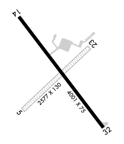
| 2577x130 | 2577' | 2577x130 | 1988' | |||||
| 4000x75 | 3799' | 4000x75 | 3601' | |||||
| Runway ID | Single Wheel | Double Wheel | Double Tandem Wheel | Dual Double Wheel |
| 05/23 | N/A | N/A | N/A | N/A |
| 14/32 | 12,000 | N/A | N/A | N/A |
| These numbers are Advisory and are not limits. The Airport Manager should have more accurate Weight Limits | ||||
 Airport Diagram might not be current. | |
| Facility Name: | KINGS LAND O' LAKES |
| City Name: | LAND O' LAKES |
| County: | VILAS |
| State abbrev: | WI |
| State Name: | WISCONSIN |
| Ownership: | PUBLICLY OWNED |
| Use: | OPEN TO THE PUBLIC |
| Owner's Name: | TOWN OF LAND O'LAKES |
| Address: | BOX 660 |
| LAND O'LAKES, WI 54540 | |
| Owner's Phone: | 715-547-3255 |
| Manager's Name: | BRUCE GARRISON |
| Address: | PO BOX 327 |
| LAND O'LAKES, WI 54540 | |
| Phone: | 715-547-3337 |
| FAA Region: | GREAT LAKES |
| FAA Field Office: | CHI |
| Date | Sunrise | Sunset |
|---|---|---|
| 04/21/26 Tuesday | 6:00 | 19:52 |
| 04/22/26 Wednesday | 5:58 | 19:53 |
| 04/23/26 Thursday | 5:57 | 19:54 |
| 04/24/26 Friday | 5:55 | 19:56 |
| 04/25/26 Saturday | 5:53 | 19:57 |
| 04/26/26 Sunday | 5:52 | 19:58 |
| 04/27/26 Monday | 5:50 | 20:00 |
| 04/28/26 Tuesday | 5:48 | 20:01 |
| 04/29/26 Wednesday | 5:47 | 20:02 |
| 04/30/26 Thursday | 5:45 | 20:04 |
| 05/01/26 Friday | 5:44 | 20:05 |
| 05/02/26 Saturday | 5:42 | 20:06 |
| 05/03/26 Sunday | 5:41 | 20:08 |
| 05/04/26 Monday | 5:39 | 20:09 |
| Airport Attendance Schedule | TUES-SAT 0700-1600 |
| Airport Status | OPERATIONAL (This Status can change at any time - please check NOTAMS) |
| Airport Lighting Schedule | ACTVT REIL RWY 14 & 32; PAPI RWY 14 & 32; MIRL RWY 14/32 - CTAF. SS-SR MIRL RWY 14/32 PRESET TO LOW INTST; INCR INTST - CTAF. |
| Airport Storage Available | Tie Downs, Hanger |
| Extra Services Available | NONE |
| Wind Indicator | YES - (lighted) |
| Control Tower | NO |
| CTAF Frequency | 122.800 |
| Unicom Frequency | 122.800 |
| Rotating Beacon Color | WG |
| Segmented Circle | YES |
| Landing Fee | NO |
| Airport Inspected | STATE - performed by STATE AERONAUTICAL PERSONNEL |
| Inspection Date | 07/30/2025 |
| Type of Fuel Available | Grade 100LLMOGAS; -10SELF SVC H24 WITH CREDIT CARD. |
| Airframe Repair Service | NONE |
| Power Plant Repair Service | NONE |
| Latitude | N4609.2 |
| Longitude | W08912.7 (ESTIMATED) |
| Arpt Elevation | 1705ft (SURVEYED) |
| Magnetic Variation | 02W |
| 1 miles SE | of LAND O' LAKES |
| Traffic Pattern Altitude | |
| Sectional Chart | GREEN BAY |
| Operations (Reported) | Yearly | Avg. Daily |
|---|---|---|
| General Aviation Transient | 0 | 0 |
| General Aviation Local | 0 | 0 |
| Air Taxi | 0 | 0 |
| Commerical | 0 | 0 |
| Commuter | 0 | 0 |
| Military | 0 | 0 |
| Aircraft based on Field | |
|---|---|
| General Aviation Singles | 0 |
| General Aviation Multi | 0 |
| Jet Aircraft | 0 |
| General Aviation Helicopters | 0 |
| Military Aircraft | 0 |
| Gliders | 0 |
| Ultralights | 0 |
| FSS on field | NO |
| FSS tie-in | GREEN BAY |
| FSS Phone | 1-800-WX-BRIEF |
| Who issues Notams | LNL |
| Notam D service at airport | YES |
| ARTCC Name | MINNEAPOLIS |
| Airport Certification | |
| Aircraft Rescue & Firefighting Index | None |
| Airport of Entry | No |
| Custom Landing Rights | No |
| Joint Civil/Military | No |
| Military Landing rights | No |
| NATIONAL PLAN OF INTEGRATED AIRPORT SYSTEMS (NPIAS) |
| DEER ON & INVOF ARPT. |
| FOR CD CTC MINNEAPOLIS ARTCC AT 651-463-5588. |
| RWY 05/2 3 CLSD NOV 15 - APR 15. |
| RWY 14 APCH RATIO 20:1 TO DTHR. |
Airport Communications & Frequencies:
| |||||||||
| Runway: 05 | Runway: 23 | ||
| Mag heading: | 52° | Mag heading: | 232° |
| Rwy Slope: | .29% Up | Rwy Slope: | -.29% Down |
| Approach: | Approach: | ||
| Pattern: | Left Traffic | Pattern: | Left Traffic |
| Markings: | Markings: | ||
| Marking Condition: | YELLOW CONES. | Marking Condition: | YELLOW CONES. |
| Arresting Dev: | Arresting Dev: | ||
| Lat & Long: | N4609.1 W08913.0 | Lat. & Long.: | N4609.4 W08912.5 |
| Elev: | 1696.8 ft. MSL | Elev: | 1704.4 ft. MSL |
| TCH: | TCH: | ||
| Visual Glide Path: | Visual Glide Path: | ||
| Displaced Threshold: | No | Displaced Threshold: | 589 feet |
| Touchdown Zone: | YES | Touchdown Zone: | YES |
| Touchdown Elev.: | 1705.0 feet | Touchdown Elev.: | 1703.0 feet |
| Visual Glide Slope: | Visual Glide Slope: | ||
| RVR Equipment: | RVR Equipment: | ||
| RVV Equipment: | NO | RVV Equipment: | NO |
| Approach Lights: | Approach Lights: | ||
| REIL: | NO | REIL: | NO |
| Centerline Lights: | NO | Centerline Lights: | NO |
| Touchdown lights: | NO | Touchdown lights: | NO |
| Runway Category: | Runway with a Visual Approach | Runway Category: | Runway with a Visual Approach |
| Declared Distances: | Declared Distances: | ||
| Obstructions: | TREES | Obstructions: | TREES |
| Marked: | NOT Marked/Lighted | Marked: | NOT Marked/Lighted |
| Clearance slope: | CTL OBSTN EXCEEDS 45 DEG SLOPE. | Clearance slope: | 5:1; APCH RATIO 16:1 TO DTHR; 94 FT TREES 1490 FT FM DTHR 135 L. |
| Obstruction height: | 34 feet AGL | Obstruction height: | 53 feet AGL |
| Dist. from runway: | 0 feet | Dist. from runway: | 285 feet |
| Centerline offset: | 100 right of centerline | Centerline offset: | 120 feet left of centerline |
| Comments: | Comments: |
| Runway: 14 | Runway: 32 | ||
| Mag heading: | 145° | Mag heading: | 325° |
| Rwy Slope: | -.04% Down | Rwy Slope: | .04% Up |
| Approach: | Approach: | ||
| Pattern: | Left Traffic | Pattern: | Left Traffic |
| Markings: | NONPRECISION INSTRUMENT | Markings: | NONPRECISION INSTRUMENT |
| Marking Condition: | GOOD | Marking Condition: | GOOD |
| Arresting Dev: | Arresting Dev: | ||
| Lat & Long: | N4609.5 W08913.0 | Lat. & Long.: | N4609.0 W08912.4 |
| Elev: | 1705.6 ft. MSL | Elev: | 1704.1 ft. MSL |
| TCH: | 40 ft. AGL | TCH: | 40 ft. AGL |
| Visual Glide Path: | 4.00 degrees | Visual Glide Path: | 3.00 degrees |
| Displaced Threshold: | 201 feet | Displaced Threshold: | 399 feet |
| Touchdown Zone: | YES | Touchdown Zone: | YES |
| Touchdown Elev.: | 1705.3 feet | Touchdown Elev.: | 1704.6 feet |
| Visual Glide Slope: | 2-Light PAPI on LEFT side of Runway | Visual Glide Slope: | 2-Light PAPI on LEFT side of Runway |
| RVR Equipment: | RVR Equipment: | ||
| RVV Equipment: | NO | RVV Equipment: | NO |
| Approach Lights: | Approach Lights: | ||
| REIL: | YES | REIL: | YES |
| Centerline Lights: | NO | Centerline Lights: | NO |
| Touchdown lights: | NO | Touchdown lights: | NO |
| Runway Category: | Runway with a Non-precision Approach | Runway Category: | Runway with a Non-precision Approach |
| Declared Distances: | Declared Distances: | ||
| Obstructions: | ROAD | Obstructions: | ROAD |
| Marked: | NOT Marked/Lighted | Marked: | LIGHTED |
| Clearance slope: | 1:1; APCH RATIO 20:1 TO DTHR. | Clearance slope: | 1:1 |
| Obstruction height: | 15 feet AGL | Obstruction height: | 18 feet AGL |
| Dist. from runway: | 200 feet | Dist. from runway: | 200 feet |
| Centerline offset: | 50 left of centerline | Centerline offset: | 245 feet right of centerline |
| Comments: | INTMT USE ROAD 0-200 FT FM RWY END 50-100 FT L. | Comments: | ROAD 187 FT FM RWY END 250 FT R. |
Thanks for using FltPlan.com
all rights reserved © 1999-2026 by Flight Plan LLC
