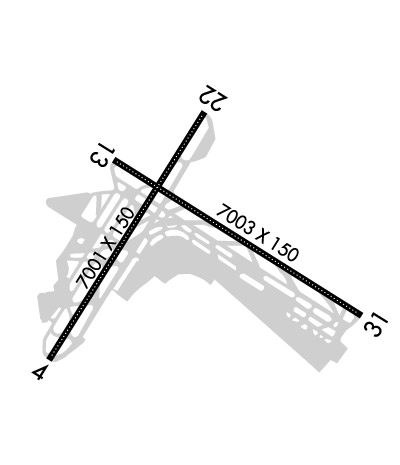
| LA GUARDIA NEW YORK NY |
| |
| Lat: N 4046.6 Long: W 07352.4 Elev: 21 Var: +12 Longest Runway: 7002 | ||
| Clr Del: 135.2 Dept. ATIS: 127.05 Arr. ATIS: 125.95  Ground: 121.7/121.85 Tower: 118.7 | ||
| ||||||
| ||||||
| ||||||
|
| Rwy | Rwy | |||||||
| 7002x150 | 7002' | 110.50 - 044° | 7002x150 | 7002' | 110.50 - 224° | |||
| 7002x150 | 7002' | 108.50 - 134° | 7002x150 | 7002' | 108.50 - 316° | |||
| Runway ID | Single Wheel | Double Wheel | Double Tandem Wheel | Dual Double Wheel |
| 04/22 | 80,000 | 170,000 | 360,000 | N/A |
| 13/31 | 80,000 | 170,000 | 360,000 | N/A |
| H1 | N/A | N/A | N/A | N/A |
| These numbers are Advisory and are not limits. The Airport Manager should have more accurate Weight Limits | ||||
![]() Airport Diagram might not be current. | |
| Facility Name: | LAGUARDIA |
| City Name: | NEW YORK |
| County: | QUEENS |
| State abbrev: | NY |
| State Name: | NEW YORK |
|   | |
| Ownership: | PUBLICLY OWNED |
| Use: | OPEN TO THE PUBLIC |
| Owner's Name: | PORT. AUTH. OF N.Y. & N.J.; LEASEE. PROPERTY OWNED BY THE CITY OF NEW YORK. |
| Address: | 4 WORLD TRADE CENTER |
| NEW YORK, NY 10048 | |
| Owner's Phone: | 212-435-3703 |
| Manager's Name: | ANTHONY VERO |
| Address: | HANGAR #7, THIRD FLOOR; PORT AUTHORITY OF NEW YORK AND NEW JERSEY. |
| FLUSHING, NY 11371 | |
| Phone: | 718-533-3401 |
| FAA Region: | EASTERN |
| FAA Field Office: | NYC |

| Date | Sunrise | Sunset |
|---|---|---|
| 01/12/26 Monday | 7:19 | 16:49 |
| 01/13/26 Tuesday | 7:19 | 16:50 |
| 01/14/26 Wednesday | 7:18 | 16:51 |
| 01/15/26 Thursday | 7:18 | 16:53 |
| 01/16/26 Friday | 7:17 | 16:54 |
| 01/17/26 Saturday | 7:17 | 16:55 |
| 01/18/26 Sunday | 7:16 | 16:56 |
| 01/19/26 Monday | 7:16 | 16:57 |
| 01/20/26 Tuesday | 7:15 | 16:58 |
| 01/21/26 Wednesday | 7:15 | 16:59 |
| 01/22/26 Thursday | 7:14 | 17:01 |
| 01/23/26 Friday | 7:13 | 17:02 |
| 01/24/26 Saturday | 7:13 | 17:03 |
| 01/25/26 Sunday | 7:12 | 17:04 |
| Airport Attendance Schedule | CONTINUOUS |
| Airport Status | OPERATIONAL (This Status can change at any time - please check NOTAMS) |
| Airport Lighting Schedule | |
| Airport Storage Available | Tie Downs |
| Extra Services Available | Air Freight, Avionics, Cargo Handling, Charter |
| Wind Indicator | YES - (lighted) |
| Control Tower | YES |
| CTAF Frequency | |
| Unicom Frequency | 122.950 |
| Rotating Beacon Color | WG |
| Segmented Circle | NO |
| Landing Fee | YES |
| Airport Inspected | FEDERAL - performed by FAA AIRPORTS FIELD PERSONNEL |
| Inspection Date | 11/03/2025 |
| Type of Fuel Available | Grade 100LL, JET A (freeze point -40C) |
| Airframe Repair Service | MAJOR |
| Power Plant Repair Service | MAJOR |
| Latitude | N4046.6 |
| Longitude | W07352.4 (ESTIMATED) |
| Arpt Elevation | 20ft (SURVEYED) |
| Magnetic Variation | 12W |
| 4 miles E | of NEW YORK |
| Traffic Pattern Altitude | |
| Sectional Chart | NEW YORK |
| Operations (Reported) | Yearly | Avg. Daily |
|---|---|---|
| General Aviation Transient | 0 | 0 |
| General Aviation Local | 0 | 0 |
| Air Taxi | 0 | 0 |
| Commerical | 0 | 0 |
| Commuter | 0 | 0 |
| Military | 0 | 0 |
| Aircraft based on Field | |
|---|---|
| General Aviation Singles | 0 |
| General Aviation Multi | 0 |
| Jet Aircraft | 0 |
| General Aviation Helicopters | 0 |
| Military Aircraft | 0 |
| Gliders | 0 |
| Ultralights | 0 |
| FSS on field | NO |
| FSS tie-in | NEW YORK |
| FSS Phone | 1-800-WX-BRIEF |
| Who issues Notams | LGA |
| Notam D service at airport | YES |
| ARTCC Name | NEW YORK |
| Airport Certification | AIRPORT RECEIVING SCHEDULED AIR CARRIER SERVICE FROM CARRIERS CERTIFICATED BY THE CIVIL AERONAUTICS BOARD |
| Aircraft Rescue & Firefighting Index | AIRPORT HAS A CERTIFICATE UNDER CFR PART 139 |
| Airport of Entry | No |
| Custom Landing Rights | YES |
| Joint Civil/Military | No |
| Military Landing rights | YES |
| NATIONAL PLAN OF INTEGRATED AIRPORT SYSTEMS (NPIAS) |
| GRANT AGREEMENTS UNDER FAAP/ADAP/AIP |
| ASSURANCES PURSUANT TO TITLE VI, CIVIL RIGHTS ACT OF 1964 |
| AGREEMENT UNDER DLAND OR DCLA HAS EXPIRED. |
| FLOCKS OF BIRDS ON & INVOF ARPT. |
| CODED TRANSPONDER RQRD. VFR RSVN INFO AVBL ON ATIS. |
| SHIP MASTS IN APCH RWY 31. |
| FOR NOISE ABATEMENT RSTRNS CALL 212-435-3782 DURG NML BUS HRS. |
| B767-400 ACFT RSTRD TO 10 KTS ON TWYS DD, Z, B & AA. |
| TWYS F & D WEST OF TWY BB CLSD TO ACFT WITH WINGSPANS IN EXCESS OF 125 FT. |
| OBST SIGN STRUCTURE UNKN (39 AGL) 500 FT E RWY 4/22 CNTRLN & 4800 FT S RWY 13/31 CNTRLN. |
| RUNWAY STATUS LIGHTS IN OPERATION. |
| SPECIAL AIR TFC RULES-PART 93; HIGH DENSITY ARPT; PRIOR RSVN RQRD; SEE AIM. |
| OVHD PAX BRIDGES ON N SIDE OF TERMINAL B PRVD 50 FT TAIL HGT CLNC WHEN ON TAXILANE CNTRLN. |
| RWY 13/31: NW 944 FT OF RWY IS A DECK OVR WTR; RWY FRICTION MAY BE DIFFERENT THAN RMNG PTN OF RWY DURG WINT WX. |
| RWY 04/22: NE 1776 FT OF RWY IS A DECK OVR WTR; RWY FRICTION MAY BE DIFFERENT THAN RMNG PTN OF RWY DURG WINT WX. |
| ACFT OPS & TWY WT RSTRNS EXIST FOR ADG-III & ADG-IV. PLEASE CTC LGA ARPT OPS AT 718-533-3700 FOR MORE INFO. |
| MAG ANOMALIES MAY AFFECT COMPASS HDG WHEN USING EXTENSION RWYS 13 & 22 FOR TKOF. |
| TWYS G, P, R & U CONCRETE DECK RSTD TO 5KT TURNS; 10KTS STRAIGHT. |
| RWY 04/2 2 PCR VALUE: 530/F/A/X/T |
| RWY 13/3 1 PCR VALUE: 577/F/B/X/T |
Airport Communications & Frequencies:
| |||||||||||||||||||||||||||||||||||||||||||||||||||||||||||||||||||||||||||||||||||
| Runway: 04 | Runway: 22 | ||
| Mag heading: | 44° | Mag heading: | 224° |
| Rwy Slope: | -.13% Down | Rwy Slope: | .13% Up |
| Approach: | ILS/DME | Approach: | ILS/DME |
| Pattern: | Left Traffic | Pattern: | Left Traffic |
| Markings: | PRECISION INSTRUMENT | Markings: | PRECISION INSTRUMENT |
| Marking Condition: | GOOD | Marking Condition: | GOOD |
| Arresting Dev: | EMAS; ENGINEERED MATERIALS ARRESTING SYSTEM (EMAS) 215 FT IN LENGTH BY 170 FT IN WIDTH LCTD AT THE DER 04. | Arresting Dev: | EMAS; ENGINEERED MATERIALS ARRESTING SYSTEM (EMAS) 272 FT IN LENGTH BY 170 FT IN WIDTH LCTD AT THE DER 22. |
| Lat & Long: | N4046.1 W07353.0 | Lat. & Long.: | N4047.1 W07352.2 |
| Elev: | 20.5 ft. MSL | Elev: | 11.5 ft. MSL |
| TCH: | 54 ft. AGL | TCH: | 67 ft. AGL |
| Visual Glide Path: | 3.14 degrees | Visual Glide Path: | 3.00 degrees |
| Displaced Threshold: | No | Displaced Threshold: | No |
| Touchdown Zone: | YES | Touchdown Zone: | YES |
| Touchdown Elev.: | 20.7 feet | Touchdown Elev.: | 12.8 feet |
| Visual Glide Slope: | 4-Light PAPI on RIGHT side of Runway | Visual Glide Slope: | 4-Light PAPI on RIGHT side of Runway |
| RVR Equipment: | TOUCHDOWN-ROLLOUT | RVR Equipment: | TOUCHDOWN-ROLLOUT |
| RVV Equipment: | YES | RVV Equipment: | YES |
| Approach Lights: | MALSR - 1,400 foot medium intensity approach lighting system with runway alignment indicator lights | Approach Lights: | ALSF1 - standard 2,400 foot high intensity approach lighting system with sequenced flashers, Category I |
| REIL: | NO | REIL: | NO |
| Centerline Lights: | YES | Centerline Lights: | YES |
| Touchdown lights: | YES | Touchdown lights: | YES |
| Runway Category: | Precision Instrument Runway | Runway Category: | Precision Instrument Runway |
| Declared Distances: | TORA:7002' TODA:7002' ASDA:7002' LDA:7002' | Declared Distances: | TORA:7002' TODA:7002' ASDA:7002' LDA:7002' |
| Obstructions: | BLDG | Obstructions: | |
| Marked: | LIGHTED | Marked: | |
| Clearance slope: | 34:1 | Clearance slope: | 50:1 |
| Obstruction height: | 80 feet AGL | Obstruction height: | |
| Dist. from runway: | 2950 feet | Dist. from runway: | |
| Centerline offset: | 400 right of centerline | Centerline offset: | |
| Comments: | +11 FT FENCE 245 FT RIGHT OF RWY END. | Comments: |
| Runway: 13 | Runway: 31 | ||
| Mag heading: | 134° | Mag heading: | 314° |
| Rwy Slope: | -.07% Down | Rwy Slope: | .07% Up |
| Approach: | ILS/DME | Approach: | LOC/DME |
| Pattern: | Left Traffic | Pattern: | Left Traffic |
| Markings: | PRECISION INSTRUMENT | Markings: | PRECISION INSTRUMENT |
| Marking Condition: | GOOD | Marking Condition: | GOOD |
| Arresting Dev: | EMAS; EMAS PARTIALLY DAMAGED RESULTING IN REDUCED ARRESTING CAPABILITY. ENGINEERED MATERIALS ARRESTING SYSTEM (EMAS) 327 FT IN LENGTH BY 170 FT IN WIDTH LCTD AT THE DER 13. | Arresting Dev: | EMAS; ENGINEERED MATERIALS ARRESTING SYSTEM (EMAS) 215 FT IN LENGTH BY 170 FT IN WIDTH LCTD AT THE DER 31. |
| Lat & Long: | N4046.9 W07352.7 | Lat. & Long.: | N4046.3 W07351.4 |
| Elev: | 11.6 ft. MSL | Elev: | 6.5 ft. MSL |
| TCH: | 55 ft. AGL | TCH: | 71 ft. AGL |
| Visual Glide Path: | 3.10 degrees | Visual Glide Path: | 3.00 degrees |
| Displaced Threshold: | No | Displaced Threshold: | No |
| Touchdown Zone: | YES | Touchdown Zone: | YES |
| Touchdown Elev.: | 11.6 feet | Touchdown Elev.: | 6.7 feet |
| Visual Glide Slope: | 4-Light PAPI on LEFT side of Runway; PAPI RWY 13 UNUSBL 8 DEGS LEFT OF CNTRLN AND 9 DEGS RIGHT OF CNTRLN. | Visual Glide Slope: | 4-Light PAPI on RIGHT side of Runway |
| RVR Equipment: | TOUCHDOWN-ROLLOUT | RVR Equipment: | TOUCHDOWN-ROLLOUT |
| RVV Equipment: | YES | RVV Equipment: | YES |
| Approach Lights: | MALSR - 1,400 foot medium intensity approach lighting system with runway alignment indicator lights | Approach Lights: | |
| REIL: | NO | REIL: | YES |
| Centerline Lights: | YES | Centerline Lights: | YES |
| Touchdown lights: | YES | Touchdown lights: | NO |
| Runway Category: | Precision Instrument Runway | Runway Category: | Runway with a Non-precision Approach having visibility minimums greater than 3/4 mile |
| Declared Distances: | TORA:7002' TODA:7002' ASDA:7002' LDA:7002' | Declared Distances: | TORA:7002' TODA:7002' ASDA:7002' LDA:7002' |
| Obstructions: | Obstructions: | BLDG | |
| Marked: | Marked: | LIGHTED | |
| Clearance slope: | 50:1 | Clearance slope: | 26:1 |
| Obstruction height: | Obstruction height: | 95 feet AGL | |
| Dist. from runway: | Dist. from runway: | 2750 feet | |
| Centerline offset: | Centerline offset: | 510 feet right of centerline | |
| Comments: | Comments: |
Thanks for using FltPlan.com
all rights reserved © 1999-2026 by Flight Plan LLC