
| LAKELAND LINDER INTERNATIONAL LAKELAND FL |
| |
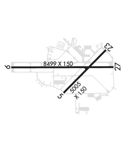
| Lat: N 2759.3 Long: W 08201.1 Elev: 142 Var: +06 Longest Runway: 8500 | ||
| Dept. ATIS: 118.02 Arr. ATIS: 118.02 AWOS: 118.02 Ground: 121.4 Tower: 124.5 | ||
| |||||||||||||||||||||||||||||||||||||||||||||||||||||||||||||||||||||
| |||||||||||||||||||||||||||||||||||||||||||||||||||||||||||||||||||||
| |||||||||||||||||||||||||||||||||||||||||||||||||||||||||||||||||||||
| |||||||||||||||||||||||||||||||||||||||||||||||||||||||||||||||||||||
| Rwy | Rwy | |||||||
| 5000x150 | 5000' | 5000x150 | 5000' | |||||
| 2208x60 | 1846' | 2208x60 | 1652' | |||||
| 8500x150 | 8500' | 110.10 - 095° | 8500x150 | 8500' | ||||
| Runway ID | Single Wheel | Double Wheel | Double Tandem Wheel | Dual Double Wheel |
| 05/23 | 94,000 | 150,000 | N/A | N/A |
| 08/26 | N/A | N/A | N/A | N/A |
| 10/28 | 50,000 | 250,000 | 550,000 | 1,120,000 |
| These numbers are Advisory and are not limits. The Airport Manager should have more accurate Weight Limits | ||||
 Airport Diagram might not be current. | |
| Facility Name: | LAKELAND LINDER INTL |
| City Name: | LAKELAND |
| County: | POLK |
| State abbrev: | FL |
| State Name: | FLORIDA |
| Ownership: | PUBLICLY OWNED |
| Use: | OPEN TO THE PUBLIC |
| Owner's Name: | CITY OF LAKELAND |
| Address: | 3900 DON EMERSON DRIVE SUITE 210 |
| LAKELAND, FL 33811-1340 | |
| Owner's Phone: | 863-834-3298 |
| Manager's Name: | KRIS HALLSTRAND |
| Address: | 3900 DON EMERSON DRIVE SUITE 210 |
| LAKELAND, FL 33811-1340 | |
| Phone: | 863-834-3298 |
| FAA Region: | SOUTHERN |
| FAA Field Office: | ORL |
| Date | Sunrise | Sunset |
|---|---|---|
| 04/03/26 Friday | 7:16 | 19:47 |
| 04/04/26 Saturday | 7:15 | 19:47 |
| 04/05/26 Sunday | 7:14 | 19:48 |
| 04/06/26 Monday | 7:13 | 19:48 |
| 04/07/26 Tuesday | 7:12 | 19:49 |
| 04/08/26 Wednesday | 7:11 | 19:50 |
| 04/09/26 Thursday | 7:10 | 19:50 |
| 04/10/26 Friday | 7:09 | 19:51 |
| 04/11/26 Saturday | 7:08 | 19:51 |
| 04/12/26 Sunday | 7:07 | 19:52 |
| 04/13/26 Monday | 7:06 | 19:52 |
| 04/14/26 Tuesday | 7:04 | 19:53 |
| 04/15/26 Wednesday | 7:03 | 19:53 |
| 04/16/26 Thursday | 7:02 | 19:54 |
| Airport Attendance Schedule | CONTINUOUS |
| Airport Status | OPERATIONAL (This Status can change at any time - please check NOTAMS) |
| Airport Lighting Schedule | PAPI RWY 05 & 23, 10 & 28 OPER CONT. |
| Airport Storage Available | Hanger |
| Extra Services Available | Air Ambulance, Avionics, Cargo Handling, Charter, Flight Instruction, Aircraft Rental, Aircraft Sales |
| Wind Indicator | YES - (unlit) |
| Control Tower | YES |
| CTAF Frequency | |
| Unicom Frequency | 122.950 |
| Rotating Beacon Color | WG |
| Segmented Circle | YES |
| Landing Fee | NO |
| Airport Inspected | FEDERAL - performed by FAA AIRPORTS FIELD PERSONNEL |
| Inspection Date | 02/25/2026 |
| Type of Fuel Available | Grade 100LL, JET A (freeze point -40C) |
| Airframe Repair Service | MAJOR |
| Power Plant Repair Service | MAJOR |
| Latitude | N2759.3 |
| Longitude | W08201.1 (ESTIMATED) |
| Arpt Elevation | 141ft (SURVEYED) |
| Magnetic Variation | 06W |
| 4 miles SW | of LAKELAND |
| Traffic Pattern Altitude | |
| Sectional Chart | MIAMI |
| Operations (Reported) | Yearly | Avg. Daily |
|---|---|---|
| General Aviation Transient | 0 | 0 |
| General Aviation Local | 0 | 0 |
| Air Taxi | 0 | 0 |
| Commerical | 0 | 0 |
| Commuter | 0 | 0 |
| Military | 0 | 0 |
| Aircraft based on Field | |
|---|---|
| General Aviation Singles | 0 |
| General Aviation Multi | 0 |
| Jet Aircraft | 0 |
| General Aviation Helicopters | 0 |
| Military Aircraft | 0 |
| Gliders | 0 |
| Ultralights | 0 |
| FSS on field | NO |
| FSS tie-in | SAINT PETERSBURG |
| FSS Phone | 1-800-WX-BRIEF |
| Who issues Notams | LAL |
| Notam D service at airport | YES |
| ARTCC Name | MIAMI |
| Airport Certification | |
| Aircraft Rescue & Firefighting Index | AIRPORT HAS A CERTIFICATE UNDER CFR PART 139 |
| Airport of Entry | No |
| Custom Landing Rights | No; US CUSTOMS USER FEE ARPT. |
| Joint Civil/Military | No |
| Military Landing rights | YES |
| NATIONAL PLAN OF INTEGRATED AIRPORT SYSTEMS (NPIAS) |
| GRANT AGREEMENTS UNDER FAAP/ADAP/AIP |
| SURPLUS PROPERTY AGREEMENT UNDER PUBLIC LAW 289 |
| SURPLUS PROPERTY AGREEMENT UNDER REGULATION 16-WAA |
| ASSURANCES PURSUANT TO TITLE VI, CIVIL RIGHTS ACT OF 1964 |
| BIRD ACT ON & INVOF ARPT. |
| USCBP USER FEE ARPT; SVC THUR-MON, 1530-2400Z. FEE CHRGD OUTSIDE OF SVC HOURS. FEE PAYABLE ON SITE. |
| 24 HR ADVN NOTICE OR IMT REPORTING UPON LDG FOR ACFT EQUIPPED WITH WEATHER MODIFICATION OR GEOENGINEERING EQUIP CTC ARPT OPS 863-456-7890. |
| TWY D, D1, & E1 UNLGTD. |
| PJE WITHIN 5 NM 18000 BLW SR-SS |
| INDEX C AVBL UPON REQ. |
| RWY 05/2 3 RWY 05/23 NOT AVBL FOR PART 121/PART 380 OPS WITH SKED PAX CARRYING OPS MORE THAN 9 PAX SEATS AND NON-SKED PAX CARRYING OPS MORE THAN 30 PAX SEATS. |
| RWY 08/2 6 RWY 08/26 NOT AVBL FOR PART 121/PART 380 OPS WITH SKED PAX CARRYING OPS MORE THAN 9 PAX SEATS AND NON-SKED PAX CARRYING OPS MORE THAN 30 PAX SEATS. RSTRD TO GROUP 1 ACFT UNDER 1500 LBS MTOW, VFR DAYTIME ONLY, NO TGL; PPR - 863-834-4911. |
| RWY 05/2 3 PCR VALUE: 320/F/A/X/T |
| RWY 10/2 8 PCR VALUE: 460/F/A/X/T |
Airport Communications & Frequencies:
| ||||||||||||||||||||||||||
| Runway: 05 | Runway: 23 | ||
| Mag heading: | 51° | Mag heading: | 231° |
| Rwy Slope: | .22% Up | Rwy Slope: | -.22% Down |
| Approach: | Approach: | ||
| Pattern: | Left Traffic | Pattern: | Left Traffic |
| Markings: | PRECISION INSTRUMENT | Markings: | NONPRECISION INSTRUMENT |
| Marking Condition: | GOOD | Marking Condition: | GOOD |
| Arresting Dev: | Arresting Dev: | ||
| Lat & Long: | N2759.0 W08201.2 | Lat. & Long.: | N2759.6 W08200.6 |
| Elev: | 130.2 ft. MSL | Elev: | 141.1 ft. MSL |
| TCH: | 59 ft. AGL | TCH: | 46 ft. AGL |
| Visual Glide Path: | 3.00 degrees | Visual Glide Path: | 3.00 degrees |
| Displaced Threshold: | No | Displaced Threshold: | No |
| Touchdown Zone: | YES | Touchdown Zone: | YES |
| Touchdown Elev.: | 136.0 feet | Touchdown Elev.: | 141.1 feet |
| Visual Glide Slope: | 4-Light PAPI on LEFT side of Runway | Visual Glide Slope: | 4-Light PAPI on LEFT side of Runway |
| RVR Equipment: | RVR Equipment: | ||
| RVV Equipment: | NO | RVV Equipment: | NO |
| Approach Lights: | Approach Lights: | ||
| REIL: | NO | REIL: | NO |
| Centerline Lights: | NO | Centerline Lights: | NO |
| Touchdown lights: | NO | Touchdown lights: | NO |
| Runway Category: | D | Runway Category: | Runway with a Non-precision Approach having visibility minimums greater than 3/4 mile |
| Declared Distances: | TORA:5000' TODA:5000' ASDA:5000' LDA:5000' | Declared Distances: | TORA:5000' TODA:5000' ASDA:5000' LDA:5000' |
| Obstructions: | Obstructions: | TREES | |
| Marked: | Marked: | NOT Marked/Lighted | |
| Clearance slope: | 50:1 | Clearance slope: | 34:1 |
| Obstruction height: | Obstruction height: | 34 feet AGL | |
| Dist. from runway: | Dist. from runway: | 1380 feet | |
| Centerline offset: | Centerline offset: | 125 feet left of centerline | |
| Comments: | Comments: |
| Runway: 08 | Runway: 26 | ||
| Mag heading: | 96° | Mag heading: | 276° |
| Rwy Slope: | .16% Up | Rwy Slope: | -.16% Down |
| Approach: | Approach: | ||
| Pattern: | Left Traffic | Pattern: | Left Traffic |
| Markings: | NONSTANDARD | Markings: | NONE |
| Marking Condition: | GOOD; RWY 8/26 MKD WITH PAVERS. | Marking Condition: | GOOD |
| Arresting Dev: | Arresting Dev: | ||
| Lat & Long: | N2758.8 W08201.5 | Lat. & Long.: | N2758.8 W08201.1 |
| Elev: | 127.5 ft. MSL | Elev: | 131.1 ft. MSL |
| TCH: | TCH: | ||
| Visual Glide Path: | Visual Glide Path: | ||
| Displaced Threshold: | 362 feet | Displaced Threshold: | 556 feet |
| Touchdown Zone: | YES | Touchdown Zone: | YES |
| Touchdown Elev.: | 132.0 feet | Touchdown Elev.: | 131.2 feet |
| Visual Glide Slope: | Visual Glide Slope: | ||
| RVR Equipment: | RVR Equipment: | ||
| RVV Equipment: | NO | RVV Equipment: | NO |
| Approach Lights: | Approach Lights: | ||
| REIL: | NO | REIL: | NO |
| Centerline Lights: | NO | Centerline Lights: | NO |
| Touchdown lights: | NO | Touchdown lights: | NO |
| Runway Category: | Runway with a Visual Approach | Runway Category: | Runway with a Visual Approach |
| Declared Distances: | TORA:1650' TODA:2010' ASDA:2205' LDA:1845' | Declared Distances: | TORA:1845' TODA:2205' ASDA:2205' LDA:1650' |
| Obstructions: | TREES | Obstructions: | HANGAR |
| Marked: | NOT Marked/Lighted | Marked: | NOT Marked/Lighted |
| Clearance slope: | 16:1 | Clearance slope: | 11:1 |
| Obstruction height: | 51 feet AGL | Obstruction height: | 55 feet AGL |
| Dist. from runway: | 820 feet | Dist. from runway: | 650 feet |
| Centerline offset: | 200 right of centerline | Centerline offset: | 145 feet right of centerline |
| Comments: | Comments: |
| Runway: 10 | Runway: 28 | ||
| Mag heading: | 96° | Mag heading: | 276° |
| Rwy Slope: | .12% Up | Rwy Slope: | -.12% Down |
| Approach: | ILS/DME | Approach: | |
| Pattern: | Left Traffic | Pattern: | Left Traffic |
| Markings: | PRECISION INSTRUMENT | Markings: | NONPRECISION INSTRUMENT |
| Marking Condition: | GOOD | Marking Condition: | GOOD |
| Arresting Dev: | Arresting Dev: | ||
| Lat & Long: | N2759.4 W08202.0 | Lat. & Long.: | N2759.4 W08200.5 |
| Elev: | 131.7 ft. MSL | Elev: | 141.8 ft. MSL |
| TCH: | 71 ft. AGL | TCH: | 71 ft. AGL |
| Visual Glide Path: | 3.00 degrees | Visual Glide Path: | 3.00 degrees |
| Displaced Threshold: | No | Displaced Threshold: | No |
| Touchdown Zone: | YES | Touchdown Zone: | YES |
| Touchdown Elev.: | 131.7 feet | Touchdown Elev.: | 141.8 feet |
| Visual Glide Slope: | 4-Light PAPI on RIGHT side of Runway | Visual Glide Slope: | 4-Light PAPI on LEFT side of Runway |
| RVR Equipment: | TOUCHDOWN-MIDFIELD-ROLLOUT | RVR Equipment: | TOUCHDOWN-MIDFIELD-ROLLOUT |
| RVV Equipment: | NO | RVV Equipment: | NO |
| Approach Lights: | ALSF2 - standard 2,400 foot high intensity approach lighting system with sequenced flashers, Category II or III | Approach Lights: | |
| REIL: | NO | REIL: | NO |
| Centerline Lights: | YES | Centerline Lights: | YES |
| Touchdown lights: | YES | Touchdown lights: | NO |
| Runway Category: | Precision Instrument Runway | Runway Category: | D |
| Declared Distances: | TORA:8500' TODA:8500' ASDA:8500' LDA:8500' | Declared Distances: | TORA:8500' TODA:8500' ASDA:8500' LDA:8500' |
| Obstructions: | Obstructions: | TREES | |
| Marked: | Marked: | NOT Marked/Lighted | |
| Clearance slope: | 50:1 | Clearance slope: | 30:1 |
| Obstruction height: | Obstruction height: | 30 feet AGL | |
| Dist. from runway: | Dist. from runway: | 1110 feet | |
| Centerline offset: | Centerline offset: | 455B | |
| Comments: | Comments: |
Thanks for using FltPlan.com
all rights reserved © 1999-2026 by Flight Plan LLC


