
| WASCO-KERN COUNTY WASCO CA |
| |
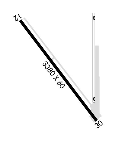
| Lat: N 3537.2 Long: W 11921.2 Elev: 312 Var: -15 Longest Runway: 3380 | ||
| CTAF: 122.8 | ||
| ||||||
|
| Rwy | Rwy | |||||||
| 3380x60 | 2949' | 3380x60 | 3150' | |||||
| Runway ID | Single Wheel | Double Wheel | Double Tandem Wheel | Dual Double Wheel |
| 12/30 | 6,000 | N/A | N/A | N/A |
| These numbers are Advisory and are not limits. The Airport Manager should have more accurate Weight Limits | ||||
| FltPlan does not have IFR approach charts available for KL19. |
 Airport Diagram might not be current. | |
| Facility Name: | WASCO-KERN COUNTY |
| City Name: | WASCO |
| County: | KERN |
| State abbrev: | CA |
| State Name: | CALIFORNIA |
| Ownership: | PUBLICLY OWNED |
| Use: | OPEN TO THE PUBLIC |
| Owner's Name: | KERN COUNTY DEPT OF AIRPORTS |
| Address: | 3701 WINGS WAY, SUITE 300 |
| BAKERSFIELD, CA 93308-7026 | |
| Owner's Phone: | 661-391-1800 |
| Manager's Name: | RON BREWSTER; RON BREWSTER CHIEF OPERATIONS OFFICER KERN COUNTY AIRPORTS OFFICE (661) 391-1825 BREWSTERR@CO.KERN.CA.US CELL (661) 889-5273 |
| Address: | 3701 WINGS WAY, SUITE 300 |
| BAKERSFIELD, CA 93308-7026; RON BREWSTER, OPERATIONS MANAGER | |
| Phone: | 661-391-1824; RESIDENT CUSTODIAN ON ARPT. 24 HRS: (661) 393-3868 FAX: (661) 391-1801 EMAIL: BFLSECURITY@CO.KERN.CA.US |
| FAA Region: | WESTERN-PACIFIC |
| FAA Field Office: | LAX |
| Date | Sunrise | Sunset |
|---|---|---|
| 09/24/21 Friday | 6:47 | 18:52 |
| 09/25/21 Saturday | 6:48 | 18:50 |
| 09/26/21 Sunday | 6:48 | 18:49 |
| 09/27/21 Monday | 6:49 | 18:47 |
| 09/28/21 Tuesday | 6:50 | 18:46 |
| 09/29/21 Wednesday | 6:51 | 18:44 |
| 09/30/21 Thursday | 6:51 | 18:43 |
| 10/01/21 Friday | 6:52 | 18:41 |
| 10/02/21 Saturday | 6:53 | 18:40 |
| 10/03/21 Sunday | 6:54 | 18:39 |
| 10/04/21 Monday | 6:55 | 18:37 |
| 10/05/21 Tuesday | 6:55 | 18:36 |
| 10/06/21 Wednesday | 6:56 | 18:34 |
| 10/07/21 Thursday | 6:57 | 18:33 |
| Airport Attendance Schedule | IRREGULAR |
| Airport Status | OPERATIONAL (This Status can change at any time - please check NOTAMS) |
| Airport Lighting Schedule | ACTVT MIRL RWY 12/30 - CTAF. |
| Airport Storage Available | Tie Downs |
| Extra Services Available | Crop Dusting |
| Wind Indicator | YES - (lighted) |
| Control Tower | NO |
| CTAF Frequency | 122.800 |
| Unicom Frequency | 122.800 |
| Rotating Beacon Color | CLEAR-GREEN (Light Land Airport) |
| Segmented Circle | YES |
| Landing Fee | NO |
| Airport Inspected | STATE - performed by STATE AERONAUTICAL PERSONNEL |
| Inspection Date | 02/13/2020 |
| Type of Fuel Available | Grade 100LL; -10FUEL AVBL BY PHONE CALL ONLY (661) 758-3009. |
| Airframe Repair Service | NONE |
| Power Plant Repair Service | NONE |
| Latitude | N3537.2 |
| Longitude | W11921.2 (ESTIMATED) |
| Arpt Elevation | 312ft (SURVEYED) |
| Magnetic Variation | 15E |
| 2 miles NW | of WASCO |
| Traffic Pattern Altitude | 800; TPA 1113 MSL. |
| Sectional Chart | LOS ANGELES |
| Operations (Reported) | Yearly | Avg. Daily |
|---|---|---|
| General Aviation Transient | 1000 | 3 |
| General Aviation Local | 8000 | 22 |
| Air Taxi | 1000 | 3 |
| Commerical | 0 | 0 |
| Commuter | 0 | 0 |
| Military | 0 | 0 |
| Aircraft based on Field | |
|---|---|
| General Aviation Singles | 6 |
| General Aviation Multi | 0 |
| Jet Aircraft | 0 |
| General Aviation Helicopters | 0 |
| Military Aircraft | 0 |
| Gliders | 0 |
| Ultralights | 0 |
| FSS on field | NO |
| FSS tie-in | RANCHO MURIETA |
| FSS Phone | 1-800-WX-BRIEF |
| Who issues Notams | RIU |
| Notam D service at airport | YES |
| ARTCC Name | LOS ANGELES |
| Airport Certification | |
| Aircraft Rescue & Firefighting Index | None |
| Airport of Entry | No |
| Custom Landing Rights | No |
| Joint Civil/Military | No |
| Military Landing rights | YES |
| NATIONAL PLAN OF INTEGRATED AIRPORT SYSTEMS (NPIAS) |
| GRANT AGREEMENTS UNDER FAAP/ADAP/AIP |
| ASSURANCES PURSUANT TO TITLE VI, CIVIL RIGHTS ACT OF 1964 |
| CROP DUSTING OPNS PROHIBITED EXCP BY AMGR 661-393-1800. |
| FOR CD CTC LOS ANGELES ARTCC AT 661-575-2079. |
| RWY 12/3 0 RY 12 LGTD THLD RELCTD 455 FT; RY 30 LGTD THLD RELCTD 240 FT FOR NIGHT OPNS; 2685 FT OF RY 12/30 USBL AT NIGHT. |
| Runway: 12 | Runway: 30 | ||
| Mag heading: | 120° | Mag heading: | 300° |
| Rwy Slope: | .28% Up | Rwy Slope: | -.28% Down |
| Approach: | Approach: | ||
| Pattern: | Left Traffic | Pattern: | Left Traffic |
| Markings: | BASIC | Markings: | BASIC |
| Marking Condition: | GOOD | Marking Condition: | GOOD |
| Arresting Dev: | Arresting Dev: | ||
| Lat & Long: | N3537.4 W11921.5 | Lat. & Long.: | N3537.0 W11921.0 |
| Elev: | 302.5 ft. MSL | Elev: | 312.0 ft. MSL |
| TCH: | TCH: | ||
| Visual Glide Path: | Visual Glide Path: | ||
| Displaced Threshold: | 431 feet | Displaced Threshold: | 230 feet |
| Touchdown Zone: | YES | Touchdown Zone: | YES |
| Touchdown Elev.: | 312.0 feet | Touchdown Elev.: | 312.0 feet |
| Visual Glide Slope: | Visual Glide Slope: | ||
| RVR Equipment: | RVR Equipment: | ||
| RVV Equipment: | NO | RVV Equipment: | NO |
| Approach Lights: | Approach Lights: | ||
| REIL: | NO | REIL: | NO |
| Centerline Lights: | NO | Centerline Lights: | NO |
| Touchdown lights: | NO | Touchdown lights: | NO |
| Runway Category: | Runway with a Visual Approach | Runway Category: | Runway with a Visual Approach |
| Declared Distances: | Declared Distances: | ||
| Obstructions: | POLE | Obstructions: | ROAD |
| Marked: | NOT Marked/Lighted | Marked: | NOT Marked/Lighted |
| Clearance slope: | +35 FT POLES RIGHT TO LEFT 600 FT FM DSPLCD THLD. RY 12 APCH RATIO 18:1 TO DSPLCD THLD. | Clearance slope: | RY 30 APCH RATIO 26:1 TO DSPLCD THLD. |
| Obstruction height: | 35 feet AGL | Obstruction height: | 15 feet AGL |
| Dist. from runway: | 200 feet | Dist. from runway: | 200 feet |
| Centerline offset: | Centerline offset: | ||
| Comments: | +6' FENCE & +15' RD 0' TO 70' FM RY END 80' L TO 70' R. | Comments: | +4' FENCE 85' TO 180' FM RY END 125' L TO 125' R; +15' RD 105' TO 200' FM RY END 125' L TO 125' R; +8' SIGN 200' FM RY END 0' L. |
Thanks for using FltPlan.com
all rights reserved © 1999-2021 by Flight Plan LLC
