| JOHN C TUNE NASHVILLE TN |
| |
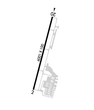
| Lat: N 3611.0 Long: W 08653.2 Elev: 501 Var: +03 Longest Runway: 6001 | ||
| Clr Del: 124.55 AWOS: 127.07 CTAF: 122.7 | ||
| |||||||||||||||||||||||||||||||||||||||||||||||||||||||||||||||||||||
| |||||||||||||||||||||||||||||||||||||||||||||||||||||||||||||||||||||
| |||||||||||||||||||||||||||||||||||||||||||||||||||||||||||||||||||||
| Rwy | Rwy | |||||||
| 6001x100 | 6001' | 6001x100 | 6001' | 110.30 - 197° | ||||
| Runway ID | Single Wheel | Double Wheel | Double Tandem Wheel | Dual Double Wheel |
| 02/20 | 35,000 | 97,000 | N/A | N/A |
| These numbers are Advisory and are not limits. The Airport Manager should have more accurate Weight Limits | ||||
 Airport Diagram might not be current. | |
| Facility Name: | JOHN C TUNE |
| City Name: | NASHVILLE |
| County: | DAVIDSON |
| State abbrev: | TN |
| State Name: | TENNESSEE |
| Ownership: | PUBLICLY OWNED |
| Use: | OPEN TO THE PUBLIC |
| Owner's Name: | METRO NASHVILLE APT AUTHORITY |
| Address: | ONE TERMINAL DR. |
| NASHVILLE, TN 37214 | |
| Owner's Phone: | 615-275-1600 |
| Manager's Name: | TOM BIBB |
| Address: | 110 TUNE AIRPORT DRIVE |
| NASHVILLE, TN 37209 | |
| Phone: | 615-350-6551; MANAGER CELL: 615-347-4196 |
| FAA Region: | SOUTHERN |
| FAA Field Office: | MEM |
| Date | Sunrise | Sunset |
|---|---|---|
| 09/24/21 Friday | 6:37 | 18:42 |
| 09/25/21 Saturday | 6:38 | 18:40 |
| 09/26/21 Sunday | 6:38 | 18:39 |
| 09/27/21 Monday | 6:39 | 18:37 |
| 09/28/21 Tuesday | 6:40 | 18:36 |
| 09/29/21 Wednesday | 6:41 | 18:34 |
| 09/30/21 Thursday | 6:42 | 18:33 |
| 10/01/21 Friday | 6:42 | 18:31 |
| 10/02/21 Saturday | 6:43 | 18:30 |
| 10/03/21 Sunday | 6:44 | 18:29 |
| 10/04/21 Monday | 6:45 | 18:27 |
| 10/05/21 Tuesday | 6:46 | 18:26 |
| 10/06/21 Wednesday | 6:47 | 18:24 |
| 10/07/21 Thursday | 6:47 | 18:23 |
| Airport Attendance Schedule | CONTINUOUS |
| Airport Status | OPERATIONAL (This Status can change at any time - please check NOTAMS) |
| Airport Lighting Schedule | SS-SR |
| Airport Storage Available | Tie Downs, Hanger |
| Extra Services Available | Avionics, Charter, Flight Instruction, Aircraft Rental, Aircraft Sales |
| Wind Indicator | YES - (lighted) |
| Control Tower | NO |
| CTAF Frequency | 122.700 |
| Unicom Frequency | 122.700 |
| Rotating Beacon Color | CLEAR-GREEN (Light Land Airport) |
| Segmented Circle | YES |
| Landing Fee |
| Airport Inspected | STATE - performed by STATE AERONAUTICAL PERSONNEL |
| Inspection Date | 10/15/2020 |
| Type of Fuel Available | Grade 100LL, JET A |
| Airframe Repair Service | MAJOR |
| Power Plant Repair Service | MAJOR |
| Latitude | N3611.0 |
| Longitude | W08653.2 (ESTIMATED) |
| Arpt Elevation | 501ft (SURVEYED) |
| Magnetic Variation | 03W |
| 1 miles NW | of NASHVILLE |
| Traffic Pattern Altitude | |
| Sectional Chart | ST LOUIS |
| Operations (Reported) | Yearly | Avg. Daily |
|---|---|---|
| General Aviation Transient | 33160 | 91 |
| General Aviation Local | 26025 | 71 |
| Air Taxi | 24345 | 67 |
| Commerical | 0 | 0 |
| Commuter | 0 | 0 |
| Military | 420 | 1 |
| Aircraft based on Field | |
|---|---|
| General Aviation Singles | 104 |
| General Aviation Multi | 21 |
| Jet Aircraft | 19 |
| General Aviation Helicopters | 10 |
| Military Aircraft | 0 |
| Gliders | 0 |
| Ultralights | 0 |
| FSS on field | NO |
| FSS tie-in | NASHVILLE |
| FSS Phone | 1-800-WX-BRIEF |
| Who issues Notams | BNA |
| Notam D service at airport | YES |
| ARTCC Name | MEMPHIS |
| Airport Certification | |
| Aircraft Rescue & Firefighting Index | None |
| Airport of Entry | No |
| Custom Landing Rights | No |
| Joint Civil/Military | No |
| Military Landing rights | No |
| NATIONAL PLAN OF INTEGRATED AIRPORT SYSTEMS (NPIAS) |
| GRANT AGREEMENTS UNDER FAAP/ADAP/AIP |
| ASSURANCES PURSUANT TO TITLE VI, CIVIL RIGHTS ACT OF 1964 |
| DEER INVOF ARPT. |
| FREQ BLEEDOVER OCCURS ON ALL FREQS 1.75 NM NORTH OF RY 02/20. |
| BIRD ACTIVITY INVOF ARPT. |
| RY 20 PREFERRED CALM WIND RY. |
| FOR CD CTC NASHVILLE APCH ON 124.55, IF UN CALL 615-695-4524. |
Airport Communications & Frequencies:
| ||||||||||||||||
| Runway: 02 | Runway: 20 | ||
| Mag heading: | 18° | Mag heading: | 198° |
| Rwy Slope: | .71% Up | Rwy Slope: | -.71% Down |
| Approach: | Approach: | ILS/DME | |
| Pattern: | Left Traffic | Pattern: | Right Traffic |
| Markings: | NONPRECISION INSTRUMENT | Markings: | PRECISION INSTRUMENT |
| Marking Condition: | GOOD | Marking Condition: | GOOD |
| Arresting Dev: | Arresting Dev: | ||
| Lat & Long: | N3610.5 W08653.3 | Lat. & Long.: | N3611.5 W08653.0 |
| Elev: | 458.6 ft. MSL | Elev: | 501.0 ft. MSL |
| TCH: | 40 ft. AGL | TCH: | 40 ft. AGL |
| Visual Glide Path: | 3.00 degrees | Visual Glide Path: | 3.00 degrees |
| Displaced Threshold: | No | Displaced Threshold: | No |
| Touchdown Zone: | YES | Touchdown Zone: | YES |
| Touchdown Elev.: | 483.6 feet | Touchdown Elev.: | 501.0 feet |
| Visual Glide Slope: | 4-Light PAPI on LEFT side of Runway | Visual Glide Slope: | 4-Light PAPI on LEFT side of Runway |
| RVR Equipment: | RVR Equipment: | ||
| RVV Equipment: | NO | RVV Equipment: | NO |
| Approach Lights: | Approach Lights: | ||
| REIL: | YES | REIL: | YES |
| Centerline Lights: | NO | Centerline Lights: | NO |
| Touchdown lights: | NO | Touchdown lights: | NO |
| Runway Category: | Runway with a Non-precision Approach having visibility minimums greater than 3/4 mile | Runway Category: | Precision Instrument Runway |
| Declared Distances: | TORA:6001' TODA:6001' ASDA:6001' LDA:6001' | Declared Distances: | TORA:6001' TODA:6001' ASDA:6001' LDA:6001' |
| Obstructions: | TREE | Obstructions: | TREE |
| Marked: | NOT Marked/Lighted | Marked: | NOT Marked/Lighted |
| Clearance slope: | 26:1 | Clearance slope: | 30:1 |
| Obstruction height: | 49 feet AGL | Obstruction height: | 63 feet AGL |
| Dist. from runway: | 1496 feet | Dist. from runway: | 2115 feet |
| Centerline offset: | 475 right of centerline | Centerline offset: | 361 feet right of centerline |
| Comments: | Comments: |
Thanks for using FltPlan.com
all rights reserved © 1999-2021 by Flight Plan LLC