| INDIANAPOLIS INTL INDIANAPOLIS IN |
| |
| Lat: N 3943.0 Long: W 08617.7 Elev: 796 Var: +05 Longest Runway: 11200 | ||
| Clr Del: 128.75 Dept. ATIS: 134.25 Arr. ATIS: 134.25 Ground: 121.8/121.9 Tower: 120.9 | ||
| |||||||||||||||||||||||||||||||||||||||||||||||||||||||||||||||||||||
| |||||||||||||||||||||||||||||||||||||||||||||||||||||||||||||||||||||
| |||||||||||||||||||||||||||||||||||||||||||||||||||||||||||||||||||||
| |||||||||||||||||||||||||||||||||||||||||||||||||||||||||||||||||||||
| FBOs at nearby airports who want your business: | |||||||||||||||||
| |||||||||||||||||
| |||||||||||||||||
| |||||||||||||||||
| Rwy | Rwy | |||||||
| 11200x150 | 11200' | 111.75 - 049° | 11200x150 | 11200' | 111.75 - 229° | |||
| 10000x150 | 10000' | 111.15 - 049° | 10000x150 | 10000' | 111.15 - 229° | |||
| 7278x150 | 7278' | 110.50 - 139° | 7278x150 | 7278' | 110.50 - 319° | |||
| Runway ID | Single Wheel | Double Wheel | Double Tandem Wheel | Dual Double Wheel |
| 05L/23R | 145,000 | 300,000 | 550,000 | N/A |
| 05R/23L | 145,000 | 300,000 | 550,000 | N/A |
| 14/32 | 145,000 | 300,000 | 550,000 | N/A |
| These numbers are Advisory and are not limits. The Airport Manager should have more accurate Weight Limits | ||||
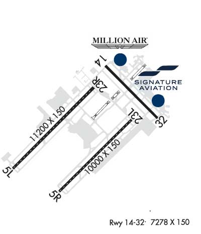 Airport Diagram might not be current. | |
| Facility Name: | INDIANAPOLIS INTL |
| City Name: | INDIANAPOLIS |
| County: | MARION |
| State abbrev: | IN |
| State Name: | INDIANA |
| Ownership: | PUBLICLY OWNED |
| Use: | OPEN TO THE PUBLIC |
| Owner's Name: | INDIANAPOLIS AIRPORT AUTH |
| Address: | 7800 COL. H. WEIR COOK MEMORIAL DR. |
| INDIANAPOLIS, IN 46241 | |
| Owner's Phone: | 317-487-9594 |
| Manager's Name: | MARIO RODRIGUEZ |
| Address: | 7800 COL. H. WEIR COOK MEMORIAL DR. |
| INDIANAPOLIS, IN 46241 | |
| Phone: | 317-487-9594 |
| FAA Region: | GREAT LAKES |
| FAA Field Office: | CHI |
| Date | Sunrise | Sunset |
|---|---|---|
| 09/24/21 Friday | 7:34 | 19:39 |
| 09/25/21 Saturday | 7:35 | 19:38 |
| 09/26/21 Sunday | 7:36 | 19:36 |
| 09/27/21 Monday | 7:37 | 19:34 |
| 09/28/21 Tuesday | 7:38 | 19:33 |
| 09/29/21 Wednesday | 7:39 | 19:31 |
| 09/30/21 Thursday | 7:40 | 19:30 |
| 10/01/21 Friday | 7:41 | 19:28 |
| 10/02/21 Saturday | 7:42 | 19:26 |
| 10/03/21 Sunday | 7:43 | 19:25 |
| 10/04/21 Monday | 7:44 | 19:23 |
| 10/05/21 Tuesday | 7:45 | 19:22 |
| 10/06/21 Wednesday | 7:46 | 19:20 |
| 10/07/21 Thursday | 7:47 | 19:18 |
| Airport Attendance Schedule | CONTINUOUS |
| Airport Status | OPERATIONAL (This Status can change at any time - please check NOTAMS) |
| Airport Lighting Schedule | |
| Airport Storage Available | Tie Downs |
| Extra Services Available | Cargo Handling |
| Wind Indicator | YES - (lighted) |
| Control Tower | YES |
| CTAF Frequency | |
| Unicom Frequency | 122.950 |
| Rotating Beacon Color | CLEAR-GREEN (Light Land Airport) |
| Segmented Circle | NO |
| Landing Fee |
| Airport Inspected | FEDERAL - performed by FAA AIRPORTS FIELD PERSONNEL |
| Inspection Date | 11/07/2019 |
| Type of Fuel Available | Grade 100LL, JET A (freeze point -40C), JET A-1 (icing inhibitor, freeze point -50C) |
| Airframe Repair Service | MAJOR |
| Power Plant Repair Service | MAJOR |
| Latitude | N3943.0 |
| Longitude | W08617.7 (ESTIMATED) |
| Arpt Elevation | 796ft (SURVEYED) |
| Magnetic Variation | 05W |
| 7 miles SW | of INDIANAPOLIS |
| Traffic Pattern Altitude | |
| Sectional Chart | ST LOUIS |
| Operations (Reported) | Yearly | Avg. Daily |
|---|---|---|
| General Aviation Transient | 14102 | 39 |
| General Aviation Local | 0 | 0 |
| Air Taxi | 47231 | 129 |
| Commerical | 125093 | 343 |
| Commuter | 0 | 0 |
| Military | 858 | 2 |
| Aircraft based on Field | |
|---|---|
| General Aviation Singles | 15 |
| General Aviation Multi | 9 |
| Jet Aircraft | 33 |
| General Aviation Helicopters | 1 |
| Military Aircraft | 0 |
| Gliders | 0 |
| Ultralights | 0 |
| FSS on field | NO |
| FSS tie-in | TERRE HAUTE |
| FSS Phone | 1-800-WX-BRIEF |
| Who issues Notams | IND |
| Notam D service at airport | YES |
| ARTCC Name | INDIANAPOLIS |
| Airport Certification | AIRPORT RECEIVING SCHEDULED AIR CARRIER SERVICE FROM CARRIERS CERTIFICATED BY THE CIVIL AERONAUTICS BOARD |
| Aircraft Rescue & Firefighting Index | AIRPORT HAS A CERTIFICATE UNDER CFR PART 139 |
| Airport of Entry | No |
| Custom Landing Rights | YES |
| Joint Civil/Military | No |
| Military Landing rights | YES |
| NATIONAL PLAN OF INTEGRATED AIRPORT SYSTEMS (NPIAS) |
| GRANT AGREEMENTS UNDER FAAP/ADAP/AIP |
| SURPLUS PROPERTY AGREEMENT UNDER PUBLIC LAW 289 |
| ASSURANCES PURSUANT TO TITLE VI, CIVIL RIGHTS ACT OF 1964 |
| AGREEMENT UNDER DLAND OR DCLA HAS EXPIRED. |
| PRIM STUDENT TGL NOT PMTD. |
| TWY V IS NOT AVBL FOR ACR OPS. |
| LARGE FLOCKS OF BIRDS ON & INVOF ARPT. |
| NOISE ABATEMENT PROCEDURES IN EFFECT CTC ARPT MGR. |
| BE ALERT TO CLOSE PROXIMITY OF RWY 14/32 TO NORTHEAST RAMP. |
| TWY H RUNS CONTIGUOUS AT NORTHEAST RAMP. |
Airport Communications & Frequencies:
| |||||||||||||||||||||||||||||||||||||||||||||||||
| Runway: 05L | Runway: 23R | ||
| Mag heading: | 50° | Mag heading: | 230° |
| Rwy Slope: | .40% Up | Rwy Slope: | -.40% Down |
| Approach: | ILS/DME | Approach: | ILS/DME |
| Pattern: | Left Traffic | Pattern: | Left Traffic |
| Markings: | PRECISION INSTRUMENT | Markings: | PRECISION INSTRUMENT |
| Marking Condition: | GOOD | Marking Condition: | GOOD |
| Arresting Dev: | Arresting Dev: | ||
| Lat & Long: | N3942.4 W08619.2 | Lat. & Long.: | N3943.7 W08617.6 |
| Elev: | 738.0 ft. MSL | Elev: | 782.9 ft. MSL |
| TCH: | 74 ft. AGL | TCH: | 71 ft. AGL |
| Visual Glide Path: | 3.00 degrees | Visual Glide Path: | 3.00 degrees |
| Displaced Threshold: | No | Displaced Threshold: | No |
| Touchdown Zone: | YES | Touchdown Zone: | YES |
| Touchdown Elev.: | 747.3 feet | Touchdown Elev.: | 782.9 feet |
| Visual Glide Slope: | 4-Light PAPI on LEFT side of Runway | Visual Glide Slope: | 4-Light PAPI on LEFT side of Runway |
| RVR Equipment: | TOUCHDOWN-MIDFIELD-ROLLOUT | RVR Equipment: | TOUCHDOWN-MIDFIELD-ROLLOUT |
| RVV Equipment: | NO | RVV Equipment: | NO |
| Approach Lights: | ALSF2 - standard 2,400 foot high intensity approach lighting system with sequenced flashers, Category II or III | Approach Lights: | MALSR - 1,400 foot medium intensity approach lighting system with runway alignment indicator lights |
| REIL: | NO | REIL: | NO |
| Centerline Lights: | YES | Centerline Lights: | YES |
| Touchdown lights: | YES | Touchdown lights: | NO |
| Runway Category: | Precision Instrument Runway | Runway Category: | Precision Instrument Runway |
| Declared Distances: | TORA:11200' TODA:11200' ASDA:11200' LDA:11200' | Declared Distances: | TORA:11200' TODA:11200' ASDA:11200' LDA:11200' |
| Runway: 05R | Runway: 23L | ||
| Mag heading: | 50° | Mag heading: | 230° |
| Rwy Slope: | -.01% Down | Rwy Slope: | .01% Up |
| Approach: | ILS/DME | Approach: | ILS/DME |
| Pattern: | Left Traffic | Pattern: | Left Traffic |
| Markings: | PRECISION INSTRUMENT | Markings: | PRECISION INSTRUMENT |
| Marking Condition: | GOOD | Marking Condition: | GOOD |
| Arresting Dev: | Arresting Dev: | ||
| Lat & Long: | N3942.0 W08618.3 | Lat. & Long.: | N3943.2 W08616.8 |
| Elev: | 788.8 ft. MSL | Elev: | 787.6 ft. MSL |
| TCH: | 71 ft. AGL | TCH: | 75 ft. AGL |
| Visual Glide Path: | 3.00 degrees | Visual Glide Path: | 3.00 degrees |
| Displaced Threshold: | No | Displaced Threshold: | No |
| Touchdown Zone: | YES | Touchdown Zone: | YES |
| Touchdown Elev.: | 790.7 feet | Touchdown Elev.: | 790.1 feet |
| Visual Glide Slope: | 4-Light PAPI on LEFT side of Runway | Visual Glide Slope: | 4-Light PAPI on RIGHT side of Runway |
| RVR Equipment: | TOUCHDOWN-MIDFIELD-ROLLOUT | RVR Equipment: | TOUCHDOWN-MIDFIELD-ROLLOUT |
| RVV Equipment: | NO | RVV Equipment: | NO |
| Approach Lights: | ALSF2 - standard 2,400 foot high intensity approach lighting system with sequenced flashers, Category II or III | Approach Lights: | MALSR - 1,400 foot medium intensity approach lighting system with runway alignment indicator lights |
| REIL: | NO | REIL: | NO |
| Centerline Lights: | YES | Centerline Lights: | YES |
| Touchdown lights: | YES | Touchdown lights: | NO |
| Runway Category: | Precision Instrument Runway | Runway Category: | Precision Instrument Runway |
| Declared Distances: | TORA:10000' TODA:10000' ASDA:10000' LDA:10000' | Declared Distances: | TORA:10000' TODA:10000' ASDA:10000' LDA:10000' |
| Obstructions: | Obstructions: | ANT | |
| Marked: | Marked: | NOT Marked/Lighted | |
| Clearance slope: | 50:1 | Clearance slope: | 48:1 |
| Obstruction height: | Obstruction height: | 78 feet AGL | |
| Dist. from runway: | Dist. from runway: | 3960 feet | |
| Centerline offset: | Centerline offset: | 484 feet right of centerline | |
| Comments: | Comments: |
| Runway: 14 | Runway: 32 | ||
| Mag heading: | 140° | Mag heading: | 320° |
| Rwy Slope: | -.07% Down | Rwy Slope: | .07% Up |
| Approach: | ILS | Approach: | ILS |
| Pattern: | Left Traffic | Pattern: | Left Traffic |
| Markings: | PRECISION INSTRUMENT | Markings: | PRECISION INSTRUMENT |
| Marking Condition: | GOOD | Marking Condition: | GOOD |
| Arresting Dev: | Arresting Dev: | ||
| Lat & Long: | N3944.1 W08617.3 | Lat. & Long.: | N3943.2 W08616.2 |
| Elev: | 787.5 ft. MSL | Elev: | 782.6 ft. MSL |
| TCH: | 74 ft. AGL | TCH: | 73 ft. AGL |
| Visual Glide Path: | 3.00 degrees | Visual Glide Path: | 3.00 degrees |
| Displaced Threshold: | No | Displaced Threshold: | No |
| Touchdown Zone: | YES | Touchdown Zone: | YES |
| Touchdown Elev.: | 796.2 feet | Touchdown Elev.: | 792.9 feet |
| Visual Glide Slope: | 4-Light PAPI on LEFT side of Runway; UNUSBL BYD 8 DEG RGT OF COURSE. | Visual Glide Slope: | 4-Light PAPI on RIGHT side of Runway |
| RVR Equipment: | TOUCHDOWN-ROLLOUT | RVR Equipment: | TOUCHDOWN-ROLLOUT |
| RVV Equipment: | NO | RVV Equipment: | YES |
| Approach Lights: | MALSR - 1,400 foot medium intensity approach lighting system with runway alignment indicator lights | Approach Lights: | MALSR - 1,400 foot medium intensity approach lighting system with runway alignment indicator lights |
| REIL: | NO | REIL: | NO |
| Centerline Lights: | NO | Centerline Lights: | NO |
| Touchdown lights: | NO | Touchdown lights: | NO |
| Runway Category: | Precision Instrument Runway | Runway Category: | Precision Instrument Runway |
| Declared Distances: | TORA:7278' TODA:7278' ASDA:7278' LDA:7278' | Declared Distances: | TORA:7278' TODA:7278' ASDA:7278' LDA:7278' |
| Obstructions: | ANT | Obstructions: | |
| Marked: | NOT Marked/Lighted | Marked: | |
| Clearance slope: | 35:1 | Clearance slope: | 50:1 |
| Obstruction height: | 61 feet AGL | Obstruction height: | |
| Dist. from runway: | 2370 feet | Dist. from runway: | |
| Centerline offset: | 756 left of centerline | Centerline offset: | |
| Comments: | Comments: |
Thanks for using FltPlan.com
all rights reserved © 1999-2021 by Flight Plan LLC