
| JACK BARSTOW MIDLAND MI |
| |
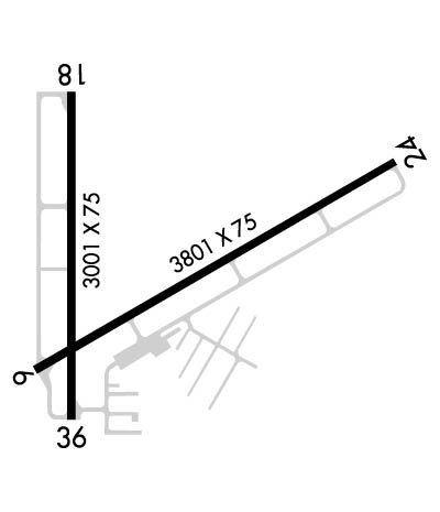
| Lat: N 4339.8 Long: W 08415.7 Elev: 635 Var: +06 Longest Runway: 3801 | ||
| AWOS: 119.52 CTAF: 122.8 | ||
| ||||||
| ||||||
|
| Rwy | Rwy | |||||||
| 3801x75 | 3801' | 3801x75 | 3801' | |||||
| 3001x75 | 3001' | 3001x75 | 3001' | |||||
| Runway ID | Single Wheel | Double Wheel | Double Tandem Wheel | Dual Double Wheel |
| 06/24 | 24,000 | N/A | N/A | N/A |
| 18/36 | 24,000 | N/A | N/A | N/A |
| These numbers are Advisory and are not limits. The Airport Manager should have more accurate Weight Limits | ||||
 Airport Diagram might not be current. | |
| Facility Name: | JACK BARSTOW |
| City Name: | MIDLAND |
| County: | MIDLAND |
| State abbrev: | MI |
| State Name: | MICHIGAN |
| Ownership: | PUBLICLY OWNED |
| Use: | OPEN TO THE PUBLIC |
| Owner's Name: | CITY OF MIDLAND |
| Address: | 333 W ELLSWORTH ST |
| MIDLAND, MI 48640-5132 | |
| Owner's Phone: | 989-837-3300; ARPT TEL 989-835-3231. |
| Manager's Name: | JOSHUA FREDRICKSON |
| Address: | 333 W ELLSWORTH ST |
| MIDLAND, MI 48640-5132 | |
| Phone: | 989-835-3231 |
| FAA Region: | GREAT LAKES |
| FAA Field Office: | DET |
| Date | Sunrise | Sunset |
|---|---|---|
| 09/24/21 Friday | 7:26 | 19:31 |
| 09/25/21 Saturday | 7:27 | 19:29 |
| 09/26/21 Sunday | 7:29 | 19:28 |
| 09/27/21 Monday | 7:30 | 19:26 |
| 09/28/21 Tuesday | 7:31 | 19:24 |
| 09/29/21 Wednesday | 7:32 | 19:22 |
| 09/30/21 Thursday | 7:33 | 19:20 |
| 10/01/21 Friday | 7:34 | 19:18 |
| 10/02/21 Saturday | 7:35 | 19:17 |
| 10/03/21 Sunday | 7:37 | 19:15 |
| 10/04/21 Monday | 7:38 | 19:13 |
| 10/05/21 Tuesday | 7:39 | 19:11 |
| 10/06/21 Wednesday | 7:40 | 19:10 |
| 10/07/21 Thursday | 7:41 | 19:08 |
| Airport Attendance Schedule | MON-FRI 0800-1800, SAT-SUN 0800-1600; UNATNDD MAJOR HOLS. |
| Airport Status | OPERATIONAL (This Status can change at any time - please check NOTAMS) |
| Airport Lighting Schedule | MIRL RWY 06/24 & RWY 18/36 PRESET LOW INTST TIL 2300, TO INCR INTST & ACTVT REIL RWY 06, 24, 18 & 36; PAPI RWY 06, 24, 18 & 36; MIRL RWY 06/24 & 18/36 - CTAF. |
| Airport Storage Available | Tie Downs, Hanger |
| Extra Services Available | Flight Instruction, Aircraft Rental |
| Wind Indicator | YES - (lighted) |
| Control Tower | NO |
| CTAF Frequency | 122.800 |
| Unicom Frequency | 122.800 |
| Rotating Beacon Color | CLEAR-GREEN (Light Land Airport) |
| Segmented Circle | YES |
| Landing Fee | NO |
| Airport Inspected | STATE - performed by STATE AERONAUTICAL PERSONNEL |
| Inspection Date | 09/14/2017 |
| Type of Fuel Available | Grade 100LL, JET A (freeze point -40C) |
| Airframe Repair Service | MAJOR |
| Power Plant Repair Service | MAJOR |
| Latitude | N4339.8 |
| Longitude | W08415.7 (ESTIMATED) |
| Arpt Elevation | 634ft (SURVEYED) |
| Magnetic Variation | 06W |
| 3 miles NW | of MIDLAND |
| Traffic Pattern Altitude | |
| Sectional Chart | DETROIT |
| Operations (Reported) | Yearly | Avg. Daily |
|---|---|---|
| General Aviation Transient | 8000 | 22 |
| General Aviation Local | 8000 | 22 |
| Air Taxi | 0 | 0 |
| Commerical | 0 | 0 |
| Commuter | 0 | 0 |
| Military | 0 | 0 |
| Aircraft based on Field | |
|---|---|
| General Aviation Singles | 47 |
| General Aviation Multi | 4 |
| Jet Aircraft | 0 |
| General Aviation Helicopters | 2 |
| Military Aircraft | 0 |
| Gliders | 0 |
| Ultralights | 0 |
| FSS on field | NO |
| FSS tie-in | LANSING |
| FSS Phone | 1-800-WX-BRIEF |
| Who issues Notams | LAN |
| Notam D service at airport | YES |
| ARTCC Name | MINNEAPOLIS |
| Airport Certification | |
| Aircraft Rescue & Firefighting Index | None |
| Airport of Entry | No |
| Custom Landing Rights | No |
| Joint Civil/Military | No |
| Military Landing rights | YES |
| NATIONAL PLAN OF INTEGRATED AIRPORT SYSTEMS (NPIAS) |
| GRANT AGREEMENTS UNDER FAAP/ADAP/AIP |
| ASSURANCES PURSUANT TO TITLE VI, CIVIL RIGHTS ACT OF 1964 |
| DEER ON & INVOF ARPT. |
| OCNL ULTRALIGHT ACTIVITY. |
| NOISE SENSITIVE AREA SOUTH OF ARPT; USE PREFERRED RY 06/24. |
| FOR CD CTC GREAT LAKES APCH AT 269-459-3345, WHEN APCH CLSD CTC CLEVELAND ARTCC AT 440-774-0224/0490. |
| FLD CONDS UNMON WKDAYS 1800-0800 & WKENDS 1600-0800. |
Airport Communications & Frequencies:
| |||||||||||||||||
| Runway: 06 | Runway: 24 | ||
| Mag heading: | 66° | Mag heading: | 246° |
| Rwy Slope: | .36% Up | Rwy Slope: | -.36% Down |
| Approach: | Approach: | ||
| Pattern: | Left Traffic | Pattern: | Left Traffic |
| Markings: | NONPRECISION INSTRUMENT | Markings: | NONPRECISION INSTRUMENT |
| Marking Condition: | FAIR | Marking Condition: | FAIR |
| Arresting Dev: | Arresting Dev: | ||
| Lat & Long: | N4339.6 W08415.9 | Lat. & Long.: | N4339.9 W08415.2 |
| Elev: | 621.2 ft. MSL | Elev: | 634.7 ft. MSL |
| TCH: | 32 ft. AGL | TCH: | 24 ft. AGL |
| Visual Glide Path: | 3.00 degrees | Visual Glide Path: | 3.00 degrees |
| Displaced Threshold: | No | Displaced Threshold: | No |
| Touchdown Zone: | YES | Touchdown Zone: | YES |
| Touchdown Elev.: | 628.2 feet | Touchdown Elev.: | 634.7 feet |
| Visual Glide Slope: | 2-Light PAPI on LEFT side of Runway | Visual Glide Slope: | 2-Light PAPI on LEFT side of Runway |
| RVR Equipment: | RVR Equipment: | ||
| RVV Equipment: | NO | RVV Equipment: | NO |
| Approach Lights: | Approach Lights: | ||
| REIL: | YES | REIL: | YES |
| Centerline Lights: | NO | Centerline Lights: | NO |
| Touchdown lights: | NO | Touchdown lights: | NO |
| Runway Category: | Runway with a Non-precision Approach | Runway Category: | Runway with a Non-precision Approach |
| Declared Distances: | Declared Distances: | ||
| Obstructions: | ROAD | Obstructions: | TREES |
| Marked: | NOT Marked/Lighted | Marked: | NOT Marked/Lighted |
| Clearance slope: | 20:1 | Clearance slope: | 20:1 |
| Obstruction height: | 14 feet AGL | Obstruction height: | 60 feet AGL |
| Dist. from runway: | 480 feet | Dist. from runway: | 1418 feet |
| Centerline offset: | Centerline offset: | ||
| Comments: | Comments: |
| Runway: 18 | Runway: 36 | ||
| Mag heading: | 186° | Mag heading: | 6° |
| Rwy Slope: | -.22% Down | Rwy Slope: | .22% Up |
| Approach: | Approach: | ||
| Pattern: | Left Traffic | Pattern: | Left Traffic |
| Markings: | NONPRECISION INSTRUMENT | Markings: | NONPRECISION INSTRUMENT |
| Marking Condition: | GOOD | Marking Condition: | GOOD |
| Arresting Dev: | Arresting Dev: | ||
| Lat & Long: | N4340.0 W08415.8 | Lat. & Long.: | N4339.5 W08415.8 |
| Elev: | 627.8 ft. MSL | Elev: | 621.1 ft. MSL |
| TCH: | 35 ft. AGL | TCH: | 29 ft. AGL |
| Visual Glide Path: | 3.30 degrees | Visual Glide Path: | 3.30 degrees |
| Displaced Threshold: | No | Displaced Threshold: | No |
| Touchdown Zone: | YES | Touchdown Zone: | YES |
| Touchdown Elev.: | 627.8 feet | Touchdown Elev.: | 627.8 feet |
| Visual Glide Slope: | 2-Light PAPI on LEFT side of Runway | Visual Glide Slope: | 2-Light PAPI on LEFT side of Runway |
| RVR Equipment: | RVR Equipment: | ||
| RVV Equipment: | NO | RVV Equipment: | NO |
| Approach Lights: | Approach Lights: | ||
| REIL: | YES | REIL: | YES |
| Centerline Lights: | NO | Centerline Lights: | NO |
| Touchdown lights: | NO | Touchdown lights: | NO |
| Runway Category: | Runway with a Visual Approach | Runway Category: | Runway with a Visual Approach |
| Declared Distances: | Declared Distances: | ||
| Obstructions: | TREES | Obstructions: | TREES |
| Marked: | NOT Marked/Lighted | Marked: | NOT Marked/Lighted |
| Clearance slope: | 20:1 | Clearance slope: | 20:1 |
| Obstruction height: | 54 feet AGL | Obstruction height: | 36 feet AGL |
| Dist. from runway: | 1280 feet | Dist. from runway: | 923 feet |
| Centerline offset: | Centerline offset: | ||
| Comments: | Comments: |
Thanks for using FltPlan.com
all rights reserved © 1999-2021 by Flight Plan LLC