
| NIAGARA FALLS INTL NIAGARA FALLS NY |
| |
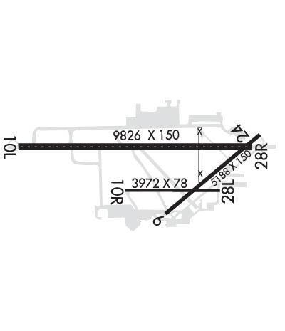
| Lat: N 4306.5 Long: W 07856.8 Elev: 592 Var: +10 Longest Runway: 9826 | ||
| Clr Del: 119.25 Dept. ATIS: 120.8 Arr. ATIS: 120.8 Ground: 125.3 Tower: 118.5 | ||
| ||||||
| ||||||
|
| Rwy | Rwy | |||||||
| 5188x150 | 5188' | 5188x150 | 5188' | |||||
| 9826x150 | 9126' | 9826x150 | 9826' | 110.10 - 280° | ||||
| Runway ID | Single Wheel | Double Wheel | Double Tandem Wheel | Dual Double Wheel |
| 06/24 | 120,000 | 250,000 | 462,000 | N/A |
| 10/28 | 120,000 | 240,000 | 447,000 | 957,000 |
| These numbers are Advisory and are not limits. The Airport Manager should have more accurate Weight Limits | ||||
 Airport Diagram might not be current. | |
| Facility Name: | NIAGARA FALLS INTL |
| City Name: | NIAGARA FALLS |
| County: | NIAGARA |
| State abbrev: | NY |
| State Name: | NEW YORK |
| Ownership: | PUBLICLY OWNED |
| Use: | OPEN TO THE PUBLIC |
| Owner's Name: | NIAGARA FRONTIER T A |
| Address: | 181 ELLICOTT ST, PO BOX 5008 |
| BUFFALO, NY 14205 | |
| Owner's Phone: | 716-855-7300 |
| Manager's Name: | MR. JAMES CELESTE |
| Address: | 2035 NIAGARA FALLS BLVD |
| NIAGARA FALLS, NY 14304 | |
| Phone: | (716) 297-4494 |
| FAA Region: | EASTERN |
| FAA Field Office: | NYC |
| Date | Sunrise | Sunset |
|---|---|---|
| 04/23/26 Thursday | 6:21 | 20:08 |
| 04/24/26 Friday | 6:20 | 20:09 |
| 04/25/26 Saturday | 6:18 | 20:10 |
| 04/26/26 Sunday | 6:17 | 20:11 |
| 04/27/26 Monday | 6:15 | 20:12 |
| 04/28/26 Tuesday | 6:14 | 20:13 |
| 04/29/26 Wednesday | 6:13 | 20:14 |
| 04/30/26 Thursday | 6:11 | 20:16 |
| 05/01/26 Friday | 6:10 | 20:17 |
| 05/02/26 Saturday | 6:08 | 20:18 |
| 05/03/26 Sunday | 6:07 | 20:19 |
| 05/04/26 Monday | 6:06 | 20:20 |
| 05/05/26 Tuesday | 6:04 | 20:21 |
| 05/06/26 Wednesday | 6:03 | 20:22 |
| Airport Attendance Schedule | CONTINUOUS |
| Airport Status | OPERATIONAL (This Status can change at any time - please check NOTAMS) |
| Airport Lighting Schedule | WHEN ATCT CLSD ACTVT MALSR RWY 28; REIL RWY 06, 24; CNTRLN RWY 10/28; PAPI RWY 06, 24, 10; HIRL RWY 10/28; MIRL RWY 06/24; TWY LGTS - CTAF |
| Airport Storage Available | Tie Downs |
| Extra Services Available | Air Freight, Cargo Handling, Charter, Flight Instruction, Aircraft Rental, Aircraft Sales |
| Wind Indicator | YES - (lighted) |
| Control Tower | YES |
| CTAF Frequency | 118.500 |
| Unicom Frequency | 122.950 |
| Rotating Beacon Color | WG |
| Segmented Circle | NO |
| Landing Fee | YES; PARKING FEE. |
| Airport Inspected | FEDERAL - performed by FAA AIRPORTS FIELD PERSONNEL |
| Inspection Date | 08/24/2023 |
| Type of Fuel Available | Grade 100LL, JET A (freeze point -40C), JET A |
| Airframe Repair Service | MINOR |
| Power Plant Repair Service | MINOR |
| Latitude | N4306.5 |
| Longitude | W07856.8 (ESTIMATED) |
| Arpt Elevation | 592ft (SURVEYED) |
| Magnetic Variation | 10W |
| 4 miles E | of NIAGARA FALLS |
| Traffic Pattern Altitude | |
| Sectional Chart | DETROIT |
| Operations (Reported) | Yearly | Avg. Daily |
|---|---|---|
| General Aviation Transient | 0 | 0 |
| General Aviation Local | 0 | 0 |
| Air Taxi | 0 | 0 |
| Commerical | 0 | 0 |
| Commuter | 0 | 0 |
| Military | 0 | 0 |
| Aircraft based on Field | |
|---|---|
| General Aviation Singles | 0 |
| General Aviation Multi | 0 |
| Jet Aircraft | 0 |
| General Aviation Helicopters | 0 |
| Military Aircraft | 0 |
| Gliders | 0 |
| Ultralights | 0 |
| FSS on field | NO |
| FSS tie-in | BUFFALO |
| FSS Phone | 1-800-WX-BRIEF |
| Who issues Notams | IAG |
| Notam D service at airport | YES |
| ARTCC Name | CLEVELAND |
| Airport Certification | AIRPORT RECEIVING SCHEDULED AIR CARRIER SERVICE FROM CARRIERS CERTIFICATED BY THE CIVIL AERONAUTICS BOARD; ARFF INDEX E EQUIPMENT COVERAGE PROVIDED. |
| Aircraft Rescue & Firefighting Index | AIRPORT HAS A CERTIFICATE UNDER CFR PART 139 |
| Airport of Entry | No |
| Custom Landing Rights | YES |
| Joint Civil/Military | No |
| Military Landing rights | YES |
| NATIONAL PLAN OF INTEGRATED AIRPORT SYSTEMS (NPIAS) |
| GRANT AGREEMENTS UNDER FAAP/ADAP/AIP |
| SURPLUS PROPERTY AGREEMENT UNDER PUBLIC LAW 289 |
| SURPLUS PROPERTY AGREEMENT UNDER REGULATION 16-WAA |
| ASSURANCES PURSUANT TO TITLE VI, CIVIL RIGHTS ACT OF 1964 |
| AGREEMENT UNDER DLAND OR DCLA HAS EXPIRED. |
| EXTSV ACFT ACTIVITY OPERATING INVOF US/CANADIAN FALLS ALL ALTS. |
| BEARING STRENGTH RWY 06/24: ST110 TT145 SBTT281 TDT415 TRT252. |
| JASU: 2(A/M32A-86) 1(AM32A-60) 1(MA-1A). |
| FUEL: J8, A++ (MIL). |
| FLUID: SP. |
| OIL: O-148(MIL). |
| MISC: LOCAL MISSION AIRCRAFT HAVE PRIORITY FOR DEICING; MILITARY SIDE ONLY ACFT DE-ICING LIMITED TO KC-135R ONLY. |
| MILITARY: MISC: FOR CURRENT MIL RWY CONDITION READING (RCR) CALL OR CTC 914 ARW COMD POST OR 914TH ARW AFLD MANAGEMENT. |
| PPR CTC AFLD MGT DSN: 238-2176, C716-236-2176. AFLD MGMT RQR 48 HR ADVANCE NOTICE FOR PPR AND WILL ARRANGE U.S. CUSTOMS IF NEEDED. U.S. CUSTOMS NOT ON STATION. |
| AFLD MGMT DOES NOT ISSUE OR STORE COMSEC, FOR COMSEC STORAGE CTC COMMAND POST DSN 238-2150, C716-236-2150. |
| RWY 28 1000 FT X 150 FT BLAST PAD. |
| MILITARY: AFRC: AIRFIELD OPS SVC 1200-0400Z++ MON-FRI EXC HOL. NSTD OPS APN MRKS IDENTIFYING PRKG ROW AND PRKG LCTN. NSTD MAIN APN MRK EAST SIDE, PRK STOP BAR AND ACFT GND EQPT (AGE) BOX. CSTMS/AG/IMG SVC NOT LCTD ON NIAGARA FALLS ARS. SVC AVBL H24. OPS APRON WEST STANCHION LIGHTS UNSVC. USE CAUTION DUR NGT TIME OPS. |
| INTXN DEPS RWY 24 AT TWY D1 ARE NA. |
| CAUTION: HEAVY CONCENTRATIONS OF GULLS-BLACKBIRDS-STARLINGS UP TO 5000 AGL ON & INVOF ARPT. BASH PHASE II OPERATIONS AT KIAG MAR-MAY AND SEP-NOV. |
| TWY A, A1, A2, A3, M & L NON-MOV AREAS. |
| PILOTS ARE REMINDED TO REVIEW ARPT HOTSPOT INFO BFR TXG FOR DEP & BFR LNDG. SEE TPP ARPT DIAGRAM AND CHART SUPPL SXN ON HOTSPOTS FOR ADDNL INFO. |
| FOR CD WHEN ATCT CLSD CTC BUFFALO ATCT ON FREQ OR 716-626-6920. |
| PAJA OPNS SR-SS. CALL AMGR FOR MORE INFO. |
| TWY D3 RSTRD TO 12500 LBS OR LESS. |
| ALL MIL ACFT ONLY OPNS RESTRICTED DURING BIRD WATCH CONDITIONS. MODERATE - TKOF & LDG PERMISSION ONLY WNEN DEP/ARR RTE AVOIDS IDENTIFIED BIRD ACTIVITY; NO LCL IFR/VFR TFC PAT ACTIVITY. SEVERE - TKOF & LDG PHOHIBITED WO OG/CC APPROVAL; CTC COMMAND POST FOR CURRENT BIRD WATCH CONDITIONS. |
| ALL MIL ACFT ONLY MINIMAL CLASSIFIED MATERIALS AVBL; AIRCREWS SHOULD ARRIVE WITH APPROPRIATE AMOUNT TO COMPLETE THEIR MISSION. |
| RWY 10/2 8 RWY 28 ROLLOUT END OF RWY- LAST 900 FT NOT GROOVED. |
| RWY 06/2 4 PCR VALUE: 2540/F/B/X/T |
| RWY 10/2 8 PCR VALUE: 4110/F/B/X/T |
Airport Communications & Frequencies:
| ||||||||||||||||||||||||||||||||||
| Runway: 06 | Runway: 24 | ||
| Mag heading: | 60° | Mag heading: | 240° |
| Rwy Slope: | .15% Up | Rwy Slope: | -.15% Down |
| Approach: | Approach: | ||
| Pattern: | Left Traffic | Pattern: | Left Traffic |
| Markings: | NONPRECISION INSTRUMENT | Markings: | NONPRECISION INSTRUMENT |
| Marking Condition: | GOOD | Marking Condition: | GOOD |
| Arresting Dev: | Arresting Dev: | ||
| Lat & Long: | N4306.1 W07856.7 | Lat. & Long.: | N4306.7 W07855.8 |
| Elev: | 584.3 ft. MSL | Elev: | 592.2 ft. MSL |
| TCH: | 45 ft. AGL | TCH: | 48 ft. AGL |
| Visual Glide Path: | 3.00 degrees | Visual Glide Path: | 3.00 degrees |
| Displaced Threshold: | No | Displaced Threshold: | No |
| Touchdown Zone: | YES | Touchdown Zone: | YES |
| Touchdown Elev.: | 585.8 feet | Touchdown Elev.: | 592.3 feet |
| Visual Glide Slope: | 4-Light PAPI on LEFT side of Runway | Visual Glide Slope: | 4-Light PAPI on LEFT side of Runway |
| RVR Equipment: | RVR Equipment: | ||
| RVV Equipment: | NO | RVV Equipment: | NO |
| Approach Lights: | Approach Lights: | ||
| REIL: | YES | REIL: | YES |
| Centerline Lights: | NO | Centerline Lights: | NO |
| Touchdown lights: | NO | Touchdown lights: | NO |
| Runway Category: | Runway with a Non-precision Approach having visibility minimums greater than 3/4 mile | Runway Category: | Runway with a Non-precision Approach having visibility minimums greater than 3/4 mile |
| Declared Distances: | TORA:5188' TODA:5188' ASDA:5188' LDA:5188' | Declared Distances: | TORA:5188' TODA:5188' ASDA:5108' LDA:5108' |
| Obstructions: | TREE | Obstructions: | TREE |
| Marked: | NOT Marked/Lighted | Marked: | NOT Marked/Lighted |
| Clearance slope: | 11:1 | Clearance slope: | 26:1 |
| Obstruction height: | 46 feet AGL | Obstruction height: | 59 feet AGL |
| Dist. from runway: | 740 feet | Dist. from runway: | 1750 feet |
| Centerline offset: | 290 right of centerline | Centerline offset: | 320 feet right of centerline |
| Comments: | Comments: |
| Runway: 10 | Runway: 28 | ||
| Mag heading: | 100° | Mag heading: | 280° |
| Rwy Slope: | .00% Down | Rwy Slope: | .00% Up |
| Approach: | Approach: | ILS | |
| Pattern: | Left Traffic | Pattern: | Left Traffic |
| Markings: | PRECISION INSTRUMENT | Markings: | PRECISION INSTRUMENT |
| Marking Condition: | GOOD | Marking Condition: | GOOD |
| Arresting Dev: | Arresting Dev: | ||
| Lat & Long: | N4306.6 W07858.1 | Lat. & Long.: | N4306.6 W07855.9 |
| Elev: | 588.2 ft. MSL | Elev: | 587.9 ft. MSL |
| TCH: | 53 ft. AGL | TCH: | 67 ft. AGL |
| Visual Glide Path: | 2.89 degrees | Visual Glide Path: | 2.50 degrees |
| Displaced Threshold: | 700 feet | Displaced Threshold: | No |
| Touchdown Zone: | YES | Touchdown Zone: | YES |
| Touchdown Elev.: | 588.8 feet | Touchdown Elev.: | 588.3 feet |
| Visual Glide Slope: | 4-Light PAPI on LEFT side of Runway | Visual Glide Slope: | 4-Light PAPI on LEFT side of Runway |
| RVR Equipment: | ROLLOUT | RVR Equipment: | TOUCHDOWN |
| RVV Equipment: | NO | RVV Equipment: | YES |
| Approach Lights: | Approach Lights: | MALSR - 1,400 foot medium intensity approach lighting system with runway alignment indicator lights | |
| REIL: | NO | REIL: | NO |
| Centerline Lights: | YES | Centerline Lights: | YES |
| Touchdown lights: | NO | Touchdown lights: | YES |
| Runway Category: | Runway with a Non-precision Approach having visibility minimums greater than 3/4 mile | Runway Category: | Precision Instrument Runway |
| Declared Distances: | TORA:9829' TODA:10829' ASDA:9829' LDA:9129' | Declared Distances: | TORA:9829' TODA:10529' ASDA:9129' LDA:9129' |
| Obstructions: | TREE | Obstructions: | TREE |
| Marked: | NOT Marked/Lighted | Marked: | NOT Marked/Lighted |
| Clearance slope: | 12:1; APCH RATIO 29:1 TO DTHR. | Clearance slope: | 33:1 |
| Obstruction height: | 52 feet AGL | Obstruction height: | 37 feet AGL |
| Dist. from runway: | 840 feet | Dist. from runway: | 1425 feet |
| Centerline offset: | 480 right of centerline | Centerline offset: | 400 feet left of centerline |
| Comments: | Comments: |
Thanks for using FltPlan.com
all rights reserved © 1999-2026 by Flight Plan LLC
