
| GREENSBURG MUNICIPAL GREENSBURG IN |
| |
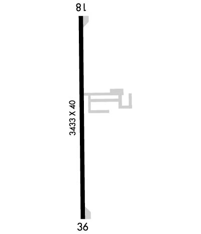
| Lat: N 3919.6 Long: W 08531.4 Elev: 912 Var: +04 Longest Runway: 3433 | ||
| CTAF: 122.9 | ||
| ||||||||||||||||||||||||||||||||||||||||||||
| ||||||||||||||||||||||||||||||||||||||||||||
| Rwy | Rwy | |||||||
| 3433x40 | 2933' | 3433x40 | 3333' | |||||
| Runway ID | Single Wheel | Double Wheel | Double Tandem Wheel | Dual Double Wheel |
| 18/36 | N/A | N/A | N/A | N/A |
| These numbers are Advisory and are not limits. The Airport Manager should have more accurate Weight Limits | ||||
 Airport Diagram might not be current. | |
| Facility Name: | GREENSBURG MUNI |
| City Name: | GREENSBURG |
| County: | DECATUR |
| State abbrev: | IN |
| State Name: | INDIANA |
| Ownership: | PUBLICLY OWNED |
| Use: | OPEN TO THE PUBLIC |
| Owner's Name: | GREENSBURG-DECATUR CO BOAC |
| Address: | 915 S. 200 W |
| GREENSBURG, IN 47240 | |
| Owner's Phone: | (812) 662-6224 |
| Manager's Name: | JERRY SCHEIDLER |
| Address: | 3551 N. OLD US 421 |
| GREENSBURG, IN 47240 | |
| Phone: | 812-593-1677 |
| FAA Region: | GREAT LAKES |
| FAA Field Office: | CHI |
| Date | Sunrise | Sunset |
|---|---|---|
| 09/24/21 Friday | 7:31 | 19:36 |
| 09/25/21 Saturday | 7:32 | 19:35 |
| 09/26/21 Sunday | 7:33 | 19:33 |
| 09/27/21 Monday | 7:34 | 19:31 |
| 09/28/21 Tuesday | 7:35 | 19:30 |
| 09/29/21 Wednesday | 7:36 | 19:28 |
| 09/30/21 Thursday | 7:37 | 19:27 |
| 10/01/21 Friday | 7:38 | 19:25 |
| 10/02/21 Saturday | 7:39 | 19:23 |
| 10/03/21 Sunday | 7:40 | 19:22 |
| 10/04/21 Monday | 7:41 | 19:20 |
| 10/05/21 Tuesday | 7:42 | 19:19 |
| 10/06/21 Wednesday | 7:43 | 19:17 |
| 10/07/21 Thursday | 7:44 | 19:16 |
| Airport Attendance Schedule | MON-FRI ON CALL; ATTENDANT - AMGR. |
| Airport Status | OPERATIONAL (This Status can change at any time - please check NOTAMS) |
| Airport Lighting Schedule | ACTVT VASI RWY 18 & 36; MIRL RWY 18/36 - CTAF. |
| Airport Storage Available | Tie Downs |
| Extra Services Available | NONE |
| Wind Indicator | YES - (lighted) |
| Control Tower | NO |
| CTAF Frequency | 122.900 |
| Unicom Frequency | |
| Rotating Beacon Color | CLEAR-GREEN (Light Land Airport) |
| Segmented Circle | NO |
| Landing Fee | NO |
| Airport Inspected | STATE - performed by STATE AERONAUTICAL PERSONNEL |
| Inspection Date | 02/03/2021 |
| Type of Fuel Available | Grade 100LL, JET A (freeze point -40C) |
| Airframe Repair Service | MINOR |
| Power Plant Repair Service | MINOR |
| Latitude | N3919.6 |
| Longitude | W08531.4 (ESTIMATED) |
| Arpt Elevation | 912ft (SURVEYED) |
| Magnetic Variation | 04W |
| 2 miles SW | of GREENSBURG |
| Traffic Pattern Altitude | |
| Sectional Chart | ST LOUIS |
| Operations (Reported) | Yearly | Avg. Daily |
|---|---|---|
| General Aviation Transient | 630 | 2 |
| General Aviation Local | 2835 | 8 |
| Air Taxi | 35 | 0 |
| Commerical | 0 | 0 |
| Commuter | 0 | 0 |
| Military | 0 | 0 |
| Aircraft based on Field | |
|---|---|
| General Aviation Singles | 34 |
| General Aviation Multi | 0 |
| Jet Aircraft | 0 |
| General Aviation Helicopters | 0 |
| Military Aircraft | 0 |
| Gliders | 0 |
| Ultralights | 0 |
| FSS on field | NO |
| FSS tie-in | TERRE HAUTE |
| FSS Phone | 1-800-WX-BRIEF |
| Who issues Notams | HUF |
| Notam D service at airport | YES |
| ARTCC Name | INDIANAPOLIS |
| Airport Certification | |
| Aircraft Rescue & Firefighting Index | None |
| Airport of Entry | No |
| Custom Landing Rights | No |
| Joint Civil/Military | No |
| Military Landing rights | No |
| NATIONAL PLAN OF INTEGRATED AIRPORT SYSTEMS (NPIAS) |
| THIS AIRPORT HAS BEEN SURVEYED BY THE NATIONAL GEODETIC SURVEY. |
| FOR CD CTC INDIANAPOLIS APCH AT 317-227-5743. |
Airport Communications & Frequencies:
| |||||||||||
| Runway: 18 | Runway: 36 | ||
| Mag heading: | 184° | Mag heading: | 4° |
| Rwy Slope: | -.20% Down | Rwy Slope: | .20% Up |
| Approach: | Approach: | ||
| Pattern: | Left Traffic | Pattern: | Left Traffic |
| Markings: | BASIC | Markings: | BASIC |
| Marking Condition: | FAIR | Marking Condition: | FAIR |
| Arresting Dev: | Arresting Dev: | ||
| Lat & Long: | N3919.9 W08531.4 | Lat. & Long.: | N3919.3 W08531.3 |
| Elev: | 912.0 ft. MSL | Elev: | 905.0 ft. MSL |
| TCH: | 23 ft. AGL | TCH: | 22 ft. AGL |
| Visual Glide Path: | 3.25 degrees | Visual Glide Path: | 3.25 degrees |
| Displaced Threshold: | 500 feet | Displaced Threshold: | 100 feet |
| Touchdown Zone: | YES | Touchdown Zone: | YES |
| Touchdown Elev.: | 912.0 feet | Touchdown Elev.: | 912.0 feet |
| Visual Glide Slope: | 2-Box VASI on LEFT side of Runway | Visual Glide Slope: | 2-Box VASI on LEFT side of Runway |
| RVR Equipment: | RVR Equipment: | ||
| RVV Equipment: | NO | RVV Equipment: | NO |
| Approach Lights: | Approach Lights: | ||
| REIL: | NO | REIL: | NO |
| Centerline Lights: | NO | Centerline Lights: | NO |
| Touchdown lights: | NO | Touchdown lights: | NO |
| Runway Category: | Runway with a Visual Approach | Runway Category: | Runway with a Non-precision Approach |
| Declared Distances: | Declared Distances: | ||
| Obstructions: | ROAD | Obstructions: | TREES |
| Marked: | NOT Marked/Lighted | Marked: | NOT Marked/Lighted |
| Clearance slope: | APCH SLOPE TO DSPLCD THLD 20:1 | Clearance slope: | APCH SLOPE TO DSPLCD THLD 0:1 DUE TO 60 FT TREES 170 FT L |
| Obstruction height: | 20 feet AGL | Obstruction height: | 57 feet AGL |
| Dist. from runway: | 201 feet | Dist. from runway: | 201 feet |
| Centerline offset: | 130 right of centerline | Centerline offset: | 200 feet left of centerline |
| Comments: | SCATTERED BRUSH 100 FT FM RWY. | Comments: |
Thanks for using FltPlan.com
all rights reserved © 1999-2021 by Flight Plan LLC
