
| CARROLL COUNTY HUNTINGDON TN |
| |
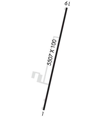
| Lat: N 3605.4 Long: W 08827.8 Elev: 497 Var: +02 Longest Runway: 5507 | ||
| AWOS: 133.27 CTAF: 122.8 | ||
| ||||||
| ||||||
|
| Rwy | Rwy | |||||||
| 5507x100 | 5507' | 5507x100 | 5507' | |||||
| Runway ID | Single Wheel | Double Wheel | Double Tandem Wheel | Dual Double Wheel |
| 01/19 | 48,000 | 66,000 | N/A | N/A |
| These numbers are Advisory and are not limits. The Airport Manager should have more accurate Weight Limits | ||||
 Airport Diagram might not be current. | |
| Facility Name: | CARROLL COUNTY |
| City Name: | HUNTINGDON |
| County: | CARROLL |
| State abbrev: | TN |
| State Name: | TENNESSEE |
| Ownership: | PUBLICLY OWNED |
| Use: | OPEN TO THE PUBLIC |
| Owner's Name: | CARROLL COUNTY, TENNESSEE |
| Address: | 625 HIGH STREET, SUITE 101 |
| HUNTINGDON, TN 38344 | |
| Owner's Phone: | 731-986-1936 |
| Manager's Name: | TOMMY SWOR |
| Address: | 535 AIRPORT LANE |
| MCKENZIE, TN 38201 | |
| Phone: | 731-352-7278 |
| FAA Region: | SOUTHERN |
| FAA Field Office: | MEM |
| Date | Sunrise | Sunset |
|---|---|---|
| 09/24/21 Friday | 6:43 | 18:48 |
| 09/25/21 Saturday | 6:44 | 18:47 |
| 09/26/21 Sunday | 6:45 | 18:45 |
| 09/27/21 Monday | 6:46 | 18:44 |
| 09/28/21 Tuesday | 6:46 | 18:42 |
| 09/29/21 Wednesday | 6:47 | 18:41 |
| 09/30/21 Thursday | 6:48 | 18:39 |
| 10/01/21 Friday | 6:49 | 18:38 |
| 10/02/21 Saturday | 6:50 | 18:36 |
| 10/03/21 Sunday | 6:50 | 18:35 |
| 10/04/21 Monday | 6:51 | 18:33 |
| 10/05/21 Tuesday | 6:52 | 18:32 |
| 10/06/21 Wednesday | 6:53 | 18:31 |
| 10/07/21 Thursday | 6:54 | 18:29 |
| Airport Attendance Schedule | MON-SAT 0800-1700, SUN 1300-1700; FOR SERVICE AFTER HRS CALL 731-641-0123. |
| Airport Status | OPERATIONAL (This Status can change at any time - please check NOTAMS) |
| Airport Lighting Schedule | MIRL RY 01/19 PRESET MED INTST; TO INCREASE INTST & ACTVT REIL RYS 01 & 19 - CTAF. |
| Airport Storage Available | Tie Downs, Hanger |
| Extra Services Available | Flight Instruction, Aircraft Rental, Aircraft Sales |
| Wind Indicator | YES - (lighted) |
| Control Tower | NO |
| CTAF Frequency | 122.800 |
| Unicom Frequency | 122.800 |
| Rotating Beacon Color | CLEAR-GREEN (Light Land Airport) |
| Segmented Circle | YES |
| Landing Fee |
| Airport Inspected | STATE - performed by STATE AERONAUTICAL PERSONNEL |
| Inspection Date | 10/15/2020 |
| Type of Fuel Available | Grade 100LL, JET A |
| Airframe Repair Service | MAJOR |
| Power Plant Repair Service | MAJOR |
| Latitude | N3605.4 |
| Longitude | W08827.8 (ESTIMATED) |
| Arpt Elevation | 496ft (SURVEYED) |
| Magnetic Variation | 02W |
| 4 miles NW | of HUNTINGDON |
| Traffic Pattern Altitude | |
| Sectional Chart | MEMPHIS |
| Operations (Reported) | Yearly | Avg. Daily |
|---|---|---|
| General Aviation Transient | 3500 | 10 |
| General Aviation Local | 10650 | 29 |
| Air Taxi | 50 | 0 |
| Commerical | 0 | 0 |
| Commuter | 0 | 0 |
| Military | 50 | 0 |
| Aircraft based on Field | |
|---|---|
| General Aviation Singles | 12 |
| General Aviation Multi | 1 |
| Jet Aircraft | 1 |
| General Aviation Helicopters | 1 |
| Military Aircraft | 0 |
| Gliders | 0 |
| Ultralights | 0 |
| FSS on field | NO |
| FSS tie-in | JACKSON |
| FSS Phone | 1-800-WX-BRIEF |
| Who issues Notams | MKL |
| Notam D service at airport | YES |
| ARTCC Name | MEMPHIS |
| Airport Certification | |
| Aircraft Rescue & Firefighting Index | None |
| Airport of Entry | No |
| Custom Landing Rights | No |
| Joint Civil/Military | No |
| Military Landing rights | No |
| NATIONAL PLAN OF INTEGRATED AIRPORT SYSTEMS (NPIAS) |
| FOR CD CTC MEMPHIS ARTCC AT 901-368-8453/8449. |
Airport Communications & Frequencies:
| |||||||||
| Runway: 01 | Runway: 19 | ||
| Mag heading: | 14° | Mag heading: | 194° |
| Rwy Slope: | .02% Up | Rwy Slope: | -.02% Down |
| Approach: | Approach: | ||
| Pattern: | Left Traffic | Pattern: | Left Traffic |
| Markings: | NONPRECISION INSTRUMENT | Markings: | NONPRECISION INSTRUMENT |
| Marking Condition: | GOOD | Marking Condition: | FAIR |
| Arresting Dev: | Arresting Dev: | ||
| Lat & Long: | N3604.9 W08827.9 | Lat. & Long.: | N3605.8 W08827.7 |
| Elev: | 495.3 ft. MSL | Elev: | 496.6 ft. MSL |
| TCH: | 26 ft. AGL | TCH: | 28 ft. AGL |
| Visual Glide Path: | 3.00 degrees | Visual Glide Path: | 4.00 degrees |
| Displaced Threshold: | No | Displaced Threshold: | No |
| Touchdown Zone: | YES | Touchdown Zone: | YES |
| Touchdown Elev.: | 495.3 feet | Touchdown Elev.: | 496.6 feet |
| Visual Glide Slope: | 4-Light PAPI on LEFT side of Runway; RWY 1 UNUSABLE BEYOND 9 DEG RIGHT OF RCL | Visual Glide Slope: | 4-Light PAPI on LEFT side of Runway; RWY 19 UNUSABLE BEYOND 9 DEG LEFT OF RCL RWY 19 UNUSABLE BEYOND 8 DEG RIGHT OF RCL |
| RVR Equipment: | RVR Equipment: | ||
| RVV Equipment: | NO | RVV Equipment: | NO |
| Approach Lights: | Approach Lights: | ||
| REIL: | YES | REIL: | YES |
| Centerline Lights: | NO | Centerline Lights: | NO |
| Touchdown lights: | NO | Touchdown lights: | NO |
| Runway Category: | Runway with a Non-precision Approach having visibility minimums greater than 3/4 mile | Runway Category: | Runway with a Non-precision Approach having visibility minimums greater than 3/4 mile |
| Declared Distances: | Declared Distances: | ||
| Obstructions: | TREES | Obstructions: | TREES |
| Marked: | NOT Marked/Lighted | Marked: | NOT Marked/Lighted |
| Clearance slope: | 27:1 | Clearance slope: | 17:1 |
| Obstruction height: | 64 feet AGL | Obstruction height: | 82 feet AGL |
| Dist. from runway: | 1977 feet | Dist. from runway: | 1613 feet |
| Centerline offset: | 693 right of centerline | Centerline offset: | 324 feet left of centerline |
| Comments: | Comments: |
Thanks for using FltPlan.com
all rights reserved © 1999-2021 by Flight Plan LLC
