
| EAST HAMPTON EAST HAMPTON NY |
| |
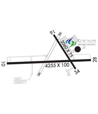
| Lat: N 4057.6 Long: W 07215.1 Elev: 55 Var: +13 Longest Runway: 4255 | ||
| Clr Del: 118.95 AWOS: 118.07 Ground: 121.9 Tower: 125.22 | ||
| |||||||||||||||||||||||||||||||||||||||||||||||||||||||||||||||||||||
| |||||||||||||||||||||||||||||||||||||||||||||||||||||||||||||||||||||
| |||||||||||||||||||||||||||||||||||||||||||||||||||||||||||||||||||||
| |||||||||||||||||||||||||||||||||||||||||||||||||||||||||||||||||||||
| Rwy | Rwy | |||||||
| 4255x100 | 4255' | 4255x100 | 4255' | |||||
| 2060x75 | 2060' | 2060x75 | 2060' | |||||
| Runway ID | Single Wheel | Double Wheel | Double Tandem Wheel | Dual Double Wheel |
| 10/28 | 78,000 | N/A | N/A | N/A |
| 16/34 | 8,000 | N/A | N/A | N/A |
| These numbers are Advisory and are not limits. The Airport Manager should have more accurate Weight Limits | ||||
 Airport Diagram might not be current. | |
| Facility Name: | EAST HAMPTON |
| City Name: | EAST HAMPTON |
| County: | SUFFOLK |
| State abbrev: | NY |
| State Name: | NEW YORK |
| Ownership: | PUBLICLY OWNED |
| Use: | OPEN TO THE PUBLIC |
| Owner's Name: | TOWN OF EAST HAMPTON |
| Address: | 159 PANTIGO RD |
| EAST HAMPTON, NY 11937 | |
| Owner's Phone: | 631-324-4140 |
| Manager's Name: | JAMES BRUNDIGE |
| Address: | 200 DANIELS HOLE RD. |
| WAINSCOTT, NY 11975 | |
| Phone: | 631-537-1130 X 5 |
| FAA Region: | EASTERN |
| FAA Field Office: | NYC |

| Date | Sunrise | Sunset |
|---|---|---|
| 09/24/21 Friday | 6:38 | 18:43 |
| 09/25/21 Saturday | 6:39 | 18:42 |
| 09/26/21 Sunday | 6:40 | 18:40 |
| 09/27/21 Monday | 6:41 | 18:38 |
| 09/28/21 Tuesday | 6:42 | 18:36 |
| 09/29/21 Wednesday | 6:43 | 18:35 |
| 09/30/21 Thursday | 6:44 | 18:33 |
| 10/01/21 Friday | 6:45 | 18:31 |
| 10/02/21 Saturday | 6:46 | 18:30 |
| 10/03/21 Sunday | 6:47 | 18:28 |
| 10/04/21 Monday | 6:48 | 18:26 |
| 10/05/21 Tuesday | 6:49 | 18:25 |
| 10/06/21 Wednesday | 6:50 | 18:23 |
| 10/07/21 Thursday | 6:52 | 18:22 |
| Airport Attendance Schedule | |
| Airport Status | OPERATIONAL (This Status can change at any time - please check NOTAMS) |
| Airport Lighting Schedule | ACTVT REIL RWY 10 & 28; PAPI RWY 10 & 28; MIRL RWY 10/28 - CTAF. (PAPI & REIL 7 CLICKS CTAF). |
| Airport Storage Available | Tie Downs, Hanger |
| Extra Services Available | Charter, Flight Instruction, Aircraft Sales |
| Wind Indicator | YES - (lighted) |
| Control Tower | YES |
| CTAF Frequency | 125.225 |
| Unicom Frequency | |
| Rotating Beacon Color | CLEAR-GREEN (Light Land Airport) |
| Segmented Circle | YES |
| Landing Fee | YES; LDG FEE FOR ALL TSNT ACFT TO INCL TGL OPNS CTC 1-888-588-0028. |
| Airport Inspected | STATE - performed by STATE AERONAUTICAL PERSONNEL |
| Inspection Date | 06/18/2019 |
| Type of Fuel Available | Grade 100LL, JET A (freeze point -40C) |
| Airframe Repair Service | MAJOR |
| Power Plant Repair Service | MAJOR |
| Latitude | N4057.6 |
| Longitude | W07215.1 (ESTIMATED) |
| Arpt Elevation | 54ft (SURVEYED) |
| Magnetic Variation | 13W |
| 3 miles W | of EAST HAMPTON |
| Traffic Pattern Altitude | |
| Sectional Chart | NEW YORK |
| Operations (Reported) | Yearly | Avg. Daily |
|---|---|---|
| General Aviation Transient | 19806 | 54 |
| General Aviation Local | 5404 | 15 |
| Air Taxi | 0 | 0 |
| Commerical | 0 | 0 |
| Commuter | 0 | 0 |
| Military | 50 | 0 |
| Aircraft based on Field | |
|---|---|
| General Aviation Singles | 48 |
| General Aviation Multi | 2 |
| Jet Aircraft | 2 |
| General Aviation Helicopters | 2 |
| Military Aircraft | 0 |
| Gliders | 0 |
| Ultralights | 0 |
| FSS on field | NO |
| FSS tie-in | NEW YORK |
| FSS Phone | 1-800-WX-BRIEF |
| Who issues Notams | HTO |
| Notam D service at airport | YES |
| ARTCC Name | NEW YORK |
| Airport Certification | |
| Aircraft Rescue & Firefighting Index | None |
| Airport of Entry | No |
| Custom Landing Rights | No |
| Joint Civil/Military | No |
| Military Landing rights | YES |
| NATIONAL PLAN OF INTEGRATED AIRPORT SYSTEMS (NPIAS) |
| GRANT AGREEMENTS UNDER FAAP/ADAP/AIP |
| ADVANCE PLANNING AGREEMENT UNDER FAAP |
| ASSURANCES PURSUANT TO TITLE VI, CIVIL RIGHTS ACT OF 1964 |
| DEER ON & INVOF ARPT. |
| FOR CD WHEN ATCT CLSD CTC NEW YORK APCH AT 516-683-2449 OR 118.95. |
| NIGHTTIME CURFEW: 11:00 PM-7:00 AM. |
| (A89) FOR LOCAL CALL TO FSS DIAL 737-1000. |
| NOISE ABATEMENT AND RAMP PROC IN EFCT. GO TO WWW.EHAMPTONNY.GOV/311/AIRPORT OR CTC ARP MGR. |
| TWR FREQ: 125.225. CTAF FREQ125.225 (1200-1159Z, ATCT OPRS ONE WEEK BFR MEMORIAL DAY TO ONE WEEK AFT LABOR DAY. OTHER TIMES BY NOTAM). |
| AIRSPACE: CLASS D SER 1200Z-1159Z. |
Airport Communications & Frequencies:
| ||||||||||||||||||
| Runway: 10 | Runway: 28 | ||
| Mag heading: | 102° | Mag heading: | 282° |
| Rwy Slope: | -.58% Down | Rwy Slope: | .58% Up |
| Approach: | Approach: | ||
| Pattern: | Left Traffic | Pattern: | Left Traffic |
| Markings: | NONPRECISION INSTRUMENT | Markings: | NONPRECISION INSTRUMENT |
| Marking Condition: | GOOD | Marking Condition: | GOOD |
| Arresting Dev: | Arresting Dev: | ||
| Lat & Long: | N4057.5 W07215.6 | Lat. & Long.: | N4057.5 W07214.7 |
| Elev: | 54.9 ft. MSL | Elev: | 30.2 ft. MSL |
| TCH: | 49 ft. AGL | TCH: | 54 ft. AGL |
| Visual Glide Path: | 3.30 degrees | Visual Glide Path: | 3.00 degrees |
| Displaced Threshold: | No | Displaced Threshold: | No |
| Touchdown Zone: | YES | Touchdown Zone: | YES |
| Touchdown Elev.: | 54.9 feet | Touchdown Elev.: | 46.2 feet |
| Visual Glide Slope: | 2-Light PAPI on LEFT side of Runway; VGSI AND RNAV GLIDEPATH NOT COINCIDENT. | Visual Glide Slope: | 2-Light PAPI on RIGHT side of Runway |
| RVR Equipment: | RVR Equipment: | ||
| RVV Equipment: | NO | RVV Equipment: | NO |
| Approach Lights: | Approach Lights: | ||
| REIL: | YES | REIL: | YES |
| Centerline Lights: | NO | Centerline Lights: | NO |
| Touchdown lights: | NO | Touchdown lights: | NO |
| Runway Category: | Runway with a Non-precision Approach | Runway Category: | Runway with a Non-precision Approach |
| Declared Distances: | Declared Distances: | ||
| Obstructions: | TREES | Obstructions: | POLE; +78 FT TREES, 850 FT FM THR BOTH SIDES CTRLN; +15 FT ROAD, 491 FT FM THR BOTH SIDES CTRLN. |
| Marked: | NOT Marked/Lighted | Marked: | NOT Marked/Lighted |
| Clearance slope: | 12:1 | Clearance slope: | 3:1 |
| Obstruction height: | 77 feet AGL | Obstruction height: | 45 feet AGL |
| Dist. from runway: | 1162 feet | Dist. from runway: | 372 feet |
| Centerline offset: | Centerline offset: | 264 feet right of centerline | |
| Comments: | Comments: |
| Runway: 16 | Runway: 34 | ||
| Mag heading: | 162° | Mag heading: | 342° |
| Rwy Slope: | -.53% Down | Rwy Slope: | .53% Up |
| Approach: | Approach: | ||
| Pattern: | Left Traffic | Pattern: | Left Traffic |
| Markings: | BASIC | Markings: | BASIC |
| Marking Condition: | FAIR | Marking Condition: | FAIR |
| Arresting Dev: | Arresting Dev: | ||
| Lat & Long: | N4057.8 W07215.1 | Lat. & Long.: | N4057.5 W07214.9 |
| Elev: | 40.7 ft. MSL | Elev: | 29.8 ft. MSL |
| TCH: | TCH: | ||
| Visual Glide Path: | Visual Glide Path: | ||
| Displaced Threshold: | No | Displaced Threshold: | No |
| Touchdown Zone: | YES | Touchdown Zone: | YES |
| Touchdown Elev.: | 40.7 feet | Touchdown Elev.: | 40.7 feet |
| Visual Glide Slope: | Visual Glide Slope: | ||
| RVR Equipment: | RVR Equipment: | ||
| RVV Equipment: | NO | RVV Equipment: | NO |
| Approach Lights: | Approach Lights: | ||
| REIL: | NO | REIL: | NO |
| Centerline Lights: | NO | Centerline Lights: | NO |
| Touchdown lights: | NO | Touchdown lights: | NO |
| Runway Category: | Runway with a Visual Approach | Runway Category: | Runway with a Visual Approach |
| Declared Distances: | Declared Distances: | ||
| Obstructions: | ROAD | Obstructions: | TREES |
| Marked: | NOT Marked/Lighted | Marked: | NOT Marked/Lighted |
| Clearance slope: | 3:1 | Clearance slope: | 4:1 |
| Obstruction height: | 15 feet AGL | Obstruction height: | 49 feet AGL |
| Dist. from runway: | 245 feet | Dist. from runway: | 398 feet |
| Centerline offset: | Centerline offset: | 138 feet left of centerline | |
| Comments: | Comments: |
Thanks for using FltPlan.com
all rights reserved © 1999-2021 by Flight Plan LLC


