| MANASSAS RGNL/HARRY P. DAVIS WASHINGTON VA |
| |
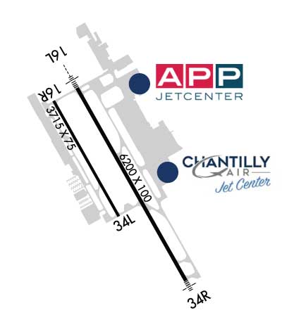
| Lat: N 3843.3 Long: W 07730.9 Elev: 192 Var: +10 Longest Runway: 6200 | ||
| Clr Del: 120.2 TW CLD Dept. ATIS: 125.17 Arr. ATIS: 125.17 AWOS: 125.17 Ground: 121.8 Tower: 133.1 | ||
| |||||||||||||||||||||||||||||||||||||||||||||||||||||||||||||||||||||
| |||||||||||||||||||||||||||||||||||||||||||||||||||||||||||||||||||||
| |||||||||||||||||||||||||||||||||||||||||||||||||||||||||||||||||||||
| |||||||||||||||||||||||||||||||||||||||||||||||||||||||||||||||||||||
| FBOs at nearby airports who want your business: | |||||||||||||||||
| |||||||||||||||||
| Rwy | Rwy | |||||||
| 6200x100 | 6200' | 109.10 - 160° | 6200x100 | 6200' | ||||
| 3715x75 | 3715' | 3715x75 | 3715' | |||||
| Runway ID | Single Wheel | Double Wheel | Double Tandem Wheel | Dual Double Wheel |
| 16L/34R | 50,000 | 140,000 | N/A | N/A |
| 16R/34L | 12,500 | N/A | N/A | N/A |
| These numbers are Advisory and are not limits. The Airport Manager should have more accurate Weight Limits | ||||
 Airport Diagram might not be current. | |
| Facility Name: | MANASSAS RGNL/HARRY P DAVIS FLD |
| City Name: | WASHINGTON |
| County: | PRINCE WILLIAM |
| State abbrev: | DC |
| State Name: | DIST. OF COLUMBIA |
| Ownership: | PUBLICLY OWNED |
| Use: | OPEN TO THE PUBLIC |
| Owner's Name: | CITY OF MANASSAS |
| Address: | 10600 HARRY J. PARRISH BOULEVARD |
| MANASSAS, VA 20110 | |
| Owner's Phone: | 703-361-1882 |
| Manager's Name: | JUAN RIVERA |
| Address: | 10600 HARRY J. PARRISH BOULEVARD |
| MANASSAS, VA 20110 | |
| Phone: | 703-361-1882 |
| FAA Region: | EASTERN |
| FAA Field Office: | DCA |

| Date | Sunrise | Sunset |
|---|---|---|
| 09/24/21 Friday | 6:59 | 19:04 |
| 09/25/21 Saturday | 7:00 | 19:03 |
| 09/26/21 Sunday | 7:01 | 19:01 |
| 09/27/21 Monday | 7:02 | 19:00 |
| 09/28/21 Tuesday | 7:03 | 18:58 |
| 09/29/21 Wednesday | 7:04 | 18:56 |
| 09/30/21 Thursday | 7:05 | 18:55 |
| 10/01/21 Friday | 7:06 | 18:53 |
| 10/02/21 Saturday | 7:07 | 18:52 |
| 10/03/21 Sunday | 7:08 | 18:50 |
| 10/04/21 Monday | 7:08 | 18:49 |
| 10/05/21 Tuesday | 7:09 | 18:47 |
| 10/06/21 Wednesday | 7:10 | 18:45 |
| 10/07/21 Thursday | 7:11 | 18:44 |
| Airport Attendance Schedule | 7 Days A Week 0630-2230 |
| Airport Status | OPERATIONAL (This Status can change at any time - please check NOTAMS) |
| Airport Lighting Schedule | WHEN ATCT CLSD ACTVT HIRL RY 16L/34R, MALSR RY 16L, MALSF RY 34R, MIRL RY 16R/34L, & REILS RY 16R & RY 34L - CTAF. |
| Airport Storage Available | Tie Downs, Hanger |
| Extra Services Available | Avionics, Charter, Flight Instruction, Aircraft Rental, Aircraft Sales |
| Wind Indicator | YES - (lighted) |
| Control Tower | YES |
| CTAF Frequency | 133.100 |
| Unicom Frequency | |
| Rotating Beacon Color | CLEAR-GREEN (Light Land Airport) |
| Segmented Circle | YES |
| Landing Fee | NO |
| Airport Inspected | STATE - performed by STATE AERONAUTICAL PERSONNEL |
| Inspection Date | 08/27/2018 |
| Type of Fuel Available | Grade 100LL, JET A (freeze point -40C) |
| Airframe Repair Service | MAJOR |
| Power Plant Repair Service | MAJOR |
| Latitude | N3843.3 |
| Longitude | W07730.9 (ESTIMATED) |
| Arpt Elevation | 192ft (SURVEYED) |
| Magnetic Variation | 10W |
| 28 miles WSW | of WASHINGTON |
| Traffic Pattern Altitude | TPA - 1200 MSL SINGLE ENGINE & LGT TWIN ACFT; 1500 MSL MED TWIN & TURBOPROP ACFT; 1000 MSL HELICOPTER. |
| Sectional Chart | WASHINGTON |
| Operations (Reported) | Yearly | Avg. Daily |
|---|---|---|
| General Aviation Transient | 58740 | 161 |
| General Aviation Local | 25948 | 71 |
| Air Taxi | 1021 | 3 |
| Commerical | 0 | 0 |
| Commuter | 0 | 0 |
| Military | 1021 | 3 |
| Aircraft based on Field | |
|---|---|
| General Aviation Singles | 261 |
| General Aviation Multi | 39 |
| Jet Aircraft | 24 |
| General Aviation Helicopters | 15 |
| Military Aircraft | 0 |
| Gliders | 0 |
| Ultralights | 0 |
| FSS on field | NO |
| FSS tie-in | LEESBURG |
| FSS Phone | 1-800-WX-BRIEF |
| Who issues Notams | HEF |
| Notam D service at airport | YES |
| ARTCC Name | WASHINGTON |
| Airport Certification | |
| Aircraft Rescue & Firefighting Index | None |
| Airport of Entry | No |
| Custom Landing Rights | YES |
| Joint Civil/Military | No |
| Military Landing rights | YES |
| NATIONAL PLAN OF INTEGRATED AIRPORT SYSTEMS (NPIAS) |
| GRANT AGREEMENTS UNDER FAAP/ADAP/AIP |
| ASSURANCES PURSUANT TO TITLE VI, CIVIL RIGHTS ACT OF 1964 |
| BIRDS & DEER ON & INVOF ARPT. |
| HELICOPTER OPS OVER RESIDENTIAL AREAS BLO 1000 FT SHOULD BE AVOIDED; CTC AMGR 703-361-1882 FOR INFO. |
| US CUSTOMS AVBL MON-SUN 1000-0400Z. CALL COMMAND CENTER 703-661-2800 FOR APNTMT. 24 HR NOTICE RQRD. ALL WKEND FLIGHTS MUST BE ARNGD BFR 1700 LOCAL ON FRI BFR. |
| FOR CD WHEN ATCT IS CLSD CTC POTOMAC APCH AT 866-709-4993. |
| TRML APN FOR TSNT AND US CUST PRKG. |
Airport Communications & Frequencies:
| ||||||||||||||||||||||||
| Runway: 16L | Runway: 34R | ||
| Mag heading: | 161° | Mag heading: | 341° |
| Rwy Slope: | -.24% Down | Rwy Slope: | .24% Up |
| Approach: | LOC/GS | Approach: | |
| Pattern: | Left Traffic | Pattern: | Right Traffic |
| Markings: | PRECISION INSTRUMENT | Markings: | NONPRECISION INSTRUMENT |
| Marking Condition: | GOOD | Marking Condition: | GOOD |
| Arresting Dev: | Arresting Dev: | ||
| Lat & Long: | N3843.7 W07731.1 | Lat. & Long.: | N3842.8 W07730.5 |
| Elev: | 192.3 ft. MSL | Elev: | 177.2 ft. MSL |
| TCH: | 55 ft. AGL | TCH: | 40 ft. AGL |
| Visual Glide Path: | 3.00 degrees | Visual Glide Path: | 3.00 degrees |
| Displaced Threshold: | No | Displaced Threshold: | No |
| Touchdown Zone: | YES | Touchdown Zone: | YES |
| Touchdown Elev.: | 192.3 feet | Touchdown Elev.: | 178.0 feet |
| Visual Glide Slope: | 4-Light PAPI on LEFT side of Runway | Visual Glide Slope: | 4-Light PAPI on LEFT side of Runway |
| RVR Equipment: | RVR Equipment: | ||
| RVV Equipment: | NO | RVV Equipment: | NO |
| Approach Lights: | MALSR - 1,400 foot medium intensity approach lighting system with runway alignment indicator lights | Approach Lights: | MALSF - 1,400 foot medium intensity approach lighting system with sequenced flashers |
| REIL: | NO | REIL: | NO |
| Centerline Lights: | NO | Centerline Lights: | NO |
| Touchdown lights: | NO | Touchdown lights: | NO |
| Runway Category: | Precision Instrument Runway | Runway Category: | Runway with a Non-precision Approach having visibility minimums greater than 3/4 mile |
| Declared Distances: | Declared Distances: |
| Runway: 16R | Runway: 34L | ||
| Mag heading: | 161° | Mag heading: | 341° |
| Rwy Slope: | -.28% Down | Rwy Slope: | .28% Up |
| Approach: | Approach: | ||
| Pattern: | Right Traffic | Pattern: | Left Traffic |
| Markings: | NONPRECISION INSTRUMENT | Markings: | NONPRECISION INSTRUMENT |
| Marking Condition: | GOOD | Marking Condition: | GOOD |
| Arresting Dev: | Arresting Dev: | ||
| Lat & Long: | N3843.6 W07731.3 | Lat. & Long.: | N3843.1 W07730.9 |
| Elev: | 185.4 ft. MSL | Elev: | 175.1 ft. MSL |
| TCH: | 54 ft. AGL | TCH: | 43 ft. AGL |
| Visual Glide Path: | 3.00 degrees | Visual Glide Path: | 3.00 degrees |
| Displaced Threshold: | No | Displaced Threshold: | No |
| Touchdown Zone: | YES | Touchdown Zone: | YES |
| Touchdown Elev.: | 185.8 feet | Touchdown Elev.: | 181.6 feet |
| Visual Glide Slope: | 2-Light PAPI on LEFT side of Runway | Visual Glide Slope: | 2-Light PAPI on LEFT side of Runway |
| RVR Equipment: | RVR Equipment: | ||
| RVV Equipment: | NO | RVV Equipment: | NO |
| Approach Lights: | Approach Lights: | ||
| REIL: | YES | REIL: | YES |
| Centerline Lights: | NO | Centerline Lights: | NO |
| Touchdown lights: | NO | Touchdown lights: | NO |
| Runway Category: | Runway with a Non-precision Approach having visibility minimums greater than 3/4 mile | Runway Category: | Runway with a Visual Approach |
| Declared Distances: | Declared Distances: |
Thanks for using FltPlan.com
all rights reserved © 1999-2021 by Flight Plan LLC