
| GLENDALE MUNI GLENDALE AZ |
| |
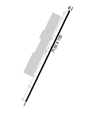
| Lat: N 3331.6 Long: W 11217.7 Elev: 1071 Var: -12 Longest Runway: 7150 | ||
| Dept. ATIS: 119.42 Arr. ATIS: 119.42 AWOS: 119.42 Ground: 118.0 Tower: 121.0 | ||
| ||||||||||||||||||||||||||||||||||||||||||||
| ||||||||||||||||||||||||||||||||||||||||||||
| ||||||||||||||||||||||||||||||||||||||||||||
| Rwy | Rwy | |||||||
| 7150x100 | 6449' | 7150x100 | 6149' | |||||
| Runway ID | Single Wheel | Double Wheel | Double Tandem Wheel | Dual Double Wheel |
| 01/19 | 40,000 | 60,000 | N/A | N/A |
| These numbers are Advisory and are not limits. The Airport Manager should have more accurate Weight Limits | ||||
 Airport Diagram might not be current. | |
| Facility Name: | GLENDALE MUNI |
| City Name: | GLENDALE |
| County: | MARICOPA |
| State abbrev: | AZ |
| State Name: | ARIZONA |
| Ownership: | PUBLICLY OWNED |
| Use: | OPEN TO THE PUBLIC |
| Owner's Name: | CITY OF GLENDALE |
| Address: | 5850 W GLENDALE AVE. |
| GLENDALE, AZ 85301 | |
| Owner's Phone: | (623) 930-2188 |
| Manager's Name: | CARL NEWMAN |
| Address: | 6801 N. GLEN HARBOR BLVD 201 |
| GLENDALE, AZ 85307 | |
| Phone: | 623-930-4744; ADMIN CTC: 623-930-2188 (HRS 0800-1700); ARPT OPS: 602-980-0433 (HRS 0600-2000). |
| FAA Region: | WESTERN-PACIFIC |
| FAA Field Office: | PHX |
| Date | Sunrise | Sunset |
|---|---|---|
| 09/24/21 Friday | 6:19 | 18:23 |
| 09/25/21 Saturday | 6:19 | 18:22 |
| 09/26/21 Sunday | 6:20 | 18:21 |
| 09/27/21 Monday | 6:21 | 18:19 |
| 09/28/21 Tuesday | 6:21 | 18:18 |
| 09/29/21 Wednesday | 6:22 | 18:16 |
| 09/30/21 Thursday | 6:23 | 18:15 |
| 10/01/21 Friday | 6:23 | 18:14 |
| 10/02/21 Saturday | 6:24 | 18:12 |
| 10/03/21 Sunday | 6:25 | 18:11 |
| 10/04/21 Monday | 6:26 | 18:10 |
| 10/05/21 Tuesday | 6:26 | 18:08 |
| 10/06/21 Wednesday | 6:27 | 18:07 |
| 10/07/21 Thursday | 6:28 | 18:06 |
| Airport Attendance Schedule | 7 Days A Week 0630-1930 |
| Airport Status | OPERATIONAL (This Status can change at any time - please check NOTAMS) |
| Airport Lighting Schedule | WHEN ATCT CLSD ACTVT REIL RWY 01 & 19; PAPI RWY 01 & 19; MIRL RWY 01/19 - CTAF. |
| Airport Storage Available | Tie Downs |
| Extra Services Available | Avionics, Charter, Flight Instruction, Aircraft Rental |
| Wind Indicator | YES - (lighted) |
| Control Tower | YES |
| CTAF Frequency | 121.000 |
| Unicom Frequency | 122.950 |
| Rotating Beacon Color | CLEAR-GREEN (Light Land Airport) |
| Segmented Circle | YES |
| Landing Fee |
| Airport Inspected | STATE - performed by PRIVATE CONTRACT PERSONNEL |
| Inspection Date | 04/12/2021 |
| Type of Fuel Available | Grade 100LL, JET A-1 (icing inhibitor, freeze point -50C); -10FUEL AVAILABLE 24 HRS. SELF-SERV. 100 LL., JET A 0630-1930, FEE OTHER HOURS CALL 623-877-3333 |
| Airframe Repair Service | MAJOR |
| Power Plant Repair Service | MAJOR |
| Latitude | N3331.6 |
| Longitude | W11217.7 (ESTIMATED) |
| Arpt Elevation | 1071ft (SURVEYED) |
| Magnetic Variation | 12E |
| 6 miles W | of GLENDALE |
| Traffic Pattern Altitude | 1030; TPA HIGH PERFORMANCE 1530 FT AGL, HELICOPTER/ULTRALIGHTS 630 FT AGL. |
| Sectional Chart | PHOENIX |
| Operations (Reported) | Yearly | Avg. Daily |
|---|---|---|
| General Aviation Transient | 29629 | 81 |
| General Aviation Local | 56419 | 155 |
| Air Taxi | 280 | 1 |
| Commerical | 0 | 0 |
| Commuter | 0 | 0 |
| Military | 4 | 0 |
| Aircraft based on Field | |
|---|---|
| General Aviation Singles | 82 |
| General Aviation Multi | 8 |
| Jet Aircraft | 0 |
| General Aviation Helicopters | 2 |
| Military Aircraft | 0 |
| Gliders | 1 |
| Ultralights | 1 |
| FSS on field | NO |
| FSS tie-in | PRESCOTT |
| FSS Phone | 1-800-WX-BRIEF |
| Who issues Notams | GEU |
| Notam D service at airport | YES |
| ARTCC Name | ALBUQUERQUE |
| Airport Certification | |
| Aircraft Rescue & Firefighting Index | None |
| Airport of Entry | No |
| Custom Landing Rights | No |
| Joint Civil/Military | No |
| Military Landing rights | No |
| NATIONAL PLAN OF INTEGRATED AIRPORT SYSTEMS (NPIAS) |
| GRANT AGREEMENTS UNDER FAAP/ADAP/AIP |
| ASSURANCES PURSUANT TO TITLE VI, CIVIL RIGHTS ACT OF 1964 |
| THIS AIRPORT HAS BEEN SURVEYED BY THE NATIONAL GEODETIC SURVEY. |
| BE ALERT TO HVY MILITARY JET TFC 5 MILES WEST. |
| HIGH TENSION POWER LINES 1/4 MILE WEST PARALLEL TO RWY UNMARKED AND UNLIGHTED. |
| COYOTES & BIRDS ON AND INVOF ARPT. |
| TGL DISCOURAGED BTN 2200-0600. |
| AVOID NOISE SENSITIVE AREAS N & SE OF ARPT. RWY 01 PREFERRED FOR NOISE ABATEMENT. |
| CTC ARPT MGMT FOR ADDITIONAL NOISE ABATEMENT PROCEDURES. |
| WEST SIDE HELICOPTER PATTERN NOT AVBL SS-SR. |
| FOR CD WHEN ATCT CLSD, CTC PHOENIX APCH AT 602-306-2565. |
Airport Communications & Frequencies:
| |||||||||||||||||||||||||||||||
| Runway: 01 | Runway: 19 | ||
| Mag heading: | 14° | Mag heading: | 194° |
| Rwy Slope: | .42% Up | Rwy Slope: | -.42% Down |
| Approach: | Approach: | ||
| Pattern: | Right Traffic | Pattern: | Left Traffic |
| Markings: | BASIC | Markings: | NONPRECISION INSTRUMENT |
| Marking Condition: | GOOD | Marking Condition: | GOOD |
| Arresting Dev: | Arresting Dev: | ||
| Lat & Long: | N3331.1 W11218.0 | Lat. & Long.: | N3332.1 W11217.4 |
| Elev: | 1041.4 ft. MSL | Elev: | 1071.3 ft. MSL |
| TCH: | 38 ft. AGL | TCH: | 30 ft. AGL |
| Visual Glide Path: | 3.00 degrees | Visual Glide Path: | 3.00 degrees |
| Displaced Threshold: | 701 feet | Displaced Threshold: | 1001 feet |
| Touchdown Zone: | YES | Touchdown Zone: | YES |
| Touchdown Elev.: | 1049.0 feet | Touchdown Elev.: | 1065.4 feet |
| Visual Glide Slope: | 2-Light PAPI on LEFT side of Runway | Visual Glide Slope: | 2-Light PAPI on LEFT side of Runway |
| RVR Equipment: | RVR Equipment: | ||
| RVV Equipment: | NO | RVV Equipment: | NO |
| Approach Lights: | Approach Lights: | ||
| REIL: | YES | REIL: | YES |
| Centerline Lights: | NO | Centerline Lights: | NO |
| Touchdown lights: | NO | Touchdown lights: | NO |
| Runway Category: | Runway with a Non-precision Approach having visibility minimums greater than 3/4 mile | Runway Category: | Runway with a Non-precision Approach having visibility minimums greater than 3/4 mile |
| Declared Distances: | TORA:7150' TODA:7150' ASDA:6980' LDA:6279' | Declared Distances: | TORA:7150' TODA:7150' ASDA:7116' LDA:6115' |
| Obstructions: | ROAD | Obstructions: | FENCE |
| Marked: | NOT Marked/Lighted | Marked: | NOT Marked/Lighted |
| Clearance slope: | +13 FT ROAD 135 FT FROM DSPLCD THLD 275 FT RIGHT; APCH SLOPE 10:1 AT DSPLCD THLD. | Clearance slope: | +14 FT ROAD 470 FT FROM DSPLCD THLD 310 FT LEFT; APCH SLOPE 33:1 AT DSPLCD THLD. |
| Obstruction height: | 13 feet AGL | Obstruction height: | 6 feet AGL |
| Dist. from runway: | 201 feet | Dist. from runway: | 201 feet |
| Centerline offset: | 150 right of centerline | Centerline offset: | 150 feet right of centerline |
| Comments: | +13 FT ROAD 0-200 FT FROM END OF RWY 150 FT RIGHT. | Comments: | +12 FT BLAST FENCE 95FT FROM END OF RWY 0 B. |
Thanks for using FltPlan.com
all rights reserved © 1999-2021 by Flight Plan LLC
