
| FORT WORTH MEACHAM INTL FORT WORTH TX |
| |
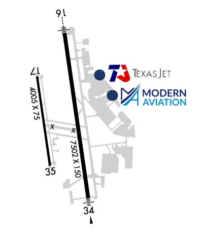
| Lat: N 3249.2 Long: W 09721.7 Elev: 710 Var: -08 Longest Runway: 7502 | ||
| Clr Del: 124.65 Dept. ATIS: 120.7 Arr. ATIS: 120.7 Ground: 121.9 Tower: 118.3 | ||

| |||||||||||||||||||||||||||||||||||||||||||||||||||||||||||||||||||||
| |||||||||||||||||||||||||||||||||||||||||||||||||||||||||||||||||||||
| |||||||||||||||||||||||||||||||||||||||||||||||||||||||||||||||||||||
| |||||||||||||||||||||||||||||||||||||||||||||||||||||||||||||||||||||
| FBOs at nearby airports who want your business: | |||||||||||||||||
| |||||||||||||||||
| Rwy | Rwy | |||||||
| 7502x150 | 7502' | 109.90 - 164° | 7502x150 | 7502' | 109.90 - 344° | |||
| 4005x75 | 4005' | 4005x75 | 4005' | |||||
| Runway ID | Single Wheel | Double Wheel | Double Tandem Wheel | Dual Double Wheel |
| 16/34 | 80,000 | 100,000 | 190,000 | 350,000 |
| 17/35 | 12,500 | 50,000 | N/A | N/A |
| H1 | N/A | N/A | N/A | N/A |
| H2 | N/A | N/A | N/A | N/A |
| These numbers are Advisory and are not limits. The Airport Manager should have more accurate Weight Limits | ||||
 Airport Diagram might not be current. | |
| Facility Name: | FORT WORTH MEACHAM INTL |
| City Name: | FORT WORTH |
| County: | TARRANT |
| State abbrev: | TX |
| State Name: | TEXAS |
| Ownership: | PUBLICLY OWNED |
| Use: | OPEN TO THE PUBLIC |
| Owner's Name: | CITY OF FORT WORTH |
| Address: | 1000 THROCKMORTON ST. |
| FORT WORTH, TX 76102-6311 | |
| Owner's Phone: | 817-392-5400 |
| Manager's Name: | AARON BARTH |
| Address: | 201 AMERICAN CONCOURSE, SUITE 330 |
| FORT WORTH, TX 76106-2749 | |
| Phone: | 817 392-5400 |
| FAA Region: | SOUTHWEST |
| FAA Field Office: | TEX |
| Date | Sunrise | Sunset |
|---|---|---|
| 08/01/25 Friday | 6:43 | 20:28 |
| 08/02/25 Saturday | 6:44 | 20:27 |
| 08/03/25 Sunday | 6:44 | 20:26 |
| 08/04/25 Monday | 6:45 | 20:26 |
| 08/05/25 Tuesday | 6:46 | 20:25 |
| 08/06/25 Wednesday | 6:46 | 20:24 |
| 08/07/25 Thursday | 6:47 | 20:23 |
| 08/08/25 Friday | 6:48 | 20:22 |
| 08/09/25 Saturday | 6:48 | 20:21 |
| 08/10/25 Sunday | 6:49 | 20:20 |
| 08/11/25 Monday | 6:50 | 20:19 |
| 08/12/25 Tuesday | 6:51 | 20:18 |
| 08/13/25 Wednesday | 6:51 | 20:17 |
| 08/14/25 Thursday | 6:52 | 20:16 |
| Airport Attendance Schedule | CONTINUOUS |
| Airport Status | OPERATIONAL (This Status can change at any time - please check NOTAMS) |
| Airport Lighting Schedule | SS-SR |
| Airport Storage Available | Tie Downs, Hanger |
| Extra Services Available | Air Ambulance, Avionics, Charter, Flight Instruction, Aircraft Rental, Aircraft Sales, Annual Surveying |
| Wind Indicator | YES - (lighted) |
| Control Tower | YES |
| CTAF Frequency | |
| Unicom Frequency | |
| Rotating Beacon Color | WG |
| Segmented Circle | YES |
| Landing Fee | NO |
| Airport Inspected | FEDERAL - performed by FAA AIRPORTS FIELD PERSONNEL |
| Inspection Date | 01/14/2025 |
| Type of Fuel Available | Grade 100LL, JET A (freeze point -40C), JET A-1 (icing inhibitor, freeze point -50C) |
| Airframe Repair Service | MAJOR |
| Power Plant Repair Service | MAJOR |
| Latitude | N3249.2 |
| Longitude | W09721.7 (ESTIMATED) |
| Arpt Elevation | 710ft (SURVEYED) |
| Magnetic Variation | 08E |
| 5 miles N | of FORT WORTH |
| Traffic Pattern Altitude | TPA - RWY 17/35 R/W 1300(590) AGL, F/W 1500(790) AGL, RWY 16/34 1500(790) AGL, JETS 2000(1290) AGL. |
| Sectional Chart | DALLAS-FT WORTH |
| Operations (Reported) | Yearly | Avg. Daily |
|---|---|---|
| General Aviation Transient | 0 | 0 |
| General Aviation Local | 0 | 0 |
| Air Taxi | 0 | 0 |
| Commerical | 0 | 0 |
| Commuter | 0 | 0 |
| Military | 0 | 0 |
| Aircraft based on Field | |
|---|---|
| General Aviation Singles | 0 |
| General Aviation Multi | 0 |
| Jet Aircraft | 0 |
| General Aviation Helicopters | 0 |
| Military Aircraft | 0 |
| Gliders | 0 |
| Ultralights | 0 |
| FSS on field | NO |
| FSS tie-in | FORT WORTH |
| FSS Phone | 1-800-WX-BRIEF |
| Who issues Notams | FTW |
| Notam D service at airport | YES |
| ARTCC Name | FORT WORTH |
| Airport Certification | |
| Aircraft Rescue & Firefighting Index | AIRPORT HAS A CERTIFICATE UNDER CFR PART 139 |
| Airport of Entry | No |
| Custom Landing Rights | No; US CUSTOMS USER FEE ARPT. |
| Joint Civil/Military | No |
| Military Landing rights | YES |
| NATIONAL PLAN OF INTEGRATED AIRPORT SYSTEMS (NPIAS) |
| GRANT AGREEMENTS UNDER FAAP/ADAP/AIP |
| SURPLUS PROPERTY AGREEMENT UNDER PUBLIC LAW 289 |
| ASSURANCES PURSUANT TO TITLE VI, CIVIL RIGHTS ACT OF 1964 |
| AGREEMENT UNDER DLAND OR DCLA HAS EXPIRED. |
| RWY 17/35, TWYS B, B1, C AND D WEST OF RWY 16/34, TWY M EAST OF TWY A, H, J, TXL G SE OF TXL N CLSD TO ACR ACFT WITH MORE THAN 30 PSGR SEATS. |
| RWY 17/35 DESIGNED FOR ACFT WITH WINGSPAN 49 FT OR LESS. TWYS B & B1 DESIGNED FOR ACFT WITH WINGSPAN LESS THAN 79 FT. RWY 16/34 & TWYS A, A1 & M DESIGNED FOR ACFT WITH WINGSPAN LESS THAN 171 FT. ALL OTHER TWYS DESIGNED FOR ACFT WITH WINGSPAN LESS THAN 118 FT. |
| H1 & H2 HELIPADS ARE VMC DALGT USE ONLY; NON-MOVEMENT AREA. |
| MKD US CUST PRKG SOUTHEAST OF TXL G AND TXL N INTXN. |
| HELO SKIDDING OPNS PROHIBITED ON RWY 17/35. IF SKIDDING IS RQRD, COORD WITH ATCT TO USE TWY B. |
| PPR FOR ACR OPNS WITH MORE THAN 30 PSGR SEATS - 24 HR NOTICE RQRD - CALL ARPT OPS 817-994-0653. |
| ARPT FEES FOR USE OF CUST SVCS WILL BE COLLD IMT UPON LDG BY CITY OF FORT WORTH ARPT OPNS PSNL. |
| RWY 17/35 LED LGT CAN APPR BRGTR THAN RWY 16/34; ENSURE COR RWY ALNMT. |
| HELS REPOSITIONING BYD IMT PRKG APRON AND UNDER THEIR OWN PWR MUST CTC ATC. |
| ARFF INDEX B AVBL ALL USERS WITH PPR. |
| BIRDS ON & INVOF ARPT. |
Airport Communications & Frequencies:
| ||||||||||||||||||||||||||||||||
| Runway: 16 | Runway: 34 | ||
| Mag heading: | 164° | Mag heading: | 344° |
| Rwy Slope: | -.48% Down | Rwy Slope: | .48% Up |
| Approach: | ILS/DME | Approach: | ILS/DME |
| Pattern: | Left Traffic | Pattern: | Right Traffic |
| Markings: | PRECISION INSTRUMENT | Markings: | PRECISION INSTRUMENT |
| Marking Condition: | GOOD | Marking Condition: | GOOD |
| Arresting Dev: | Arresting Dev: | ||
| Lat & Long: | N3249.8 W09721.7 | Lat. & Long.: | N3248.6 W09721.5 |
| Elev: | 710.1 ft. MSL | Elev: | 674.0 ft. MSL |
| TCH: | 59 ft. AGL | TCH: | |
| Visual Glide Path: | 3.00 degrees | Visual Glide Path: | |
| Displaced Threshold: | No | Displaced Threshold: | No |
| Touchdown Zone: | YES | Touchdown Zone: | YES |
| Touchdown Elev.: | 710.1 feet | Touchdown Elev.: | 679.8 feet |
| Visual Glide Slope: | 4-Light PAPI on RIGHT side of Runway | Visual Glide Slope: | |
| RVR Equipment: | TOUCHDOWN | RVR Equipment: | ROLLOUT |
| RVV Equipment: | NO | RVV Equipment: | NO |
| Approach Lights: | MALSR - 1,400 foot medium intensity approach lighting system with runway alignment indicator lights | Approach Lights: | MALS - 1,400 foot medium intensity approach lighting system |
| REIL: | NO | REIL: | NO |
| Centerline Lights: | NO | Centerline Lights: | NO |
| Touchdown lights: | NO | Touchdown lights: | NO |
| Runway Category: | Precision Instrument Runway | Runway Category: | Precision Instrument Runway |
| Declared Distances: | TORA:7502' TODA:7502' ASDA:7502' LDA:7502' | Declared Distances: | TORA:7502' TODA:7502' ASDA:7455' LDA:7455' |
| Obstructions: | POLE | Obstructions: | |
| Marked: | NOT Marked/Lighted | Marked: | |
| Clearance slope: | 40:1 | Clearance slope: | 50:1 |
| Obstruction height: | 31 feet AGL | Obstruction height: | |
| Dist. from runway: | 1450 feet | Dist. from runway: | |
| Centerline offset: | 625 left of centerline | Centerline offset: | |
| Comments: | Comments: |
| Runway: 17 | Runway: 35 | ||
| Mag heading: | 164° | Mag heading: | 344° |
| Rwy Slope: | -.02% Down | Rwy Slope: | .02% Up |
| Approach: | Approach: | ||
| Pattern: | Right Traffic | Pattern: | Left Traffic |
| Markings: | NONPRECISION INSTRUMENT | Markings: | NONPRECISION INSTRUMENT |
| Marking Condition: | GOOD | Marking Condition: | GOOD |
| Arresting Dev: | Arresting Dev: | ||
| Lat & Long: | N3249.5 W09722.0 | Lat. & Long.: | N3248.8 W09721.9 |
| Elev: | 668.2 ft. MSL | Elev: | 667.2 ft. MSL |
| TCH: | 56 ft. AGL | TCH: | 43 ft. AGL |
| Visual Glide Path: | 3.75 degrees | Visual Glide Path: | 3.25 degrees |
| Displaced Threshold: | No | Displaced Threshold: | No |
| Touchdown Zone: | YES | Touchdown Zone: | YES |
| Touchdown Elev.: | 672.1 feet | Touchdown Elev.: | 672.1 feet |
| Visual Glide Slope: | 2-Light PAPI on LEFT side of Runway | Visual Glide Slope: | 2-Light PAPI on LEFT side of Runway |
| RVR Equipment: | RVR Equipment: | ||
| RVV Equipment: | NO | RVV Equipment: | NO |
| Approach Lights: | Approach Lights: | ||
| REIL: | NO | REIL: | NO |
| Centerline Lights: | NO | Centerline Lights: | NO |
| Touchdown lights: | NO | Touchdown lights: | NO |
| Runway Category: | Runway with a Visual Approach | Runway Category: | Runway with a Visual Approach |
| Declared Distances: | Declared Distances: | ||
| Obstructions: | BERM | Obstructions: | |
| Marked: | LIGHTED | Marked: | |
| Clearance slope: | 29:1 | Clearance slope: | 50:1 |
| Obstruction height: | 39 feet AGL | Obstruction height: | |
| Dist. from runway: | 1361 feet | Dist. from runway: | |
| Centerline offset: | 1 right of centerline | Centerline offset: | |
| Comments: | Comments: |
Thanks for using FltPlan.com
all rights reserved © 1999-2025 by Flight Plan LLC


