
| BISHOP INTL FLINT MI |
| |
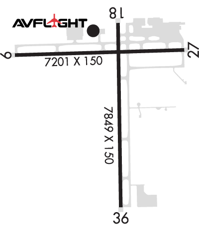
| Lat: N 4257.9 Long: W 08344.7 Elev: 782 Var: +06 Longest Runway: 7849 | ||
| Clr Del: 121.75 Dept. ATIS: 133.15 Arr. ATIS: 133.15 Ground: 121.9 Tower: 126.3 | ||
| |||||||||||||||||||||||||||||||
| |||||||||||||||||||||||||||||||
| |||||||||||||||||||||||||||||||
| Rwy | Rwy | |||||||
| 7201x150 | 7201' | 109.90 - 094° | 7201x150 | 7201' | 109.90 - 274° | |||
| 7849x150 | 7649' | 7849x150 | 7849' | |||||
| Runway ID | Single Wheel | Double Wheel | Double Tandem Wheel | Dual Double Wheel |
| 09/27 | 120,000 | 250,000 | 550,000 | N/A |
| 18/36 | 120,000 | 250,000 | 550,000 | N/A |
| These numbers are Advisory and are not limits. The Airport Manager should have more accurate Weight Limits | ||||
 Airport Diagram might not be current. | |
| Facility Name: | BISHOP INTL |
| City Name: | FLINT |
| County: | GENESEE |
| State abbrev: | MI |
| State Name: | MICHIGAN |
| Ownership: | PUBLICLY OWNED |
| Use: | OPEN TO THE PUBLIC |
| Owner's Name: | BISHOP INTL ARPT AUTH |
| Address: | G-3425 W BRISTOL RD |
| FLINT, MI 48507 | |
| Owner's Phone: | 810-235-6560 |
| Manager's Name: | NINO SAPONE |
| Address: | G-3425 W BRISTOL RD |
| FLINT, MI 48507 | |
| Phone: | 810-235-6560 |
| FAA Region: | GREAT LAKES |
| FAA Field Office: | DET |
| Date | Sunrise | Sunset |
|---|---|---|
| 09/24/21 Friday | 7:24 | 19:29 |
| 09/25/21 Saturday | 7:25 | 19:27 |
| 09/26/21 Sunday | 7:26 | 19:26 |
| 09/27/21 Monday | 7:27 | 19:24 |
| 09/28/21 Tuesday | 7:29 | 19:22 |
| 09/29/21 Wednesday | 7:30 | 19:20 |
| 09/30/21 Thursday | 7:31 | 19:18 |
| 10/01/21 Friday | 7:32 | 19:17 |
| 10/02/21 Saturday | 7:33 | 19:15 |
| 10/03/21 Sunday | 7:34 | 19:13 |
| 10/04/21 Monday | 7:35 | 19:11 |
| 10/05/21 Tuesday | 7:37 | 19:10 |
| 10/06/21 Wednesday | 7:38 | 19:08 |
| 10/07/21 Thursday | 7:39 | 19:06 |
| Airport Attendance Schedule | CONTINUOUS |
| Airport Status | OPERATIONAL (This Status can change at any time - please check NOTAMS) |
| Airport Lighting Schedule | WHEN ATCT CLSD ACTVT MALSR RWY 09 & 27 - CTAF. REIL RWY 18 & 36; HIRL RWY 09/27 & 18/36 OPR CONSLY AT PRESET INTST. |
| Airport Storage Available | Tie Downs, Hanger |
| Extra Services Available | Air Freight, Cargo Handling, Charter, Flight Instruction, Aircraft Sales |
| Wind Indicator | YES - (lighted) |
| Control Tower | YES |
| CTAF Frequency | 126.300 |
| Unicom Frequency | 122.950 |
| Rotating Beacon Color | CLEAR-GREEN (Light Land Airport) |
| Segmented Circle | YES |
| Landing Fee |
| Airport Inspected | FEDERAL - performed by FAA AIRPORTS FIELD PERSONNEL |
| Inspection Date | 05/21/2019 |
| Type of Fuel Available | Grade 100LL, JET A (freeze point -40C) |
| Airframe Repair Service | MAJOR |
| Power Plant Repair Service | MAJOR |
| Latitude | N4257.9 |
| Longitude | W08344.7 (ESTIMATED) |
| Arpt Elevation | 782ft (SURVEYED) |
| Magnetic Variation | 06W |
| 3 miles SW | of FLINT |
| Traffic Pattern Altitude | |
| Sectional Chart | DETROIT |
| Operations (Reported) | Yearly | Avg. Daily |
|---|---|---|
| General Aviation Transient | 15104 | 41 |
| General Aviation Local | 3675 | 10 |
| Air Taxi | 6028 | 17 |
| Commerical | 5196 | 14 |
| Commuter | 0 | 0 |
| Military | 198 | 1 |
| Aircraft based on Field | |
|---|---|
| General Aviation Singles | 70 |
| General Aviation Multi | 21 |
| Jet Aircraft | 2 |
| General Aviation Helicopters | 0 |
| Military Aircraft | 0 |
| Gliders | 0 |
| Ultralights | 0 |
| FSS on field | NO |
| FSS tie-in | LANSING |
| FSS Phone | 1-800-WX-BRIEF |
| Who issues Notams | FNT |
| Notam D service at airport | YES |
| ARTCC Name | CLEVELAND |
| Airport Certification | AIRPORT RECEIVING SCHEDULED AIR CARRIER SERVICE FROM CARRIERS CERTIFICATED BY THE CIVIL AERONAUTICS BOARD |
| Aircraft Rescue & Firefighting Index | AIRPORT HAS A CERTIFICATE UNDER CFR PART 139 |
| Airport of Entry | YES |
| Custom Landing Rights | No |
| Joint Civil/Military | No |
| Military Landing rights | YES |
| NATIONAL PLAN OF INTEGRATED AIRPORT SYSTEMS (NPIAS) |
| GRANT AGREEMENTS UNDER FAAP/ADAP/AIP |
| ASSURANCES PURSUANT TO TITLE VI, CIVIL RIGHTS ACT OF 1964 |
| AGREEMENT UNDER DLAND OR DCLA HAS EXPIRED. |
| BIRDS & DEER ON & INVOF ARPT. |
| FOR CD WHEN ATCT CLSD CTC GREAT LAKES APCH AT 269-459-3345, WHEN APCH CLSD CTC CLEVELAND ARTCC AT 440-774-0224/0490. |
Airport Communications & Frequencies:
| |||||||||||||||||||||||||||||||||||||
| Runway: 09 | Runway: 27 | ||
| Mag heading: | 94° | Mag heading: | 274° |
| Rwy Slope: | -.02% Down | Rwy Slope: | .02% Up |
| Approach: | ILS | Approach: | ILS |
| Pattern: | Left Traffic | Pattern: | Left Traffic |
| Markings: | PRECISION INSTRUMENT | Markings: | PRECISION INSTRUMENT |
| Marking Condition: | FAIR | Marking Condition: | FAIR |
| Arresting Dev: | Arresting Dev: | ||
| Lat & Long: | N4258.1 W08345.6 | Lat. & Long.: | N4258.2 W08344.0 |
| Elev: | 764.0 ft. MSL | Elev: | 762.7 ft. MSL |
| TCH: | 63 ft. AGL | TCH: | 56 ft. AGL |
| Visual Glide Path: | 3.00 degrees | Visual Glide Path: | 3.00 degrees |
| Displaced Threshold: | No | Displaced Threshold: | No |
| Touchdown Zone: | YES | Touchdown Zone: | YES |
| Touchdown Elev.: | 771.3 feet | Touchdown Elev.: | 770.3 feet |
| Visual Glide Slope: | 4-Light PAPI on RIGHT side of Runway | Visual Glide Slope: | 4-Light PAPI on LEFT side of Runway |
| RVR Equipment: | TOUCHDOWN | RVR Equipment: | ROLLOUT |
| RVV Equipment: | NO | RVV Equipment: | NO |
| Approach Lights: | MALSR - 1,400 foot medium intensity approach lighting system with runway alignment indicator lights | Approach Lights: | MALSR - 1,400 foot medium intensity approach lighting system with runway alignment indicator lights |
| REIL: | NO | REIL: | NO |
| Centerline Lights: | NO | Centerline Lights: | NO |
| Touchdown lights: | NO | Touchdown lights: | NO |
| Runway Category: | Precision Instrument Runway | Runway Category: | Precision Instrument Runway |
| Declared Distances: | TORA:7201' TODA:7201' ASDA:7201' LDA:7201' | Declared Distances: | TORA:7201' TODA:7201' ASDA:7201' LDA:7201' |
| Obstructions: | TREES | Obstructions: | TREES |
| Marked: | NOT Marked/Lighted | Marked: | NOT Marked/Lighted |
| Clearance slope: | 37:1 | Clearance slope: | 36:1 |
| Obstruction height: | 60 feet AGL | Obstruction height: | 76 feet AGL |
| Dist. from runway: | 2460 feet | Dist. from runway: | 2968 feet |
| Centerline offset: | 540 left of centerline | Centerline offset: | 98 feet right of centerline |
| Comments: | Comments: |
| Runway: 18 | Runway: 36 | ||
| Mag heading: | 185° | Mag heading: | 5° |
| Rwy Slope: | .19% Up | Rwy Slope: | -.19% Down |
| Approach: | Approach: | ||
| Pattern: | Left Traffic | Pattern: | Left Traffic |
| Markings: | NONPRECISION INSTRUMENT | Markings: | NONPRECISION INSTRUMENT |
| Marking Condition: | FAIR | Marking Condition: | FAIR |
| Arresting Dev: | Arresting Dev: | ||
| Lat & Long: | N4258.4 W08344.6 | Lat. & Long.: | N4257.1 W08344.6 |
| Elev: | 764.0 ft. MSL | Elev: | 779.2 ft. MSL |
| TCH: | 47 ft. AGL | TCH: | 55 ft. AGL |
| Visual Glide Path: | 3.00 degrees | Visual Glide Path: | 3.00 degrees |
| Displaced Threshold: | 200 feet | Displaced Threshold: | No |
| Touchdown Zone: | YES | Touchdown Zone: | YES |
| Touchdown Elev.: | 777.1 feet | Touchdown Elev.: | 782.3 feet |
| Visual Glide Slope: | 4-Light PAPI on RIGHT side of Runway; UNUSBL BYD 8 DEGS LEFT OF CNTRLN. | Visual Glide Slope: | 4-Light PAPI on LEFT side of Runway |
| RVR Equipment: | RVR Equipment: | ||
| RVV Equipment: | NO | RVV Equipment: | NO |
| Approach Lights: | Approach Lights: | ||
| REIL: | YES | REIL: | YES |
| Centerline Lights: | NO | Centerline Lights: | NO |
| Touchdown lights: | NO | Touchdown lights: | NO |
| Runway Category: | Runway with a Non-precision Approach having visibility minimums greater than 3/4 mile | Runway Category: | Runway with a Non-precision Approach having visibility minimums greater than 3/4 mile |
| Declared Distances: | TORA:7848' TODA:7848' ASDA:7848' LDA:7648' | Declared Distances: | TORA:7848' TODA:7848' ASDA:7648' LDA:7648' |
| Obstructions: | TREE | Obstructions: | TREE |
| Marked: | NOT Marked/Lighted | Marked: | NOT Marked/Lighted |
| Clearance slope: | 25:1; APCH RATIO 28:1 TO DTHR. | Clearance slope: | 25:1 |
| Obstruction height: | 79 feet AGL | Obstruction height: | 69 feet AGL |
| Dist. from runway: | 2229 feet | Dist. from runway: | 1945 feet |
| Centerline offset: | 299 left of centerline | Centerline offset: | 485 feet left of centerline |
| Comments: | Comments: |
Thanks for using FltPlan.com
all rights reserved © 1999-2021 by Flight Plan LLC


