| FORT COLLINS-LOVELAND MUNI FORT COLLINS/LOVELAN CO |
| |
| Lat: N 4027.1 Long: W 10500.7 Elev: 5016 Var: -09 Longest Runway: 8500 | ||
| Clr Del: 120.25 Dept. ATIS: 135.07 Arr. ATIS: 135.07 AWOS: 135.07 Ground: 121.65 CTAF: 118.4 | ||
| |||||||||||||||||||||||||||||||||||||||||||||||||||||||||||||||||||||
| |||||||||||||||||||||||||||||||||||||||||||||||||||||||||||||||||||||
| |||||||||||||||||||||||||||||||||||||||||||||||||||||||||||||||||||||
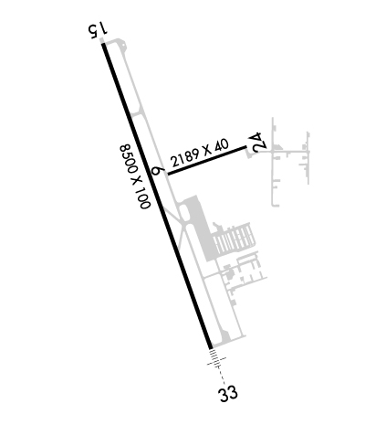
| Rwy | Rwy | |||||||
| 2273x40 | 2273' | 2273x40 | 2273' | |||||
| 8500x100 | 8500' | 8500x100 | 8500' | 109.50 - 331° | ||||
| Runway ID | Single Wheel | Double Wheel | Double Tandem Wheel | Dual Double Wheel |
| 06/24 | N/A | N/A | N/A | N/A |
| 15/33 | 50,000 | 65,000 | 130,000 | N/A |
| These numbers are Advisory and are not limits. The Airport Manager should have more accurate Weight Limits | ||||
 Airport Diagram might not be current. | |
| Facility Name: | NORTHERN COLORADO RGNL |
| City Name: | FORT COLLINS/LOVELAND |
| County: | LARIMER |
| State abbrev: | CO |
| State Name: | COLORADO |
| Ownership: | PUBLICLY OWNED |
| Use: | OPEN TO THE PUBLIC |
| Owner's Name: | FORT COLLINS & LOVELAND |
| Address: | 4900 EARHART ROAD |
| LOVELAND, CO 80538 | |
| Owner's Phone: | 970-962-2850 |
| Manager's Name: | JASON LICON |
| Address: | 4900 EARHART ROAD |
| LOVELAND, CO 80538 | |
| Phone: | 970-962-2852 |
| FAA Region: | NORTHWEST MOUNTAIN |
| FAA Field Office: | DEN |
| Date | Sunrise | Sunset |
|---|---|---|
| 09/24/21 Friday | 6:49 | 18:54 |
| 09/25/21 Saturday | 6:50 | 18:52 |
| 09/26/21 Sunday | 6:51 | 18:51 |
| 09/27/21 Monday | 6:52 | 18:49 |
| 09/28/21 Tuesday | 6:53 | 18:47 |
| 09/29/21 Wednesday | 6:54 | 18:46 |
| 09/30/21 Thursday | 6:55 | 18:44 |
| 10/01/21 Friday | 6:56 | 18:42 |
| 10/02/21 Saturday | 6:57 | 18:41 |
| 10/03/21 Sunday | 6:58 | 18:39 |
| 10/04/21 Monday | 6:59 | 18:38 |
| 10/05/21 Tuesday | 7:00 | 18:36 |
| 10/06/21 Wednesday | 7:01 | 18:34 |
| 10/07/21 Thursday | 7:02 | 18:33 |
| Airport Attendance Schedule | CONTINUOUS |
| Airport Status | OPERATIONAL (This Status can change at any time - please check NOTAMS) |
| Airport Lighting Schedule | DUSK-DAWN - ACTVT & INCR INTST MALSR RWY 33; REIL RWY 15; PAPI RWY 33; HIRL RWY 15/33; TWY LGTS - CTAF. PAPI RWY 15 ON CONSLY. |
| Airport Storage Available | Tie Downs, Hanger |
| Extra Services Available | Charter, Flight Instruction, Aircraft Rental, Aircraft Sales, Annual Surveying |
| Wind Indicator | YES - (lighted) |
| Control Tower | YES |
| CTAF Frequency | 118.400 |
| Unicom Frequency | |
| Rotating Beacon Color | CLEAR-GREEN (Light Land Airport) |
| Segmented Circle | YES |
| Landing Fee | NO |
| Airport Inspected | STATE - performed by FAA AIRPORTS FIELD PERSONNEL |
| Inspection Date | 04/20/2021 |
| Type of Fuel Available | Grade 100LL, JET A (freeze point -40C); -A AVBL 24 HRS WITH CREDIT CARD.; -10AVBL 24 HRS WITH CREDIT CARD. |
| Airframe Repair Service | MAJOR |
| Power Plant Repair Service | MAJOR |
| Latitude | N4027.1 |
| Longitude | W10500.7 (ESTIMATED) |
| Arpt Elevation | 5015ft (SURVEYED) |
| Magnetic Variation | 09E |
| 9 miles SE | of FORT COLLINS/LOVELAND |
| Traffic Pattern Altitude | |
| Sectional Chart | CHEYENNE |
| Operations (Reported) | Yearly | Avg. Daily |
|---|---|---|
| General Aviation Transient | 56000 | 153 |
| General Aviation Local | 35150 | 96 |
| Air Taxi | 3500 | 10 |
| Commerical | 46 | 0 |
| Commuter | 0 | 0 |
| Military | 200 | 1 |
| Aircraft based on Field | |
|---|---|
| General Aviation Singles | 213 |
| General Aviation Multi | 14 |
| Jet Aircraft | 10 |
| General Aviation Helicopters | 17 |
| Military Aircraft | 0 |
| Gliders | 1 |
| Ultralights | 0 |
| FSS on field | NO |
| FSS tie-in | DENVER |
| FSS Phone | 1-800-WX-BRIEF |
| Who issues Notams | FNL |
| Notam D service at airport | YES |
| ARTCC Name | DENVER |
| Airport Certification | AIRPORT RECEIVING SCHEDULED AIR CARRIER SERVICE FROM CARRIERS CERTIFICATED BY THE CIVIL AERONAUTICS BOARD; 24 HR PPR FOR UNSKED ACFT OPS WITH MORE THAN 30 PSGR SEATS, CALL AMGR 970-962-2852. |
| Aircraft Rescue & Firefighting Index | AIRPORT HAS A CERTIFICATE UNDER CFR PART 139 |
| Airport of Entry | No |
| Custom Landing Rights | No |
| Joint Civil/Military | No |
| Military Landing rights | YES |
| NATIONAL PLAN OF INTEGRATED AIRPORT SYSTEMS (NPIAS) |
| GRANT AGREEMENTS UNDER FAAP/ADAP/AIP |
| ASSURANCES PURSUANT TO TITLE VI, CIVIL RIGHTS ACT OF 1964 |
| THIS AIRPORT HAS BEEN SURVEYED BY THE NATIONAL GEODETIC SURVEY. |
| RWY 33 PREFERRED DEP AND ARR RWY WHEN WINDS 5 KTS OR LESS FM ANY DRCTN. |
| RSCD UNMON 0500-1300Z++ |
| RWY 6/24: EDGE REFLECTORS FULL LEN. |
| FOR CD CTC DENVER APCH AT 303-342-1916. |
| 24/7 FUEL & SVC CTC 130.575 OR 970-667-2574. |
| RWY 06/2 4 RWY 24: 2 FT - 4 FT DITCH WI 55 FT L & R OF CNTRLN FULL LEN OF RWY, CONC HEADWALL 43 FT L & R OF CNTRLN, 815 FT FM RWY 06 THR. |
Airport Communications & Frequencies:
| |||||||||||||||||||||||
| Runway: 06 | Runway: 24 | ||
| Mag heading: | 62° | Mag heading: | 242° |
| Rwy Slope: | -.12% Down | Rwy Slope: | .12% Up |
| Approach: | Approach: | ||
| Pattern: | Left Traffic | Pattern: | Left Traffic |
| Markings: | BASIC | Markings: | BASIC |
| Marking Condition: | GOOD | Marking Condition: | GOOD |
| Arresting Dev: | Arresting Dev: | ||
| Lat & Long: | N4027.2 W10500.7 | Lat. & Long.: | N4027.3 W10500.2 |
| Elev: | 4989.8 ft. MSL | Elev: | 4987.1 ft. MSL |
| TCH: | TCH: | ||
| Visual Glide Path: | Visual Glide Path: | ||
| Displaced Threshold: | No | Displaced Threshold: | No |
| Touchdown Zone: | YES | Touchdown Zone: | YES |
| Touchdown Elev.: | 4989.8 feet | Touchdown Elev.: | 4989.8 feet |
| Visual Glide Slope: | Visual Glide Slope: | ||
| RVR Equipment: | RVR Equipment: | ||
| RVV Equipment: | NO | RVV Equipment: | NO |
| Approach Lights: | Approach Lights: | ||
| REIL: | NO | REIL: | NO |
| Centerline Lights: | NO | Centerline Lights: | NO |
| Touchdown lights: | NO | Touchdown lights: | NO |
| Runway Category: | Runway with a Visual Approach | Runway Category: | Runway with a Visual Approach |
| Declared Distances: | TORA:2273' TODA:2273' ASDA:2273' LDA:2273' | Declared Distances: | TORA:2273' TODA:2273' ASDA:2273' LDA:2273' |
| Comments: | Comments: | RWY 24: 2 FT- 4 FT DITCH WI 55 FT L & R OF CNTRLN FULL LEN OF RWY, CONC HEADWALL 43 FT L & R OF CNTRLN 815 FT FM RWY 06 THLD. |
| Runway: 15 | Runway: 33 | ||
| Mag heading: | 151° | Mag heading: | 331° |
| Rwy Slope: | .50% Up | Rwy Slope: | -.50% Down |
| Approach: | Approach: | ILS | |
| Pattern: | Left Traffic | Pattern: | Left Traffic |
| Markings: | PRECISION INSTRUMENT | Markings: | PRECISION INSTRUMENT |
| Marking Condition: | GOOD | Marking Condition: | GOOD |
| Arresting Dev: | Arresting Dev: | ||
| Lat & Long: | N4027.7 W10501.0 | Lat. & Long.: | N4026.4 W10500.4 |
| Elev: | 4973.0 ft. MSL | Elev: | 5015.7 ft. MSL |
| TCH: | 54 ft. AGL | TCH: | 52 ft. AGL |
| Visual Glide Path: | 3.00 degrees | Visual Glide Path: | 3.00 degrees |
| Displaced Threshold: | No | Displaced Threshold: | No |
| Touchdown Zone: | YES | Touchdown Zone: | YES |
| Touchdown Elev.: | 4985.2 feet | Touchdown Elev.: | 5015.7 feet |
| Visual Glide Slope: | 4-Light PAPI on LEFT side of Runway | Visual Glide Slope: | 4-Light PAPI on LEFT side of Runway |
| RVR Equipment: | RVR Equipment: | ||
| RVV Equipment: | NO | RVV Equipment: | NO |
| Approach Lights: | Approach Lights: | MALSR - 1,400 foot medium intensity approach lighting system with runway alignment indicator lights | |
| REIL: | YES | REIL: | NO |
| Centerline Lights: | NO | Centerline Lights: | NO |
| Touchdown lights: | NO | Touchdown lights: | NO |
| Runway Category: | Runway with a Non-precision Approach having visibility minimums greater than 3/4 mile | Runway Category: | Precision Instrument Runway |
| Declared Distances: | TORA:8500' TODA:8500' ASDA:8500' LDA:8500' | Declared Distances: | TORA:8500' TODA:8500' ASDA:8500' LDA:8500' |
Thanks for using FltPlan.com
all rights reserved © 1999-2021 by Flight Plan LLC