
| HECTOR INTL FARGO ND |
| |
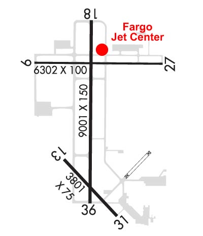
| Lat: N 4655.2 Long: W 09648.9 Elev: 901 Var: -04 Longest Runway: 9001 | ||
| Clr Del: 121.9 Dept. ATIS: 124.5 Arr. ATIS: 124.5 Ground: 121.9 Tower: 133.8 | ||
| |||||||||||||||||||||||||||||||||||||||||||||||||||||||||||||||||||||
| |||||||||||||||||||||||||||||||||||||||||||||||||||||||||||||||||||||
| |||||||||||||||||||||||||||||||||||||||||||||||||||||||||||||||||||||
| |||||||||||||||||||||||||||||||||||||||||||||||||||||||||||||||||||||
| FBOs at nearby airports who want your business: | |||||||||||||||||
| |||||||||||||||||
| Rwy | Rwy | |||||||
| 6302x100 | 6302' | 6302x100 | 6302' | |||||
| 3801x75 | 3801' | 3801x75 | 3801' | |||||
| 9001x150 | 9001' | 108.90 - 176° | 9001x150 | 9001' | 110.30 - 356° | |||
| Runway ID | Single Wheel | Double Wheel | Double Tandem Wheel | Dual Double Wheel |
| 09/27 | 60,000 | 100,000 | N/A | N/A |
| 13/31 | 26,000 | 35,000 | N/A | N/A |
| 18/36 | 100,000 | 200,000 | 400,000 | N/A |
| These numbers are Advisory and are not limits. The Airport Manager should have more accurate Weight Limits | ||||
 Airport Diagram might not be current. | |
| Facility Name: | HECTOR INTL |
| City Name: | FARGO |
| County: | CASS |
| State abbrev: | ND |
| State Name: | NORTH DAKOTA |
| Ownership: | PUBLICLY OWNED |
| Use: | OPEN TO THE PUBLIC |
| Owner's Name: | MUNI ARPT AUTH OF THE CITY OF FARGO |
| Address: | PO BOX 2845 |
| FARGO, ND 58108 | |
| Owner's Phone: | 701-241-1501 |
| Manager's Name: | SHAWN DOBBERSTEIN |
| Address: | PO BOX 2845 |
| FARGO, ND 58108 | |
| Phone: | 701-241-1501 |
| FAA Region: | GREAT LAKES |
| FAA Field Office: | DMA |

| Date | Sunrise | Sunset |
|---|---|---|
| 05/27/26 Wednesday | 5:40 | 21:09 |
| 05/28/26 Thursday | 5:39 | 21:10 |
| 05/29/26 Friday | 5:39 | 21:11 |
| 05/30/26 Saturday | 5:38 | 21:12 |
| 05/31/26 Sunday | 5:37 | 21:13 |
| 06/01/26 Monday | 5:36 | 21:14 |
| 06/02/26 Tuesday | 5:36 | 21:15 |
| 06/03/26 Wednesday | 5:35 | 21:16 |
| 06/04/26 Thursday | 5:35 | 21:17 |
| 06/05/26 Friday | 5:34 | 21:17 |
| 06/06/26 Saturday | 5:34 | 21:18 |
| 06/07/26 Sunday | 5:34 | 21:19 |
| 06/08/26 Monday | 5:33 | 21:20 |
| 06/09/26 Tuesday | 5:33 | 21:20 |
| Airport Attendance Schedule | CONTINUOUS |
| Airport Status | OPERATIONAL (This Status can change at any time - please check NOTAMS) |
| Airport Lighting Schedule | |
| Airport Storage Available | Tie Downs, Hanger |
| Extra Services Available | Air Ambulance, Avionics, Charter, Flight Instruction, Aircraft Rental, Aircraft Sales, Annual Surveying |
| Wind Indicator | YES - (lighted) |
| Control Tower | YES |
| CTAF Frequency | |
| Unicom Frequency | 122.950 |
| Rotating Beacon Color | WG |
| Segmented Circle | NO |
| Landing Fee | NO |
| Airport Inspected | FEDERAL - performed by FAA AIRPORTS FIELD PERSONNEL |
| Inspection Date | 07/30/2025 |
| Type of Fuel Available | Grade 100LL, JET A (freeze point -40C), JET AA++J8 |
| Airframe Repair Service | MAJOR |
| Power Plant Repair Service | MAJOR |
| Latitude | N4655.2 |
| Longitude | W09648.9 (ESTIMATED) |
| Arpt Elevation | 901ft (SURVEYED) |
| Magnetic Variation | 04E |
| 3 miles NW | of FARGO |
| Traffic Pattern Altitude | |
| Sectional Chart | TWIN CITIES |
| Operations (Reported) | Yearly | Avg. Daily |
|---|---|---|
| General Aviation Transient | 0 | 0 |
| General Aviation Local | 0 | 0 |
| Air Taxi | 0 | 0 |
| Commerical | 0 | 0 |
| Commuter | 0 | 0 |
| Military | 0 | 0 |
| Aircraft based on Field | |
|---|---|
| General Aviation Singles | 0 |
| General Aviation Multi | 0 |
| Jet Aircraft | 0 |
| General Aviation Helicopters | 0 |
| Military Aircraft | 0 |
| Gliders | 0 |
| Ultralights | 0 |
| FSS on field | NO |
| FSS tie-in | GRAND FORKS |
| FSS Phone | 1-800-WX-BRIEF |
| Who issues Notams | FAR |
| Notam D service at airport | YES |
| ARTCC Name | MINNEAPOLIS |
| Airport Certification | AIRPORT RECEIVING SCHEDULED AIR CARRIER SERVICE FROM CARRIERS CERTIFICATED BY THE CIVIL AERONAUTICS BOARD; INDEX E ARFF AVBL 2 HOURS PPR CTC 701-476-6790. |
| Aircraft Rescue & Firefighting Index | AIRPORT HAS A CERTIFICATE UNDER CFR PART 139 |
| Airport of Entry | No |
| Custom Landing Rights | YES |
| Joint Civil/Military | No |
| Military Landing rights | YES |
| NATIONAL PLAN OF INTEGRATED AIRPORT SYSTEMS (NPIAS) |
| GRANT AGREEMENTS UNDER FAAP/ADAP/AIP |
| SURPLUS PROPERTY AGREEMENT UNDER PUBLIC LAW 289 |
| ASSURANCES PURSUANT TO TITLE VI, CIVIL RIGHTS ACT OF 1964 |
| AGREEMENT UNDER DLAND OR DCLA HAS EXPIRED. |
| TWY B N OF TWY D RSTRD TO ACFT LESS THAN 130,000 LBS. |
| REMARKS: SEE FLIP AP/1 SUPPLEMENTARY ARPT INFO INCL BASH INFO. |
| CAUTION: USE EXTREME CAUTION FOR UAS OPS IN VCNTY. |
| ANG: BIRD HAZARD (BASH PHASE II) MAR-MAY, AUG-DEC. |
| FLIGHT NOTIFICATION SERVICE (ADCUS) AVAILABLE MON-FRI 0830-1700. |
| MILITARY: ANG: OFFL BUS ONLY CTC BASE OPS DSN 362-8508, C701-451-2508 OPR 1130-2200Z++ CLSD FRI, SAT, SUN & HOL EXC DUR SKED TRNG. OTHER TRAN ACFT CTC JET CNTR C701-235-3600; CSTMS AVBL 24 HR. RCR AVBL FR ANG OPS ON 262.0. RGT TFC RWY 18. |
| BIRDS ON AND INVOF ARPT. |
| RWY 13/3 1 RWY 13/31 NOT AVBL FOR PART 121/PART 380 OPS WITH SKED PAX CARRYING OPS MORE THAN 9 PAX SEATS AND NON-SKED PAX CARRYING OPS MORE THAN 30 PAX SEATS. |
| RWY 18/3 6 AUW-847 |
| RWY 09/2 7 PCR VALUE: 263/R/D/W/U |
| RWY 18/3 6 PCR VALUE: 855/R/D/W/U |
Airport Communications & Frequencies:
| ||||||||||||||||||||||||||||||||||||||||
| Runway: 09 | Runway: 27 | ||
| Mag heading: | 86° | Mag heading: | 266° |
| Rwy Slope: | .04% Up | Rwy Slope: | -.04% Down |
| Approach: | Approach: | ||
| Pattern: | Left Traffic | Pattern: | Left Traffic |
| Markings: | NONPRECISION INSTRUMENT | Markings: | NONPRECISION INSTRUMENT |
| Marking Condition: | GOOD | Marking Condition: | GOOD |
| Arresting Dev: | Arresting Dev: | ||
| Lat & Long: | N4655.6 W09649.6 | Lat. & Long.: | N4655.6 W09648.1 |
| Elev: | 896.2 ft. MSL | Elev: | 898.6 ft. MSL |
| TCH: | 42 ft. AGL | TCH: | 42 ft. AGL |
| Visual Glide Path: | 3.00 degrees | Visual Glide Path: | 3.00 degrees |
| Displaced Threshold: | No | Displaced Threshold: | No |
| Touchdown Zone: | YES | Touchdown Zone: | YES |
| Touchdown Elev.: | 900.0 feet | Touchdown Elev.: | 899.5 feet |
| Visual Glide Slope: | 4-Light PAPI on LEFT side of Runway | Visual Glide Slope: | 4-Light PAPI on LEFT side of Runway |
| RVR Equipment: | RVR Equipment: | ||
| RVV Equipment: | NO | RVV Equipment: | NO |
| Approach Lights: | Approach Lights: | ||
| REIL: | YES | REIL: | YES |
| Centerline Lights: | NO | Centerline Lights: | NO |
| Touchdown lights: | NO | Touchdown lights: | NO |
| Runway Category: | D | Runway Category: | D |
| Declared Distances: | TORA:6302' TODA:6302' ASDA:6302' LDA:6302' | Declared Distances: | TORA:6302' TODA:6302' ASDA:6302' LDA:6302' |
| Obstructions: | Obstructions: | POLE | |
| Marked: | Marked: | LIGHTED | |
| Clearance slope: | 50:1 | Clearance slope: | 35:1 |
| Obstruction height: | Obstruction height: | 25 feet AGL | |
| Dist. from runway: | Dist. from runway: | 1086 feet | |
| Centerline offset: | Centerline offset: | 468 feet left of centerline | |
| Comments: | Comments: |
| Runway: 13 | Runway: 31 | ||
| Mag heading: | 133° | Mag heading: | 313° |
| Rwy Slope: | -.07% Down | Rwy Slope: | .07% Up |
| Approach: | Approach: | ||
| Pattern: | Left Traffic | Pattern: | Left Traffic |
| Markings: | BASIC | Markings: | BASIC |
| Marking Condition: | GOOD | Marking Condition: | GOOD |
| Arresting Dev: | Arresting Dev: | ||
| Lat & Long: | N4654.8 W09649.3 | Lat. & Long.: | N4654.4 W09648.7 |
| Elev: | 901.3 ft. MSL | Elev: | 898.5 ft. MSL |
| TCH: | 61 ft. AGL | TCH: | 37 ft. AGL |
| Visual Glide Path: | 3.00 degrees | Visual Glide Path: | 3.00 degrees |
| Displaced Threshold: | No | Displaced Threshold: | No |
| Touchdown Zone: | YES | Touchdown Zone: | YES |
| Touchdown Elev.: | 901.3 feet | Touchdown Elev.: | 899.5 feet |
| Visual Glide Slope: | 2-Light PAPI on RIGHT side of Runway | Visual Glide Slope: | 2-Light PAPI on LEFT side of Runway |
| RVR Equipment: | RVR Equipment: | ||
| RVV Equipment: | NO | RVV Equipment: | NO |
| Approach Lights: | Approach Lights: | ||
| REIL: | NO | REIL: | NO |
| Centerline Lights: | NO | Centerline Lights: | NO |
| Touchdown lights: | NO | Touchdown lights: | NO |
| Runway Category: | Runway with a Visual Approach | Runway Category: | Runway with a Visual Approach |
| Declared Distances: | TORA:3801' TODA:3801' ASDA:3801' LDA:3801' | Declared Distances: | TORA:3801' TODA:3801' ASDA:3801' LDA:3801' |
| Obstructions: | ROAD | Obstructions: | ROAD |
| Marked: | NOT Marked/Lighted | Marked: | NOT Marked/Lighted |
| Clearance slope: | 47:1 | Clearance slope: | 29:1 |
| Obstruction height: | 7 feet AGL | Obstruction height: | 8 feet AGL |
| Dist. from runway: | 550 feet | Dist. from runway: | 432 feet |
| Centerline offset: | 180 right of centerline | Centerline offset: | 147 feet left of centerline |
| Comments: | Comments: |
| Runway: 18 | Runway: 36 | ||
| Mag heading: | 176° | Mag heading: | 356° |
| Rwy Slope: | -.01% Down | Rwy Slope: | .01% Up |
| Approach: | ILS | Approach: | ILS/DME |
| Pattern: | Left Traffic | Pattern: | Left Traffic |
| Markings: | PRECISION INSTRUMENT | Markings: | PRECISION INSTRUMENT |
| Marking Condition: | GOOD | Marking Condition: | GOOD |
| Arresting Dev: | Arresting Dev: | ||
| Lat & Long: | N4656.0 W09649.0 | Lat. & Long.: | N4654.5 W09649.0 |
| Elev: | 899.8 ft. MSL | Elev: | 899.3 ft. MSL |
| TCH: | 68 ft. AGL | TCH: | 71 ft. AGL |
| Visual Glide Path: | 3.00 degrees | Visual Glide Path: | 3.00 degrees |
| Displaced Threshold: | No | Displaced Threshold: | No |
| Touchdown Zone: | YES | Touchdown Zone: | YES |
| Touchdown Elev.: | 900.0 feet | Touchdown Elev.: | 899.4 feet |
| Visual Glide Slope: | 4-Light PAPI on LEFT side of Runway | Visual Glide Slope: | 4-Light PAPI on RIGHT side of Runway |
| RVR Equipment: | TOUCHDOWN-ROLLOUT | RVR Equipment: | TOUCHDOWN-ROLLOUT |
| RVV Equipment: | NO | RVV Equipment: | YES |
| Approach Lights: | MALSR - 1,400 foot medium intensity approach lighting system with runway alignment indicator lights | Approach Lights: | MALSR - 1,400 foot medium intensity approach lighting system with runway alignment indicator lights |
| REIL: | NO | REIL: | NO |
| Centerline Lights: | NO | Centerline Lights: | NO |
| Touchdown lights: | NO | Touchdown lights: | NO |
| Runway Category: | Precision Instrument Runway | Runway Category: | Precision Instrument Runway |
| Declared Distances: | TORA:9001' TODA:9001' ASDA:9001' LDA:9001' | Declared Distances: | TORA:9001' TODA:9001' ASDA:9001' LDA:9001' |
Thanks for using FltPlan.com
all rights reserved © 1999-2026 by Flight Plan LLC