
| NORTH PALM BEACH COUNTY GENERA WEST PALM BEACH FL |
| |
| Lat: N 2650.8 Long: W 08013.3 Elev: 22 Var: +07 Longest Runway: 4300 | ||
| Clr Del: 120.82 AWOS: 119.97 CTAF: 123.07 | ||

| ||||||||||||||||||||||||||||||||||||||||||||||||||||||||||||||||||||
| ||||||||||||||||||||||||||||||||||||||||||||||||||||||||||||||||||||
| ||||||||||||||||||||||||||||||||||||||||||||||||||||||||||||||||||||
| ||||||||||||||||||||||||||||||||||||||||||||||||||||||||||||||||||||
| ||||||||||||||||||||||||||||||||||||||||||||||||||||||||||||||||||||
| ||||||||||||||||||||||||||||||||||||||||||||||||||||||||||||||||||||
| FBOs at nearby airports who want your business: | |||||||||||||||||
| |||||||||||||||||
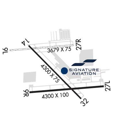
| Rwy | Rwy | |||||||
| 3679x75 | 3679' | 3679x75 | 3679' | |||||
| 4300x100 | 4300' | 110.75 - 092° | 4300x100 | 4300' | ||||
| 4300x75 | 4300' | 4300x75 | 4300' | |||||
| Runway ID | Single Wheel | Double Wheel | Double Tandem Wheel | Dual Double Wheel |
| 09L/27R | N/A | N/A | N/A | N/A |
| 09R/27L | 12,500 | N/A | N/A | N/A |
| 14/32 | 30,000 | N/A | N/A | N/A |
| These numbers are Advisory and are not limits. The Airport Manager should have more accurate Weight Limits | ||||
 Airport Diagram might not be current. | |
| Facility Name: | NORTH PALM BEACH COUNTY GENERAL AVIATION |
| City Name: | WEST PALM BEACH |
| County: | PALM BEACH |
| State abbrev: | FL |
| State Name: | FLORIDA |
| Ownership: | PUBLICLY OWNED |
| Use: | OPEN TO THE PUBLIC |
| Owner's Name: | PALM BEACH COUNTY |
| Address: | DEPARTMENT OF AIRPORTS, 846 PBIA |
| WEST PALM BEACH, FL 33406-1470 | |
| Owner's Phone: | 561-471-7404 |
| Manager's Name: | LAURA BEEBE |
| Address: | 846 PALM BEACH INTL AIRPORT |
| WEST PALM BEACH, FL 33406-1470 | |
| Phone: | 561-471-7420; 561-626-9771 |
| FAA Region: | SOUTHERN |
| FAA Field Office: | ORL |

| Date | Sunrise | Sunset |
|---|---|---|
| 10/26/25 Sunday | 7:27 | 18:43 |
| 10/27/25 Monday | 7:27 | 18:42 |
| 10/28/25 Tuesday | 7:28 | 18:41 |
| 10/29/25 Wednesday | 7:29 | 18:40 |
| 10/30/25 Thursday | 7:29 | 18:40 |
| 10/31/25 Friday | 7:30 | 18:39 |
| 11/01/25 Saturday | 7:31 | 18:38 |
| 11/02/25 Sunday | 6:31 | 17:37 |
| 11/03/25 Monday | 6:32 | 17:37 |
| 11/04/25 Tuesday | 6:33 | 17:36 |
| 11/05/25 Wednesday | 6:33 | 17:36 |
| 11/06/25 Thursday | 6:34 | 17:35 |
| 11/07/25 Friday | 6:35 | 17:34 |
| 11/08/25 Saturday | 6:35 | 17:34 |
| Airport Attendance Schedule | CONTINUOUS |
| Airport Status | OPERATIONAL (This Status can change at any time - please check NOTAMS) |
| Airport Lighting Schedule | DUSK-2100; AFT 2100 ACTVT REIL RWY 09R, 14, 27L, & 32; MIRL RWY 09R/27L & 14/32 - CTAF. |
| Airport Storage Available | Tie Downs, Hanger |
| Extra Services Available | Avionics, Charter, Flight Instruction, Aircraft Rental, Aircraft Sales |
| Wind Indicator | YES - (lighted) |
| Control Tower | NO |
| CTAF Frequency | 123.075 |
| Unicom Frequency | 123.075 |
| Rotating Beacon Color | WG |
| Segmented Circle | Y-L |
| Landing Fee |
| Airport Inspected | STATE - performed by STATE AERONAUTICAL PERSONNEL |
| Inspection Date | 01/08/2025 |
| Type of Fuel Available | Grade 100LL, JET A (freeze point -40C) |
| Airframe Repair Service | MAJOR |
| Power Plant Repair Service | MAJOR |
| Latitude | N2650.8 |
| Longitude | W08013.3 (ESTIMATED) |
| Arpt Elevation | 22ft (SURVEYED) |
| Magnetic Variation | 07W |
| 12 miles NW | of WEST PALM BEACH |
| Traffic Pattern Altitude | |
| Sectional Chart | MIAMI |
| Operations (Reported) | Yearly | Avg. Daily |
|---|---|---|
| General Aviation Transient | 0 | 0 |
| General Aviation Local | 0 | 0 |
| Air Taxi | 0 | 0 |
| Commerical | 0 | 0 |
| Commuter | 0 | 0 |
| Military | 0 | 0 |
| Aircraft based on Field | |
|---|---|
| General Aviation Singles | 0 |
| General Aviation Multi | 0 |
| Jet Aircraft | 0 |
| General Aviation Helicopters | 0 |
| Military Aircraft | 0 |
| Gliders | 0 |
| Ultralights | 0 |
| FSS on field | NO |
| FSS tie-in | MIAMI |
| FSS Phone | 1-800-WX-BRIEF |
| Who issues Notams | MIA |
| Notam D service at airport | YES |
| ARTCC Name | MIAMI |
| Airport Certification | |
| Aircraft Rescue & Firefighting Index | None |
| Airport of Entry | No |
| Custom Landing Rights | No |
| Joint Civil/Military | No |
| Military Landing rights | No |
| NATIONAL PLAN OF INTEGRATED AIRPORT SYSTEMS (NPIAS) |
| NOISE ABATEMENT PROC; RWY 14/32 PREFERRED NGT RWY; H24 NOISE ABATEMENT MNTG - (561) 626-7631. |
| ARPT SFC COND NOT RPRTD FOR ALL RWYS. |
| FOR CD CTC PALM BEACH APCH AT 561-684-9047. |
| FBO SVC FEE MAY APPLY. |
| RWY 9R TDZ MRKGS NOT STD. |
| BIRD ACT INVOF ARPT. |
| EXTSV FLT TRNG MULT RWYS. PRACTICE APCH RWY 9R/27L MNT CTAF & YIELD TO TFC PAT. |
| TWY G1 CLSD. |
| RWY 09R/ 27LACFT OVER 12500 LBS GWT NA. |
| RWY 14/3 2 ACFT OVER 30000 LBS NA. |
Airport Communications & Frequencies:
| ||||||||||||||||
| Runway: 09L | Runway: 27R | ||
| Mag heading: | 92° | Mag heading: | 272° |
| Rwy Slope: | .00% | Rwy Slope: | .00% |
| Approach: | Approach: | ||
| Pattern: | Left Traffic | Pattern: | Right Traffic |
| Markings: | NONSTANDARD | Markings: | NONSTANDARD |
| Marking Condition: | GOOD; PVC PIPE EV 200 FT. | Marking Condition: | GOOD; 09L/27R THLDS MKD WITH PVC PIPES. |
| Arresting Dev: | Arresting Dev: | ||
| Lat & Long: | N2651.0 W08013.8 | Lat. & Long.: | N2651.0 W08013.1 |
| Elev: | 20.8 ft. MSL | Elev: | 20.8 ft. MSL |
| TCH: | TCH: | ||
| Visual Glide Path: | Visual Glide Path: | ||
| Displaced Threshold: | No | Displaced Threshold: | No |
| Touchdown Zone: | YES | Touchdown Zone: | YES |
| Touchdown Elev.: | 22.0 feet | Touchdown Elev.: | 22.0 feet |
| Visual Glide Slope: | Visual Glide Slope: | ||
| RVR Equipment: | RVR Equipment: | ||
| RVV Equipment: | NO | RVV Equipment: | NO |
| Approach Lights: | Approach Lights: | ||
| REIL: | NO | REIL: | NO |
| Centerline Lights: | NO | Centerline Lights: | NO |
| Touchdown lights: | NO | Touchdown lights: | NO |
| Runway Category: | Runway with a Visual Approach | Runway Category: | Runway with a Visual Approach |
| Declared Distances: | Declared Distances: | ||
| Obstructions: | TREE | Obstructions: | TREE |
| Marked: | NOT Marked/Lighted | Marked: | NOT Marked/Lighted |
| Clearance slope: | 25:1 | Clearance slope: | 23:1 |
| Obstruction height: | 67 feet AGL | Obstruction height: | 67 feet AGL |
| Dist. from runway: | 1655 feet | Dist. from runway: | 1560 feet |
| Centerline offset: | 65 right of centerline | Centerline offset: | 45 feet right of centerline |
| Comments: | Comments: |
| Runway: 09R | Runway: 27L | ||
| Mag heading: | 92° | Mag heading: | 272° |
| Rwy Slope: | .00% | Rwy Slope: | .00% |
| Approach: | ILS/DME | Approach: | |
| Pattern: | Right Traffic | Pattern: | Left Traffic |
| Markings: | PRECISION INSTRUMENT | Markings: | NONPRECISION INSTRUMENT |
| Marking Condition: | GOOD | Marking Condition: | GOOD |
| Arresting Dev: | Arresting Dev: | ||
| Lat & Long: | N2650.6 W08013.6 | Lat. & Long.: | N2650.6 W08012.8 |
| Elev: | 21.3 ft. MSL | Elev: | 21.3 ft. MSL |
| TCH: | 40 ft. AGL | TCH: | 40 ft. AGL |
| Visual Glide Path: | 3.00 degrees | Visual Glide Path: | 3.00 degrees |
| Displaced Threshold: | No | Displaced Threshold: | No |
| Touchdown Zone: | YES | Touchdown Zone: | YES |
| Touchdown Elev.: | 21.5 feet | Touchdown Elev.: | 21.5 feet |
| Visual Glide Slope: | 2-Light PAPI on LEFT side of Runway | Visual Glide Slope: | 2-Light PAPI on LEFT side of Runway |
| RVR Equipment: | RVR Equipment: | ||
| RVV Equipment: | NO | RVV Equipment: | NO |
| Approach Lights: | Approach Lights: | ||
| REIL: | YES | REIL: | YES |
| Centerline Lights: | NO | Centerline Lights: | NO |
| Touchdown lights: | NO | Touchdown lights: | NO |
| Runway Category: | Precision Instrument Runway | Runway Category: | Runway with a Non-precision Approach having visibility minimums greater than 3/4 mile |
| Declared Distances: | Declared Distances: | ||
| Obstructions: | Obstructions: | TREE | |
| Marked: | Marked: | NOT Marked/Lighted | |
| Clearance slope: | 50:1 | Clearance slope: | 35:1 |
| Obstruction height: | Obstruction height: | 75 feet AGL | |
| Dist. from runway: | Dist. from runway: | 2820 feet | |
| Centerline offset: | Centerline offset: | 75 feet right of centerline | |
| Comments: | Comments: |
| Runway: 14 | Runway: 32 | ||
| Mag heading: | 142° | Mag heading: | 322° |
| Rwy Slope: | .00% Down | Rwy Slope: | .00% Up |
| Approach: | Approach: | ||
| Pattern: | Right Traffic | Pattern: | Left Traffic |
| Markings: | NONPRECISION INSTRUMENT | Markings: | NONPRECISION INSTRUMENT |
| Marking Condition: | FAIR; THR MKR 4 FT BYD RWY END. | Marking Condition: | FAIR |
| Arresting Dev: | Arresting Dev: | ||
| Lat & Long: | N2651.0 W08013.6 | Lat. & Long.: | N2650.5 W08013.1 |
| Elev: | 21.3 ft. MSL | Elev: | 21.2 ft. MSL |
| TCH: | 40 ft. AGL | TCH: | 40 ft. AGL |
| Visual Glide Path: | 3.00 degrees | Visual Glide Path: | 3.00 degrees |
| Displaced Threshold: | No | Displaced Threshold: | No |
| Touchdown Zone: | YES | Touchdown Zone: | YES |
| Touchdown Elev.: | 21.4 feet | Touchdown Elev.: | 21.4 feet |
| Visual Glide Slope: | 2-Light PAPI on LEFT side of Runway | Visual Glide Slope: | 2-Light PAPI on LEFT side of Runway |
| RVR Equipment: | RVR Equipment: | ||
| RVV Equipment: | NO | RVV Equipment: | NO |
| Approach Lights: | Approach Lights: | ||
| REIL: | YES | REIL: | YES |
| Centerline Lights: | NO | Centerline Lights: | NO |
| Touchdown lights: | NO | Touchdown lights: | NO |
| Runway Category: | Runway with a Non-precision Approach having visibility minimums greater than 3/4 mile | Runway Category: | Runway with a Visual Approach |
| Declared Distances: | Declared Distances: | ||
| Obstructions: | TREES | Obstructions: | TREES |
| Marked: | NOT Marked/Lighted | Marked: | NOT Marked/Lighted |
| Clearance slope: | 37:1 | Clearance slope: | 22:1 |
| Obstruction height: | 51 feet AGL | Obstruction height: | 33 feet AGL |
| Dist. from runway: | 2065 feet | Dist. from runway: | 910 feet |
| Centerline offset: | 115 left of centerline | Centerline offset: | 185 feet left of centerline |
| Comments: | Comments: |
Thanks for using FltPlan.com
all rights reserved © 1999-2025 by Flight Plan LLC