
| ESLER RGNL ALEXANDRIA LA |
| |
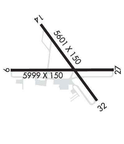
| Lat: N 3123.7 Long: W 09217.7 Elev: 112 Var: -01 Longest Runway: 5998 | ||
| CTAF: 122.8 | ||
| ||||||||||||||||||||||||||||||||||||||||||||
| ||||||||||||||||||||||||||||||||||||||||||||
| ||||||||||||||||||||||||||||||||||||||||||||
| Rwy | Rwy | |||||||
| 5998x150 | 5998' | 5998x150 | 5998' | 111.50 - 270° | ||||
| 5600x150 | 5600' | 5600x150 | 5600' | |||||
| Runway ID | Single Wheel | Double Wheel | Double Tandem Wheel | Dual Double Wheel |
| 09/27 | 75,000 | 150,000 | 220,000 | N/A |
| 14/32 | 75,000 | 150,000 | 220,000 | N/A |
| These numbers are Advisory and are not limits. The Airport Manager should have more accurate Weight Limits | ||||
 Airport Diagram might not be current. | |
| Facility Name: | ESLER RGNL |
| City Name: | ALEXANDRIA |
| County: | RAPIDES |
| State abbrev: | LA |
| State Name: | LOUISIANA |
| Ownership: | PUBLICLY OWNED |
| Use: | OPEN TO THE PUBLIC |
| Owner's Name: | RAPIDES PARISH POLICE JURY |
| Address: | PO BOX 1150 |
| ALEXANDRIA, LA 71309 | |
| Owner's Phone: | 318-767-2536 |
| Manager's Name: | LOUIS BUSBY |
| Address: | 7625 ESLER FIELD RD |
| PINEVILLE, LA 71360 | |
| Phone: | 985-750-0485 |
| FAA Region: | SOUTHWEST |
| FAA Field Office: | LNM |
| Date | Sunrise | Sunset |
|---|---|---|
| 02/05/26 Thursday | 6:59 | 17:48 |
| 02/06/26 Friday | 6:59 | 17:49 |
| 02/07/26 Saturday | 6:58 | 17:49 |
| 02/08/26 Sunday | 6:57 | 17:50 |
| 02/09/26 Monday | 6:56 | 17:51 |
| 02/10/26 Tuesday | 6:55 | 17:52 |
| 02/11/26 Wednesday | 6:55 | 17:53 |
| 02/12/26 Thursday | 6:54 | 17:54 |
| 02/13/26 Friday | 6:53 | 17:55 |
| 02/14/26 Saturday | 6:52 | 17:55 |
| 02/15/26 Sunday | 6:51 | 17:56 |
| 02/16/26 Monday | 6:50 | 17:57 |
| 02/17/26 Tuesday | 6:49 | 17:58 |
| 02/18/26 Wednesday | 6:48 | 17:59 |
| Airport Attendance Schedule | TUE-FRI 0700-1730 |
| Airport Status | OPERATIONAL (This Status can change at any time - please check NOTAMS) |
| Airport Lighting Schedule | ACTVT MALSR RWY 27; REIL RWY 09, 14/32; MIRL RWY 14/32; HIRL RWY 9/27; TWY LGTS TWYS A, B, C, D & E - CTAF. |
| Airport Storage Available | Tie Downs |
| Extra Services Available | NONE |
| Wind Indicator | YES - (lighted) |
| Control Tower | NO |
| CTAF Frequency | 122.800 |
| Unicom Frequency | 122.800 |
| Rotating Beacon Color | WG |
| Segmented Circle | YES |
| Landing Fee | NO |
| Airport Inspected | FEDERAL - performed by STATE AERONAUTICAL PERSONNEL |
| Inspection Date | 01/31/2024 |
| Type of Fuel Available | Grade 100LL, JET A (freeze point -40C); -10FUEL AVBL TUE-FRI 0700-1700; SAT-MON ON CALL IN ADVANCE CALL 318-443-5566. 100LL SELF SERVE 24HRS |
| Airframe Repair Service | None |
| Power Plant Repair Service | None |
| Latitude | N3123.7 |
| Longitude | W09217.7 (ESTIMATED) |
| Arpt Elevation | 111ft (SURVEYED) |
| Magnetic Variation | 01E |
| 10 miles NE | of ALEXANDRIA |
| Traffic Pattern Altitude | |
| Sectional Chart | HOUSTON |
| Operations (Reported) | Yearly | Avg. Daily |
|---|---|---|
| General Aviation Transient | 0 | 0 |
| General Aviation Local | 0 | 0 |
| Air Taxi | 0 | 0 |
| Commerical | 0 | 0 |
| Commuter | 0 | 0 |
| Military | 0 | 0 |
| Aircraft based on Field | |
|---|---|
| General Aviation Singles | 0 |
| General Aviation Multi | 0 |
| Jet Aircraft | 0 |
| General Aviation Helicopters | 0 |
| Military Aircraft | 0 |
| Gliders | 0 |
| Ultralights | 0 |
| FSS on field | NO |
| FSS tie-in | DE RIDDER |
| FSS Phone | 1-800-WX-BRIEF |
| Who issues Notams | ESF |
| Notam D service at airport | YES |
| ARTCC Name | HOUSTON |
| Airport Certification | |
| Aircraft Rescue & Firefighting Index | None |
| Airport of Entry | No |
| Custom Landing Rights | No |
| Joint Civil/Military | No |
| Military Landing rights | YES |
| NATIONAL PLAN OF INTEGRATED AIRPORT SYSTEMS (NPIAS) |
| GRANT AGREEMENTS UNDER FAAP/ADAP/AIP |
| ASSURANCES PURSUANT TO TITLE VI, CIVIL RIGHTS ACT OF 1964 |
| PL 85-204/SPECIAL ACT OF CONGRESS |
| BIRDS ON & INVOF ARPT SEASONALLY. |
| PAEW ADJ RYS & TWYS. |
| FOR CD CTC POLK APCH AT 337-531-2352. |
| CTC APRT MGR FOR DSGND RAMP SPACE FOR PUB USE. |
Airport Communications & Frequencies:
| ||||||||||||||
| Runway: 09 | Runway: 27 | ||
| Mag heading: | 90° | Mag heading: | 270° |
| Rwy Slope: | -.11% Down | Rwy Slope: | .11% Up |
| Approach: | Approach: | ILS/DME | |
| Pattern: | Left Traffic | Pattern: | Left Traffic |
| Markings: | PRECISION INSTRUMENT | Markings: | PRECISION INSTRUMENT |
| Marking Condition: | GOOD | Marking Condition: | GOOD |
| Arresting Dev: | Arresting Dev: | ||
| Lat & Long: | N3123.7 W09218.4 | Lat. & Long.: | N3123.7 W09217.2 |
| Elev: | 96.2 ft. MSL | Elev: | 89.4 ft. MSL |
| TCH: | 51 ft. AGL | TCH: | |
| Visual Glide Path: | 3.00 degrees | Visual Glide Path: | |
| Displaced Threshold: | No | Displaced Threshold: | No |
| Touchdown Zone: | YES | Touchdown Zone: | YES |
| Touchdown Elev.: | 96.6 feet | Touchdown Elev.: | 91.9 feet |
| Visual Glide Slope: | 4-Light PAPI on LEFT side of Runway | Visual Glide Slope: | |
| RVR Equipment: | RVR Equipment: | ||
| RVV Equipment: | NO | RVV Equipment: | NO |
| Approach Lights: | Approach Lights: | MALSR - 1,400 foot medium intensity approach lighting system with runway alignment indicator lights | |
| REIL: | YES; RWY 09 REILS OTS | REIL: | NO |
| Centerline Lights: | NO | Centerline Lights: | NO |
| Touchdown lights: | NO | Touchdown lights: | NO |
| Runway Category: | Runway with a Non-precision Approach having visibility minimums greater than 3/4 mile | Runway Category: | Precision Instrument Runway |
| Declared Distances: | Declared Distances: | ||
| Obstructions: | TREES | Obstructions: | |
| Marked: | NOT Marked/Lighted | Marked: | |
| Clearance slope: | 35:1 | Clearance slope: | 50:1 |
| Obstruction height: | 82 feet AGL | Obstruction height: | |
| Dist. from runway: | 3080 feet | Dist. from runway: | |
| Centerline offset: | B | Centerline offset: | |
| Comments: | Comments: |
| Runway: 14 | Runway: 32 | ||
| Mag heading: | 144° | Mag heading: | 324° |
| Rwy Slope: | -.43% Down | Rwy Slope: | .43% Up |
| Approach: | Approach: | ||
| Pattern: | Left Traffic | Pattern: | Left Traffic |
| Markings: | PRECISION INSTRUMENT | Markings: | PRECISION INSTRUMENT |
| Marking Condition: | POOR; RWY MARKINGS SEVERELY FADED | Marking Condition: | POOR; RWY MARKINGS SEVERELY FADED |
| Arresting Dev: | Arresting Dev: | ||
| Lat & Long: | N3124.1 W09218.0 | Lat. & Long.: | N3123.4 W09217.4 |
| Elev: | 111.6 ft. MSL | Elev: | 87.7 ft. MSL |
| TCH: | 36 ft. AGL | TCH: | 56 ft. AGL |
| Visual Glide Path: | 3.00 degrees | Visual Glide Path: | 3.00 degrees |
| Displaced Threshold: | No | Displaced Threshold: | No |
| Touchdown Zone: | YES | Touchdown Zone: | YES |
| Touchdown Elev.: | 111.8 feet | Touchdown Elev.: | 92.7 feet |
| Visual Glide Slope: | 4-Light PAPI on LEFT side of Runway; RWY 14 PAPI OTS | Visual Glide Slope: | 4-Light PAPI on LEFT side of Runway |
| RVR Equipment: | RVR Equipment: | ||
| RVV Equipment: | NO | RVV Equipment: | NO |
| Approach Lights: | Approach Lights: | ||
| REIL: | YES; RWY 14 REIL OTS | REIL: | YES |
| Centerline Lights: | NO | Centerline Lights: | NO |
| Touchdown lights: | NO | Touchdown lights: | NO |
| Runway Category: | Runway with a Visual Approach | Runway Category: | Runway with a Visual Approach |
| Declared Distances: | Declared Distances: | ||
| Obstructions: | TREES | Obstructions: | FENCE |
| Marked: | NOT Marked/Lighted | Marked: | NOT Marked/Lighted |
| Clearance slope: | 16:1 | Clearance slope: | |
| Obstruction height: | 116 feet AGL | Obstruction height: | 5 feet AGL |
| Dist. from runway: | 2056 feet | Dist. from runway: | 185 feet |
| Centerline offset: | 1324B | Centerline offset: | |
| Comments: | Comments: | FENCE 100 FT 0B AND SMALL TREE 14 FT TALL 232 FT FM END OF RY. |
Thanks for using FltPlan.com
all rights reserved © 1999-2026 by Flight Plan LLC
