
| CAPTAIN JACK THOMAS/EL DORADO EL DORADO KS |
| |
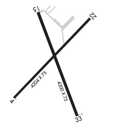
| Lat: N 3746.4 Long: W 09649.1 Elev: 1379 Var: -05 Longest Runway: 4204 | ||
| AWOS: 120.87 CTAF: 122.8 | ||
| ||||||
| ||||||
|
| Rwy | Rwy | |||||||
| 4204x75 | 4204' | 4204x75 | 4204' | |||||
| 4200x75 | 4200' | 4200x75 | 4200' | |||||
| Runway ID | Single Wheel | Double Wheel | Double Tandem Wheel | Dual Double Wheel |
| 04/22 | 18,000 | 23,000 | N/A | N/A |
| 15/33 | 12,500 | 12,500 | N/A | N/A |
| These numbers are Advisory and are not limits. The Airport Manager should have more accurate Weight Limits | ||||
 Airport Diagram might not be current. | |
| Facility Name: | EL DORADO/CAPT JACK THOMAS MEML |
| City Name: | EL DORADO |
| County: | BUTLER |
| State abbrev: | KS |
| State Name: | KANSAS |
| Ownership: | PUBLICLY OWNED |
| Use: | OPEN TO THE PUBLIC |
| Owner's Name: | CITY OF EL DORADO |
| Address: | 220 E 1ST AVE |
| EL DORADO, KS 67042 | |
| Owner's Phone: | 316-321-9100 |
| Manager's Name: | LARRY ARNOLD |
| Address: | 220 E 1ST AVE |
| EL DORADO, KS 67042 | |
| Phone: | 316-321-1327 |
| FAA Region: | CENTRAL |
| FAA Field Office: | NONE |
| Date | Sunrise | Sunset |
|---|---|---|
| 09/24/21 Friday | 7:17 | 19:21 |
| 09/25/21 Saturday | 7:17 | 19:20 |
| 09/26/21 Sunday | 7:18 | 19:18 |
| 09/27/21 Monday | 7:19 | 19:17 |
| 09/28/21 Tuesday | 7:20 | 19:15 |
| 09/29/21 Wednesday | 7:21 | 19:14 |
| 09/30/21 Thursday | 7:22 | 19:12 |
| 10/01/21 Friday | 7:23 | 19:11 |
| 10/02/21 Saturday | 7:24 | 19:09 |
| 10/03/21 Sunday | 7:24 | 19:08 |
| 10/04/21 Monday | 7:25 | 19:06 |
| 10/05/21 Tuesday | 7:26 | 19:05 |
| 10/06/21 Wednesday | 7:27 | 19:03 |
| 10/07/21 Thursday | 7:28 | 19:02 |
| Airport Attendance Schedule | MON-FRI 0700-1500 |
| Airport Status | OPERATIONAL (This Status can change at any time - please check NOTAMS) |
| Airport Lighting Schedule | ACTIVATE HIRL RWY 4/22 AND RWY 15/33, AND PAPI RWY 15/33 CTAF. |
| Airport Storage Available | Tie Downs, Hanger |
| Extra Services Available | Flight Instruction, Aircraft Rental |
| Wind Indicator | YES - (lighted) |
| Control Tower | NO |
| CTAF Frequency | 122.800 |
| Unicom Frequency | 122.800 |
| Rotating Beacon Color | CLEAR-GREEN (Light Land Airport) |
| Segmented Circle | YES |
| Landing Fee | NO |
| Airport Inspected | STATE - performed by STATE AERONAUTICAL PERSONNEL |
| Inspection Date | 07/02/2020 |
| Type of Fuel Available | Grade 100LL, JET A (freeze point -40C)MOGAS; -10SELF SERVE 100 LL; SELF SERVE JET A; SELF SERVE MOGAS (AUTO GAS 91 OCTANE.) |
| Airframe Repair Service | NONE |
| Power Plant Repair Service | NONE |
| Latitude | N3746.4 |
| Longitude | W09649.1 (ESTIMATED) |
| Arpt Elevation | 1379ft (SURVEYED) |
| Magnetic Variation | 05E |
| 3 miles SE | of EL DORADO |
| Traffic Pattern Altitude | |
| Sectional Chart | KANSAS CITY |
| Operations (Reported) | Yearly | Avg. Daily |
|---|---|---|
| General Aviation Transient | 3500 | 10 |
| General Aviation Local | 9700 | 27 |
| Air Taxi | 0 | 0 |
| Commerical | 0 | 0 |
| Commuter | 0 | 0 |
| Military | 25 | 0 |
| Aircraft based on Field | |
|---|---|
| General Aviation Singles | 33 |
| General Aviation Multi | 0 |
| Jet Aircraft | 0 |
| General Aviation Helicopters | 0 |
| Military Aircraft | 0 |
| Gliders | 0 |
| Ultralights | 0 |
| FSS on field | NO |
| FSS tie-in | WICHITA |
| FSS Phone | 1-800-WX-BRIEF |
| Who issues Notams | ICT |
| Notam D service at airport | YES |
| ARTCC Name | KANSAS CITY |
| Airport Certification | |
| Aircraft Rescue & Firefighting Index | None |
| Airport of Entry | No |
| Custom Landing Rights | No |
| Joint Civil/Military | No |
| Military Landing rights | YES |
| NATIONAL PLAN OF INTEGRATED AIRPORT SYSTEMS (NPIAS) |
| GRANT AGREEMENTS UNDER FAAP/ADAP/AIP |
| ASSURANCES PURSUANT TO TITLE VI, CIVIL RIGHTS ACT OF 1964 |
| AVOID FLT. OVER PRISON NORTH OF AIRPORT |
| FOR CD CTC WICHITA APCH AT 316-350-1520. |
| AFT HRS PHONE NMBR POSTED AT ARPT |
| COURTESY CAR |
| PILOT LOUNGE WITH COMPUTER, WIFI, TELEPHONE, RESTROOMS KEY CODE CTAF FREQ. |
| ARPT ADDRESS 1485 S.E. 30TH |
Airport Communications & Frequencies:
| ||||||||||||||
| Runway: 04 | Runway: 22 | ||
| Mag heading: | 38° | Mag heading: | 218° |
| Rwy Slope: | .06% Up | Rwy Slope: | -.06% Down |
| Approach: | Approach: | ||
| Pattern: | Left Traffic | Pattern: | Left Traffic |
| Markings: | NONPRECISION INSTRUMENT | Markings: | NONPRECISION INSTRUMENT |
| Marking Condition: | FAIR | Marking Condition: | FAIR |
| Arresting Dev: | Arresting Dev: | ||
| Lat & Long: | N3746.2 W09649.4 | Lat. & Long.: | N3746.7 W09648.8 |
| Elev: | 1375.8 ft. MSL | Elev: | 1378.2 ft. MSL |
| TCH: | TCH: | ||
| Visual Glide Path: | Visual Glide Path: | ||
| Displaced Threshold: | No | Displaced Threshold: | No |
| Touchdown Zone: | YES | Touchdown Zone: | YES |
| Touchdown Elev.: | 1375.9 feet | Touchdown Elev.: | 1378.2 feet |
| Visual Glide Slope: | Visual Glide Slope: | ||
| RVR Equipment: | RVR Equipment: | ||
| RVV Equipment: | NO | RVV Equipment: | NO |
| Approach Lights: | Approach Lights: | ||
| REIL: | NO | REIL: | NO |
| Centerline Lights: | NO | Centerline Lights: | NO |
| Touchdown lights: | NO | Touchdown lights: | NO |
| Runway Category: | Runway with a Non-precision Approach having visibility minimums greater than 3/4 mile | Runway Category: | Runway with a Non-precision Approach having visibility minimums greater than 3/4 mile |
| Declared Distances: | Declared Distances: |
| Runway: 15 | Runway: 33 | ||
| Mag heading: | 154° | Mag heading: | 334° |
| Rwy Slope: | .14% Up | Rwy Slope: | -.14% Down |
| Approach: | Approach: | ||
| Pattern: | Left Traffic | Pattern: | Left Traffic |
| Markings: | NONPRECISION INSTRUMENT | Markings: | NONPRECISION INSTRUMENT |
| Marking Condition: | GOOD | Marking Condition: | GOOD |
| Arresting Dev: | Arresting Dev: | ||
| Lat & Long: | N3746.8 W09649.2 | Lat. & Long.: | N3746.1 W09648.9 |
| Elev: | 1373.4 ft. MSL | Elev: | 1379.3 ft. MSL |
| TCH: | 25 ft. AGL | TCH: | 25 ft. AGL |
| Visual Glide Path: | 3.00 degrees | Visual Glide Path: | 3.00 degrees |
| Displaced Threshold: | No | Displaced Threshold: | No |
| Touchdown Zone: | YES | Touchdown Zone: | YES |
| Touchdown Elev.: | 1377.6 feet | Touchdown Elev.: | 1379.3 feet |
| Visual Glide Slope: | 4-Light PAPI on LEFT side of Runway | Visual Glide Slope: | 4-Light PAPI on LEFT side of Runway |
| RVR Equipment: | RVR Equipment: | ||
| RVV Equipment: | NO | RVV Equipment: | NO |
| Approach Lights: | Approach Lights: | ||
| REIL: | NO | REIL: | NO |
| Centerline Lights: | NO | Centerline Lights: | NO |
| Touchdown lights: | NO | Touchdown lights: | NO |
| Runway Category: | Runway with a Non-precision Approach | Runway Category: | Runway with a Non-precision Approach |
| Declared Distances: | Declared Distances: | ||
| Obstructions: | TREES | Obstructions: | |
| Marked: | NOT Marked/Lighted | Marked: | |
| Clearance slope: | 24:1 | Clearance slope: | 50:1 |
| Obstruction height: | 40 feet AGL | Obstruction height: | |
| Dist. from runway: | 1160 feet | Dist. from runway: | |
| Centerline offset: | Centerline offset: | ||
| Comments: | Comments: |
Thanks for using FltPlan.com
all rights reserved © 1999-2021 by Flight Plan LLC
