
| EASTPORT MUNI EASTPORT ME |
| |
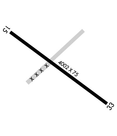
| Lat: N 4454.6 Long: W 06700.8 Elev: 45 Var: +16 Longest Runway: 4002 | ||
| AWOS: 122.8 CTAF: 122.8 | ||
| ||||||||||||||||||||||||||||||||||||||||||||
| ||||||||||||||||||||||||||||||||||||||||||||
| ||||||||||||||||||||||||||||||||||||||||||||
| Rwy | Rwy | |||||||
| 4002x75 | 4002' | 4002x75 | 4002' | |||||
| Runway ID | Single Wheel | Double Wheel | Double Tandem Wheel | Dual Double Wheel |
| 14/32 | 30,000 | N/A | N/A | N/A |
| These numbers are Advisory and are not limits. The Airport Manager should have more accurate Weight Limits | ||||
 Airport Diagram might not be current. | |
| Facility Name: | EASTPORT MUNI |
| City Name: | EASTPORT |
| County: | WASHINGTON |
| State abbrev: | ME |
| State Name: | MAINE |
| Ownership: | PUBLICLY OWNED |
| Use: | OPEN TO THE PUBLIC |
| Owner's Name: | CITY OF EASTPORT |
| Address: | 22 WASHINGTON ST |
| EASTPORT, ME 04631 | |
| Owner's Phone: | 207-853-2300 |
| Manager's Name: | VICTORIA GANZ |
| Address: | 1 AIRPORT WAY |
| EASTPORT, ME 04631 | |
| Phone: | 207-214-4751 |
| FAA Region: | NEW ENGLAND |
| FAA Field Office: | NONE |
| Date | Sunrise | Sunset |
|---|---|---|
| 05/22/26 Friday | 4:52 | 19:58 |
| 05/23/26 Saturday | 4:51 | 19:59 |
| 05/24/26 Sunday | 4:51 | 20:00 |
| 05/25/26 Monday | 4:50 | 20:01 |
| 05/26/26 Tuesday | 4:49 | 20:02 |
| 05/27/26 Wednesday | 4:48 | 20:03 |
| 05/28/26 Thursday | 4:48 | 20:03 |
| 05/29/26 Friday | 4:47 | 20:04 |
| 05/30/26 Saturday | 4:46 | 20:05 |
| 05/31/26 Sunday | 4:46 | 20:06 |
| 06/01/26 Monday | 4:45 | 20:07 |
| 06/02/26 Tuesday | 4:44 | 20:08 |
| 06/03/26 Wednesday | 4:44 | 20:09 |
| 06/04/26 Thursday | 4:44 | 20:09 |
| Airport Attendance Schedule | 7 Days A Week ON CALL; CONTACT AIRPORT MANAGER AT 207-214-4751 |
| Airport Status | OPERATIONAL (This Status can change at any time - please check NOTAMS) |
| Airport Lighting Schedule | ACTVT REIL RWY 14 & 32; PAPI RWY 14 & 32; MIRL RWY 14/32- 2 CLICKS - CTAF. |
| Airport Storage Available | Tie Downs |
| Extra Services Available | NONE |
| Wind Indicator | YES - (lighted) |
| Control Tower | NO |
| CTAF Frequency | 122.800 |
| Unicom Frequency | 122.800 |
| Rotating Beacon Color | WG |
| Segmented Circle | NO |
| Landing Fee | NO |
| Airport Inspected | STATE - performed by PRIVATE CONTRACT PERSONNEL |
| Inspection Date | 08/21/2023 |
| Type of Fuel Available | Grade 100LL, JET A |
| Airframe Repair Service | MAJOR |
| Power Plant Repair Service | MAJOR |
| Latitude | N4454.6 |
| Longitude | W06700.8 (ESTIMATED) |
| Arpt Elevation | 45ft (SURVEYED) |
| Magnetic Variation | 16W |
| 1 miles W | of EASTPORT |
| Traffic Pattern Altitude | |
| Sectional Chart | HALIFAX |
| Operations (Reported) | Yearly | Avg. Daily |
|---|---|---|
| General Aviation Transient | 0 | 0 |
| General Aviation Local | 0 | 0 |
| Air Taxi | 0 | 0 |
| Commerical | 0 | 0 |
| Commuter | 0 | 0 |
| Military | 0 | 0 |
| Aircraft based on Field | |
|---|---|
| General Aviation Singles | 0 |
| General Aviation Multi | 0 |
| Jet Aircraft | 0 |
| General Aviation Helicopters | 0 |
| Military Aircraft | 0 |
| Gliders | 0 |
| Ultralights | 0 |
| FSS on field | NO |
| FSS tie-in | BANGOR |
| FSS Phone | 1-800-WX-BRIEF |
| Who issues Notams | EPM |
| Notam D service at airport | YES |
| ARTCC Name | BOSTON |
| Airport Certification | |
| Aircraft Rescue & Firefighting Index | None |
| Airport of Entry | No |
| Custom Landing Rights | YES |
| Joint Civil/Military | No |
| Military Landing rights | YES |
| NATIONAL PLAN OF INTEGRATED AIRPORT SYSTEMS (NPIAS) |
| GRANT AGREEMENT HAS EXPIRED; HOWEVER, AGREEMENT REMAINS IN EFFECT FOR THIS FACILITY AS LONG AS IT IS PUBLIC USE. |
| AGREEMENT UNDER DLAND OR DCLA HAS EXPIRED. |
| DEER & NMRS BIRDS ON & INVOF RWY. |
| REQ CUST AT 207-853-4313. |
| 24 HR SELF-SVC FUEL AVBL WITH CREDIT CARD. |
| 40-50 FT OBSTN LGTS ON POLES 250 FT R OF CNTRLN NEAR RWY 14 END & APCH AREA. |
| FOR CD CTC BOSTON ARTCC AT 603-879-6859. |
| JET-A FUEL PUMP LMTD TO OVR WING GRAVITY RFLG OPS. |
Airport Communications & Frequencies:
| |||||||||
| Runway: 14 | Runway: 32 | ||
| Mag heading: | 143° | Mag heading: | 323° |
| Rwy Slope: | .26% Up | Rwy Slope: | -.26% Down |
| Approach: | Approach: | ||
| Pattern: | Left Traffic | Pattern: | Left Traffic |
| Markings: | NONPRECISION INSTRUMENT | Markings: | NONPRECISION INSTRUMENT |
| Marking Condition: | GOOD | Marking Condition: | GOOD |
| Arresting Dev: | Arresting Dev: | ||
| Lat & Long: | N4454.8 W06701.1 | Lat. & Long.: | N4454.4 W06700.4 |
| Elev: | 34.6 ft. MSL | Elev: | 45.2 ft. MSL |
| TCH: | 53 ft. AGL | TCH: | 44 ft. AGL |
| Visual Glide Path: | 3.10 degrees | Visual Glide Path: | 3.28 degrees |
| Displaced Threshold: | No | Displaced Threshold: | No |
| Touchdown Zone: | YES | Touchdown Zone: | YES |
| Touchdown Elev.: | 43.8 feet | Touchdown Elev.: | 45.3 feet |
| Visual Glide Slope: | 2-Light PAPI on LEFT side of Runway; PAPI UNUSBL BYD 6 DEGS L OF CNTRLN. | Visual Glide Slope: | 2-Light PAPI on LEFT side of Runway |
| RVR Equipment: | RVR Equipment: | ||
| RVV Equipment: | NO | RVV Equipment: | NO |
| Approach Lights: | Approach Lights: | ||
| REIL: | YES | REIL: | YES |
| Centerline Lights: | NO | Centerline Lights: | NO |
| Touchdown lights: | NO | Touchdown lights: | NO |
| Runway Category: | Runway with a Non-precision Approach | Runway Category: | Runway with a Non-precision Approach |
| Declared Distances: | Declared Distances: | ||
| Obstructions: | TREE | Obstructions: | |
| Marked: | LIGHTED | Marked: | |
| Clearance slope: | CTLG OBSTN EXCEEDS A 45 DEG SLP. | Clearance slope: | 20:1 |
| Obstruction height: | 12 feet AGL | Obstruction height: | |
| Dist. from runway: | 205 feet | Dist. from runway: | |
| Centerline offset: | 75 left of centerline | Centerline offset: | |
| Comments: | 3-5 FT BRUSH 20-200 FT FM THR, 100-200 FT R OF CNTRLN; 8 FT BERM 0-125 FT FM THR, 190 FT R OF CNTRLNE; 6-8 FT BRUSH, 100-200 FT FM THR, 65-200 FT L CNTRLN. | Comments: | 3-9 FT WEEDS AND GRASS 100-200 FT FM THR, 75-250 FT R OF CNTRLN; 2-5 FT RISING TERRAIN 50-120 FT FM THR, 125 FT L OF CNTRLN. |
Thanks for using FltPlan.com
all rights reserved © 1999-2026 by Flight Plan LLC