
| DILLANT-HOPKINS KEENE NH |
| |
| Lat: N 4253.9 Long: W 07216.2 Elev: 488 Var: +15 Longest Runway: 6201 | ||
| Clr Del: 121.6 AWOS: 119.02 CTAF: 123.0 | ||
| ||||||
| ||||||
|
| Rwy | Rwy | |||||||
| 6201x100 | 6201' | 108.90 - 018° | 6201x100 | 6201' | ||||
| 4001x75 | 4001' | 4001x75 | 2901' | |||||
| Runway ID | Single Wheel | Double Wheel | Double Tandem Wheel | Dual Double Wheel |
| 02/20 | N/A | 60,000 | N/A | N/A |
| 14/32 | 25,000 | N/A | N/A | N/A |
| These numbers are Advisory and are not limits. The Airport Manager should have more accurate Weight Limits | ||||
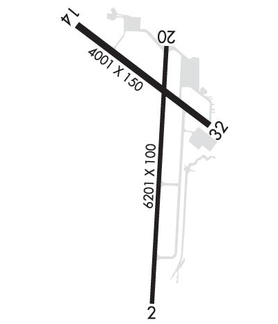 Airport Diagram might not be current. | |
| Facility Name: | DILLANT/HOPKINS |
| City Name: | KEENE |
| County: | CHESHIRE |
| State abbrev: | NH |
| State Name: | NEW HAMPSHIRE |
| Ownership: | PUBLICLY OWNED |
| Use: | OPEN TO THE PUBLIC |
| Owner's Name: | CITY OF KEENE |
| Address: | 3 WASHINGTON ST |
| KEENE, NH 03431 | |
| Owner's Phone: | 603-357-9835 |
| Manager's Name: | DAVID HICKLING |
| Address: | 80 AIRPORT RD |
| KEENE, NH 03431 | |
| Phone: | 603-357-9835 |
| FAA Region: | NEW ENGLAND |
| FAA Field Office: | NONE |
| Date | Sunrise | Sunset |
|---|---|---|
| 09/01/25 Monday | 6:13 | 19:24 |
| 09/02/25 Tuesday | 6:14 | 19:22 |
| 09/03/25 Wednesday | 6:15 | 19:21 |
| 09/04/25 Thursday | 6:17 | 19:19 |
| 09/05/25 Friday | 6:18 | 19:17 |
| 09/06/25 Saturday | 6:19 | 19:15 |
| 09/07/25 Sunday | 6:20 | 19:14 |
| 09/08/25 Monday | 6:21 | 19:12 |
| 09/09/25 Tuesday | 6:22 | 19:10 |
| 09/10/25 Wednesday | 6:23 | 19:08 |
| 09/11/25 Thursday | 6:24 | 19:07 |
| 09/12/25 Friday | 6:25 | 19:05 |
| 09/13/25 Saturday | 6:26 | 19:03 |
| 09/14/25 Sunday | 6:27 | 19:01 |
| Airport Attendance Schedule | MON-FRI 0700-1900, SAT-SUN 0700-1700 |
| Airport Status | OPERATIONAL (This Status can change at any time - please check NOTAMS) |
| Airport Lighting Schedule | ACTVT MALSR RWY 02; HIRL RWY 02/20; MIRL RWY 14/32 - CTAF. |
| Airport Storage Available | Tie Downs, Hanger |
| Extra Services Available | Charter, Flight Instruction, Aircraft Rental, Aircraft Sales |
| Wind Indicator | YES - (lighted) |
| Control Tower | NO |
| CTAF Frequency | 123.000 |
| Unicom Frequency | 123.000 |
| Rotating Beacon Color | WG |
| Segmented Circle | YES |
| Landing Fee | YES; LDG FEE FOR ALL TURBINE PWRD ACFT. |
| Airport Inspected | STATE - performed by STATE AERONAUTICAL PERSONNEL |
| Inspection Date | 08/28/2024 |
| Type of Fuel Available | Grade 100LL, JET A (freeze point -40C); -10100LL AVBL 24 HRS WITH CREDIT CARD. FOR JET FUEL AFT HRS CALL 603-357-7600. |
| Airframe Repair Service | MAJOR |
| Power Plant Repair Service | MAJOR |
| Latitude | N4253.9 |
| Longitude | W07216.2 (ESTIMATED) |
| Arpt Elevation | 488ft (SURVEYED) |
| Magnetic Variation | 15W |
| 2 miles S | of KEENE |
| Traffic Pattern Altitude | |
| Sectional Chart | NEW YORK |
| Operations (Reported) | Yearly | Avg. Daily |
|---|---|---|
| General Aviation Transient | 0 | 0 |
| General Aviation Local | 0 | 0 |
| Air Taxi | 0 | 0 |
| Commerical | 0 | 0 |
| Commuter | 0 | 0 |
| Military | 0 | 0 |
| Aircraft based on Field | |
|---|---|
| General Aviation Singles | 0 |
| General Aviation Multi | 0 |
| Jet Aircraft | 0 |
| General Aviation Helicopters | 0 |
| Military Aircraft | 0 |
| Gliders | 0 |
| Ultralights | 0 |
| FSS on field | NO |
| FSS tie-in | BANGOR |
| FSS Phone | 1-800-WX-BRIEF |
| Who issues Notams | EEN |
| Notam D service at airport | YES |
| ARTCC Name | BOSTON |
| Airport Certification | |
| Aircraft Rescue & Firefighting Index | None |
| Airport of Entry | No |
| Custom Landing Rights | No |
| Joint Civil/Military | No |
| Military Landing rights | YES |
| NATIONAL PLAN OF INTEGRATED AIRPORT SYSTEMS (NPIAS) |
| GRANT AGREEMENTS UNDER FAAP/ADAP/AIP |
| ASSURANCES PURSUANT TO TITLE VI, CIVIL RIGHTS ACT OF 1964 |
| AGREEMENT UNDER DLAND OR DCLA HAS EXPIRED. |
| WILDLIFE ON & INVOF ARPT. |
| NOISE ABATEMENT PROC: HEL TFC AVOID RESIDENTIAL AREAS DRCTLY N OF RWY 02-20 & SW OF ARPT. HEL TFC LIMIT MULT CLSD PAT OPS. |
| FOR CD IF UNA TO CTC ON FSS FREQ, CTC BOSTON ARTCC AT 603-879-6859. |
| COLD TEMPERATURE AIRPORT. ALTITUDE CORRECTION REQUIRED AT OR BELOW -20C. |
| NO ENG RUN-UPS ON TRML NW APN. |
| GRASS AREAS NOT MNTND FOR TKOFS & LDGS. |
Airport Communications & Frequencies:
| |||||||||
| Runway: 02 | Runway: 20 | ||
| Mag heading: | 18° | Mag heading: | 198° |
| Rwy Slope: | -.09% Down | Rwy Slope: | .09% Up |
| Approach: | ILS | Approach: | |
| Pattern: | Left Traffic | Pattern: | Left Traffic |
| Markings: | PRECISION INSTRUMENT | Markings: | BASIC |
| Marking Condition: | GOOD | Marking Condition: | GOOD |
| Arresting Dev: | Arresting Dev: | ||
| Lat & Long: | N4253.2 W07216.3 | Lat. & Long.: | N4254.3 W07216.2 |
| Elev: | 488.0 ft. MSL | Elev: | 482.3 ft. MSL |
| TCH: | 39 ft. AGL | TCH: | 50 ft. AGL |
| Visual Glide Path: | 3.00 degrees | Visual Glide Path: | 3.00 degrees |
| Displaced Threshold: | No | Displaced Threshold: | No |
| Touchdown Zone: | YES | Touchdown Zone: | YES |
| Touchdown Elev.: | 488.0 feet | Touchdown Elev.: | 482.3 feet |
| Visual Glide Slope: | 4-Light PAPI on LEFT side of Runway | Visual Glide Slope: | 4-Light PAPI on LEFT side of Runway; PAPI OTS INDEFLY. |
| RVR Equipment: | RVR Equipment: | ||
| RVV Equipment: | NO | RVV Equipment: | NO |
| Approach Lights: | MALSR - 1,400 foot medium intensity approach lighting system with runway alignment indicator lights | Approach Lights: | |
| REIL: | NO | REIL: | NO |
| Centerline Lights: | NO | Centerline Lights: | NO |
| Touchdown lights: | NO | Touchdown lights: | NO |
| Runway Category: | Precision Instrument Runway | Runway Category: | Runway with a Visual Approach |
| Declared Distances: | Declared Distances: | ||
| Obstructions: | TREE | Obstructions: | TREES |
| Marked: | NOT Marked/Lighted | Marked: | NOT Marked/Lighted |
| Clearance slope: | 11:1 | Clearance slope: | 13:1 |
| Obstruction height: | 70 feet AGL | Obstruction height: | 112 feet AGL |
| Dist. from runway: | 974 feet | Dist. from runway: | 1665 feet |
| Centerline offset: | 540 left of centerline | Centerline offset: | 541 feet right of centerline |
| Comments: | Comments: |
| Runway: 14 | Runway: 32 | ||
| Mag heading: | 142° | Mag heading: | 322° |
| Rwy Slope: | .26% Up | Rwy Slope: | -.26% Down |
| Approach: | Approach: | ||
| Pattern: | Left Traffic | Pattern: | Left Traffic |
| Markings: | BASIC | Markings: | BASIC |
| Marking Condition: | GOOD | Marking Condition: | GOOD |
| Arresting Dev: | Arresting Dev: | ||
| Lat & Long: | N4254.3 W07216.7 | Lat. & Long.: | N4253.9 W07215.9 |
| Elev: | 471.5 ft. MSL | Elev: | 481.9 ft. MSL |
| TCH: | TCH: | ||
| Visual Glide Path: | Visual Glide Path: | ||
| Displaced Threshold: | No | Displaced Threshold: | 1100 feet |
| Touchdown Zone: | YES | Touchdown Zone: | YES |
| Touchdown Elev.: | 475.8 feet | Touchdown Elev.: | 477.6 feet |
| Visual Glide Slope: | Visual Glide Slope: | ||
| RVR Equipment: | RVR Equipment: | ||
| RVV Equipment: | NO | RVV Equipment: | NO |
| Approach Lights: | Approach Lights: | ||
| REIL: | YES | REIL: | YES |
| Centerline Lights: | NO | Centerline Lights: | NO |
| Touchdown lights: | NO | Touchdown lights: | NO |
| Runway Category: | Runway with a Visual Approach | Runway Category: | Runway with a Visual Approach |
| Declared Distances: | Declared Distances: | ||
| Obstructions: | TREES | Obstructions: | TREES |
| Marked: | NOT Marked/Lighted | Marked: | NOT Marked/Lighted |
| Clearance slope: | 15:1 | Clearance slope: | 6:1; APCH RATIO 25:1 TO DTHR. |
| Obstruction height: | 10 feet AGL | Obstruction height: | 48 feet AGL |
| Dist. from runway: | 355 feet | Dist. from runway: | 522 feet |
| Centerline offset: | 37 right of centerline | Centerline offset: | 101 feet right of centerline |
| Comments: | Comments: |
Thanks for using FltPlan.com
all rights reserved © 1999-2025 by Flight Plan LLC
