
| SUMMERVILLE SUMMERVILLE SC |
| |
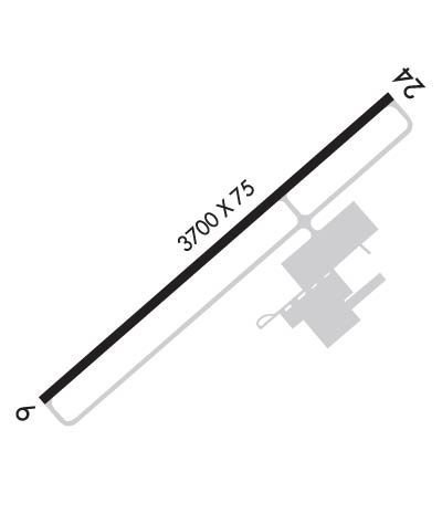
| Lat: N 3303.7 Long: W 08016.9 Elev: 56 Var: +07 Longest Runway: 5000 | ||
| AWOS: 119.57 CTAF: 123.0 | ||
| ||||||
| ||||||
|
| Rwy | Rwy | |||||||
| 5000x75 | 5000' | 5000x75 | 5000' | |||||
| Runway ID | Single Wheel | Double Wheel | Double Tandem Wheel | Dual Double Wheel |
| 06/24 | 19,500 | 31,000 | N/A | N/A |
| These numbers are Advisory and are not limits. The Airport Manager should have more accurate Weight Limits | ||||
 Airport Diagram might not be current. | |
| Facility Name: | SUMMERVILLE |
| City Name: | SUMMERVILLE |
| County: | DORCHESTER |
| State abbrev: | SC |
| State Name: | SOUTH CAROLINA |
| Ownership: | PUBLICLY OWNED |
| Use: | OPEN TO THE PUBLIC |
| Owner's Name: | DORCHESTER COUNTY |
| Address: | BOX 416 |
| ST. GEORGE, SC 29477 | |
| Owner's Phone: | 843-806-1180 |
| Manager's Name: | JEFFREY CRAVEN |
| Address: | 898 GREYBACK RD, P.O. BOX 3 |
| SUMMERVILLE, SC 29483 | |
| Phone: | 843-867-3927 |
| FAA Region: | SOUTHERN |
| FAA Field Office: | ATL |
| Date | Sunrise | Sunset |
|---|---|---|
| 01/17/26 Saturday | 7:24 | 17:39 |
| 01/18/26 Sunday | 7:24 | 17:40 |
| 01/19/26 Monday | 7:23 | 17:41 |
| 01/20/26 Tuesday | 7:23 | 17:42 |
| 01/21/26 Wednesday | 7:23 | 17:43 |
| 01/22/26 Thursday | 7:22 | 17:44 |
| 01/23/26 Friday | 7:22 | 17:45 |
| 01/24/26 Saturday | 7:21 | 17:46 |
| 01/25/26 Sunday | 7:21 | 17:47 |
| 01/26/26 Monday | 7:20 | 17:47 |
| 01/27/26 Tuesday | 7:20 | 17:48 |
| 01/28/26 Wednesday | 7:19 | 17:49 |
| 01/29/26 Thursday | 7:19 | 17:50 |
| 01/30/26 Friday | 7:18 | 17:51 |
| Airport Attendance Schedule | MON - FRI 0800 - 1800, SAT - SUN 0830 - 1700 |
| Airport Status | OPERATIONAL (This Status can change at any time - please check NOTAMS) |
| Airport Lighting Schedule | MIRL RWY 06/24 OPER DUSK-2200; AFTER 2200 ACTVT - CTAF. |
| Airport Storage Available | Tie Downs |
| Extra Services Available | Flight Instruction |
| Wind Indicator | YES - (lighted) |
| Control Tower | NO |
| CTAF Frequency | 123.000 |
| Unicom Frequency | 123.000 |
| Rotating Beacon Color | WG |
| Segmented Circle | YES |
| Landing Fee |
| Airport Inspected | STATE - performed by STATE AERONAUTICAL PERSONNEL |
| Inspection Date | 05/23/2023 |
| Type of Fuel Available | Grade 100LL, JET A (freeze point -40C) |
| Airframe Repair Service | MAJOR |
| Power Plant Repair Service | MAJOR |
| Latitude | N3303.7 |
| Longitude | W08016.9 (ESTIMATED) |
| Arpt Elevation | 55ft (SURVEYED) |
| Magnetic Variation | 07W |
| 5 miles NW | of SUMMERVILLE |
| Traffic Pattern Altitude | |
| Sectional Chart | CHARLOTTE |
| Operations (Reported) | Yearly | Avg. Daily |
|---|---|---|
| General Aviation Transient | 0 | 0 |
| General Aviation Local | 0 | 0 |
| Air Taxi | 0 | 0 |
| Commerical | 0 | 0 |
| Commuter | 0 | 0 |
| Military | 0 | 0 |
| Aircraft based on Field | |
|---|---|
| General Aviation Singles | 0 |
| General Aviation Multi | 0 |
| Jet Aircraft | 0 |
| General Aviation Helicopters | 0 |
| Military Aircraft | 0 |
| Gliders | 0 |
| Ultralights | 0 |
| FSS on field | NO |
| FSS tie-in | ANDERSON |
| FSS Phone | 1-800-WX-BRIEF |
| Who issues Notams | AND |
| Notam D service at airport | YES |
| ARTCC Name | JACKSONVILLE |
| Airport Certification | |
| Aircraft Rescue & Firefighting Index | None |
| Airport of Entry | No |
| Custom Landing Rights | No |
| Joint Civil/Military | No |
| Military Landing rights | No |
| NATIONAL PLAN OF INTEGRATED AIRPORT SYSTEMS (NPIAS) |
| GRANT AGREEMENTS UNDER FAAP/ADAP/AIP |
| ASSURANCES PURSUANT TO TITLE VI, CIVIL RIGHTS ACT OF 1964 |
| FOR MAIN FBO CALL (843) 806-1180. |
| BANNER TOWING 1500/BLO INTMT DAILY, SOUTH SIDE RWY 06/24. |
| FOR CD CTC CHARLESTON APCH AT 843-414-2832. |
| MOWING OPS ON WEDS NEAR ACTV RWYS/TWYS DURG GROWING SEASON. |
| FOR MAINT AND RPR FBO CALL 843-851-0970. |
| VISIT DORCHESTERCOUNTYSC.GOV/GOVERNMENT/ADMINISTRATIVE-SERVICES/AIRPORT FOR AIRFIELD STS AND OTHER ARPT INFO. |
Airport Communications & Frequencies:
| ||||||||||||||
| Runway: 06 | Runway: 24 | ||
| Mag heading: | 56° | Mag heading: | 236° |
| Rwy Slope: | .30% Up | Rwy Slope: | -.30% Down |
| Approach: | Approach: | ||
| Pattern: | Right Traffic | Pattern: | Left Traffic |
| Markings: | NONPRECISION INSTRUMENT | Markings: | NONPRECISION INSTRUMENT |
| Marking Condition: | GOOD | Marking Condition: | GOOD |
| Arresting Dev: | Arresting Dev: | ||
| Lat & Long: | N3303.5 W08017.2 | Lat. & Long.: | N3304.0 W08016.5 |
| Elev: | 38.4 ft. MSL | Elev: | 53.5 ft. MSL |
| TCH: | TCH: | ||
| Visual Glide Path: | Visual Glide Path: | ||
| Displaced Threshold: | No | Displaced Threshold: | No |
| Touchdown Zone: | YES | Touchdown Zone: | YES |
| Touchdown Elev.: | 52.6 feet | Touchdown Elev.: | 55.8 feet |
| Visual Glide Slope: | Visual Glide Slope: | ||
| RVR Equipment: | RVR Equipment: | ||
| RVV Equipment: | NO | RVV Equipment: | NO |
| Approach Lights: | Approach Lights: | ||
| REIL: | NO | REIL: | NO |
| Centerline Lights: | NO | Centerline Lights: | NO |
| Touchdown lights: | NO | Touchdown lights: | NO |
| Runway Category: | Runway with a Non-precision Approach having visibility minimums greater than 3/4 mile | Runway Category: | Runway with a Non-precision Approach having visibility minimums greater than 3/4 mile |
| Declared Distances: | Declared Distances: | ||
| Obstructions: | TREES | Obstructions: | TREE |
| Marked: | NOT Marked/Lighted | Marked: | NOT Marked/Lighted |
| Clearance slope: | 34:1 | Clearance slope: | 18:1 |
| Obstruction height: | Obstruction height: | 75 feet AGL | |
| Dist. from runway: | Dist. from runway: | 1560 feet | |
| Centerline offset: | Centerline offset: | 221 feet right of centerline | |
| Comments: | Comments: |
Thanks for using FltPlan.com
all rights reserved © 1999-2026 by Flight Plan LLC
