
| DEVILS LAKE RGNL DEVILS LAKE ND |
| |
| Lat: N 4807.0 Long: W 09854.6 Elev: 1469 Var: -07 Longest Runway: 6400 | ||
| AWOS: 125.87 CTAF: 122.8 | ||
| ||||||||||||||||||||||||||||||||||||||||||||||||||||||||||||||||||||
| ||||||||||||||||||||||||||||||||||||||||||||||||||||||||||||||||||||
| ||||||||||||||||||||||||||||||||||||||||||||||||||||||||||||||||||||
| ||||||||||||||||||||||||||||||||||||||||||||||||||||||||||||||||||||
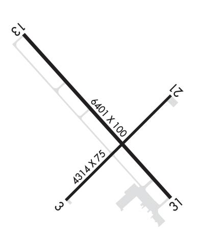
| Rwy | Rwy | |||||||
| 4314x75 | 4314' | 4314x75 | 4314' | |||||
| 6400x100 | 6400' | 6400x100 | 6400' | 108.70 - 311° | ||||
| Runway ID | Single Wheel | Double Wheel | Double Tandem Wheel | Dual Double Wheel |
| 03/21 | 30,000 | N/A | N/A | N/A |
| 13/31 | 75,000 | 130,000 | 190,000 | N/A |
| These numbers are Advisory and are not limits. The Airport Manager should have more accurate Weight Limits | ||||
 Airport Diagram might not be current. | |
| Facility Name: | DEVILS LAKE RGNL |
| City Name: | DEVILS LAKE |
| County: | RAMSEY |
| State abbrev: | ND |
| State Name: | NORTH DAKOTA |
| Ownership: | PUBLICLY OWNED |
| Use: | OPEN TO THE PUBLIC |
| Owner's Name: | DEVILS LAKE AIRPORT AUTHORITY |
| Address: | 106 NATIONAL GUARD ST NW |
| DEVILS LAKE, ND 58301-8993 | |
| Owner's Phone: | 701-662-5833 |
| Manager's Name: | SCOTT CRUSE |
| Address: | 106 NATIONAL GUARD ST NW |
| DEVILS LAKE, ND 58301-8993 | |
| Phone: | 701-662-5833 |
| FAA Region: | GREAT LAKES |
| FAA Field Office: | DMA |
| Date | Sunrise | Sunset |
|---|---|---|
| 09/24/25 Wednesday | 7:25 | 19:30 |
| 09/25/25 Thursday | 7:26 | 19:28 |
| 09/26/25 Friday | 7:28 | 19:26 |
| 09/27/25 Saturday | 7:29 | 19:23 |
| 09/28/25 Sunday | 7:30 | 19:21 |
| 09/29/25 Monday | 7:32 | 19:19 |
| 09/30/25 Tuesday | 7:33 | 19:17 |
| 10/01/25 Wednesday | 7:35 | 19:15 |
| 10/02/25 Thursday | 7:36 | 19:13 |
| 10/03/25 Friday | 7:37 | 19:11 |
| 10/04/25 Saturday | 7:39 | 19:09 |
| 10/05/25 Sunday | 7:40 | 19:07 |
| 10/06/25 Monday | 7:42 | 19:05 |
| 10/07/25 Tuesday | 7:43 | 19:03 |
| Airport Attendance Schedule | 7 Days A Week 0700-1800; FOR ATNDT AFT HRS CALL 701-520-0229. |
| Airport Status | OPERATIONAL (This Status can change at any time - please check NOTAMS) |
| Airport Lighting Schedule | ACTVT OR INCR INTST MALSR RWY 31; REIL RWY 03, 13, & 21; PAPI RWY 13/31; HIRL RWY 13/31, MIRL RWY 03/21 - CTAF. |
| Airport Storage Available | Tie Downs, Hanger |
| Extra Services Available | Air Freight, Crop Dusting, Air Ambulance, Charter, Flight Instruction, Aircraft Rental, Aircraft Sales, Annual Surveying |
| Wind Indicator | YES - (lighted) |
| Control Tower | NO |
| CTAF Frequency | 122.800 |
| Unicom Frequency | 122.800 |
| Rotating Beacon Color | WG |
| Segmented Circle | YES |
| Landing Fee | NO |
| Airport Inspected | STATE - performed by FAA AIRPORTS FIELD PERSONNEL |
| Inspection Date | 09/23/2024 |
| Type of Fuel Available | Grade 100LL, JET A (freeze point -40C); -A FUEL AVBL IREG HRS CALL 701-520-0229; SELF SVC AVGAS AVBL H24. |
| Airframe Repair Service | MAJOR |
| Power Plant Repair Service | MAJOR |
| Latitude | N4807.0 |
| Longitude | W09854.6 (ESTIMATED) |
| Arpt Elevation | 1469ft (SURVEYED) |
| Magnetic Variation | 07E |
| 2 miles W | of DEVILS LAKE |
| Traffic Pattern Altitude | |
| Sectional Chart | TWIN CITIES |
| Operations (Reported) | Yearly | Avg. Daily |
|---|---|---|
| General Aviation Transient | 0 | 0 |
| General Aviation Local | 0 | 0 |
| Air Taxi | 0 | 0 |
| Commerical | 0 | 0 |
| Commuter | 0 | 0 |
| Military | 0 | 0 |
| Aircraft based on Field | |
|---|---|
| General Aviation Singles | 0 |
| General Aviation Multi | 0 |
| Jet Aircraft | 0 |
| General Aviation Helicopters | 0 |
| Military Aircraft | 0 |
| Gliders | 0 |
| Ultralights | 0 |
| FSS on field | NO |
| FSS tie-in | GRAND FORKS |
| FSS Phone | 1-800-WX-BRIEF |
| Who issues Notams | DVL |
| Notam D service at airport | YES |
| ARTCC Name | MINNEAPOLIS |
| Airport Certification | AIRPORT RECEIVING SCHEDULED AIR CARRIER SERVICE FROM CARRIERS CERTIFICATED BY THE CIVIL AERONAUTICS BOARD; 48 HRS PPR FOR UNSKED ACFT OPS WITH MORE THAN 30 PSGRS CALL AMGR 701-662-5833. |
| Aircraft Rescue & Firefighting Index | AIRPORT HAS A CERTIFICATE UNDER CFR PART 139 |
| Airport of Entry | No |
| Custom Landing Rights | No |
| Joint Civil/Military | No |
| Military Landing rights | YES |
| NATIONAL PLAN OF INTEGRATED AIRPORT SYSTEMS (NPIAS) |
| GRANT AGREEMENTS UNDER FAAP/ADAP/AIP |
| ASSURANCES PURSUANT TO TITLE VI, CIVIL RIGHTS ACT OF 1964 |
| AGREEMENT UNDER DLAND OR DCLA HAS EXPIRED. |
| NUMEROUS WATERFOWL & OTHER BIRDS; DEER & JACK RABBITS ON & INVOF ARPT. |
| FOR CD IF UNA TO CTC ON FSS FREQ, CTC MINNEAPOLIS ARTCC AT 651-463-5588. |
| RWY 03/2 1 RWY 03/21 NOT AVBL FOR PART 121/PART 380 OPS WITH SKED PAX CARRYING OPS MORE THAN 9 PAX SEATS & NON-SKED PAX CARRYING OPS MORE THAN 30 PAX SEATS. |
| RWY 03/2 1 PCR VALUE: 245/F/D/X/T |
| RWY 13/3 1 PCR VALUE: 337/F/D/X/T |
Airport Communications & Frequencies:
| |||||||||
| Runway: 03 | Runway: 21 | ||
| Mag heading: | 38° | Mag heading: | 218° |
| Rwy Slope: | -.21% Down | Rwy Slope: | .21% Up |
| Approach: | Approach: | ||
| Pattern: | Left Traffic | Pattern: | Left Traffic |
| Markings: | NONPRECISION INSTRUMENT | Markings: | NONPRECISION INSTRUMENT |
| Marking Condition: | GOOD | Marking Condition: | GOOD |
| Arresting Dev: | Arresting Dev: | ||
| Lat & Long: | N4806.7 W09854.9 | Lat. & Long.: | N4807.2 W09854.1 |
| Elev: | 1449.9 ft. MSL | Elev: | 1441.0 ft. MSL |
| TCH: | 25 ft. AGL | TCH: | 25 ft. AGL |
| Visual Glide Path: | 3.00 degrees | Visual Glide Path: | 3.00 degrees |
| Displaced Threshold: | No | Displaced Threshold: | No |
| Touchdown Zone: | YES | Touchdown Zone: | YES |
| Touchdown Elev.: | 1449.9 feet | Touchdown Elev.: | 1449.2 feet |
| Visual Glide Slope: | 2-Light PAPI on LEFT side of Runway | Visual Glide Slope: | 2-Light PAPI on LEFT side of Runway |
| RVR Equipment: | RVR Equipment: | ||
| RVV Equipment: | NO | RVV Equipment: | NO |
| Approach Lights: | Approach Lights: | ||
| REIL: | YES | REIL: | YES |
| Centerline Lights: | NO | Centerline Lights: | NO |
| Touchdown lights: | NO | Touchdown lights: | NO |
| Runway Category: | Runway with a Non-precision Approach | Runway Category: | Runway with a Non-precision Approach |
| Declared Distances: | TORA:4314' TODA:4314' ASDA:4314' LDA:4314' | Declared Distances: | TORA:4314' TODA:4314' ASDA:4314' LDA:4314' |
| Obstructions: | ROAD | Obstructions: | TREE |
| Marked: | NOT Marked/Lighted | Marked: | NOT Marked/Lighted |
| Clearance slope: | 26:1 | Clearance slope: | 40:1 |
| Obstruction height: | 35 feet AGL | Obstruction height: | 38 feet AGL |
| Dist. from runway: | 1119 feet | Dist. from runway: | 1523 feet |
| Centerline offset: | 384 left of centerline | Centerline offset: | 131 feet right of centerline |
| Comments: | Comments: |
| Runway: 13 | Runway: 31 | ||
| Mag heading: | 131° | Mag heading: | 311° |
| Rwy Slope: | -.41% Down | Rwy Slope: | .41% Up |
| Approach: | Approach: | ILS | |
| Pattern: | Left Traffic | Pattern: | Left Traffic |
| Markings: | NONPRECISION INSTRUMENT | Markings: | PRECISION INSTRUMENT |
| Marking Condition: | GOOD | Marking Condition: | GOOD |
| Arresting Dev: | Arresting Dev: | ||
| Lat & Long: | N4807.4 W09855.2 | Lat. & Long.: | N4806.7 W09854.1 |
| Elev: | 1469.4 ft. MSL | Elev: | 1443.3 ft. MSL |
| TCH: | 45 ft. AGL | TCH: | 44 ft. AGL |
| Visual Glide Path: | 3.00 degrees | Visual Glide Path: | 3.00 degrees |
| Displaced Threshold: | No | Displaced Threshold: | No |
| Touchdown Zone: | YES | Touchdown Zone: | YES |
| Touchdown Elev.: | 1469.4 feet | Touchdown Elev.: | 1450.1 feet |
| Visual Glide Slope: | 4-Light PAPI on LEFT side of Runway | Visual Glide Slope: | 4-Light PAPI on LEFT side of Runway |
| RVR Equipment: | RVR Equipment: | ||
| RVV Equipment: | NO | RVV Equipment: | NO |
| Approach Lights: | Approach Lights: | MALSR - 1,400 foot medium intensity approach lighting system with runway alignment indicator lights | |
| REIL: | YES | REIL: | NO |
| Centerline Lights: | NO | Centerline Lights: | NO |
| Touchdown lights: | NO | Touchdown lights: | NO |
| Runway Category: | D | Runway Category: | Precision Instrument Runway |
| Declared Distances: | TORA:6401' TODA:6401' ASDA:6401' LDA:6401' | Declared Distances: | TORA:6401' TODA:6401' ASDA:6401' LDA:6401' |
| Obstructions: | Obstructions: | BLDG | |
| Marked: | Marked: | NOT Marked/Lighted | |
| Clearance slope: | 34:1 | Clearance slope: | 41:1 |
| Obstruction height: | Obstruction height: | 29 feet AGL | |
| Dist. from runway: | Dist. from runway: | 1400 feet | |
| Centerline offset: | Centerline offset: | 650 feet left of centerline | |
| Comments: | Comments: |
Thanks for using FltPlan.com
all rights reserved © 1999-2025 by Flight Plan LLC


