| DETROIT METROPOLITAN WAYNE CO DETROIT MI |
| |
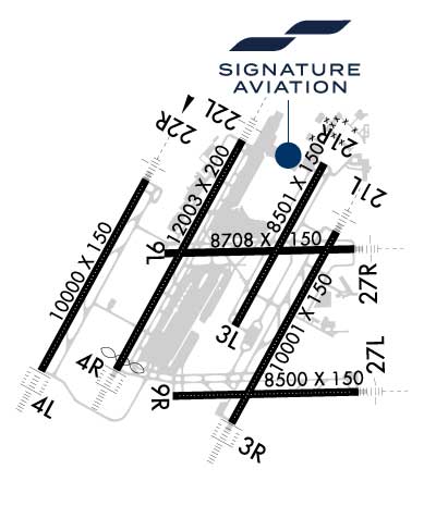
| Lat: N 4212.7 Long: W 08321.2 Elev: 645 Var: +07 Longest Runway: 12003 | ||
| Clr Del: 120.65 Dept. ATIS: 118.12 Arr. ATIS: 133.67 Ground: W121.8E119.45 Tower: W135.0 E118.4 | ||
| ||||||||||||||||||||||||||||||||||||||||||||||||||||||||||||||||||||
| ||||||||||||||||||||||||||||||||||||||||||||||||||||||||||||||||||||
| ||||||||||||||||||||||||||||||||||||||||||||||||||||||||||||||||||||
| FBOs at nearby airports who want your business: | |||||||||||
| |||||||||||
| Rwy | Rwy | |||||||
| 8501x150 | 8501' | 8501x150 | 8501' | |||||
| 10001x150 | 10001' | 111.50 - 035° | 10001x150 | 10001' | 111.50 - 215° | |||
| 10000x150 | 10000' | 111.95 - 035° | 10000x150 | 10000' | 111.95 - 215° | |||
| 12003x200 | 11494' | 110.70 - 035° | 12003x200 | 12003' | 110.70 - 215° | |||
| 8708x150 | 8708' | 8708x150 | 8708' | 108.50 - 275° | ||||
| 8500x150 | 8500' | 8500x150 | 8500' | 110.15 - 275° | ||||
| Runway ID | Single Wheel | Double Wheel | Double Tandem Wheel | Dual Double Wheel |
| 03L/21R | 120,000 | 250,000 | 550,000 | 1,000,000 |
| 03R/21L | 100,000 | 200,000 | 350,000 | 750,000 |
| 04L/22R | 100,000 | 200,000 | 350,000 | 750,000 |
| 04R/22L | 100,000 | 185,000 | 350,000 | N/A |
| 04X/22X | N/A | N/A | N/A | N/A |
| 09L/27R | 100,000 | 185,000 | 350,000 | N/A |
| 09R/27L | 100,000 | 185,000 | 350,000 | N/A |
| These numbers are Advisory and are not limits. The Airport Manager should have more accurate Weight Limits | ||||
 Airport Diagram might not be current. | |
| Facility Name: | DETROIT METRO WAYNE COUNTY |
| City Name: | DETROIT |
| County: | WAYNE |
| State abbrev: | MI |
| State Name: | MICHIGAN |
| Ownership: | PUBLICLY OWNED |
| Use: | OPEN TO THE PUBLIC |
| Owner's Name: | WAYNE COUNTY, MICHIGAN |
| Address: | 11050 ROGELL DR #602 |
| DETROIT, MI 48242-1144 | |
| Owner's Phone: | 734-942-3550 |
| Manager's Name: | CHAD NEWTON, INTERIM AMGR |
| Address: | 11050 ROGELL DR #602 |
| DETROIT, MI 48242-1144 | |
| Phone: | 734-942-3685 |
| FAA Region: | GREAT LAKES |
| FAA Field Office: | DET |
| Date | Sunrise | Sunset |
|---|---|---|
| 09/24/21 Friday | 7:23 | 19:28 |
| 09/25/21 Saturday | 7:24 | 19:26 |
| 09/26/21 Sunday | 7:25 | 19:24 |
| 09/27/21 Monday | 7:26 | 19:22 |
| 09/28/21 Tuesday | 7:27 | 19:21 |
| 09/29/21 Wednesday | 7:28 | 19:19 |
| 09/30/21 Thursday | 7:29 | 19:17 |
| 10/01/21 Friday | 7:30 | 19:15 |
| 10/02/21 Saturday | 7:31 | 19:14 |
| 10/03/21 Sunday | 7:32 | 19:12 |
| 10/04/21 Monday | 7:33 | 19:10 |
| 10/05/21 Tuesday | 7:35 | 19:08 |
| 10/06/21 Wednesday | 7:36 | 19:07 |
| 10/07/21 Thursday | 7:37 | 19:05 |
| Airport Attendance Schedule | CONTINUOUS |
| Airport Status | OPERATIONAL (This Status can change at any time - please check NOTAMS) |
| Airport Lighting Schedule | |
| Airport Storage Available | Tie Downs, Hanger |
| Extra Services Available | Air Freight, Cargo Handling, Charter |
| Wind Indicator | YES - (lighted) |
| Control Tower | YES |
| CTAF Frequency | |
| Unicom Frequency | 122.950 |
| Rotating Beacon Color | CLEAR-GREEN (Light Land Airport) |
| Segmented Circle | NO |
| Landing Fee | YES |
| Airport Inspected | FEDERAL - performed by FAA AIRPORTS FIELD PERSONNEL |
| Inspection Date | 08/23/2019 |
| Type of Fuel Available | Grade 100LL, JET A (freeze point -40C) |
| Airframe Repair Service | NONE |
| Power Plant Repair Service | NONE |
| Latitude | N4212.7 |
| Longitude | W08321.2 (ESTIMATED) |
| Arpt Elevation | 645ft (SURVEYED) |
| Magnetic Variation | 07W |
| 15 miles S | of DETROIT |
| Traffic Pattern Altitude | |
| Sectional Chart | DETROIT |
| Operations (Reported) | Yearly | Avg. Daily |
|---|---|---|
| General Aviation Transient | 6188 | 17 |
| General Aviation Local | 0 | 0 |
| Air Taxi | 71412 | 196 |
| Commerical | 315995 | 866 |
| Commuter | 0 | 0 |
| Military | 86 | 0 |
| Aircraft based on Field | |
|---|---|
| General Aviation Singles | 0 |
| General Aviation Multi | 0 |
| Jet Aircraft | 9 |
| General Aviation Helicopters | 0 |
| Military Aircraft | 0 |
| Gliders | 0 |
| Ultralights | 0 |
| FSS on field | NO |
| FSS tie-in | LANSING |
| FSS Phone | 1-800-WX-BRIEF |
| Who issues Notams | DTW |
| Notam D service at airport | YES |
| ARTCC Name | CLEVELAND |
| Airport Certification | AIRPORT RECEIVING SCHEDULED AIR CARRIER SERVICE FROM CARRIERS CERTIFICATED BY THE CIVIL AERONAUTICS BOARD |
| Aircraft Rescue & Firefighting Index | AIRPORT HAS A CERTIFICATE UNDER CFR PART 139 |
| Airport of Entry | YES |
| Custom Landing Rights | YES |
| Joint Civil/Military | No |
| Military Landing rights | YES |
| NATIONAL PLAN OF INTEGRATED AIRPORT SYSTEMS (NPIAS) |
| GRANT AGREEMENTS UNDER FAAP/ADAP/AIP |
| SURPLUS PROPERTY AGREEMENT UNDER PUBLIC LAW 289 |
| SURPLUS PROPERTY AGREEMENT UNDER REGULATION 16-WAA |
| ASSURANCES PURSUANT TO TITLE VI, CIVIL RIGHTS ACT OF 1964 |
| BRIGHTLY LIGHTED PARKING LOT 2.6 NM SW OF ARPT. |
| RY STATUS LGTS ARE IN OPN. |
| RWY VISUAL SCREEN 20 FT AGL 1150 FT S. AER 04R |
| PPR FOR B747-8 OPRS DUE TO CONSTRAINTS ON RWYS, TWYS AND RAMPS CTC AIRFIELD OPRS AT 734-942-3685. |
| ACFT WITH WINGSPAN GTR THAN 171 FT ARE RSTRD FM USING TWY P BTN TWY J & TWY P3. |
| ACFT WITH WINGSPAN GTR THAN 171 FT ARE RSTRD FM USING TWY H BTN TWY B & TWY F. |
| TURNING RSTRD TO WINGSPAN 135 FT OR LESS TWY G NORTH TO TWY V EAST. |
| DIVERSIONAIR CARRIERS WITHOUT A PRESENCE AT DTW SHOULD CTC AIRFIELD OPRS 734-942-3685 PRIOR TO DIVERTING TO THE EXTENT PRACTICAL AND PROVIDE COMPANY, FLT OPRS, CTC INFO, AIRCRAFT TYPE, PERSONS ONBOARD, INTERNATIONAL OR DOMESTIC, ANY GRND HANDLER AGGREEMENTS IN PLACE. |
| BE ALERT BIRDS, WATERFOWL, ON & INVOF ARPT. |
| AIRCRAFT WITH WINGSPAN GREATER THAN 171 FT CANNOT PASS EACH OTHER ON TWYS Y AND K BETWEEN TWYS U AND K6 INSUFFICIENT WINGTIP CLEARANCE. |
| TURNING RESTRICTION TWY B TO TWY K RESTRICTED TO AIRCRAFT WITH WINGSPAN 171 FT OR LESS. |
| AUTH TO CONDUCT SIMUL INDEPENDENT INSTR APCHS TO PARL RWY 04L/22R & 03R/21L WO FINAL MONITORS, RWY CNTRLNS SEPARATED BY 8800 FT. |
| ACFT ON TWY 'F' AND TWY 'V' DO NOT BLOCK FIRE STATION EXITS. |
| ASDE-X IN USE. OPERATE TRANSPONDERS WITH ALTITUDE REPORTING MODE AND ADS-B (IF EQUIPPED) ENABLED ON ALL AIRPORT SURFACES. |
| TAXI ON RWY 09L/27R LTD TO: EXITING FM RWY 04R/22L, 03L/21R, & 03R/21L EXC NO TAXI BTN RWY 03L/21R & TWY W; TWO-WAY TAXI BTN TWY Y & TWY M WHEN RED STOP BAR LGTS ARE LGTD AT RWY 04R/22L & 03L/21R OR WHEN BARRICADES ARE USED INSTEAD AT THE RESPECTIVE INTS. TAXI BTN SS-SR OR IN CONDS WITH VIS LESS THAN 1 SM RQRS GREEN CNTRLN LGT TO BE OPR. |
| RWY 04X/ 22XRY ID 04X/22X SUPPORTS SECOND ILS'S (I-BZB AND I-ALA) AT RY 04L/22R. |
Airport Communications & Frequencies:
| |||||||||||||||||||||||||||||||||||||||||||||||||||||||||||||||||
| Runway: 03L | Runway: 21R | ||
| Mag heading: | 36° | Mag heading: | 216° |
| Rwy Slope: | -.05% Down | Rwy Slope: | .05% Up |
| Approach: | Approach: | ||
| Pattern: | Left Traffic | Pattern: | Left Traffic |
| Markings: | NONPRECISION INSTRUMENT | Markings: | NONPRECISION INSTRUMENT |
| Marking Condition: | GOOD | Marking Condition: | GOOD |
| Arresting Dev: | Arresting Dev: | ||
| Lat & Long: | N4212.5 W08321.1 | Lat. & Long.: | N4213.7 W08320.2 |
| Elev: | 635.7 ft. MSL | Elev: | 631.4 ft. MSL |
| TCH: | 55 ft. AGL | TCH: | 55 ft. AGL |
| Visual Glide Path: | 3.00 degrees | Visual Glide Path: | 3.00 degrees |
| Displaced Threshold: | No | Displaced Threshold: | No |
| Touchdown Zone: | YES | Touchdown Zone: | YES |
| Touchdown Elev.: | 636.8 feet | Touchdown Elev.: | 634.4 feet |
| Visual Glide Slope: | 4-Light PAPI on RIGHT side of Runway; UNUSABLE 8 DEG LEFT/RIGHT COURSE. | Visual Glide Slope: | 4-Light PAPI on LEFT side of Runway |
| RVR Equipment: | TOUCHDOWN-ROLLOUT | RVR Equipment: | TOUCHDOWN-ROLLOUT |
| RVV Equipment: | NO | RVV Equipment: | NO |
| Approach Lights: | Approach Lights: | ||
| REIL: | YES | REIL: | YES |
| Centerline Lights: | YES | Centerline Lights: | YES |
| Touchdown lights: | NO | Touchdown lights: | NO |
| Runway Category: | Runway with a Visual Approach | Runway Category: | Runway with a Visual Approach |
| Declared Distances: | TORA:8501' TODA:8501' ASDA:8501' LDA:8501' | Declared Distances: | TORA:8501' TODA:8501' ASDA:8501' LDA:8501' |
| Obstructions: | POLE | Obstructions: | POLE |
| Marked: | NOT Marked/Lighted | Marked: | NOT Marked/Lighted |
| Clearance slope: | 26:1 | Clearance slope: | 50:1 |
| Obstruction height: | 19 feet AGL | Obstruction height: | 42 feet AGL |
| Dist. from runway: | 698 feet | Dist. from runway: | 2302 feet |
| Centerline offset: | 569 left of centerline | Centerline offset: | 179 feet right of centerline |
| Comments: | Comments: |
| Runway: 03R | Runway: 21L | ||
| Mag heading: | 36° | Mag heading: | 216° |
| Rwy Slope: | -.01% Down | Rwy Slope: | .01% Up |
| Approach: | ILS/DME | Approach: | ILS/DME |
| Pattern: | Left Traffic | Pattern: | Left Traffic |
| Markings: | PRECISION INSTRUMENT | Markings: | PRECISION INSTRUMENT |
| Marking Condition: | GOOD | Marking Condition: | GOOD |
| Arresting Dev: | Arresting Dev: | ||
| Lat & Long: | N4211.7 W08321.1 | Lat. & Long.: | N4213.2 W08320.0 |
| Elev: | 632.8 ft. MSL | Elev: | 631.8 ft. MSL |
| TCH: | 70 ft. AGL | TCH: | 80 ft. AGL |
| Visual Glide Path: | 3.00 degrees | Visual Glide Path: | 3.00 degrees |
| Displaced Threshold: | No | Displaced Threshold: | No |
| Touchdown Zone: | YES | Touchdown Zone: | YES |
| Touchdown Elev.: | 633.1 feet | Touchdown Elev.: | 632.3 feet |
| Visual Glide Slope: | 4-Light PAPI on RIGHT side of Runway | Visual Glide Slope: | 4-Light PAPI on LEFT side of Runway |
| RVR Equipment: | TOUCHDOWN-MIDFIELD-ROLLOUT | RVR Equipment: | TOUCHDOWN-MIDFIELD-ROLLOUT |
| RVV Equipment: | NO | RVV Equipment: | NO |
| Approach Lights: | ALSF2 - standard 2,400 foot high intensity approach lighting system with sequenced flashers, Category II or III; ALSF2 RQRD WHEN RVR/VSBLY IS 6000/1 MILE OR LESS. SSALR OPERD WHEN RVR/VSBLY IS 6000/1 MILE. | Approach Lights: | MALSR - 1,400 foot medium intensity approach lighting system with runway alignment indicator lights |
| REIL: | NO | REIL: | NO |
| Centerline Lights: | YES | Centerline Lights: | YES |
| Touchdown lights: | YES | Touchdown lights: | NO |
| Runway Category: | Precision Instrument Runway | Runway Category: | Precision Instrument Runway |
| Declared Distances: | TORA:10001' TODA:10001' ASDA:10001' LDA:10001' | Declared Distances: | TORA:10001' TODA:10001' ASDA:10001' LDA:10001' |
| Obstructions: | ROAD | Obstructions: | BERM |
| Marked: | NOT Marked/Lighted | Marked: | NOT Marked/Lighted |
| Clearance slope: | 41:1 | Clearance slope: | 17:1 |
| Obstruction height: | 22 feet AGL | Obstruction height: | 20 feet AGL |
| Dist. from runway: | 1119 feet | Dist. from runway: | 559 feet |
| Centerline offset: | 439 left of centerline | Centerline offset: | 523 feet right of centerline |
| Comments: | Comments: |
| Runway: 04L | Runway: 22R | ||
| Mag heading: | 36° | Mag heading: | 216° |
| Rwy Slope: | -.03% Down | Rwy Slope: | .03% Up |
| Approach: | ILS/DME | Approach: | ILS/DME |
| Pattern: | Left Traffic | Pattern: | Left Traffic |
| Markings: | PRECISION INSTRUMENT | Markings: | PRECISION INSTRUMENT |
| Marking Condition: | GOOD | Marking Condition: | GOOD |
| Arresting Dev: | Arresting Dev: | ||
| Lat & Long: | N4212.1 W08323.0 | Lat. & Long.: | N4213.6 W08322.0 |
| Elev: | 645.2 ft. MSL | Elev: | 642.1 ft. MSL |
| TCH: | 71 ft. AGL | TCH: | 71 ft. AGL |
| Visual Glide Path: | 3.00 degrees | Visual Glide Path: | 3.00 degrees |
| Displaced Threshold: | No | Displaced Threshold: | No |
| Touchdown Zone: | YES | Touchdown Zone: | YES |
| Touchdown Elev.: | 645.2 feet | Touchdown Elev.: | 642.1 feet |
| Visual Glide Slope: | 4-Light PAPI on LEFT side of Runway | Visual Glide Slope: | 4-Light PAPI on RIGHT side of Runway |
| RVR Equipment: | TOUCHDOWN-MIDFIELD-ROLLOUT | RVR Equipment: | TOUCHDOWN-MIDFIELD-ROLLOUT |
| RVV Equipment: | NO | RVV Equipment: | NO |
| Approach Lights: | ALSF2 - standard 2,400 foot high intensity approach lighting system with sequenced flashers, Category II or III | Approach Lights: | MALSR - 1,400 foot medium intensity approach lighting system with runway alignment indicator lights |
| REIL: | NO | REIL: | NO |
| Centerline Lights: | YES | Centerline Lights: | YES |
| Touchdown lights: | YES | Touchdown lights: | YES |
| Runway Category: | Precision Instrument Runway | Runway Category: | Precision Instrument Runway |
| Declared Distances: | TORA:10000' TODA:10000' ASDA:10000' LDA:10000' | Declared Distances: | TORA:10000' TODA:10000' ASDA:10000' LDA:10000' |
| Obstructions: | TREE | Obstructions: | ROAD |
| Marked: | NOT Marked/Lighted | Marked: | NOT Marked/Lighted |
| Clearance slope: | 49:1 | Clearance slope: | 25:1 |
| Obstruction height: | 48 feet AGL | Obstruction height: | 14 feet AGL |
| Dist. from runway: | 2563 feet | Dist. from runway: | 550 feet |
| Centerline offset: | 157 right of centerline | Centerline offset: | 545 feet right of centerline |
| Comments: | Comments: |
| Runway: 04R | Runway: 22L | ||
| Mag heading: | 36° | Mag heading: | 216° |
| Rwy Slope: | -.01% Down | Rwy Slope: | .01% Up |
| Approach: | ILS/DME | Approach: | ILS/DME |
| Pattern: | Left Traffic | Pattern: | Left Traffic |
| Markings: | PRECISION INSTRUMENT | Markings: | PRECISION INSTRUMENT |
| Marking Condition: | GOOD | Marking Condition: | GOOD |
| Arresting Dev: | Arresting Dev: | ||
| Lat & Long: | N4212.1 W08322.3 | Lat. & Long.: | N4213.9 W08321.0 |
| Elev: | 637.0 ft. MSL | Elev: | 635.8 ft. MSL |
| TCH: | TCH: | ||
| Visual Glide Path: | Visual Glide Path: | ||
| Displaced Threshold: | 509 feet | Displaced Threshold: | No |
| Touchdown Zone: | YES | Touchdown Zone: | YES |
| Touchdown Elev.: | 639.5 feet | Touchdown Elev.: | 637.4 feet |
| Visual Glide Slope: | Visual Glide Slope: | ||
| RVR Equipment: | TOUCHDOWN-MIDFIELD-ROLLOUT | RVR Equipment: | TOUCHDOWN-MIDFIELD-ROLLOUT |
| RVV Equipment: | NO | RVV Equipment: | NO |
| Approach Lights: | ALSF2 - standard 2,400 foot high intensity approach lighting system with sequenced flashers, Category II or III; ALSO HAS SSALR. | Approach Lights: | MALSR - 1,400 foot medium intensity approach lighting system with runway alignment indicator lights |
| REIL: | NO | REIL: | NO |
| Centerline Lights: | YES | Centerline Lights: | YES |
| Touchdown lights: | YES | Touchdown lights: | NO |
| Runway Category: | Precision Instrument Runway | Runway Category: | Precision Instrument Runway |
| Declared Distances: | TORA:12003' TODA:12003' ASDA:12003' LDA:11494' | Declared Distances: | TORA:12003' TODA:12003' ASDA:12003' LDA:12003' |
| Obstructions: | TREE | Obstructions: | RR |
| Marked: | NOT Marked/Lighted | Marked: | NOT Marked/Lighted |
| Clearance slope: | 41:1 | Clearance slope: | 43:1 |
| Obstruction height: | 85 feet AGL | Obstruction height: | 24 feet AGL |
| Dist. from runway: | 3652 feet | Dist. from runway: | 1271 feet |
| Centerline offset: | 852 right of centerline | Centerline offset: | 616 feet left of centerline |
| Comments: | Comments: |
| Runway: 09L | Runway: 27R | ||
| Mag heading: | 96° | Mag heading: | 276° |
| Rwy Slope: | -.04% Down | Rwy Slope: | .04% Up |
| Approach: | Approach: | ILS/DME | |
| Pattern: | Left Traffic | Pattern: | Left Traffic |
| Markings: | PRECISION INSTRUMENT | Markings: | PRECISION INSTRUMENT |
| Marking Condition: | GOOD | Marking Condition: | GOOD |
| Arresting Dev: | Arresting Dev: | ||
| Lat & Long: | N4213.0 W08321.8 | Lat. & Long.: | N4213.1 W08319.9 |
| Elev: | 638.0 ft. MSL | Elev: | 634.3 ft. MSL |
| TCH: | TCH: | 61 ft. AGL | |
| Visual Glide Path: | Visual Glide Path: | 3.00 degrees | |
| Displaced Threshold: | No | Displaced Threshold: | No |
| Touchdown Zone: | YES | Touchdown Zone: | YES |
| Touchdown Elev.: | 639.6 feet | Touchdown Elev.: | 634.7 feet |
| Visual Glide Slope: | Visual Glide Slope: | 4-Light PAPI on LEFT side of Runway | |
| RVR Equipment: | ROLLOUT | RVR Equipment: | TOUCHDOWN |
| RVV Equipment: | NO | RVV Equipment: | NO |
| Approach Lights: | Approach Lights: | MALSR - 1,400 foot medium intensity approach lighting system with runway alignment indicator lights | |
| REIL: | YES | REIL: | NO |
| Centerline Lights: | NO | Centerline Lights: | NO |
| Touchdown lights: | NO | Touchdown lights: | NO |
| Runway Category: | Runway with a Visual Approach | Runway Category: | Precision Instrument Runway |
| Declared Distances: | TORA:8708' TODA:8708' ASDA:8618' LDA:8618' | Declared Distances: | TORA:8708' TODA:8708' ASDA:8708' LDA:8708' |
| Obstructions: | ANT | Obstructions: | BERM |
| Marked: | NOT Marked/Lighted | Marked: | NOT Marked/Lighted |
| Clearance slope: | 40:1 | Clearance slope: | 19:1 |
| Obstruction height: | 107 feet AGL | Obstruction height: | 7 feet AGL |
| Dist. from runway: | 4461 feet | Dist. from runway: | 333 feet |
| Centerline offset: | 461 right of centerline | Centerline offset: | 373 feet right of centerline |
| Comments: | Comments: |
| Runway: 09R | Runway: 27L | ||
| Mag heading: | 96° | Mag heading: | 276° |
| Rwy Slope: | -.08% Down | Rwy Slope: | .08% Up |
| Approach: | Approach: | ILS/DME | |
| Pattern: | Left Traffic | Pattern: | Left Traffic |
| Markings: | PRECISION INSTRUMENT | Markings: | PRECISION INSTRUMENT |
| Marking Condition: | GOOD | Marking Condition: | GOOD |
| Arresting Dev: | Arresting Dev: | ||
| Lat & Long: | N4211.9 W08321.7 | Lat. & Long.: | N4212.0 W08319.8 |
| Elev: | 636.0 ft. MSL | Elev: | 629.0 ft. MSL |
| TCH: | TCH: | 71 ft. AGL | |
| Visual Glide Path: | Visual Glide Path: | 3.00 degrees | |
| Displaced Threshold: | No | Displaced Threshold: | No |
| Touchdown Zone: | YES | Touchdown Zone: | YES |
| Touchdown Elev.: | 636.1 feet | Touchdown Elev.: | 630.1 feet |
| Visual Glide Slope: | Visual Glide Slope: | 4-Light PAPI on LEFT side of Runway | |
| RVR Equipment: | ROLLOUT | RVR Equipment: | TOUCHDOWN |
| RVV Equipment: | NO | RVV Equipment: | NO |
| Approach Lights: | Approach Lights: | MALSR - 1,400 foot medium intensity approach lighting system with runway alignment indicator lights | |
| REIL: | YES | REIL: | NO |
| Centerline Lights: | YES | Centerline Lights: | YES |
| Touchdown lights: | NO | Touchdown lights: | NO |
| Runway Category: | Runway with a Visual Approach | Runway Category: | Precision Instrument Runway |
| Declared Distances: | TORA:8500' TODA:8500' ASDA:8500' LDA:8500' | Declared Distances: | TORA:8500' TODA:8500' ASDA:8500' LDA:8500' |
Thanks for using FltPlan.com
all rights reserved © 1999-2021 by Flight Plan LLC