
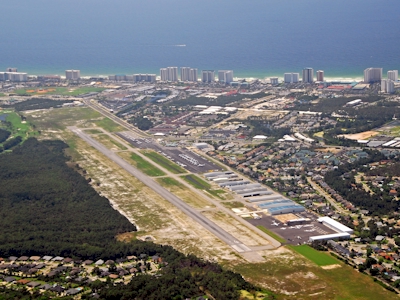
| DESTIN-FORT WALTON BEACH DESTIN FL |
| |
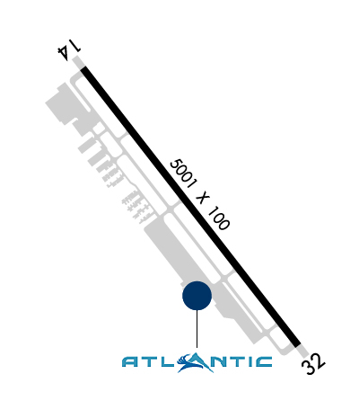
| Lat: N 3024.0 Long: W 08628.3 Elev: 23 Var: +01 Longest Runway: 5001 | ||
| Clr Del: 127.7 TW CLD Dept. ATIS: 133.92 Arr. ATIS: 133.92 AWOS: 133.92 Ground: 121.6 Tower: 118.45 | ||

| ||||||||||||||||||||||||||||||||||||||||||||||||||||||||||||||||||||
| ||||||||||||||||||||||||||||||||||||||||||||||||||||||||||||||||||||
| ||||||||||||||||||||||||||||||||||||||||||||||||||||||||||||||||||||
| Rwy | Rwy | |||||||
| 5001x100 | 5001' | 5001x100 | 5001' | |||||
| Runway ID | Single Wheel | Double Wheel | Double Tandem Wheel | Dual Double Wheel |
| 14/32 | 38,000 | 67,000 | 113,000 | N/A |
| These numbers are Advisory and are not limits. The Airport Manager should have more accurate Weight Limits | ||||
 Airport Diagram might not be current. | |
| Facility Name: | DESTIN EXEC |
| City Name: | DESTIN |
| County: | OKALOOSA |
| State abbrev: | FL |
| State Name: | FLORIDA |
| Ownership: | PUBLICLY OWNED |
| Use: | OPEN TO THE PUBLIC |
| Owner's Name: | OKALOOSA CO |
| Address: | BOARD OF COMMISSIONERS, 302 N. WILSON ST. - SUITE 302 |
| CRESTVIEW, FL 32536 | |
| Owner's Phone: | 850-689-5000 |
| Manager's Name: | TRACY STAGE |
| Address: | 1701 STATE ROAD 85 NORTH |
| EGLIN AFB, FL 32542-1413 | |
| Phone: | 850-651-7160; EXT 4 |
| FAA Region: | SOUTHERN |
| FAA Field Office: | ORL |
| Date | Sunrise | Sunset |
|---|---|---|
| 11/30/25 Sunday | 6:24 | 16:45 |
| 12/01/25 Monday | 6:25 | 16:45 |
| 12/02/25 Tuesday | 6:26 | 16:45 |
| 12/03/25 Wednesday | 6:26 | 16:45 |
| 12/04/25 Thursday | 6:27 | 16:45 |
| 12/05/25 Friday | 6:28 | 16:45 |
| 12/06/25 Saturday | 6:29 | 16:45 |
| 12/07/25 Sunday | 6:30 | 16:45 |
| 12/08/25 Monday | 6:30 | 16:45 |
| 12/09/25 Tuesday | 6:31 | 16:45 |
| 12/10/25 Wednesday | 6:32 | 16:46 |
| 12/11/25 Thursday | 6:32 | 16:46 |
| 12/12/25 Friday | 6:33 | 16:46 |
| 12/13/25 Saturday | 6:34 | 16:46 |
| Airport Attendance Schedule | 7 Days A Week 0600-2200 |
| Airport Status | OPERATIONAL (This Status can change at any time - please check NOTAMS) |
| Airport Lighting Schedule | ACTVT PAPI RWY 14 & 32; HIRL RWY 14/32 - CTAF. |
| Airport Storage Available | Tie Downs |
| Extra Services Available | Avionics, Flight Instruction, Aircraft Rental |
| Wind Indicator | YES - (lighted) |
| Control Tower | YES |
| CTAF Frequency | 118.450 |
| Unicom Frequency | |
| Rotating Beacon Color | WG |
| Segmented Circle | Y-L |
| Landing Fee | NO |
| Airport Inspected | STATE - performed by STATE AERONAUTICAL PERSONNEL |
| Inspection Date | 03/19/2025 |
| Type of Fuel Available | Grade 100LL, JET A (freeze point -40C) |
| Airframe Repair Service | MAJOR |
| Power Plant Repair Service | MAJOR |
| Latitude | N3024.0 |
| Longitude | W08628.3 (ESTIMATED) |
| Arpt Elevation | 22ft (SURVEYED) |
| Magnetic Variation | 01W |
| 1 miles E | of DESTIN |
| Traffic Pattern Altitude | |
| Sectional Chart | NEW ORLEANS |
| Operations (Reported) | Yearly | Avg. Daily |
|---|---|---|
| General Aviation Transient | 0 | 0 |
| General Aviation Local | 0 | 0 |
| Air Taxi | 0 | 0 |
| Commerical | 0 | 0 |
| Commuter | 0 | 0 |
| Military | 0 | 0 |
| Aircraft based on Field | |
|---|---|
| General Aviation Singles | 0 |
| General Aviation Multi | 0 |
| Jet Aircraft | 0 |
| General Aviation Helicopters | 0 |
| Military Aircraft | 0 |
| Gliders | 0 |
| Ultralights | 0 |
| FSS on field | NO |
| FSS tie-in | GAINESVILLE |
| FSS Phone | 1-800-WX-BRIEF |
| Who issues Notams | DTS |
| Notam D service at airport | YES |
| ARTCC Name | JACKSONVILLE |
| Airport Certification | |
| Aircraft Rescue & Firefighting Index | None |
| Airport of Entry | No |
| Custom Landing Rights | No |
| Joint Civil/Military | No |
| Military Landing rights | YES |
| NATIONAL PLAN OF INTEGRATED AIRPORT SYSTEMS (NPIAS) |
| GRANT AGREEMENTS UNDER FAAP/ADAP/AIP |
| ASSURANCES PURSUANT TO TITLE VI, CIVIL RIGHTS ACT OF 1964 |
| EXERCISE VIGILANCE DUE TO CLOSE PROXIMITY TO EGLIN AFB LCTD 6 NM NW. |
| ALL ACFT CTC EGLIN CD ON 127.7 FOR ATC DEP INSTR PRIOR TO TKOF WHEN TWR CLSD. |
| WHEN TWR CLSD; IFR ACFT RMN ON GND & CTC DEP CTL FOR CLIMB OUT INSTR & IFR RLS. |
| ARPT COND UNMON. |
| PARASAILING & BANNER TOWING WI 5 NM. |
| CAUTION: MEN & EQUIP ON & INVOF SAFETY AREA. |
| FOR FBO SERVICES CONTACT 130.05. |
Airport Communications & Frequencies:
| |||||||||||||||||||||||||||
| Runway: 14 | Runway: 32 | ||
| Mag heading: | 143° | Mag heading: | 323° |
| Rwy Slope: | -.02% Down | Rwy Slope: | .02% Up |
| Approach: | Approach: | ||
| Pattern: | Left Traffic | Pattern: | Left Traffic |
| Markings: | NONPRECISION INSTRUMENT | Markings: | NONPRECISION INSTRUMENT |
| Marking Condition: | GOOD | Marking Condition: | GOOD |
| Arresting Dev: | Arresting Dev: | ||
| Lat & Long: | N3024.3 W08628.6 | Lat. & Long.: | N3023.7 W08628.0 |
| Elev: | 22.2 ft. MSL | Elev: | 21.0 ft. MSL |
| TCH: | 43 ft. AGL | TCH: | 42 ft. AGL |
| Visual Glide Path: | 3.00 degrees | Visual Glide Path: | 3.00 degrees |
| Displaced Threshold: | No | Displaced Threshold: | No |
| Touchdown Zone: | YES | Touchdown Zone: | YES |
| Touchdown Elev.: | 22.6 feet | Touchdown Elev.: | 21.6 feet |
| Visual Glide Slope: | 4-Light PAPI on LEFT side of Runway; RWY 14 PAPI UNA BYD 6 DEG L OF RCL. | Visual Glide Slope: | 4-Light PAPI on LEFT side of Runway; RWY 32 PAPI UNUSABLE BEYOND 7 DEGREES LEFT AND RIGHT OF CNTRLN. |
| RVR Equipment: | RVR Equipment: | ||
| RVV Equipment: | NO | RVV Equipment: | NO |
| Approach Lights: | Approach Lights: | ||
| REIL: | NO | REIL: | NO |
| Centerline Lights: | NO | Centerline Lights: | NO |
| Touchdown lights: | NO | Touchdown lights: | NO |
| Runway Category: | Runway with a Non-precision Approach having visibility minimums greater than 3/4 mile | Runway Category: | Runway with a Non-precision Approach having visibility minimums greater than 3/4 mile |
| Declared Distances: | Declared Distances: | ||
| Obstructions: | TREES | Obstructions: | BLDG |
| Marked: | NOT Marked/Lighted | Marked: | LIGHTED |
| Clearance slope: | 34:1 | Clearance slope: | 40:1 |
| Obstruction height: | 37 feet AGL | Obstruction height: | 117 feet AGL |
| Dist. from runway: | 1485 feet | Dist. from runway: | 4880 feet |
| Centerline offset: | 100 left of centerline | Centerline offset: | 325 feet right of centerline |
| Comments: | Comments: |
Thanks for using FltPlan.com
all rights reserved © 1999-2025 by Flight Plan LLC


