
| DWIGHT AERO DWIGHT IL |
| |
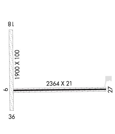
| Lat: N 4108.0 Long: W 08826.3 Elev: 632 Var: +02 Longest Runway: 2364 | ||
| CTAF: 122.8 | ||
| ||||||||||||||||||||||||||||||||||||||||||||
| ||||||||||||||||||||||||||||||||||||||||||||
| Rwy | Rwy | |||||||
| 2364x21 | 2364' | 2364x21 | 2064' | |||||
| 1900x100 | 1900' | 1900x100 | 1900' | |||||
| Runway ID | Single Wheel | Double Wheel | Double Tandem Wheel | Dual Double Wheel |
| 09/27 | N/A | N/A | N/A | N/A |
| 18/36 | N/A | N/A | N/A | N/A |
| These numbers are Advisory and are not limits. The Airport Manager should have more accurate Weight Limits | ||||
| FltPlan does not have IFR approach charts available for KDTG. |
 Airport Diagram might not be current. | |
| Facility Name: | DWIGHT |
| City Name: | DWIGHT |
| County: | GRUNDY |
| State abbrev: | IL |
| State Name: | ILLINOIS |
| Ownership: | PRIVATELY OWNED |
| Use: | OPEN TO THE PUBLIC |
| Owner's Name: | DWIGHT AERO SERVICE |
| Address: | 6034 E CAMBRIDGE AVENUE |
| SCOTTSDALE, AZ 85257 | |
| Owner's Phone: | (602) 319-3319 |
| Manager's Name: | DAN RIBORDY |
| Address: | PO BOX 214; EMAIL ADDRESS: DTGAERO@GMAIL.COM (ALL LOWER CASE) |
| DWIGHT, IL 60420 | |
| Phone: | (815) 374-4319 |
| FAA Region: | GREAT LAKES |
| FAA Field Office: | CHI |
| Date | Sunrise | Sunset |
|---|---|---|
| 07/25/26 Saturday | 5:42 | 20:17 |
| 07/26/26 Sunday | 5:43 | 20:17 |
| 07/27/26 Monday | 5:44 | 20:16 |
| 07/28/26 Tuesday | 5:45 | 20:15 |
| 07/29/26 Wednesday | 5:46 | 20:14 |
| 07/30/26 Thursday | 5:47 | 20:13 |
| 07/31/26 Friday | 5:48 | 20:12 |
| 08/01/26 Saturday | 5:49 | 20:10 |
| 08/02/26 Sunday | 5:50 | 20:09 |
| 08/03/26 Monday | 5:51 | 20:08 |
| 08/04/26 Tuesday | 5:52 | 20:07 |
| 08/05/26 Wednesday | 5:53 | 20:06 |
| 08/06/26 Thursday | 5:54 | 20:05 |
| 08/07/26 Friday | 5:55 | 20:03 |
| Airport Attendance Schedule | UNATTENDED |
| Airport Status | OPERATIONAL (This Status can change at any time - please check NOTAMS) |
| Airport Lighting Schedule | FOR LIRL RY 09/27 AFTER 2200 CALL 815-258-8218.; FOR ROTG BCN CALL 815-258-8218. |
| Airport Storage Available | Tie Downs, Hanger |
| Extra Services Available | NONE |
| Wind Indicator | YES - (unlit) |
| Control Tower | NO |
| CTAF Frequency | 122.800 |
| Unicom Frequency | 122.800 |
| Rotating Beacon Color | WG |
| Segmented Circle | NO |
| Landing Fee | NO |
| Airport Inspected | STATE - performed by STATE AERONAUTICAL PERSONNEL |
| Inspection Date | 06/26/2025 |
| Type of Fuel Available | Grade 100LL |
| Airframe Repair Service | None |
| Power Plant Repair Service | None |
| Latitude | N4108.0 |
| Longitude | W08826.3 (ESTIMATED) |
| Arpt Elevation | 632ft (ESTIMATED) |
| Magnetic Variation | 02W |
| 3 miles N | of DWIGHT |
| Traffic Pattern Altitude | 800 |
| Sectional Chart | CHICAGO |
| Operations (Reported) | Yearly | Avg. Daily |
|---|---|---|
| General Aviation Transient | 0 | 0 |
| General Aviation Local | 0 | 0 |
| Air Taxi | 0 | 0 |
| Commerical | 0 | 0 |
| Commuter | 0 | 0 |
| Military | 0 | 0 |
| Aircraft based on Field | |
|---|---|
| General Aviation Singles | 0 |
| General Aviation Multi | 0 |
| Jet Aircraft | 0 |
| General Aviation Helicopters | 0 |
| Military Aircraft | 0 |
| Gliders | 0 |
| Ultralights | 0 |
| FSS on field | NO |
| FSS tie-in | KANKAKEE |
| FSS Phone | 1-800-WX-BRIEF |
| Who issues Notams | IKK |
| Notam D service at airport | YES |
| ARTCC Name | CHICAGO |
| Airport Certification | |
| Aircraft Rescue & Firefighting Index | None |
| Airport of Entry | No |
| Custom Landing Rights | No |
| Joint Civil/Military | No |
| Military Landing rights | No |
| FOR CD CTC CHICAGO ARTCC AT 630-906-8921. |
| RWY 09/2 7 21' ASPH STRIP CENTERED ON 100' TURF STRIP. |
| RWY 09/2 7 RY 09/27 NSTD LIRL; NOT FAA APPROVED L-800 SERIES. SPACING & INTST OF LGTS VARY. |
Airport Communications & Frequencies:
| |||||||||
| Runway: 09 | Runway: 27 | ||
| Mag heading: | 90° | Mag heading: | 270° |
| Rwy Slope: | -.25% Down | Rwy Slope: | .25% Up |
| Approach: | Approach: | ||
| Pattern: | Left Traffic | Pattern: | Left Traffic |
| Markings: | NONSTANDARD | Markings: | NONSTANDARD |
| Marking Condition: | GOOD; 09/27 NSTD MKGS DUE TO NARROW WIDTH. | Marking Condition: | GOOD |
| Arresting Dev: | Arresting Dev: | ||
| Lat & Long: | N4108.0 W08826.6 | Lat. & Long.: | N4108.0 W08826.1 |
| Elev: | 629.0 ft. MSL | Elev: | 623.0 ft. MSL |
| TCH: | TCH: | ||
| Visual Glide Path: | Visual Glide Path: | ||
| Displaced Threshold: | No | Displaced Threshold: | 300 feet |
| Touchdown Zone: | YES | Touchdown Zone: | YES |
| Touchdown Elev.: | 629.0 feet | Touchdown Elev.: | 629.0 feet |
| Visual Glide Slope: | Visual Glide Slope: | ||
| RVR Equipment: | RVR Equipment: | ||
| RVV Equipment: | NO | RVV Equipment: | NO |
| Approach Lights: | Approach Lights: | ||
| REIL: | NO | REIL: | NO |
| Centerline Lights: | NO | Centerline Lights: | NO |
| Touchdown lights: | NO | Touchdown lights: | NO |
| Runway Category: | Runway with a Visual Approach | Runway Category: | Runway with a Visual Approach |
| Declared Distances: | Declared Distances: | ||
| Obstructions: | CROPS | Obstructions: | ROAD |
| Marked: | NOT Marked/Lighted | Marked: | NOT Marked/Lighted |
| Clearance slope: | CONTROLLING OBSTN EXCEEDS A 45 DEG SLP. | Clearance slope: | CONTROLLING OBSTN EXCEEDS A 45 DEG SLP. |
| Obstruction height: | 8 feet AGL | Obstruction height: | 15 feet AGL |
| Dist. from runway: | 200 feet | Dist. from runway: | 200 feet |
| Centerline offset: | Centerline offset: | 180 feet right of centerline | |
| Comments: | RWY 09, 8 FT CROP 100 FT FM END OF RWY, OB CNTRLN, 12 TO 1. | Comments: | RWY 27 15 FT RD 185 FT FM RY END 0B CNTRLN. |
| Runway: 18 | Runway: 36 | ||
| Mag heading: | N/A | Mag heading: | N/A |
| Approach: | Approach: | ||
| Pattern: | Left Traffic | Pattern: | Left Traffic |
| Markings: | NONE | Markings: | NONE |
| Marking Condition: | Marking Condition: | ||
| Arresting Dev: | Arresting Dev: | ||
| Lat & Long: | Lat. & Long.: | ||
| Elev: | N/A | Elev: | N/A |
| TCH: | TCH: | ||
| Visual Glide Path: | Visual Glide Path: | ||
| Displaced Threshold: | No | Displaced Threshold: | No |
| Touchdown Zone: | NO | Touchdown Zone: | NO |
| Touchdown Elev.: | Touchdown Elev.: | ||
| Visual Glide Slope: | Visual Glide Slope: | ||
| RVR Equipment: | RVR Equipment: | ||
| RVV Equipment: | NO | RVV Equipment: | NO |
| Approach Lights: | Approach Lights: | ||
| REIL: | NO | REIL: | NO |
| Centerline Lights: | NO | Centerline Lights: | NO |
| Touchdown lights: | NO | Touchdown lights: | NO |
| Runway Category: | Runway with a Visual Approach | Runway Category: | Runway with a Visual Approach |
| Declared Distances: | Declared Distances: | ||
| Obstructions: | CROPS | Obstructions: | CROPS |
| Marked: | NOT Marked/Lighted | Marked: | NOT Marked/Lighted |
| Clearance slope: | 6:1 | Clearance slope: | 6:1 |
| Obstruction height: | 8 feet AGL | Obstruction height: | 8 feet AGL |
| Dist. from runway: | 50 feet | Dist. from runway: | 50 feet |
| Centerline offset: | Centerline offset: | ||
| Comments: | Comments: |
Thanks for using FltPlan.com
all rights reserved © 1999-2026 by Flight Plan LLC
