
| COLUMBIA GORGE RGNL/THE DALLES THE DALLES OR |
| |
| Lat: N 4537.2 Long: W 12110.1 Elev: 247 Var: -15 Longest Runway: 5097 | ||
| AWOS: 135.17 CTAF: 123.0 | ||
| ||||||
| ||||||
|
| Rwy | Rwy | |||||||
| 4647x100 | 4207' | 4647x100 | 4451' | 109.35 - 238° | ||||
| 5097x100 | 4897' | 5097x100 | 5097' | |||||
| Runway ID | Single Wheel | Double Wheel | Double Tandem Wheel | Dual Double Wheel |
| 07/25 | 30,000 | 30,000 | N/A | N/A |
| 13/31 | 30,000 | 30,000 | N/A | N/A |
| These numbers are Advisory and are not limits. The Airport Manager should have more accurate Weight Limits | ||||
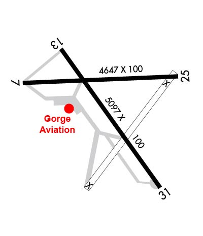 Airport Diagram might not be current. | |
| Facility Name: | COLUMBIA GORGE RGNL/THE DALLES MUNI |
| City Name: | THE DALLES |
| County: | KLICKITAT |
| State abbrev: | OR |
| State Name: | OREGON |
| Ownership: | PUBLICLY OWNED |
| Use: | OPEN TO THE PUBLIC |
| Owner's Name: | CITY OF THE DALLES/KLICKITAT COUNTY |
| Address: | PO BOX 285 |
| DALLES PORT, WA 98617 | |
| Owner's Phone: | 509-767-2272 |
| Manager's Name: | JEFF RENARD |
| Address: | PO BOX 285 |
| DALLES PORT, WA 98617 | |
| Phone: | 509-767-2272; ADNL CTC - 541-288-6766. MANAGER@FLYCGRA.COM. |
| FAA Region: | NORTHWEST MOUNTAIN |
| FAA Field Office: | SEA |
| Date | Sunrise | Sunset |
|---|---|---|
| 09/24/21 Friday | 6:54 | 18:59 |
| 09/25/21 Saturday | 6:55 | 18:57 |
| 09/26/21 Sunday | 6:56 | 18:55 |
| 09/27/21 Monday | 6:58 | 18:53 |
| 09/28/21 Tuesday | 6:59 | 18:51 |
| 09/29/21 Wednesday | 7:00 | 18:49 |
| 09/30/21 Thursday | 7:01 | 18:47 |
| 10/01/21 Friday | 7:03 | 18:45 |
| 10/02/21 Saturday | 7:04 | 18:43 |
| 10/03/21 Sunday | 7:05 | 18:41 |
| 10/04/21 Monday | 7:07 | 18:39 |
| 10/05/21 Tuesday | 7:08 | 18:38 |
| 10/06/21 Wednesday | 7:09 | 18:36 |
| 10/07/21 Thursday | 7:10 | 18:34 |
| Airport Attendance Schedule | 7 Days A Week 0800-1700 |
| Airport Status | OPERATIONAL (This Status can change at any time - please check NOTAMS) |
| Airport Lighting Schedule | ACTVT MIRL RYS 13/31 & 07/25, & REIL RY 31 - CTAF. REIL OPERATES ON 7 CLICKS ONLY. |
| Airport Storage Available | Tie Downs |
| Extra Services Available | Crop Dusting, Flight Instruction, Aircraft Rental |
| Wind Indicator | YES - (lighted) |
| Control Tower | NO |
| CTAF Frequency | 123.000 |
| Unicom Frequency | 123.000 |
| Rotating Beacon Color | CLEAR-GREEN (Light Land Airport) |
| Segmented Circle | YES |
| Landing Fee | NO |
| Airport Inspected | STATE - performed by STATE AERONAUTICAL PERSONNEL |
| Inspection Date | 01/29/2019 |
| Type of Fuel Available | Grade 100LL, JET A-1 (freeze point -50C) |
| Airframe Repair Service | MAJOR |
| Power Plant Repair Service | MAJOR |
| Latitude | N4537.2 |
| Longitude | W12110.1 (ESTIMATED) |
| Arpt Elevation | 246ft (SURVEYED) |
| Magnetic Variation | 15E |
| 2 miles NE | of THE DALLES |
| Traffic Pattern Altitude | |
| Sectional Chart | SEATTLE |
| Operations (Reported) | Yearly | Avg. Daily |
|---|---|---|
| General Aviation Transient | 8920 | 24 |
| General Aviation Local | 4710 | 13 |
| Air Taxi | 1852 | 5 |
| Commerical | 0 | 0 |
| Commuter | 0 | 0 |
| Military | 800 | 2 |
| Aircraft based on Field | |
|---|---|
| General Aviation Singles | 62 |
| General Aviation Multi | 2 |
| Jet Aircraft | 0 |
| General Aviation Helicopters | 2 |
| Military Aircraft | 0 |
| Gliders | 1 |
| Ultralights | 0 |
| FSS on field | NO |
| FSS tie-in | SEATTLE |
| FSS Phone | 1-800-WX-BRIEF |
| Who issues Notams | DLS |
| Notam D service at airport | YES |
| ARTCC Name | SEATTLE |
| Airport Certification | |
| Aircraft Rescue & Firefighting Index | None |
| Airport of Entry | No |
| Custom Landing Rights | No |
| Joint Civil/Military | No |
| Military Landing rights | YES |
| NATIONAL PLAN OF INTEGRATED AIRPORT SYSTEMS (NPIAS) |
| GRANT AGREEMENTS UNDER FAAP/ADAP/AIP |
| ASSURANCES PURSUANT TO TITLE VI, CIVIL RIGHTS ACT OF 1964 |
| AGREEMENT UNDER DLAND OR DCLA HAS EXPIRED. |
| MTNS BYD 5000' APCH RY 31. |
| ALL TWYS MARKED WITH REFLECTORS. |
| WATERFOWL ON AND INVOF ARPT. |
| PRIOR PERMISSION REQUIRED FOR OVERWEIGHT LNDGS. |
| FOR CD CTC SEATTLE ARTCC AT 253-351-3694. |
Airport Communications & Frequencies:
| |||||||||
| Runway: 07 | Runway: 25 | ||
| Mag heading: | 73° | Mag heading: | 253° |
| Rwy Slope: | .68% Up | Rwy Slope: | -.68% Down |
| Approach: | Approach: | ILS/DME | |
| Pattern: | Left Traffic | Pattern: | Left Traffic |
| Markings: | BASIC | Markings: | BASIC |
| Marking Condition: | GOOD | Marking Condition: | GOOD |
| Arresting Dev: | Arresting Dev: | ||
| Lat & Long: | N4537.2 W12110.7 | Lat. & Long.: | N4537.3 W12109.6 |
| Elev: | 211.1 ft. MSL | Elev: | 242.7 ft. MSL |
| TCH: | TCH: | ||
| Visual Glide Path: | Visual Glide Path: | ||
| Displaced Threshold: | 440 feet | Displaced Threshold: | 196 feet |
| Touchdown Zone: | YES | Touchdown Zone: | YES |
| Touchdown Elev.: | 239.5 feet | Touchdown Elev.: | 243.3 feet |
| Visual Glide Slope: | Visual Glide Slope: | ||
| RVR Equipment: | RVR Equipment: | ||
| RVV Equipment: | NO | RVV Equipment: | NO |
| Approach Lights: | Approach Lights: | ||
| REIL: | NO | REIL: | NO |
| Centerline Lights: | NO | Centerline Lights: | NO |
| Touchdown lights: | NO | Touchdown lights: | NO |
| Runway Category: | Runway with a Visual Approach | Runway Category: | Runway with a Visual Approach |
| Declared Distances: | Declared Distances: | ||
| Obstructions: | TREES | Obstructions: | |
| Marked: | NOT Marked/Lighted | Marked: | |
| Clearance slope: | 10:1; RWY 07 , SLOPE 21:1 TO DSPLCD THLD. | Clearance slope: | 50:1; THLD DSPLCD TO PROVIDE SAFETY AREA. |
| Obstruction height: | 41 feet AGL | Obstruction height: | |
| Dist. from runway: | 639 feet | Dist. from runway: | |
| Centerline offset: | Centerline offset: | ||
| Comments: | RWY 07 +15 FTROAD, 0 FT FM END, 200 FT R. | Comments: |
| Runway: 13 | Runway: 31 | ||
| Mag heading: | 130° | Mag heading: | 310° |
| Rwy Slope: | .55% Up | Rwy Slope: | -.55% Down |
| Approach: | Approach: | ||
| Pattern: | Left Traffic | Pattern: | Left Traffic |
| Markings: | BASIC | Markings: | BASIC |
| Marking Condition: | GOOD | Marking Condition: | GOOD |
| Arresting Dev: | Arresting Dev: | ||
| Lat & Long: | N4537.4 W12110.4 | Lat. & Long.: | N4536.7 W12109.7 |
| Elev: | 210.9 ft. MSL | Elev: | 238.9 ft. MSL |
| TCH: | TCH: | ||
| Visual Glide Path: | Visual Glide Path: | ||
| Displaced Threshold: | 200 feet | Displaced Threshold: | No |
| Touchdown Zone: | YES | Touchdown Zone: | YES |
| Touchdown Elev.: | 240.3 feet | Touchdown Elev.: | 242.1 feet |
| Visual Glide Slope: | Visual Glide Slope: | ||
| RVR Equipment: | RVR Equipment: | ||
| RVV Equipment: | NO | RVV Equipment: | NO |
| Approach Lights: | Approach Lights: | ||
| REIL: | NO | REIL: | YES |
| Centerline Lights: | NO | Centerline Lights: | NO |
| Touchdown lights: | NO | Touchdown lights: | NO |
| Runway Category: | Runway with a Visual Approach | Runway Category: | Runway with a Visual Approach |
| Declared Distances: | Declared Distances: | ||
| Obstructions: | TREES | Obstructions: | |
| Marked: | NOT Marked/Lighted | Marked: | |
| Clearance slope: | 20:1; RY 13 APCH SLOPE 13:1 TO DSPLCD THLD. | Clearance slope: | 50:1 |
| Obstruction height: | 29 feet AGL | Obstruction height: | |
| Dist. from runway: | 758 feet | Dist. from runway: | |
| Centerline offset: | Centerline offset: | ||
| Comments: | Comments: |
Thanks for using FltPlan.com
all rights reserved © 1999-2021 by Flight Plan LLC
