
| DELAND MUNI-SIDNEY H TAYLOR FI DELAND FL |
| |
| Lat: N 2904.0 Long: W 08117.0 Elev: 79 Var: +05 Longest Runway: 6001 | ||
| AWOS: 119.57 CTAF: 123.07 | ||
| ||||||||||||||||||||||||||||||||||||||||||||
| ||||||||||||||||||||||||||||||||||||||||||||
| ||||||||||||||||||||||||||||||||||||||||||||
| Rwy | Rwy | |||||||
| 4301x75 | 4301' | 4301x75 | 4301' | |||||
| 6001x100 | 6001' | 6001x100 | 6001' | |||||
| Runway ID | Single Wheel | Double Wheel | Double Tandem Wheel | Dual Double Wheel |
| 05/23 | N/A | 40,000 | N/A | N/A |
| 12/30 | N/A | 60,000 | N/A | N/A |
| These numbers are Advisory and are not limits. The Airport Manager should have more accurate Weight Limits | ||||
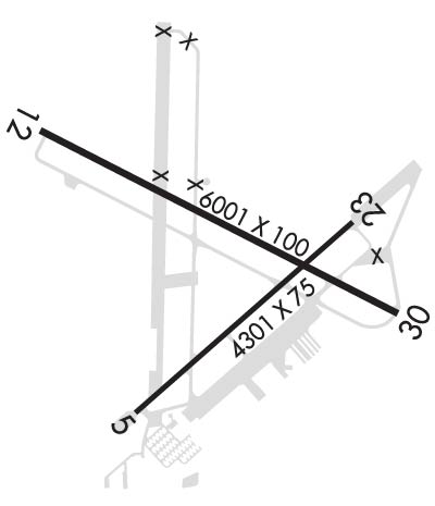 Airport Diagram might not be current. | |
| Facility Name: | DELAND MUNI-SIDNEY H TAYLOR FLD |
| City Name: | DELAND |
| County: | VOLUSIA |
| State abbrev: | FL |
| State Name: | FLORIDA |
| Ownership: | PUBLICLY OWNED |
| Use: | OPEN TO THE PUBLIC |
| Owner's Name: | CITY OF DELAND |
| Address: | 120 S FLORIDA AVE |
| DELAND, FL 32720 | |
| Owner's Phone: | 386-626-7107 |
| Manager's Name: | JOHN EIFF; ARPT PHYS ADS: 1000 FLIGHTLINE BLVD. |
| Address: | 1000 FLIGHTLINE BLVD |
| DELAND, FL 32724 | |
| Phone: | 386-626-7240 |
| FAA Region: | SOUTHERN |
| FAA Field Office: | ORL |
| Date | Sunrise | Sunset |
|---|---|---|
| 04/02/26 Thursday | 7:14 | 19:44 |
| 04/03/26 Friday | 7:13 | 19:44 |
| 04/04/26 Saturday | 7:12 | 19:45 |
| 04/05/26 Sunday | 7:11 | 19:46 |
| 04/06/26 Monday | 7:09 | 19:46 |
| 04/07/26 Tuesday | 7:08 | 19:47 |
| 04/08/26 Wednesday | 7:07 | 19:47 |
| 04/09/26 Thursday | 7:06 | 19:48 |
| 04/10/26 Friday | 7:05 | 19:48 |
| 04/11/26 Saturday | 7:04 | 19:49 |
| 04/12/26 Sunday | 7:03 | 19:50 |
| 04/13/26 Monday | 7:02 | 19:50 |
| 04/14/26 Tuesday | 7:01 | 19:51 |
| 04/15/26 Wednesday | 7:00 | 19:51 |
| Airport Attendance Schedule | MON-FRI 0800-1800, SAT-SUN 0900-1700 |
| Airport Status | OPERATIONAL (This Status can change at any time - please check NOTAMS) |
| Airport Lighting Schedule | ACTVT REIL RWY 12 & 30; PAPI RWY 30; MIRL RWY 05/23, HIRL RWY 12/30 - CTAF. PAPI RWY 05, 12, & 23 OPER CONSLY. |
| Airport Storage Available | Tie Downs, Hanger |
| Extra Services Available | Avionics, Flight Instruction, Parachute Jumping, Aircraft Rental |
| Wind Indicator | YES - (lighted) |
| Control Tower | NO |
| CTAF Frequency | 123.075 |
| Unicom Frequency | 123.075 |
| Rotating Beacon Color | WG |
| Segmented Circle | Y-L |
| Landing Fee | NO |
| Airport Inspected | STATE - performed by STATE AERONAUTICAL PERSONNEL |
| Inspection Date | 08/22/2025 |
| Type of Fuel Available | Grade 100LL, JET A (freeze point -40C)UL94; -10SELF SERVE 100LL AVBL 24 HRS WITH CREDIT CARD. |
| Airframe Repair Service | MAJOR |
| Power Plant Repair Service | MAJOR |
| Latitude | N2904.0 |
| Longitude | W08117.0 (ESTIMATED) |
| Arpt Elevation | 79ft (SURVEYED) |
| Magnetic Variation | 05W |
| 3 miles NE | of DELAND |
| Traffic Pattern Altitude | |
| Sectional Chart | JACKSONVILLE |
| Operations (Reported) | Yearly | Avg. Daily |
|---|---|---|
| General Aviation Transient | 0 | 0 |
| General Aviation Local | 0 | 0 |
| Air Taxi | 0 | 0 |
| Commerical | 0 | 0 |
| Commuter | 0 | 0 |
| Military | 0 | 0 |
| Aircraft based on Field | |
|---|---|
| General Aviation Singles | 0 |
| General Aviation Multi | 0 |
| Jet Aircraft | 0 |
| General Aviation Helicopters | 0 |
| Military Aircraft | 0 |
| Gliders | 0 |
| Ultralights | 0 |
| FSS on field | NO |
| FSS tie-in | SAINT PETERSBURG |
| FSS Phone | 1-800-WX-BRIEF |
| Who issues Notams | PIE |
| Notam D service at airport | YES |
| ARTCC Name | JACKSONVILLE |
| Airport Certification | |
| Aircraft Rescue & Firefighting Index | None |
| Airport of Entry | No |
| Custom Landing Rights | No |
| Joint Civil/Military | No |
| Military Landing rights | YES |
| NATIONAL PLAN OF INTEGRATED AIRPORT SYSTEMS (NPIAS) |
| GRANT AGREEMENTS UNDER FAAP/ADAP/AIP |
| SURPLUS PROPERTY AGREEMENT UNDER PUBLIC LAW 289 |
| SURPLUS PROPERTY AGREEMENT UNDER REGULATION 16-WAA |
| ASSURANCES PURSUANT TO TITLE VI, CIVIL RIGHTS ACT OF 1964 |
| AGREEMENT UNDER DLAND OR DCLA HAS EXPIRED. |
| UNLIGTD OBSTNS IN THE APCH TO RWY 05 DUE TO TREES 51 FT TALL 1455 FT BFR AER. |
| TOUCH & GO OPNS PROHIBITED IF THERE ARE 3 OR MORE ACFT IN THE TFC PATTERN. |
| NOISE ABATEMENT PROCEDURES IN EFFECT, CALL AMGR (386) 740-6955. |
| EXTSV PARACHUTE & FLT TRNG OPNS. AVOID OVER FLYING ARPT DURG PARACHUTE OPNS. |
| NOISE SENSITIVE ARPT. AVOID OVER FLT OF RESIDENTIAL AREA S OF ARPT; AVOID WIDE DOWNWIND RY 23. JET ACFT USE NBAA NOISE ABATEMENT PROCEDURES. |
| CALM WIND RY 05. |
| LMTD SIGHT DISTANCES ALL RYS. |
| CTC UNICOM FOR TIE DOWN INFO. |
| FOR CD OR TO CNL IFR CTC DAYTONA APCH AT 386-226-3939. |
Airport Communications & Frequencies:
| ||||||||||||||
| Runway: 05 | Runway: 23 | ||
| Mag heading: | 53° | Mag heading: | 233° |
| Rwy Slope: | -.24% Down | Rwy Slope: | .24% Up |
| Approach: | Approach: | ||
| Pattern: | Left Traffic | Pattern: | Left Traffic |
| Markings: | NONPRECISION INSTRUMENT | Markings: | NONPRECISION INSTRUMENT |
| Marking Condition: | POOR; RWY 05 MRKGS FADED & DISCOLORED. | Marking Condition: | POOR; RWY 23 MRKGS FADED & DISCOLORED. |
| Arresting Dev: | Arresting Dev: | ||
| Lat & Long: | N2903.7 W08117.3 | Lat. & Long.: | N2904.1 W08116.7 |
| Elev: | 78.3 ft. MSL | Elev: | 67.9 ft. MSL |
| TCH: | 52 ft. AGL | TCH: | 67 ft. AGL |
| Visual Glide Path: | 3.00 degrees | Visual Glide Path: | 3.00 degrees |
| Displaced Threshold: | No | Displaced Threshold: | No |
| Touchdown Zone: | YES | Touchdown Zone: | YES |
| Touchdown Elev.: | 79.2 feet | Touchdown Elev.: | 77.5 feet |
| Visual Glide Slope: | 2-Light PAPI on LEFT side of Runway | Visual Glide Slope: | 2-Light PAPI on LEFT side of Runway |
| RVR Equipment: | RVR Equipment: | ||
| RVV Equipment: | NO | RVV Equipment: | NO |
| Approach Lights: | Approach Lights: | ||
| REIL: | NO | REIL: | NO |
| Centerline Lights: | NO | Centerline Lights: | NO |
| Touchdown lights: | NO | Touchdown lights: | NO |
| Runway Category: | Runway with a Non-precision Approach having visibility minimums greater than 3/4 mile | Runway Category: | Runway with a Non-precision Approach having visibility minimums greater than 3/4 mile |
| Declared Distances: | Declared Distances: | ||
| Obstructions: | TREES | Obstructions: | TREES |
| Marked: | NOT Marked/Lighted | Marked: | NOT Marked/Lighted |
| Clearance slope: | 25:1 | Clearance slope: | 34:1 |
| Obstruction height: | 50 feet AGL | Obstruction height: | 54 feet AGL |
| Dist. from runway: | 1455 feet | Dist. from runway: | 2055 feet |
| Centerline offset: | 230 left of centerline | Centerline offset: | 200 feet left of centerline |
| Comments: | Comments: |
| Runway: 12 | Runway: 30 | ||
| Mag heading: | 122° | Mag heading: | 302° |
| Rwy Slope: | -.06% Down | Rwy Slope: | .06% Up |
| Approach: | Approach: | ||
| Pattern: | Left Traffic | Pattern: | Left Traffic |
| Markings: | NONPRECISION INSTRUMENT | Markings: | NONPRECISION INSTRUMENT |
| Marking Condition: | POOR; RWY 12 MRKGS FADED & DISCOLORED. | Marking Condition: | POOR; RWY 30 MRKGS FADED & DISCOLORED. |
| Arresting Dev: | Arresting Dev: | ||
| Lat & Long: | N2904.3 W08117.6 | Lat. & Long.: | N2903.9 W08116.6 |
| Elev: | 73.9 ft. MSL | Elev: | 70.1 ft. MSL |
| TCH: | 51 ft. AGL | TCH: | 54 ft. AGL |
| Visual Glide Path: | 3.00 degrees | Visual Glide Path: | 3.00 degrees |
| Displaced Threshold: | No | Displaced Threshold: | No |
| Touchdown Zone: | YES | Touchdown Zone: | YES |
| Touchdown Elev.: | 74.2 feet | Touchdown Elev.: | 71.4 feet |
| Visual Glide Slope: | 2-Light PAPI on LEFT side of Runway | Visual Glide Slope: | 4-Light PAPI on LEFT side of Runway |
| RVR Equipment: | RVR Equipment: | ||
| RVV Equipment: | NO | RVV Equipment: | NO |
| Approach Lights: | Approach Lights: | ||
| REIL: | YES | REIL: | YES |
| Centerline Lights: | NO | Centerline Lights: | NO |
| Touchdown lights: | NO | Touchdown lights: | NO |
| Runway Category: | Runway with a Non-precision Approach having visibility minimums greater than 3/4 mile | Runway Category: | Runway with a Non-precision Approach having visibility minimums greater than 3/4 mile |
| Declared Distances: | Declared Distances: | ||
| Obstructions: | TREES | Obstructions: | TREES |
| Marked: | NOT Marked/Lighted | Marked: | NOT Marked/Lighted |
| Clearance slope: | 34:1 | Clearance slope: | 30:1 |
| Obstruction height: | 26 feet AGL | Obstruction height: | 66 feet AGL |
| Dist. from runway: | 1105 feet | Dist. from runway: | 2220 feet |
| Centerline offset: | 75 left of centerline | Centerline offset: | 235 feet right of centerline |
| Comments: | Comments: |
Thanks for using FltPlan.com
all rights reserved © 1999-2026 by Flight Plan LLC
