
| COLUMBUS METROPOLITAN COLUMBUS GA |
| |
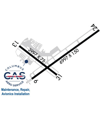
| Lat: N 3231.0 Long: W 08456.3 Elev: 397 Var: +02 Longest Runway: 6997 | ||
| Dept. ATIS: 127.75 Arr. ATIS: 127.75 Ground: 121.9 Tower: 120.1 | ||
| |||||||||||||||||||||||||||||||
| |||||||||||||||||||||||||||||||
| |||||||||||||||||||||||||||||||
| Rwy | Rwy | |||||||
| 6997x150 | 6997' | 110.30 - 055° | 6997x150 | 6997' | ||||
| 3997x75 | 3997' | 3997x75 | 3997' | |||||
| Runway ID | Single Wheel | Double Wheel | Double Tandem Wheel | Dual Double Wheel |
| 06/24 | N/A | 160,000 | 250,000 | N/A |
| 13/31 | 12,000 | N/A | N/A | N/A |
| These numbers are Advisory and are not limits. The Airport Manager should have more accurate Weight Limits | ||||
 Airport Diagram might not be current. | |
| Facility Name: | COLUMBUS |
| City Name: | COLUMBUS |
| County: | MUSCOGEE |
| State abbrev: | GA |
| State Name: | GEORGIA |
| Ownership: | PUBLICLY OWNED |
| Use: | OPEN TO THE PUBLIC |
| Owner's Name: | COLUMBUS AIRPORT COMMISSION |
| Address: | 3250 W BRITT DAVID RD |
| COLUMBUS, GA 31909 | |
| Owner's Phone: | 706-324-2449 |
| Manager's Name: | AMBER CLARK, C.M. |
| Address: | 3250 W BRITT DAVID RD |
| COLUMBUS, GA 31909 | |
| Phone: | 706-324-2449 |
| FAA Region: | SOUTHERN |
| FAA Field Office: | ATL |

| Date | Sunrise | Sunset |
|---|---|---|
| 09/24/21 Friday | 7:29 | 19:34 |
| 09/25/21 Saturday | 7:30 | 19:33 |
| 09/26/21 Sunday | 7:30 | 19:31 |
| 09/27/21 Monday | 7:31 | 19:30 |
| 09/28/21 Tuesday | 7:32 | 19:29 |
| 09/29/21 Wednesday | 7:32 | 19:27 |
| 09/30/21 Thursday | 7:33 | 19:26 |
| 10/01/21 Friday | 7:34 | 19:25 |
| 10/02/21 Saturday | 7:34 | 19:23 |
| 10/03/21 Sunday | 7:35 | 19:22 |
| 10/04/21 Monday | 7:36 | 19:21 |
| 10/05/21 Tuesday | 7:36 | 19:20 |
| 10/06/21 Wednesday | 7:37 | 19:18 |
| 10/07/21 Thursday | 7:38 | 19:17 |
| Airport Attendance Schedule | CONTINUOUS |
| Airport Status | OPERATIONAL (This Status can change at any time - please check NOTAMS) |
| Airport Lighting Schedule | 0900-2100 AFTER 2100, ACTVT HIRL RY 06/24, MIRL RY 13/31, MALSR RY 06, REIL RY 24, PAPI RY 06/24, TWY LGTS & WINDCONE LGTS - CTAF. |
| Airport Storage Available | Tie Downs, Hanger |
| Extra Services Available | Air Freight, Cargo Handling, Charter, Flight Instruction, Aircraft Rental |
| Wind Indicator | YES - (lighted) |
| Control Tower | YES |
| CTAF Frequency | 120.100 |
| Unicom Frequency | 122.950 |
| Rotating Beacon Color | CLEAR-GREEN (Light Land Airport) |
| Segmented Circle | NO |
| Landing Fee | NO |
| Airport Inspected | FEDERAL - performed by FAA AIRPORTS FIELD PERSONNEL |
| Inspection Date | 01/24/2020 |
| Type of Fuel Available | Grade 100LL, JET A (freeze point -40C); -10SELF SERVE 100LL AVBL 24 HRS. |
| Airframe Repair Service | MAJOR |
| Power Plant Repair Service | MAJOR |
| Latitude | N3231.0 |
| Longitude | W08456.3 (ESTIMATED) |
| Arpt Elevation | 397ft (SURVEYED) |
| Magnetic Variation | 02W |
| 3 miles NE | of COLUMBUS |
| Traffic Pattern Altitude | |
| Sectional Chart | ATLANTA |
| Operations (Reported) | Yearly | Avg. Daily |
|---|---|---|
| General Aviation Transient | 15885 | 44 |
| General Aviation Local | 17145 | 47 |
| Air Taxi | 2846 | 8 |
| Commerical | 348 | 1 |
| Commuter | 0 | 0 |
| Military | 536 | 1 |
| Aircraft based on Field | |
|---|---|
| General Aviation Singles | 95 |
| General Aviation Multi | 11 |
| Jet Aircraft | 9 |
| General Aviation Helicopters | 1 |
| Military Aircraft | 0 |
| Gliders | 1 |
| Ultralights | 2 |
| FSS on field | NO |
| FSS tie-in | MACON |
| FSS Phone | 1-800-WX-BRIEF |
| Who issues Notams | CSG |
| Notam D service at airport | YES |
| ARTCC Name | ATLANTA |
| Airport Certification | AIRPORT RECEIVING SCHEDULED AIR CARRIER SERVICE FROM CARRIERS CERTIFICATED BY THE CIVIL AERONAUTICS BOARD; INDEX B AIRCRAFT RESCUE AND FIREFIGHTING EQUIPMENT AVAILABLE. |
| Aircraft Rescue & Firefighting Index | AIRPORT HAS A CERTIFICATE UNDER CFR PART 139 |
| Airport of Entry | No |
| Custom Landing Rights | No |
| Joint Civil/Military | No |
| Military Landing rights | YES |
| NATIONAL PLAN OF INTEGRATED AIRPORT SYSTEMS (NPIAS) |
| GRANT AGREEMENTS UNDER FAAP/ADAP/AIP |
| ASSURANCES PURSUANT TO TITLE VI, CIVIL RIGHTS ACT OF 1964 |
| AGREEMENT UNDER DLAND OR DCLA HAS EXPIRED. |
| THIS AIRPORT HAS BEEN SURVEYED BY THE NATIONAL GEODETIC SURVEY. |
| BIRDS ON & INVOF ARPT. |
| FOR CD IF UNA TO CTC ON FSS FREQ, CTC ATLANTA APCH AT 678-364-6132, WHEN ATCT CLSD CTC ATLANTA ARTCC AT 770-210-7692. |
| BE ALERT FOR RWY 6 AT TWY D INT DEP INSTRUCTIONS WITH RWY RMNG 5085 FT TORA/TODA/ASDA. |
| BE ALERT FOR RWY 6 AT TWY F INT DEP INSTRUCTIONS WITH RWY RMNG 5623 FT TORA/TODA/ASDA. |
| RWY 13/3 1 RWY 13/31 NOT AVBL FOR SKED ACR OPNS WITH MORE THAN 9 PSGR SEATS OR UNSKED ACR AT LEAST 31 PSGR SEATS. |
Airport Communications & Frequencies:
| |||||||||||||||||||||||||||||||||||||||
| Runway: 06 | Runway: 24 | ||
| Mag heading: | 56° | Mag heading: | 236° |
| Rwy Slope: | .22% Up | Rwy Slope: | -.22% Down |
| Approach: | ILS | Approach: | |
| Pattern: | Left Traffic | Pattern: | Left Traffic |
| Markings: | PRECISION INSTRUMENT | Markings: | PRECISION INSTRUMENT |
| Marking Condition: | GOOD | Marking Condition: | GOOD |
| Arresting Dev: | Arresting Dev: | ||
| Lat & Long: | N3230.7 W08456.7 | Lat. & Long.: | N3231.4 W08455.6 |
| Elev: | 375.8 ft. MSL | Elev: | 391.0 ft. MSL |
| TCH: | 48 ft. AGL | TCH: | 64 ft. AGL |
| Visual Glide Path: | 2.61 degrees | Visual Glide Path: | 3.00 degrees |
| Displaced Threshold: | No | Displaced Threshold: | No |
| Touchdown Zone: | YES | Touchdown Zone: | YES |
| Touchdown Elev.: | 379.8 feet | Touchdown Elev.: | 391.0 feet |
| Visual Glide Slope: | 4-Light PAPI on LEFT side of Runway | Visual Glide Slope: | 4-Light PAPI on LEFT side of Runway |
| RVR Equipment: | TOUCHDOWN | RVR Equipment: | ROLLOUT |
| RVV Equipment: | NO | RVV Equipment: | NO |
| Approach Lights: | MALSR - 1,400 foot medium intensity approach lighting system with runway alignment indicator lights | Approach Lights: | |
| REIL: | NO | REIL: | YES |
| Centerline Lights: | NO | Centerline Lights: | NO |
| Touchdown lights: | NO | Touchdown lights: | NO |
| Runway Category: | Precision Instrument Runway | Runway Category: | Runway with a Non-precision Approach having visibility minimums greater than 3/4 mile |
| Declared Distances: | TORA:6997' TODA:6997' ASDA:6997' LDA:6997' | Declared Distances: | TORA:6997' TODA:6997' ASDA:6997' LDA:6997' |
| Obstructions: | TREES | Obstructions: | BLDG |
| Marked: | NOT Marked/Lighted | Marked: | LIGHTED |
| Clearance slope: | 28:1 | Clearance slope: | 16:1 |
| Obstruction height: | 79 feet AGL | Obstruction height: | 29 feet AGL |
| Dist. from runway: | 2450 feet | Dist. from runway: | 690 feet |
| Centerline offset: | 250 left of centerline | Centerline offset: | 275 feet right of centerline |
| Comments: | Comments: | +5 FT GND 200 FT FROM RY END 500 FT RIGHT. |
| Runway: 13 | Runway: 31 | ||
| Mag heading: | 129° | Mag heading: | 309° |
| Rwy Slope: | -.71% Down | Rwy Slope: | .71% Up |
| Approach: | Approach: | ||
| Pattern: | Left Traffic | Pattern: | Left Traffic |
| Markings: | NONPRECISION INSTRUMENT | Markings: | BASIC |
| Marking Condition: | GOOD | Marking Condition: | GOOD |
| Arresting Dev: | Arresting Dev: | ||
| Lat & Long: | N3231.1 W08456.9 | Lat. & Long.: | N3230.7 W08456.3 |
| Elev: | 397.4 ft. MSL | Elev: | 369.1 ft. MSL |
| TCH: | 36 ft. AGL | TCH: | 60 ft. AGL |
| Visual Glide Path: | 3.00 degrees | Visual Glide Path: | 3.00 degrees |
| Displaced Threshold: | No | Displaced Threshold: | No |
| Touchdown Zone: | YES | Touchdown Zone: | YES |
| Touchdown Elev.: | 397.4 feet | Touchdown Elev.: | 394.7 feet |
| Visual Glide Slope: | 4-Light PAPI on LEFT side of Runway | Visual Glide Slope: | 2-Box VASI on LEFT side of Runway |
| RVR Equipment: | RVR Equipment: | ||
| RVV Equipment: | NO | RVV Equipment: | NO |
| Approach Lights: | Approach Lights: | ||
| REIL: | YES | REIL: | YES |
| Centerline Lights: | NO | Centerline Lights: | NO |
| Touchdown lights: | NO | Touchdown lights: | NO |
| Runway Category: | Runway with a Non-precision Approach | Runway Category: | Runway with a Visual Approach |
| Declared Distances: | TORA:3997' TODA:3997' ASDA:3997' LDA:3997' | Declared Distances: | TORA:3997' TODA:3997' ASDA:3997' LDA:3997' |
| Obstructions: | TREE | Obstructions: | POLE |
| Marked: | NOT Marked/Lighted | Marked: | LIGHTED |
| Clearance slope: | 15:1 | Clearance slope: | 10:1 |
| Obstruction height: | 72 feet AGL | Obstruction height: | 10 feet AGL |
| Dist. from runway: | 1300 feet | Dist. from runway: | 300 feet |
| Centerline offset: | 250 left of centerline | Centerline offset: | 50 feet left of centerline |
| Comments: | Comments: |
Thanks for using FltPlan.com
all rights reserved © 1999-2021 by Flight Plan LLC


