
| CORPUS CHRISTI INTL CORPUS CHRISTI TX |
| |
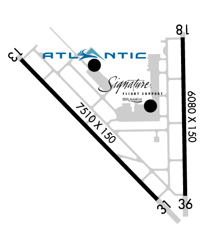
| Lat: N 2746.3 Long: W 09730.1 Elev: 46 Var: -04 Longest Runway: 7510 | ||
| Clr Del: 118.55 Dept. ATIS: 126.8 Arr. ATIS: 126.8 Ground: 121.9 Tower: 119.4 | ||
| ||||||||||||||||||||||||||||||||||||||||||||||||||||||||||||||||||||
| ||||||||||||||||||||||||||||||||||||||||||||||||||||||||||||||||||||
| ||||||||||||||||||||||||||||||||||||||||||||||||||||||||||||||||||||
| ||||||||||||||||||||||||||||||||||||||||||||||||||||||||||||||||||||
| Rwy | Rwy | |||||||
| 7510x150 | 7510' | 110.30 - 131° | 7510x150 | 7510' | 110.30 - 311° | |||
| 6080x150 | 6080' | 6080x150 | 6080' | 109.50 - 355° | ||||
| Runway ID | Single Wheel | Double Wheel | Double Tandem Wheel | Dual Double Wheel |
| 13/31 | 150,000 | 170,000 | 245,000 | N/A |
| 18/36 | 150,000 | 170,000 | 245,000 | N/A |
| These numbers are Advisory and are not limits. The Airport Manager should have more accurate Weight Limits | ||||
 Airport Diagram might not be current. | |
| Facility Name: | CORPUS CHRISTI INTL |
| City Name: | CORPUS CHRISTI |
| County: | NUECES |
| State abbrev: | TX |
| State Name: | TEXAS |
| Ownership: | PUBLICLY OWNED |
| Use: | OPEN TO THE PUBLIC |
| Owner's Name: | CITY OF CORPUS CHRISTI |
| Address: | 1201 LEOPARD ST |
| CORPUS CHRISTI, TX 78401-2825 | |
| Owner's Phone: | 361-880-3220 |
| Manager's Name: | KEVIN SMITH |
| Address: | 1000 INTERNATIONAL DR |
| CORPUS CHRISTI, TX 78406 | |
| Phone: | 361-289-0171 |
| FAA Region: | SOUTHWEST |
| FAA Field Office: | TEX |
| Date | Sunrise | Sunset |
|---|---|---|
| 05/09/26 Saturday | 6:45 | 20:09 |
| 05/10/26 Sunday | 6:44 | 20:09 |
| 05/11/26 Monday | 6:43 | 20:10 |
| 05/12/26 Tuesday | 6:43 | 20:10 |
| 05/13/26 Wednesday | 6:42 | 20:11 |
| 05/14/26 Thursday | 6:41 | 20:12 |
| 05/15/26 Friday | 6:41 | 20:12 |
| 05/16/26 Saturday | 6:40 | 20:13 |
| 05/17/26 Sunday | 6:40 | 20:13 |
| 05/18/26 Monday | 6:39 | 20:14 |
| 05/19/26 Tuesday | 6:39 | 20:14 |
| 05/20/26 Wednesday | 6:38 | 20:15 |
| 05/21/26 Thursday | 6:38 | 20:16 |
| 05/22/26 Friday | 6:37 | 20:16 |
| Airport Attendance Schedule | CONTINUOUS |
| Airport Status | OPERATIONAL (This Status can change at any time - please check NOTAMS) |
| Airport Lighting Schedule | SS-SR |
| Airport Storage Available | Tie Downs, Hanger |
| Extra Services Available | Air Freight, Avionics, Cargo Handling, Charter, Flight Instruction, Aircraft Rental, Aircraft Sales |
| Wind Indicator | YES - (lighted) |
| Control Tower | YES |
| CTAF Frequency | |
| Unicom Frequency | 122.950 |
| Rotating Beacon Color | WG |
| Segmented Circle | YES |
| Landing Fee | NO |
| Airport Inspected | FEDERAL - performed by FAA AIRPORTS FIELD PERSONNEL |
| Inspection Date | 04/24/2025 |
| Type of Fuel Available | Grade 100LL, JET A (freeze point -40C) |
| Airframe Repair Service | MAJOR |
| Power Plant Repair Service | MAJOR |
| Latitude | N2746.3 |
| Longitude | W09730.1 (ESTIMATED) |
| Arpt Elevation | 46ft (SURVEYED) |
| Magnetic Variation | 04E |
| 5 miles W | of CORPUS CHRISTI |
| Traffic Pattern Altitude | |
| Sectional Chart | BROWNSVILLE |
| Operations (Reported) | Yearly | Avg. Daily |
|---|---|---|
| General Aviation Transient | 0 | 0 |
| General Aviation Local | 0 | 0 |
| Air Taxi | 0 | 0 |
| Commerical | 0 | 0 |
| Commuter | 0 | 0 |
| Military | 0 | 0 |
| Aircraft based on Field | |
|---|---|
| General Aviation Singles | 0 |
| General Aviation Multi | 0 |
| Jet Aircraft | 0 |
| General Aviation Helicopters | 0 |
| Military Aircraft | 0 |
| Gliders | 0 |
| Ultralights | 0 |
| FSS on field | NO |
| FSS tie-in | SAN ANGELO |
| FSS Phone | 1-800-WX-BRIEF |
| Who issues Notams | CRP |
| Notam D service at airport | YES |
| ARTCC Name | HOUSTON |
| Airport Certification | AIRPORT RECEIVING SCHEDULED AIR CARRIER SERVICE FROM CARRIERS CERTIFICATED BY THE CIVIL AERONAUTICS BOARD |
| Aircraft Rescue & Firefighting Index | AIRPORT HAS A CERTIFICATE UNDER CFR PART 139 |
| Airport of Entry | No |
| Custom Landing Rights | YES |
| Joint Civil/Military | No |
| Military Landing rights | YES |
| NATIONAL PLAN OF INTEGRATED AIRPORT SYSTEMS (NPIAS) |
| GRANT AGREEMENTS UNDER FAAP/ADAP/AIP |
| ASSURANCES PURSUANT TO TITLE VI, CIVIL RIGHTS ACT OF 1964 |
| CABANISS FIELD LCTD 5 MILES SE OF ARPT MAY BE MISTAKEN FOR CORPUS CHRISTI INTL ARPT. VFR TFC MAY BE OPERATING IN THE CABANISS FIELD TFC PATTERN. |
| BIRDS ON & INVOF ARPT YEAR ROUND. |
| CUDDIHY FIELD (CLSD ARPT) IS LCTD 4 MILES SOUTH OF ARPT MAY BE MISTAKEN FOR CORPUS CHRISTI INTL ARPT. |
| ACFT AT TRML GATES ADZ GND CTL PRIOR TO PUSH. |
| UNMANNED ACFT MAY BE OPRG 3 MI WEST OF ARPT DRG DALGT HRS AT OR BLW 400 FT AGL. |
| CG - OFFL BUS, MIN 24 HR PPR. CTC CORPUS CHRISTI AIR 345.0 15 MIN PRIOR TO ENTERING CG RAMP. NO TRAN QRTS OR GOVT TRANSPORTATION AVBL. IF DESTN CG, INCL CGAS CORPUS CHRISTI IN |
| RWY 13/3 1 PCR VALUE: 507/F/D/X/U |
| RWY 18/3 6 PCR VALUE: 507/F/D/X/U |
Airport Communications & Frequencies:
| |||||||||||||||||||||||||||||||||||||||||||||||||||||||||||||||||||||||||||||||||||||
| Runway: 13 | Runway: 31 | ||
| Mag heading: | 132° | Mag heading: | 312° |
| Rwy Slope: | -.06% Down | Rwy Slope: | .06% Up |
| Approach: | ILS/DME | Approach: | LOC/DME |
| Pattern: | Right Traffic | Pattern: | Left Traffic |
| Markings: | PRECISION INSTRUMENT | Markings: | PRECISION INSTRUMENT |
| Marking Condition: | GOOD | Marking Condition: | GOOD |
| Arresting Dev: | Arresting Dev: | ||
| Lat & Long: | N2746.7 W09730.9 | Lat. & Long.: | N2745.8 W09730.0 |
| Elev: | 46.1 ft. MSL | Elev: | 41.6 ft. MSL |
| TCH: | 50 ft. AGL | TCH: | 50 ft. AGL |
| Visual Glide Path: | 3.00 degrees | Visual Glide Path: | 3.00 degrees |
| Displaced Threshold: | No | Displaced Threshold: | No |
| Touchdown Zone: | YES | Touchdown Zone: | YES |
| Touchdown Elev.: | 46.2 feet | Touchdown Elev.: | 43.6 feet |
| Visual Glide Slope: | 4-Light PAPI on LEFT side of Runway | Visual Glide Slope: | 4-Light PAPI on LEFT side of Runway |
| RVR Equipment: | TOUCHDOWN | RVR Equipment: | |
| RVV Equipment: | NO | RVV Equipment: | NO |
| Approach Lights: | MALSR - 1,400 foot medium intensity approach lighting system with runway alignment indicator lights | Approach Lights: | MALSR - 1,400 foot medium intensity approach lighting system with runway alignment indicator lights |
| REIL: | NO | REIL: | NO |
| Centerline Lights: | NO | Centerline Lights: | NO |
| Touchdown lights: | NO | Touchdown lights: | NO |
| Runway Category: | Precision Instrument Runway | Runway Category: | D |
| Declared Distances: | TORA:7510' TODA:7510' ASDA:7510' LDA:7510' | Declared Distances: | TORA:7510' TODA:7510' ASDA:7510' LDA:7510' |
| Obstructions: | POLE | Obstructions: | |
| Marked: | NOT Marked/Lighted | Marked: | |
| Clearance slope: | 47:1 | Clearance slope: | 50:1 |
| Obstruction height: | 33 feet AGL | Obstruction height: | |
| Dist. from runway: | 1782 feet | Dist. from runway: | |
| Centerline offset: | 640 left of centerline | Centerline offset: | |
| Comments: | Comments: |
| Runway: 18 | Runway: 36 | ||
| Mag heading: | 175° | Mag heading: | 355° |
| Rwy Slope: | .00% | Rwy Slope: | .00% |
| Approach: | Approach: | ILS/DME | |
| Pattern: | Left Traffic | Pattern: | Right Traffic |
| Markings: | PRECISION INSTRUMENT | Markings: | PRECISION INSTRUMENT |
| Marking Condition: | GOOD | Marking Condition: | GOOD |
| Arresting Dev: | Arresting Dev: | ||
| Lat & Long: | N2746.9 W09729.8 | Lat. & Long.: | N2745.9 W09729.8 |
| Elev: | 39.5 ft. MSL | Elev: | 39.5 ft. MSL |
| TCH: | 50 ft. AGL | TCH: | |
| Visual Glide Path: | 3.00 degrees | Visual Glide Path: | |
| Displaced Threshold: | No | Displaced Threshold: | No |
| Touchdown Zone: | YES | Touchdown Zone: | YES |
| Touchdown Elev.: | 41.9 feet | Touchdown Elev.: | 39.9 feet |
| Visual Glide Slope: | 4-Light PAPI on LEFT side of Runway | Visual Glide Slope: | |
| RVR Equipment: | RVR Equipment: | TOUCHDOWN | |
| RVV Equipment: | NO | RVV Equipment: | NO |
| Approach Lights: | MALSR - 1,400 foot medium intensity approach lighting system with runway alignment indicator lights | Approach Lights: | MALSR - 1,400 foot medium intensity approach lighting system with runway alignment indicator lights |
| REIL: | NO | REIL: | NO |
| Centerline Lights: | NO | Centerline Lights: | NO |
| Touchdown lights: | NO | Touchdown lights: | NO |
| Runway Category: | Runway with a Non-precision Approach having visibility minimums greater than 3/4 mile | Runway Category: | Precision Instrument Runway |
| Declared Distances: | TORA:6080' TODA:6080' ASDA:6080' LDA:6080' | Declared Distances: | TORA:6080' TODA:6080' ASDA:6080' LDA:6080' |
| Obstructions: | POLE | Obstructions: | |
| Marked: | NOT Marked/Lighted | Marked: | |
| Clearance slope: | 40:1 | Clearance slope: | 50:1 |
| Obstruction height: | 43 feet AGL | Obstruction height: | |
| Dist. from runway: | 1930 feet | Dist. from runway: | |
| Centerline offset: | 402 right of centerline | Centerline offset: | |
| Comments: | Comments: |
Thanks for using FltPlan.com
all rights reserved © 1999-2026 by Flight Plan LLC


