
| TSTC WACO WACO TX |
| |
| Lat: N 3138.3 Long: W 09704.4 Elev: 470 Var: -04 Longest Runway: 8600 | ||
| AWOS: 134.22 Ground: 121.7 Tower: 124.0 | ||
| ||||||
| ||||||
|
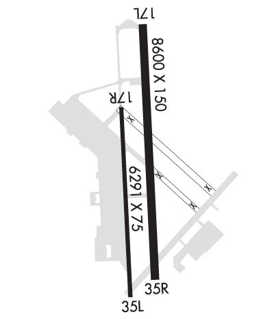
| Rwy | Rwy | |||||||
| 8600x150 | 8600' | 110.70 - 173° | 8600x150 | 8600' | ||||
| 6291x75 | 6291' | 6291x75 | 6291' | |||||
| Runway ID | Single Wheel | Double Wheel | Double Tandem Wheel | Dual Double Wheel |
| 17L/35R | 50,000 | 200,000 | 450,000 | N/A |
| 17R/35L | 25,000 | 76,000 | 140,000 | N/A |
| These numbers are Advisory and are not limits. The Airport Manager should have more accurate Weight Limits | ||||
 Airport Diagram might not be current. | |
| Facility Name: | TSTC WACO |
| City Name: | WACO |
| County: | MC LENNAN |
| State abbrev: | TX |
| State Name: | TEXAS |
| Ownership: | PUBLICLY OWNED |
| Use: | OPEN TO THE PUBLIC |
| Owner's Name: | TEXAS STATE TECH COLLEGE |
| Address: | 3801 CAMPUS DRIVE |
| WACO, TX 76705 | |
| Owner's Phone: | 254-799-3611 |
| Manager's Name: | GORDON ROWELL |
| Address: | 3801 CAMPUS DRIVE |
| WACO, TX 76705 | |
| Phone: | 254-867-2280 |
| FAA Region: | SOUTHWEST |
| FAA Field Office: | TEX |
| Date | Sunrise | Sunset |
|---|---|---|
| 04/03/26 Friday | 7:15 | 19:49 |
| 04/04/26 Saturday | 7:13 | 19:50 |
| 04/05/26 Sunday | 7:12 | 19:50 |
| 04/06/26 Monday | 7:11 | 19:51 |
| 04/07/26 Tuesday | 7:10 | 19:52 |
| 04/08/26 Wednesday | 7:08 | 19:52 |
| 04/09/26 Thursday | 7:07 | 19:53 |
| 04/10/26 Friday | 7:06 | 19:54 |
| 04/11/26 Saturday | 7:05 | 19:54 |
| 04/12/26 Sunday | 7:04 | 19:55 |
| 04/13/26 Monday | 7:02 | 19:56 |
| 04/14/26 Tuesday | 7:01 | 19:56 |
| 04/15/26 Wednesday | 7:00 | 19:57 |
| 04/16/26 Thursday | 6:59 | 19:58 |
| Airport Attendance Schedule | MON-FRI 0600-1800 |
| Airport Status | OPERATIONAL (This Status can change at any time - please check NOTAMS) |
| Airport Lighting Schedule | WHEN ATCT CLSD MIRL RWY 17L/35R PRESET LOW INTST; TO INCR INTST & ACTVT MALSR RWY 17L & PAPI RWY 17L & 35R - 121.7. |
| Airport Storage Available | Tie Downs |
| Extra Services Available | Air Ambulance, Flight Instruction |
| Wind Indicator | YES - (lighted) |
| Control Tower | YES |
| CTAF Frequency | 124.000 |
| Unicom Frequency | 122.950 |
| Rotating Beacon Color | WG |
| Segmented Circle | YES |
| Landing Fee | NO |
| Airport Inspected | STATE - performed by PRIVATE CONTRACT PERSONNEL |
| Inspection Date | 05/21/2025 |
| Type of Fuel Available | Grade 100LL, JET A (freeze point -40C) |
| Airframe Repair Service | MINOR |
| Power Plant Repair Service | MINOR |
| Latitude | N3138.3 |
| Longitude | W09704.4 (ESTIMATED) |
| Arpt Elevation | 470ft (SURVEYED) |
| Magnetic Variation | 04E |
| 8 miles NE | of WACO |
| Traffic Pattern Altitude | |
| Sectional Chart | SAN ANTONIO |
| Operations (Reported) | Yearly | Avg. Daily |
|---|---|---|
| General Aviation Transient | 0 | 0 |
| General Aviation Local | 0 | 0 |
| Air Taxi | 0 | 0 |
| Commerical | 0 | 0 |
| Commuter | 0 | 0 |
| Military | 0 | 0 |
| Aircraft based on Field | |
|---|---|
| General Aviation Singles | 0 |
| General Aviation Multi | 0 |
| Jet Aircraft | 0 |
| General Aviation Helicopters | 0 |
| Military Aircraft | 0 |
| Gliders | 0 |
| Ultralights | 0 |
| FSS on field | NO |
| FSS tie-in | FORT WORTH |
| FSS Phone | 1-800-WX-BRIEF |
| Who issues Notams | FTW |
| Notam D service at airport | YES |
| ARTCC Name | FORT WORTH |
| Airport Certification | |
| Aircraft Rescue & Firefighting Index | None |
| Airport of Entry | No |
| Custom Landing Rights | No |
| Joint Civil/Military | No |
| Military Landing rights | YES |
| NATIONAL PLAN OF INTEGRATED AIRPORT SYSTEMS (NPIAS) |
| GRANT AGREEMENTS UNDER FAAP/ADAP/AIP |
| ASSURANCES PURSUANT TO TITLE VI, CIVIL RIGHTS ACT OF 1964 |
| EXTSV FLT TRNG IN CLASS D AIRSPACE SFC TO 3000 FT AGL. |
| APU AVBL FOR JET ACFT. |
| RWY 17R-35L NOT LGTD. MAY BE USED FOR TAXI AND HEL OPNS. |
| AMGR CELL 910-578-8509. |
Airport Communications & Frequencies:
| |||||||||||||||||||||||
| Runway: 17L | Runway: 35R | ||
| Mag heading: | 174° | Mag heading: | 354° |
| Rwy Slope: | -.16% Down | Rwy Slope: | .16% Up |
| Approach: | ILS | Approach: | |
| Pattern: | Left Traffic | Pattern: | Right Traffic |
| Markings: | PRECISION INSTRUMENT | Markings: | PRECISION INSTRUMENT |
| Marking Condition: | GOOD | Marking Condition: | GOOD |
| Arresting Dev: | Arresting Dev: | ||
| Lat & Long: | N3139.1 W09704.4 | Lat. & Long.: | N3137.7 W09704.4 |
| Elev: | 469.8 ft. MSL | Elev: | 456.0 ft. MSL |
| TCH: | 52 ft. AGL | TCH: | 41 ft. AGL |
| Visual Glide Path: | 3.00 degrees | Visual Glide Path: | 3.00 degrees |
| Displaced Threshold: | No | Displaced Threshold: | No |
| Touchdown Zone: | YES | Touchdown Zone: | YES |
| Touchdown Elev.: | 469.9 feet | Touchdown Elev.: | 462.0 feet |
| Visual Glide Slope: | 4-Light PAPI on RIGHT side of Runway | Visual Glide Slope: | 4-Light PAPI on LEFT side of Runway |
| RVR Equipment: | RVR Equipment: | ||
| RVV Equipment: | NO | RVV Equipment: | NO |
| Approach Lights: | MALSR - 1,400 foot medium intensity approach lighting system with runway alignment indicator lights | Approach Lights: | |
| REIL: | NO | REIL: | NO |
| Centerline Lights: | NO | Centerline Lights: | NO |
| Touchdown lights: | NO | Touchdown lights: | NO |
| Runway Category: | Precision Instrument Runway | Runway Category: | Runway with a Non-precision Approach having visibility minimums greater than 3/4 mile |
| Declared Distances: | Declared Distances: | ||
| Obstructions: | TREES | Obstructions: | TREES |
| Marked: | NOT Marked/Lighted | Marked: | NOT Marked/Lighted |
| Clearance slope: | 39:1 | Clearance slope: | 34:1 |
| Obstruction height: | 44 feet AGL | Obstruction height: | 67 feet AGL |
| Dist. from runway: | 1929 feet | Dist. from runway: | 2515 feet |
| Centerline offset: | 790 right of centerline | Centerline offset: | 750 feet right of centerline |
| Comments: | Comments: |
| Runway: 17R | Runway: 35L | ||
| Mag heading: | 174° | Mag heading: | 354° |
| Rwy Slope: | -.11% Down | Rwy Slope: | .11% Up |
| Approach: | Approach: | ||
| Pattern: | Right Traffic | Pattern: | Left Traffic |
| Markings: | NONPRECISION INSTRUMENT | Markings: | NONPRECISION INSTRUMENT |
| Marking Condition: | FAIR | Marking Condition: | FAIR |
| Arresting Dev: | Arresting Dev: | ||
| Lat & Long: | N3138.6 W09704.6 | Lat. & Long.: | N3137.6 W09704.5 |
| Elev: | 466.6 ft. MSL | Elev: | 459.6 ft. MSL |
| TCH: | TCH: | ||
| Visual Glide Path: | Visual Glide Path: | ||
| Displaced Threshold: | No | Displaced Threshold: | No |
| Touchdown Zone: | YES | Touchdown Zone: | YES |
| Touchdown Elev.: | 470.2 feet | Touchdown Elev.: | 469.3 feet |
| Visual Glide Slope: | Visual Glide Slope: | ||
| RVR Equipment: | RVR Equipment: | ||
| RVV Equipment: | NO | RVV Equipment: | NO |
| Approach Lights: | Approach Lights: | ||
| REIL: | NO | REIL: | NO |
| Centerline Lights: | NO; 17R/35L GREEN CNTRLN REFLECTORS ALONG FULL LENGTH OF RWY. | Centerline Lights: | NO; GREEN CNTRLN REFLECTORS ALONG FULL LENGTH OF RWY. |
| Touchdown lights: | NO | Touchdown lights: | NO |
| Runway Category: | Runway with a Visual Approach | Runway Category: | Runway with a Visual Approach |
| Declared Distances: | Declared Distances: | ||
| Obstructions: | Obstructions: | TREES | |
| Marked: | Marked: | NOT Marked/Lighted | |
| Clearance slope: | 50:1 | Clearance slope: | 28:1 |
| Obstruction height: | Obstruction height: | 48 feet AGL | |
| Dist. from runway: | Dist. from runway: | 1560 feet | |
| Centerline offset: | Centerline offset: | 410 feet right of centerline | |
| Comments: | Comments: |
Thanks for using FltPlan.com
all rights reserved © 1999-2026 by Flight Plan LLC
