
| EASTERWOOD FIELD COLLEGE STATION TX |
| |
| Lat: N 3035.3 Long: W 09621.8 Elev: 321 Var: -03 Longest Runway: 7000 | ||
| Clr Del: 120.4 TWR CLD Dept. ATIS: 126.85 Arr. ATIS: 126.85 AWOS: 126.85 Ground: 128.7 Tower: 118.5 | ||
| ||||||||||||||||||||||||||||||||||||||||||||
| ||||||||||||||||||||||||||||||||||||||||||||
| ||||||||||||||||||||||||||||||||||||||||||||
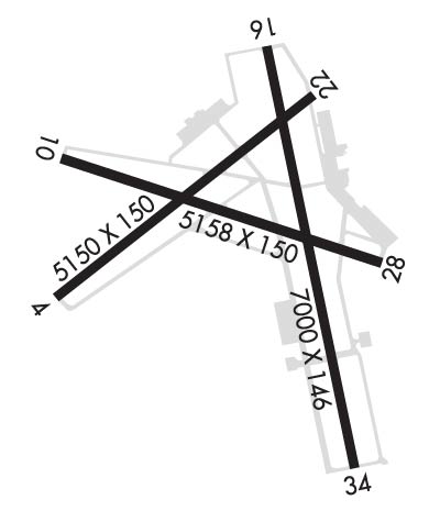
| Rwy | Rwy | |||||||
| 5158x150 | 5158' | 5158x150 | 5158' | |||||
| 7000x146 | 7000' | 7000x146 | 7000' | 110.55 - 345° | ||||
| Runway ID | Single Wheel | Double Wheel | Double Tandem Wheel | Dual Double Wheel |
| 11/29 | 37,000 | 49,000 | N/A | N/A |
| 17/35 | 78,000 | 94,000 | 156,000 | N/A |
| These numbers are Advisory and are not limits. The Airport Manager should have more accurate Weight Limits | ||||
 Airport Diagram might not be current. | |
| Facility Name: | EASTERWOOD FLD |
| City Name: | COLLEGE STATION |
| County: | BRAZOS |
| State abbrev: | TX |
| State Name: | TEXAS |
| Ownership: | PUBLICLY OWNED |
| Use: | OPEN TO THE PUBLIC |
| Owner's Name: | TEXAS A&M UNIVERSITY |
| Address: | 301 TARROW STREET |
| COLLEGE STATION, TX 77840 | |
| Owner's Phone: | (979) 775-9900 |
| Manager's Name: | KEVIN DAVIS |
| Address: | 1 MCKENZIE TERMINAL BLVD, SUITE 112 |
| COLLEGE STATION, TX 77845 | |
| Phone: | 979-775-9901 |
| FAA Region: | SOUTHWEST |
| FAA Field Office: | TEX |
| Date | Sunrise | Sunset |
|---|---|---|
| 04/24/26 Friday | 6:49 | 19:59 |
| 04/25/26 Saturday | 6:48 | 20:00 |
| 04/26/26 Sunday | 6:47 | 20:00 |
| 04/27/26 Monday | 6:46 | 20:01 |
| 04/28/26 Tuesday | 6:45 | 20:02 |
| 04/29/26 Wednesday | 6:44 | 20:02 |
| 04/30/26 Thursday | 6:43 | 20:03 |
| 05/01/26 Friday | 6:42 | 20:04 |
| 05/02/26 Saturday | 6:41 | 20:04 |
| 05/03/26 Sunday | 6:40 | 20:05 |
| 05/04/26 Monday | 6:39 | 20:06 |
| 05/05/26 Tuesday | 6:38 | 20:06 |
| 05/06/26 Wednesday | 6:38 | 20:07 |
| 05/07/26 Thursday | 6:37 | 20:08 |
| Airport Attendance Schedule | 7 Days A Week 0600-2200 |
| Airport Status | OPERATIONAL (This Status can change at any time - please check NOTAMS) |
| Airport Lighting Schedule | WHEN ATCT CLSD ACTVT MALSR RWY 35; MIRL RWY 11/29; HIRL RWY 17/35 - CTAF. REIL RWY 29 PRESET LOW INTST ONLY. |
| Airport Storage Available | Tie Downs, Hanger |
| Extra Services Available | Avionics, Charter, Flight Instruction |
| Wind Indicator | YES - (lighted) |
| Control Tower | YES |
| CTAF Frequency | 118.500 |
| Unicom Frequency | 122.950 |
| Rotating Beacon Color | WG |
| Segmented Circle | NO |
| Landing Fee | NO |
| Airport Inspected | FEDERAL - performed by FAA AIRPORTS FIELD PERSONNEL |
| Inspection Date | 12/11/2025 |
| Type of Fuel Available | Grade 100LL, JET A (freeze point -40C), JET A; -10FUEL SVC 0600-2200. FOR FUEL AFT HRS PPR CALL 979-775-5255. LATE NIGHT FEE. |
| Airframe Repair Service | MAJOR |
| Power Plant Repair Service | MAJOR |
| Latitude | N3035.3 |
| Longitude | W09621.8 (ESTIMATED) |
| Arpt Elevation | 320ft (SURVEYED) |
| Magnetic Variation | 03E |
| 3 miles SW | of COLLEGE STATION |
| Traffic Pattern Altitude | |
| Sectional Chart | HOUSTON |
| Operations (Reported) | Yearly | Avg. Daily |
|---|---|---|
| General Aviation Transient | 0 | 0 |
| General Aviation Local | 0 | 0 |
| Air Taxi | 0 | 0 |
| Commerical | 0 | 0 |
| Commuter | 0 | 0 |
| Military | 0 | 0 |
| Aircraft based on Field | |
|---|---|
| General Aviation Singles | 0 |
| General Aviation Multi | 0 |
| Jet Aircraft | 0 |
| General Aviation Helicopters | 0 |
| Military Aircraft | 0 |
| Gliders | 0 |
| Ultralights | 0 |
| FSS on field | NO |
| FSS tie-in | MONTGOMERY COUNTY |
| FSS Phone | 1-800-WX-BRIEF |
| Who issues Notams | CLL |
| Notam D service at airport | YES |
| ARTCC Name | HOUSTON |
| Airport Certification | AIRPORT RECEIVING SCHEDULED AIR CARRIER SERVICE FROM CARRIERS CERTIFICATED BY THE CIVIL AERONAUTICS BOARD; CLSD TO UNSKED ACR OPNS WITH MORE THAN 30 PSGR SEATS EXCP 24 HRS PPR CALL AMGR 979-775-9920. |
| Aircraft Rescue & Firefighting Index | AIRPORT HAS A CERTIFICATE UNDER CFR PART 139 |
| Airport of Entry | No |
| Custom Landing Rights | No |
| Joint Civil/Military | No |
| Military Landing rights | YES |
| NATIONAL PLAN OF INTEGRATED AIRPORT SYSTEMS (NPIAS) |
| GRANT AGREEMENTS UNDER FAAP/ADAP/AIP |
| ASSURANCES PURSUANT TO TITLE VI, CIVIL RIGHTS ACT OF 1964 |
| AGREEMENT UNDER DLAND OR DCLA HAS EXPIRED. |
| ALL RAPID RFL MIL HEL ADZ ATC FOR RAPID RFL OPS & PROCD TO SOUTH RAMP. CTC ASTIN AVN UNICOM 122.95 FOR SVC PRIOR TO LNDG. RAPID RFL IS AVBL 0600-2200 DLY. SPL RQS CSDRD ON CASE BY CASE BASIS. |
| FOR CD IF UNA TO CTC ON FSS FREQ, CTC HOUSTON ARTCC AT 281-230-5622. |
| ALL ACFT PRKG ON SE RAMP MUST CTC ASTIN AVN FOR SVC OR TRNSP, UNICOM 122.95 OR 979-775-5255. |
| TURN FEE SKEDD FAR 135 AND ALL FAR 121 OPNS. |
| PAEW ADJ ALL RWYS AND TWYS 0600-1600. |
| SFC COND NOT RPRTD FM 1700-0500 LCA MON-FRI AND SAT-SUN. |
| (CONTACT PHONE NR) CABBOTT@EASTERWOODAIRPORT.COM |
| RWY 17/3 5 FIRST 1850 FT RWY 35 CONC. |
| RWY 11/2 9 PCR VALUE: 570/F/D/X/T |
| RWY 17/3 5 PCR VALUE: 300/R/D/W/T |
Airport Communications & Frequencies:
| ||||||||||||||||||||||||||||||||
| Runway: 11 | Runway: 29 | ||
| Mag heading: | 106° | Mag heading: | 286° |
| Rwy Slope: | -.16% Down | Rwy Slope: | .16% Up |
| Approach: | Approach: | ||
| Pattern: | Left Traffic | Pattern: | Left Traffic |
| Markings: | NONPRECISION INSTRUMENT | Markings: | NONPRECISION INSTRUMENT |
| Marking Condition: | GOOD | Marking Condition: | GOOD |
| Arresting Dev: | Arresting Dev: | ||
| Lat & Long: | N3035.5 W09622.4 | Lat. & Long.: | N3035.2 W09621.4 |
| Elev: | 319.4 ft. MSL | Elev: | 311.4 ft. MSL |
| TCH: | 50 ft. AGL | TCH: | 54 ft. AGL |
| Visual Glide Path: | 3.00 degrees | Visual Glide Path: | 3.00 degrees |
| Displaced Threshold: | No | Displaced Threshold: | No |
| Touchdown Zone: | YES | Touchdown Zone: | YES |
| Touchdown Elev.: | 319.4 feet | Touchdown Elev.: | 313.9 feet |
| Visual Glide Slope: | 4-BOX VASI ON LEFT SIDE OF RUNWAY | Visual Glide Slope: | 4-BOX VASI ON LEFT SIDE OF RUNWAY |
| RVR Equipment: | RVR Equipment: | ||
| RVV Equipment: | NO | RVV Equipment: | NO |
| Approach Lights: | Approach Lights: | ||
| REIL: | NO | REIL: | YES |
| Centerline Lights: | NO | Centerline Lights: | NO |
| Touchdown lights: | NO | Touchdown lights: | NO |
| Runway Category: | Runway with a Non-precision Approach having visibility minimums greater than 3/4 mile | Runway Category: | Runway with a Non-precision Approach having visibility minimums greater than 3/4 mile |
| Declared Distances: | TORA:5158' TODA:5158' ASDA:5158' LDA:5158' | Declared Distances: | TORA:5158' TODA:5158' ASDA:5158' LDA:5158' |
| Obstructions: | TREE | Obstructions: | TREE |
| Marked: | NOT Marked/Lighted | Marked: | NOT Marked/Lighted |
| Clearance slope: | 24:1 | Clearance slope: | 17:1 |
| Obstruction height: | 40 feet AGL | Obstruction height: | 18 feet AGL |
| Dist. from runway: | 1180 feet | Dist. from runway: | 500 feet |
| Centerline offset: | 400 right of centerline | Centerline offset: | 230 feet left of centerline |
| Comments: | Comments: |
| Runway: 17 | Runway: 35 | ||
| Mag heading: | 166° | Mag heading: | 346° |
| Rwy Slope: | -.23% Down | Rwy Slope: | .23% Up |
| Approach: | Approach: | ILS/DME | |
| Pattern: | Left Traffic | Pattern: | Left Traffic |
| Markings: | PRECISION INSTRUMENT | Markings: | PRECISION INSTRUMENT |
| Marking Condition: | GOOD | Marking Condition: | GOOD |
| Arresting Dev: | Arresting Dev: | ||
| Lat & Long: | N3035.8 W09621.8 | Lat. & Long.: | N3034.7 W09621.5 |
| Elev: | 320.6 ft. MSL | Elev: | 304.3 ft. MSL |
| TCH: | 51 ft. AGL | TCH: | |
| Visual Glide Path: | 3.00 degrees | Visual Glide Path: | |
| Displaced Threshold: | No | Displaced Threshold: | No |
| Touchdown Zone: | YES | Touchdown Zone: | YES |
| Touchdown Elev.: | 320.6 feet | Touchdown Elev.: | 310.6 feet |
| Visual Glide Slope: | 4-BOX VASI ON RIGHT SIDE OF RUNWAY | Visual Glide Slope: | |
| RVR Equipment: | RVR Equipment: | ||
| RVV Equipment: | NO | RVV Equipment: | NO |
| Approach Lights: | Approach Lights: | MALSR - 1,400 foot medium intensity approach lighting system with runway alignment indicator lights | |
| REIL: | NO | REIL: | NO |
| Centerline Lights: | NO | Centerline Lights: | NO |
| Touchdown lights: | NO | Touchdown lights: | NO |
| Runway Category: | Runway with a Non-precision Approach having visibility minimums greater than 3/4 mile | Runway Category: | Precision Instrument Runway |
| Declared Distances: | TORA:7000' TODA:7000' ASDA:7000' LDA:7000' | Declared Distances: | TORA:7000' TODA:7000' ASDA:6932' LDA:6932' |
| Obstructions: | TREE | Obstructions: | |
| Marked: | NOT Marked/Lighted | Marked: | |
| Clearance slope: | 7:1 | Clearance slope: | 50:1 |
| Obstruction height: | 42 feet AGL | Obstruction height: | |
| Dist. from runway: | 500 feet | Dist. from runway: | |
| Centerline offset: | 480 right of centerline | Centerline offset: | |
| Comments: | Comments: |
Thanks for using FltPlan.com
all rights reserved © 1999-2026 by Flight Plan LLC
