
| TUSCOLA AREA CARO MI |
| |
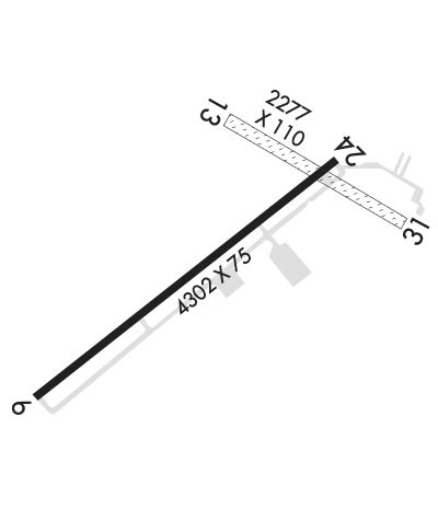
| Lat: N 4327.5 Long: W 08326.7 Elev: 704 Var: +08 Longest Runway: 4302 | ||
| AWOS: 119.27 CTAF: 123.0 | ||
| ||||||
| ||||||
|
| Rwy | Rwy | |||||||
| 4302x75 | 4302' | 4302x75 | 4302' | |||||
| 2277x110 | 2277' | 2277x110 | 1713' | |||||
| Runway ID | Single Wheel | Double Wheel | Double Tandem Wheel | Dual Double Wheel |
| 06/24 | N/A | N/A | N/A | N/A |
| 13/31 | N/A | N/A | N/A | N/A |
| These numbers are Advisory and are not limits. The Airport Manager should have more accurate Weight Limits | ||||
 Airport Diagram might not be current. | |
| Facility Name: | TUSCOLA AREA |
| City Name: | CARO |
| County: | TUSCOLA |
| State abbrev: | MI |
| State Name: | MICHIGAN |
| Ownership: | PUBLICLY OWNED |
| Use: | OPEN TO THE PUBLIC |
| Owner's Name: | TUSCOLA AREA AIRPORT AUTHORITY |
| Address: | 1750 SPEIRS RD |
| CARO, MI 48723-8211 | |
| Owner's Phone: | 989-673-4301; UNATNDD ARPT TEL. |
| Manager's Name: | JOE GREENE |
| Address: | 1750 SPEIRS RD |
| CARO, MI 48723-8211 | |
| Phone: | 989-233-4124 |
| FAA Region: | GREAT LAKES |
| FAA Field Office: | DET |
| Date | Sunrise | Sunset |
|---|---|---|
| 09/24/21 Friday | 7:23 | 19:28 |
| 09/25/21 Saturday | 7:24 | 19:26 |
| 09/26/21 Sunday | 7:25 | 19:24 |
| 09/27/21 Monday | 7:26 | 19:22 |
| 09/28/21 Tuesday | 7:27 | 19:21 |
| 09/29/21 Wednesday | 7:29 | 19:19 |
| 09/30/21 Thursday | 7:30 | 19:17 |
| 10/01/21 Friday | 7:31 | 19:15 |
| 10/02/21 Saturday | 7:32 | 19:13 |
| 10/03/21 Sunday | 7:33 | 19:12 |
| 10/04/21 Monday | 7:34 | 19:10 |
| 10/05/21 Tuesday | 7:36 | 19:08 |
| 10/06/21 Wednesday | 7:37 | 19:06 |
| 10/07/21 Thursday | 7:38 | 19:05 |
| Airport Attendance Schedule | 7 Days A Week IREG |
| Airport Status | OPERATIONAL (This Status can change at any time - please check NOTAMS) |
| Airport Lighting Schedule | ACTVT PAPI RWY 06 & 24; MIRL RWY 06/24 - CTAF. |
| Airport Storage Available | Tie Downs, Hanger |
| Extra Services Available | Flight Instruction, Aircraft Rental |
| Wind Indicator | YES - (lighted) |
| Control Tower | NO |
| CTAF Frequency | 123.000 |
| Unicom Frequency | 123.000 |
| Rotating Beacon Color | CLEAR-GREEN (Light Land Airport) |
| Segmented Circle | YES |
| Landing Fee | NO |
| Airport Inspected | STATE - performed by STATE AERONAUTICAL PERSONNEL |
| Inspection Date | 10/15/2019 |
| Type of Fuel Available | Grade 100LL, Grade 80, JET AMOGAS; -MOMOGAS AVBL WKDAYS 0800-1700 & WKENDS ON REQ. |
| Airframe Repair Service | MAJOR |
| Power Plant Repair Service | MAJOR |
| Latitude | N4327.5 |
| Longitude | W08326.7 (ESTIMATED) |
| Arpt Elevation | 704ft (SURVEYED) |
| Magnetic Variation | 08W |
| 3 miles SW | of CARO |
| Traffic Pattern Altitude | |
| Sectional Chart | DETROIT |
| Operations (Reported) | Yearly | Avg. Daily |
|---|---|---|
| General Aviation Transient | 7000 | 19 |
| General Aviation Local | 7000 | 19 |
| Air Taxi | 0 | 0 |
| Commerical | 0 | 0 |
| Commuter | 0 | 0 |
| Military | 0 | 0 |
| Aircraft based on Field | |
|---|---|
| General Aviation Singles | 33 |
| General Aviation Multi | 0 |
| Jet Aircraft | 0 |
| General Aviation Helicopters | 1 |
| Military Aircraft | 0 |
| Gliders | 0 |
| Ultralights | 0 |
| FSS on field | NO |
| FSS tie-in | LANSING |
| FSS Phone | 1-800-WX-BRIEF |
| Who issues Notams | CFS |
| Notam D service at airport | YES |
| ARTCC Name | CLEVELAND |
| Airport Certification | |
| Aircraft Rescue & Firefighting Index | None |
| Airport of Entry | No |
| Custom Landing Rights | No |
| Joint Civil/Military | No |
| Military Landing rights | YES |
| NATIONAL PLAN OF INTEGRATED AIRPORT SYSTEMS (NPIAS) |
| GRANT AGREEMENTS UNDER FAAP/ADAP/AIP |
| ASSURANCES PURSUANT TO TITLE VI, CIVIL RIGHTS ACT OF 1964 |
| DEER ON ARPT. |
| UAS OPS SOUTH OF RWY INT. |
| FOR CD CTC GREAT LAKES APCH AT 269-459-3345, WHEN APCH CLSD CTC CLEVELAND ARTCC AT 440-774-0224/0490. |
| NO SNOW REMOVAL RWY 13/31. |
Airport Communications & Frequencies:
| |||||||||||||||||
| Runway: 06 | Runway: 24 | ||
| Mag heading: | 58° | Mag heading: | 238° |
| Rwy Slope: | .36% Up | Rwy Slope: | -.36% Down |
| Approach: | Approach: | ||
| Pattern: | Left Traffic | Pattern: | Left Traffic |
| Markings: | NONPRECISION INSTRUMENT | Markings: | NONPRECISION INSTRUMENT |
| Marking Condition: | FAIR | Marking Condition: | FAIR |
| Arresting Dev: | Arresting Dev: | ||
| Lat & Long: | N4327.2 W08327.2 | Lat. & Long.: | N4327.7 W08326.5 |
| Elev: | 684.6 ft. MSL | Elev: | 700.0 ft. MSL |
| TCH: | 25 ft. AGL | TCH: | |
| Visual Glide Path: | 3.00 degrees | Visual Glide Path: | 4.00 degrees |
| Displaced Threshold: | No | Displaced Threshold: | No |
| Touchdown Zone: | YES | Touchdown Zone: | YES |
| Touchdown Elev.: | 688.6 feet | Touchdown Elev.: | 700.1 feet |
| Visual Glide Slope: | 4-Light PAPI on LEFT side of Runway | Visual Glide Slope: | 4-Light PAPI on LEFT side of Runway |
| RVR Equipment: | RVR Equipment: | ||
| RVV Equipment: | NO | RVV Equipment: | NO |
| Approach Lights: | Approach Lights: | ||
| REIL: | NO | REIL: | NO |
| Centerline Lights: | NO | Centerline Lights: | NO |
| Touchdown lights: | NO | Touchdown lights: | NO |
| Runway Category: | Runway with a Non-precision Approach | Runway Category: | Runway with a Non-precision Approach |
| Declared Distances: | Declared Distances: | ||
| Obstructions: | TREES | Obstructions: | TREE |
| Marked: | NOT Marked/Lighted | Marked: | NOT Marked/Lighted |
| Clearance slope: | 20:1 | Clearance slope: | 5:1 |
| Obstruction height: | 49 feet AGL | Obstruction height: | 26 feet AGL |
| Dist. from runway: | 1210 feet | Dist. from runway: | 355 feet |
| Centerline offset: | 280 right of centerline | Centerline offset: | 275 feet right of centerline |
| Comments: | Comments: |
| Runway: 13 | Runway: 31 | ||
| Mag heading: | 128° | Mag heading: | 308° |
| Rwy Slope: | -.67% Down | Rwy Slope: | .67% Up |
| Approach: | Approach: | ||
| Pattern: | Left Traffic | Pattern: | Left Traffic |
| Markings: | Markings: | ||
| Marking Condition: | RWY MKD WITH CONES. | Marking Condition: | RWY & DTHR MKD WITH CONES. |
| Arresting Dev: | Arresting Dev: | ||
| Lat & Long: | N4327.7 W08326.7 | Lat. & Long.: | N4327.6 W08326.3 |
| Elev: | 704.3 ft. MSL | Elev: | 689.0 ft. MSL |
| TCH: | TCH: | ||
| Visual Glide Path: | Visual Glide Path: | ||
| Displaced Threshold: | No | Displaced Threshold: | 564 feet |
| Touchdown Zone: | YES | Touchdown Zone: | YES |
| Touchdown Elev.: | 704.3 feet | Touchdown Elev.: | 704.3 feet |
| Visual Glide Slope: | Visual Glide Slope: | ||
| RVR Equipment: | RVR Equipment: | ||
| RVV Equipment: | NO | RVV Equipment: | NO |
| Approach Lights: | Approach Lights: | ||
| REIL: | NO | REIL: | NO |
| Centerline Lights: | NO | Centerline Lights: | NO |
| Touchdown lights: | NO | Touchdown lights: | NO |
| Runway Category: | Runway with a Visual Approach | Runway Category: | Runway with a Visual Approach |
| Declared Distances: | Declared Distances: | ||
| Obstructions: | TREES | Obstructions: | TREES |
| Marked: | NOT Marked/Lighted | Marked: | NOT Marked/Lighted |
| Clearance slope: | 2:1 | Clearance slope: | 9:1; APCH RATIO 20:1 AT DTHR. |
| Obstruction height: | 20 feet AGL | Obstruction height: | 70 feet AGL |
| Dist. from runway: | 55 feet | Dist. from runway: | 680 feet |
| Centerline offset: | 55 left of centerline | Centerline offset: | 125 feet left of centerline |
| Comments: | Comments: |
Thanks for using FltPlan.com
all rights reserved © 1999-2021 by Flight Plan LLC
