| CAMBRIDGE MUNI CAMBRIDGE OH |
| |
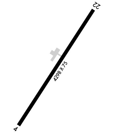
| Lat: N 3958.5 Long: W 08134.7 Elev: 799 Var: +07 Longest Runway: 4298 | ||
| AWOS: 118.52 CTAF: 123.07 | ||
| |||||||||||||||||||||||||||||||||||||||||||||||||||||||||||||||||||||
| |||||||||||||||||||||||||||||||||||||||||||||||||||||||||||||||||||||
| |||||||||||||||||||||||||||||||||||||||||||||||||||||||||||||||||||||
| Rwy | Rwy | |||||||
| 4298x75 | 3898' | 4298x75 | 4298' | 109.35 - 220° | ||||
| Runway ID | Single Wheel | Double Wheel | Double Tandem Wheel | Dual Double Wheel |
| 04/22 | 24,000 | N/A | N/A | N/A |
| These numbers are Advisory and are not limits. The Airport Manager should have more accurate Weight Limits | ||||
 Airport Diagram might not be current. | |
| Facility Name: | CAMBRIDGE MUNI |
| City Name: | CAMBRIDGE |
| County: | GUERNSEY |
| State abbrev: | OH |
| State Name: | OHIO |
| Ownership: | PUBLICLY OWNED |
| Use: | OPEN TO THE PUBLIC |
| Owner's Name: | CAMBRIDGE AREA RGNL ARPT AUTH; CDIAIRPORT@GMAIL.COM. |
| Address: | PO BOX 73 |
| CAMBRIDGE, OH 43725-0073 | |
| Owner's Phone: | 740-432-3726 |
| Manager's Name: | TERRY LOSEGO; CDIAIRPORT2@GMAIL.COM. |
| Address: | 9732 BRICK CHURCH RD |
| CAMBRIDGE, OH 43725-9420 | |
| Phone: | 740-517-0458; OPS MGR 740-517-0458, OPSMANAGER@CAMBRIDGEOHIOAIRPORT.COM. |
| FAA Region: | GREAT LAKES |
| FAA Field Office: | DET |
| Date | Sunrise | Sunset |
|---|---|---|
| 09/24/21 Friday | 7:16 | 19:21 |
| 09/25/21 Saturday | 7:16 | 19:19 |
| 09/26/21 Sunday | 7:17 | 19:17 |
| 09/27/21 Monday | 7:18 | 19:16 |
| 09/28/21 Tuesday | 7:19 | 19:14 |
| 09/29/21 Wednesday | 7:20 | 19:12 |
| 09/30/21 Thursday | 7:21 | 19:11 |
| 10/01/21 Friday | 7:22 | 19:09 |
| 10/02/21 Saturday | 7:23 | 19:07 |
| 10/03/21 Sunday | 7:24 | 19:06 |
| 10/04/21 Monday | 7:25 | 19:04 |
| 10/05/21 Tuesday | 7:26 | 19:03 |
| 10/06/21 Wednesday | 7:27 | 19:01 |
| 10/07/21 Thursday | 7:28 | 18:59 |
| Airport Attendance Schedule | MON-FRI 0800-1700, SAT-SUN UNATNDD |
| Airport Status | OPERATIONAL (This Status can change at any time - please check NOTAMS) |
| Airport Lighting Schedule | ACTVT REIL RWY 04 & 22; MIRL RWY 04/22 - CTAF. PAPI RWY 04 & 22 OPR CONSLY. |
| Airport Storage Available | Tie Downs, Hanger |
| Extra Services Available | Flight Instruction |
| Wind Indicator | YES - (lighted) |
| Control Tower | NO |
| CTAF Frequency | 123.075 |
| Unicom Frequency | 123.075 |
| Rotating Beacon Color | CLEAR-GREEN (Light Land Airport) |
| Segmented Circle | YES |
| Landing Fee | NO |
| Airport Inspected | STATE - performed by STATE AERONAUTICAL PERSONNEL |
| Inspection Date | 06/21/2019 |
| Type of Fuel Available | Grade 100LL, JET A; -10SELF SER. |
| Airframe Repair Service | NONE |
| Power Plant Repair Service | NONE |
| Latitude | N3958.5 |
| Longitude | W08134.7 (ESTIMATED) |
| Arpt Elevation | 798ft (SURVEYED) |
| Magnetic Variation | 07W |
| 3 miles S | of CAMBRIDGE |
| Traffic Pattern Altitude | |
| Sectional Chart | CINCINNATI |
| Operations (Reported) | Yearly | Avg. Daily |
|---|---|---|
| General Aviation Transient | 306 | 1 |
| General Aviation Local | 462 | 1 |
| Air Taxi | 688 | 2 |
| Commerical | 0 | 0 |
| Commuter | 0 | 0 |
| Military | 38 | 0 |
| Aircraft based on Field | |
|---|---|
| General Aviation Singles | 14 |
| General Aviation Multi | 0 |
| Jet Aircraft | 0 |
| General Aviation Helicopters | 0 |
| Military Aircraft | 0 |
| Gliders | 0 |
| Ultralights | 2 |
| FSS on field | NO |
| FSS tie-in | CLEVELAND |
| FSS Phone | 1-800-WX-BRIEF |
| Who issues Notams | CLE |
| Notam D service at airport | YES |
| ARTCC Name | CLEVELAND |
| Airport Certification | |
| Aircraft Rescue & Firefighting Index | None |
| Airport of Entry | No |
| Custom Landing Rights | No |
| Joint Civil/Military | No |
| Military Landing rights | YES |
| NATIONAL PLAN OF INTEGRATED AIRPORT SYSTEMS (NPIAS) |
| GRANT AGREEMENTS UNDER FAAP/ADAP/AIP |
| ASSURANCES PURSUANT TO TITLE VI, CIVIL RIGHTS ACT OF 1964 |
| THIS AIRPORT HAS BEEN SURVEYED BY THE NATIONAL GEODETIC SURVEY. |
| DEER, BIRDS, & OTR WILDLIFE INVOF ARPT. |
| RAMP FEES FOR COML ACFT EXC FLT TRG ACFT, CDI BASED ACFT, OVNGT HNGR STAY, FUEL PURCHASE OF 25 GALS OR TOP OFF. |
| FOR CD CTC CLEVELAND ARTCC AT 440-774-0226. |
| RWY 04 OBSTN LGTD HILLS SW OF ARPT. |
Airport Communications & Frequencies:
| |||||||||
| Runway: 04 | Runway: 22 | ||
| Mag heading: | 40° | Mag heading: | 220° |
| Rwy Slope: | .00% | Rwy Slope: | .00% |
| Approach: | Approach: | LOC/DME | |
| Pattern: | Left Traffic | Pattern: | Left Traffic |
| Markings: | NONPRECISION INSTRUMENT | Markings: | NONPRECISION INSTRUMENT |
| Marking Condition: | GOOD | Marking Condition: | GOOD |
| Arresting Dev: | Arresting Dev: | ||
| Lat & Long: | N3958.2 W08134.9 | Lat. & Long.: | N3958.8 W08134.4 |
| Elev: | 798.5 ft. MSL | Elev: | 798.5 ft. MSL |
| TCH: | 29 ft. AGL | TCH: | 28 ft. AGL |
| Visual Glide Path: | 4.00 degrees | Visual Glide Path: | 3.55 degrees |
| Displaced Threshold: | 400 feet | Displaced Threshold: | No |
| Touchdown Zone: | YES | Touchdown Zone: | YES |
| Touchdown Elev.: | 798.7 feet | Touchdown Elev.: | 798.8 feet |
| Visual Glide Slope: | 4-Light PAPI on LEFT side of Runway; UNUSBL BYD 8 DEGS R & 4 DEGS L OF CNTRLN. | Visual Glide Slope: | 4-Light PAPI on RIGHT side of Runway; UNUSBL BYD 4 DEGS R & 8 DEGS L OF CNTRLN. |
| RVR Equipment: | RVR Equipment: | ||
| RVV Equipment: | NO | RVV Equipment: | NO |
| Approach Lights: | Approach Lights: | ||
| REIL: | YES | REIL: | YES |
| Centerline Lights: | NO | Centerline Lights: | NO |
| Touchdown lights: | NO | Touchdown lights: | NO |
| Runway Category: | Runway with a Non-precision Approach | Runway Category: | Runway with a Non-precision Approach |
| Declared Distances: | Declared Distances: | ||
| Obstructions: | PLINE | Obstructions: | ROAD |
| Marked: | NOT Marked/Lighted | Marked: | NOT Marked/Lighted |
| Clearance slope: | 11:1; +50 PLINE, 1195 FT DIST, 205 FT L, 23:1 OBST CLNC SLOPE TO DTHR; +27 BLDG, 665 FT DIST, 300 FT L, 17:1 OBST CLNC SLOPE. | Clearance slope: | 10:1 |
| Obstruction height: | 50 feet AGL | Obstruction height: | 16 feet AGL |
| Dist. from runway: | 795 feet | Dist. from runway: | 355 feet |
| Centerline offset: | 205 left of centerline | Centerline offset: | 270 feet left of centerline |
| Comments: | Comments: |
Thanks for using FltPlan.com
all rights reserved © 1999-2021 by Flight Plan LLC