| COLUMBIA METROPOLITAN COLUMBIA SC |
| |
| Lat: N 3356.3 Long: W 08107.2 Elev: 236 Var: +07 Longest Runway: 8601 | ||
| Clr Del: 119.75 Dept. ATIS: 120.15 Arr. ATIS: 120.15 Ground: 121.9 Tower: 119.5 | ||
| |||||||||||||||||||||||||||||||||||||||||||||||||||||||||||||||||||
| |||||||||||||||||||||||||||||||||||||||||||||||||||||||||||||||||||
| |||||||||||||||||||||||||||||||||||||||||||||||||||||||||||||||||||
| |||||||||||||||||||||||||||||||||||||||||||||||||||||||||||||||||||
| Rwy | Rwy | |||||||
| 8001x150 | 8001' | 108.95 - 051° | 8001x150 | 7001' | ||||
| 8601x150 | 8601' | 110.30 - 111° | 8601x150 | 8601' | 108.30 - 291° | |||
| Runway ID | Single Wheel | Double Wheel | Double Tandem Wheel | Dual Double Wheel |
| 05/23 | 100,000 | 200,000 | 355,000 | 675,000 |
| 11/29 | 72,000 | 225,000 | 409,000 | 700,000 |
| H1 | N/A | N/A | N/A | N/A |
| These numbers are Advisory and are not limits. The Airport Manager should have more accurate Weight Limits | ||||
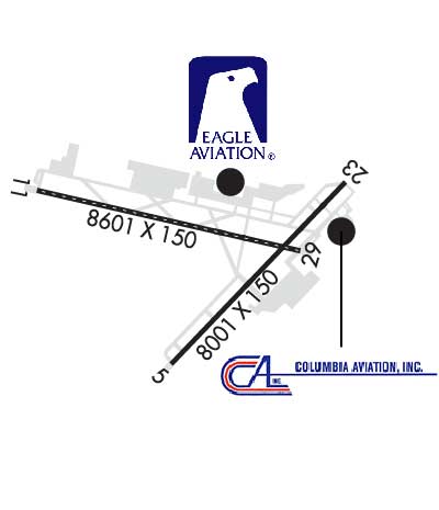 Airport Diagram might not be current. | |
| Facility Name: | COLUMBIA METRO |
| City Name: | COLUMBIA |
| County: | LEXINGTON |
| State abbrev: | SC |
| State Name: | SOUTH CAROLINA |
| Ownership: | PUBLICLY OWNED |
| Use: | OPEN TO THE PUBLIC |
| Owner's Name: | RICHLAND LEXINGTON; AIRPORT DISTRICT. |
| Address: | 3250 AIRPORT BLVD, SUITE 10 |
| WEST COLUMBIA, SC 29170 | |
| Owner's Phone: | 803-822-5050 |
| Manager's Name: | MICHEAL GULA |
| Address: | 3250 AIRPORT BLVD, SUITE 10 |
| WEST COLUMBIA, SC 29170 | |
| Phone: | (803) 822-5017 |
| FAA Region: | SOUTHERN |
| FAA Field Office: | ATL |
| Date | Sunrise | Sunset |
|---|---|---|
| 09/24/21 Friday | 7:14 | 19:19 |
| 09/25/21 Saturday | 7:14 | 19:17 |
| 09/26/21 Sunday | 7:15 | 19:16 |
| 09/27/21 Monday | 7:16 | 19:15 |
| 09/28/21 Tuesday | 7:17 | 19:13 |
| 09/29/21 Wednesday | 7:17 | 19:12 |
| 09/30/21 Thursday | 7:18 | 19:10 |
| 10/01/21 Friday | 7:19 | 19:09 |
| 10/02/21 Saturday | 7:19 | 19:08 |
| 10/03/21 Sunday | 7:20 | 19:06 |
| 10/04/21 Monday | 7:21 | 19:05 |
| 10/05/21 Tuesday | 7:22 | 19:04 |
| 10/06/21 Wednesday | 7:22 | 19:02 |
| 10/07/21 Thursday | 7:23 | 19:01 |
| Airport Attendance Schedule | CONTINUOUS |
| Airport Status | OPERATIONAL (This Status can change at any time - please check NOTAMS) |
| Airport Lighting Schedule | SS-SR |
| Airport Storage Available | Tie Downs, Hanger |
| Extra Services Available | Air Freight, Avionics, Cargo Handling, Charter, Flight Instruction, Aircraft Rental, Aircraft Sales |
| Wind Indicator | YES - (lighted) |
| Control Tower | YES |
| CTAF Frequency | |
| Unicom Frequency | 122.950 |
| Rotating Beacon Color | CLEAR-GREEN (Light Land Airport) |
| Segmented Circle | NO |
| Landing Fee | NO |
| Airport Inspected | FEDERAL - performed by FAA AIRPORTS FIELD PERSONNEL |
| Inspection Date | 04/14/2021 |
| Type of Fuel Available | Grade 100LL, JET A (freeze point -40C) |
| Airframe Repair Service | MAJOR |
| Power Plant Repair Service | MAJOR |
| Latitude | N3356.3 |
| Longitude | W08107.2 (ESTIMATED) |
| Arpt Elevation | 236ft (SURVEYED) |
| Magnetic Variation | 07W |
| 5 miles SW | of COLUMBIA |
| Traffic Pattern Altitude | |
| Sectional Chart | CHARLOTTE |
| Operations (Reported) | Yearly | Avg. Daily |
|---|---|---|
| General Aviation Transient | 14341 | 39 |
| General Aviation Local | 3297 | 9 |
| Air Taxi | 11870 | 33 |
| Commerical | 12382 | 34 |
| Commuter | 0 | 0 |
| Military | 5650 | 15 |
| Aircraft based on Field | |
|---|---|
| General Aviation Singles | 44 |
| General Aviation Multi | 13 |
| Jet Aircraft | 14 |
| General Aviation Helicopters | 5 |
| Military Aircraft | 0 |
| Gliders | 5 |
| Ultralights | 0 |
| FSS on field | NO |
| FSS tie-in | ANDERSON |
| FSS Phone | 1-800-WX-BRIEF |
| Who issues Notams | CAE |
| Notam D service at airport | YES |
| ARTCC Name | JACKSONVILLE |
| Airport Certification | AIRPORT RECEIVING SCHEDULED AIR CARRIER SERVICE FROM CARRIERS CERTIFICATED BY THE CIVIL AERONAUTICS BOARD |
| Aircraft Rescue & Firefighting Index | AIRPORT HAS A CERTIFICATE UNDER CFR PART 139 |
| Airport of Entry | No |
| Custom Landing Rights | YES |
| Joint Civil/Military | No |
| Military Landing rights | YES |
| NATIONAL PLAN OF INTEGRATED AIRPORT SYSTEMS (NPIAS) |
| GRANT AGREEMENTS UNDER FAAP/ADAP/AIP |
| SURPLUS PROPERTY AGREEMENT UNDER PUBLIC LAW 289 |
| ASSURANCES PURSUANT TO TITLE VI, CIVIL RIGHTS ACT OF 1964 |
| AGREEMENT UNDER DLAND OR DCLA HAS EXPIRED. |
| FEE FOR COMMERCIAL ACFT OVER 15000 LBS. |
| HELIPAD H1 LOCATED NORTH OF TAXILANE E, EAST OF TWY E3. |
| DUE TO PROXIMITY AND RY ALIGNMENT AIRCREWS HAVE MISTAKEN CUB (RY 13/31) FOR CAE (RY 11/29) WHICH IS 6 MILES NE. |
| OPERATION OF ULTRALIGHT VEHICLES PROHIBITED. |
| SPORTS COMPLEX WITH NUMEROUS FLOOD LGTS APRXLY 6500 FT FROM APCH END RY 11. |
| NOISE ABATEMENT PROCEDURE: NO TURNS BLO 1000 FT FOR TURBINE ENGINE ACFT UNLESS DIRECTED BY ATC. |
| ACFT LNDG WITH EXPLOSIVES OBTAIN PPR FM ARPT OPS 803-822-5050. |
| RWY 05/2 3 RY 5 200 FT BY 200 FT BLAST PAD. |
| RWY 11/2 9 RY 11 220 FT BY 400 FT BLAST PAD; RY 29 220 FT BY 400 FT BLAST PAD. |
| RWY 05/2 3 RY 05/23 CENTER 75 FT IS CONCRETE, ENTIRE LENGTH OF RY. |
Airport Communications & Frequencies:
| ||||||||||||||||||||||||||||||||||||||||||||
| Runway: 05 | Runway: 23 | ||
| Mag heading: | 52° | Mag heading: | 232° |
| Rwy Slope: | -.26% Down | Rwy Slope: | .26% Up |
| Approach: | ILS | Approach: | |
| Pattern: | Left Traffic | Pattern: | Left Traffic |
| Markings: | PRECISION INSTRUMENT | Markings: | PRECISION INSTRUMENT |
| Marking Condition: | GOOD | Marking Condition: | GOOD |
| Arresting Dev: | Arresting Dev: | ||
| Lat & Long: | N3355.7 W08107.4 | Lat. & Long.: | N3356.6 W08106.3 |
| Elev: | 227.5 ft. MSL | Elev: | 206.8 ft. MSL |
| TCH: | 73 ft. AGL | TCH: | 69 ft. AGL |
| Visual Glide Path: | 3.00 degrees | Visual Glide Path: | 3.00 degrees |
| Displaced Threshold: | No | Displaced Threshold: | 1000 feet |
| Touchdown Zone: | YES | Touchdown Zone: | YES |
| Touchdown Elev.: | 227.5 feet | Touchdown Elev.: | 212.8 feet |
| Visual Glide Slope: | 4-Light PAPI on RIGHT side of Runway | Visual Glide Slope: | 4-Light PAPI on LEFT side of Runway |
| RVR Equipment: | TOUCHDOWN | RVR Equipment: | TOUCHDOWN |
| RVV Equipment: | NO | RVV Equipment: | NO |
| Approach Lights: | MALSR - 1,400 foot medium intensity approach lighting system with runway alignment indicator lights | Approach Lights: | |
| REIL: | NO | REIL: | YES |
| Centerline Lights: | NO | Centerline Lights: | NO |
| Touchdown lights: | NO | Touchdown lights: | NO |
| Runway Category: | Precision Instrument Runway | Runway Category: | Runway with a Non-precision Approach having visibility minimums greater than 3/4 mile |
| Declared Distances: | TORA:8001' TODA:8001' ASDA:7001' LDA:7001' | Declared Distances: | TORA:8001' TODA:8001' ASDA:8001' LDA:7001' |
| Obstructions: | Obstructions: | TREE | |
| Marked: | Marked: | NOT Marked/Lighted | |
| Clearance slope: | 50:1 | Clearance slope: | 33:1 |
| Obstruction height: | Obstruction height: | 45 feet AGL | |
| Dist. from runway: | Dist. from runway: | 1575 feet | |
| Centerline offset: | Centerline offset: | 100 feet left of centerline | |
| Comments: | Comments: |
| Runway: 11 | Runway: 29 | ||
| Mag heading: | 112° | Mag heading: | 292° |
| Rwy Slope: | -.22% Down | Rwy Slope: | .22% Up |
| Approach: | ILS | Approach: | ILS |
| Pattern: | Left Traffic | Pattern: | Left Traffic |
| Markings: | PRECISION INSTRUMENT | Markings: | PRECISION INSTRUMENT |
| Marking Condition: | GOOD | Marking Condition: | GOOD |
| Arresting Dev: | Arresting Dev: | ||
| Lat & Long: | N3356.6 W08108.3 | Lat. & Long.: | N3356.3 W08106.6 |
| Elev: | 228.7 ft. MSL | Elev: | 210.0 ft. MSL |
| TCH: | 59 ft. AGL | TCH: | 57 ft. AGL |
| Visual Glide Path: | 3.00 degrees | Visual Glide Path: | 3.00 degrees |
| Displaced Threshold: | No | Displaced Threshold: | No |
| Touchdown Zone: | YES | Touchdown Zone: | YES |
| Touchdown Elev.: | 235.9 feet | Touchdown Elev.: | 227.2 feet |
| Visual Glide Slope: | 4-Light PAPI on LEFT side of Runway | Visual Glide Slope: | 4-Light PAPI on LEFT side of Runway |
| RVR Equipment: | TOUCHDOWN-MIDFIELD-ROLLOUT | RVR Equipment: | TOUCHDOWN-MIDFIELD-ROLLOUT |
| RVV Equipment: | NO | RVV Equipment: | NO |
| Approach Lights: | ALSF2 - standard 2,400 foot high intensity approach lighting system with sequenced flashers, Category II or III; ALSF2 ALSO OPERS AS SSALR. | Approach Lights: | MALSR - 1,400 foot medium intensity approach lighting system with runway alignment indicator lights |
| REIL: | NO | REIL: | NO |
| Centerline Lights: | YES | Centerline Lights: | YES |
| Touchdown lights: | YES | Touchdown lights: | NO |
| Runway Category: | Precision Instrument Runway | Runway Category: | Precision Instrument Runway |
| Declared Distances: | TORA:8601' TODA:8601' ASDA:8601' LDA:8601' | Declared Distances: | TORA:8601' TODA:8601' ASDA:8506' LDA:8506' |
Thanks for using FltPlan.com
all rights reserved © 1999-2021 by Flight Plan LLC