
| BUCKEYE MUNI BUCKEYE AZ |
| |
| Lat: N 3325.4 Long: W 11241.2 Elev: 1033 Var: -13 Longest Runway: 5500 | ||
| AWOS: 119.62 CTAF: 122.97 | ||
| |||||||||||||||||||||||||||||||||||||||||||||||||||||||||||||
| |||||||||||||||||||||||||||||||||||||||||||||||||||||||||||||
| |||||||||||||||||||||||||||||||||||||||||||||||||||||||||||||
| Rwy | Rwy | |||||||
| 5500x75 | 5500' | 5500x75 | 5500' | |||||
| Runway ID | Single Wheel | Double Wheel | Double Tandem Wheel | Dual Double Wheel |
| 17/35 | 30,000 | N/A | N/A | N/A |
| These numbers are Advisory and are not limits. The Airport Manager should have more accurate Weight Limits | ||||
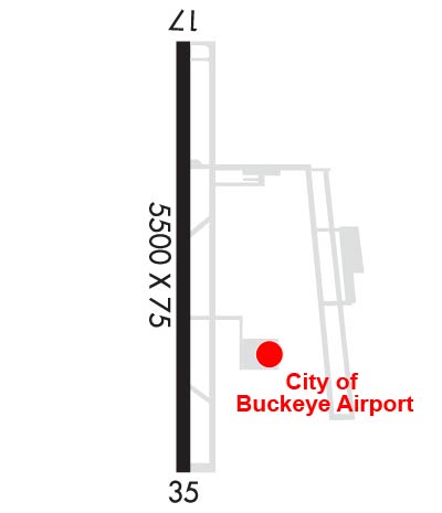 Airport Diagram might not be current. | |
| Facility Name: | BUCKEYE MUNI |
| City Name: | BUCKEYE |
| County: | MARICOPA |
| State abbrev: | AZ |
| State Name: | ARIZONA |
| Ownership: | PUBLICLY OWNED |
| Use: | OPEN TO THE PUBLIC |
| Owner's Name: | CITY OF BUCKEYE |
| Address: | 530 MONROE |
| BUCKEYE, AZ 85326 | |
| Owner's Phone: | 623-349-6650 |
| Manager's Name: | DANIEL WEIMER |
| Address: | 3000 S. PALO VERDE ROAD |
| BUCKEYE, AZ 85326 | |
| Phone: | 623-349-6880 |
| FAA Region: | WESTERN-PACIFIC |
| FAA Field Office: | PHX |

| Date | Sunrise | Sunset |
|---|---|---|
| 05/20/26 Wednesday | 5:27 | 19:28 |
| 05/21/26 Thursday | 5:27 | 19:28 |
| 05/22/26 Friday | 5:26 | 19:29 |
| 05/23/26 Saturday | 5:26 | 19:30 |
| 05/24/26 Sunday | 5:25 | 19:30 |
| 05/25/26 Monday | 5:25 | 19:31 |
| 05/26/26 Tuesday | 5:24 | 19:32 |
| 05/27/26 Wednesday | 5:24 | 19:32 |
| 05/28/26 Thursday | 5:23 | 19:33 |
| 05/29/26 Friday | 5:23 | 19:34 |
| 05/30/26 Saturday | 5:23 | 19:34 |
| 05/31/26 Sunday | 5:22 | 19:35 |
| 06/01/26 Monday | 5:22 | 19:35 |
| 06/02/26 Tuesday | 5:22 | 19:36 |
| Airport Attendance Schedule | UNATTENDED |
| Airport Status | OPERATIONAL (This Status can change at any time - please check NOTAMS) |
| Airport Lighting Schedule | ACTVT MIRL RWY 17/35 - CTAF. PAPI RWY 17 & 35 OPR CONSLY. |
| Airport Storage Available | Tie Downs |
| Extra Services Available | Glider, Parachute Jumping |
| Wind Indicator | YES - (lighted) |
| Control Tower | NO |
| CTAF Frequency | 122.975 |
| Unicom Frequency | 122.975 |
| Rotating Beacon Color | WG |
| Segmented Circle | YES |
| Landing Fee | NO |
| Airport Inspected | STATE - performed by PRIVATE CONTRACT PERSONNEL |
| Inspection Date | 04/16/2024 |
| Type of Fuel Available | Grade 100LL, JET A-1 (freeze point -50C); -10FUEL SVC AVBL H24 VIA CREDIT CARD.; -A1PPR - 623-295-9776. |
| Airframe Repair Service | MAJOR |
| Power Plant Repair Service | MAJOR |
| Latitude | N3325.4 |
| Longitude | W11241.2 (ESTIMATED) |
| Arpt Elevation | 1033ft (SURVEYED) |
| Magnetic Variation | 13E |
| 6 miles NW | of BUCKEYE |
| Traffic Pattern Altitude | 976 |
| Sectional Chart | PHOENIX |
| Operations (Reported) | Yearly | Avg. Daily |
|---|---|---|
| General Aviation Transient | 0 | 0 |
| General Aviation Local | 0 | 0 |
| Air Taxi | 0 | 0 |
| Commerical | 0 | 0 |
| Commuter | 0 | 0 |
| Military | 0 | 0 |
| Aircraft based on Field | |
|---|---|
| General Aviation Singles | 0 |
| General Aviation Multi | 0 |
| Jet Aircraft | 0 |
| General Aviation Helicopters | 0 |
| Military Aircraft | 0 |
| Gliders | 0 |
| Ultralights | 0 |
| FSS on field | NO |
| FSS tie-in | PRESCOTT |
| FSS Phone | 1-800-WX-BRIEF |
| Who issues Notams | PRC |
| Notam D service at airport | YES |
| ARTCC Name | ALBUQUERQUE |
| Airport Certification | |
| Aircraft Rescue & Firefighting Index | None |
| Airport of Entry | No |
| Custom Landing Rights | No |
| Joint Civil/Military | No |
| Military Landing rights | YES |
| NATIONAL PLAN OF INTEGRATED AIRPORT SYSTEMS (NPIAS) |
| GRANT AGREEMENTS UNDER FAAP/ADAP/AIP |
| SURPLUS PROPERTY AGREEMENT UNDER PUBLIC LAW 289 |
| ASSURANCES PURSUANT TO TITLE VI, CIVIL RIGHTS ACT OF 1964 |
| LOW LEVEL JET TFC, PAJA & WILDLIFE ON & INVOF ARPT. |
| FOR CD CTC LUKE APCH AT 623-856-7361. IF UNABLE, CTC PHOENIX APCH AT 602-306-2565. |
| PAJA DROP ZONE E OF RWY; APCH FM W; OVERFLIGHT OF ARPT OR E OF RWY NA. |
| TSNT PRKG N OF TWY C. TENANT PRKG S OF TWY C. |
| RWY 17/3 5 RWY 17 CALM WIND RWY. |
Airport Communications & Frequencies:
| ||||||||||||||||||||||||||||||||||||||
| Runway: 17 | Runway: 35 | ||
| Mag heading: | 169° | Mag heading: | 349° |
| Rwy Slope: | -.70% Down | Rwy Slope: | .70% Up |
| Approach: | Approach: | ||
| Pattern: | Right Traffic | Pattern: | Left Traffic |
| Markings: | BASIC | Markings: | BASIC |
| Marking Condition: | GOOD | Marking Condition: | GOOD |
| Arresting Dev: | Arresting Dev: | ||
| Lat & Long: | N3325.8 W11241.2 | Lat. & Long.: | N3324.9 W11241.2 |
| Elev: | 1033.0 ft. MSL | Elev: | 994.5 ft. MSL |
| TCH: | 41 ft. AGL | TCH: | 42 ft. AGL |
| Visual Glide Path: | 3.13 degrees | Visual Glide Path: | 3.00 degrees |
| Displaced Threshold: | No | Displaced Threshold: | No |
| Touchdown Zone: | YES | Touchdown Zone: | YES |
| Touchdown Elev.: | 1033.0 feet | Touchdown Elev.: | 1013.1 feet |
| Visual Glide Slope: | 2-Light PAPI on LEFT side of Runway | Visual Glide Slope: | 4-Light PAPI on LEFT side of Runway |
| RVR Equipment: | RVR Equipment: | ||
| RVV Equipment: | NO | RVV Equipment: | NO |
| Approach Lights: | Approach Lights: | ||
| REIL: | NO | REIL: | NO |
| Centerline Lights: | NO | Centerline Lights: | NO |
| Touchdown lights: | NO | Touchdown lights: | NO |
| Runway Category: | Runway with a Visual Approach | Runway Category: | Runway with a Visual Approach |
| Declared Distances: | Declared Distances: |
Thanks for using FltPlan.com
all rights reserved © 1999-2026 by Flight Plan LLC
