
| NASHVILLE INTL NASHVILLE TN |
| |
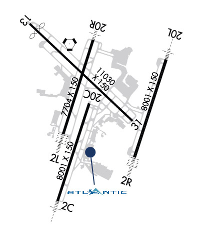
| Lat: N 3607.5 Long: W 08640.7 Elev: 599 Var: +03 Longest Runway: 11030 | ||
| Clr Del: 126.05 Dept. ATIS: 135.1 Arr. ATIS: 135.1 Ground: 121.9 Tower: 118.6 | ||

| ||||||||||||||||||||||||||||||||||||||||||||||||||||||||||||||||||||
| ||||||||||||||||||||||||||||||||||||||||||||||||||||||||||||||||||||
| ||||||||||||||||||||||||||||||||||||||||||||||||||||||||||||||||||||
| ||||||||||||||||||||||||||||||||||||||||||||||||||||||||||||||||||||
| FBOs at nearby airports who want your business: | |||||||||||||||||
| |||||||||||||||||
| Rwy | Rwy | |||||||
| 8001x150 | 8001' | 110.75 - 020° | 8001x150 | 8001' | ||||
| 7704x150 | 7704' | 109.90 - 020° | 7704x150 | 7704' | 111.30 - 200° | |||
| 8001x150 | 8001' | 111.75 - 020° | 8001x150 | 8001' | 109.35 - 200° | |||
| 11030x150 | 10230' | 11030x150 | 10289' | 111.95 - 316° | ||||
| Runway ID | Single Wheel | Double Wheel | Double Tandem Wheel | Dual Double Wheel |
| 02C/20C | 120,000 | 204,000 | 386,000 | 885,000 |
| 02L/20R | N/A | N/A | N/A | N/A |
| 02R/20L | N/A | N/A | N/A | N/A |
| 13/31 | N/A | N/A | N/A | N/A |
| These numbers are Advisory and are not limits. The Airport Manager should have more accurate Weight Limits | ||||
 Airport Diagram might not be current. | |
| Facility Name: | NASHVILLE INTL |
| City Name: | NASHVILLE |
| County: | DAVIDSON |
| State abbrev: | TN |
| State Name: | TENNESSEE |
| Ownership: | PUBLICLY OWNED |
| Use: | OPEN TO THE PUBLIC |
| Owner's Name: | METRO NASHVILLE ARPT AUTH |
| Address: | 140 BNA PARK DR. SUITE 520 |
| NASHVILLE, TN 37214 | |
| Owner's Phone: | 615-275-1600 |
| Manager's Name: | ADAM FLOYD |
| Address: | 140 BNA PARK DR. SUITE 520 |
| NASHVILLE, TN 37214 | |
| Phone: | 615-275-1546 |
| FAA Region: | SOUTHERN |
| FAA Field Office: | MEM |

| Date | Sunrise | Sunset |
|---|---|---|
| 06/02/26 Tuesday | 5:31 | 19:59 |
| 06/03/26 Wednesday | 5:30 | 19:59 |
| 06/04/26 Thursday | 5:30 | 20:00 |
| 06/05/26 Friday | 5:30 | 20:01 |
| 06/06/26 Saturday | 5:30 | 20:01 |
| 06/07/26 Sunday | 5:29 | 20:02 |
| 06/08/26 Monday | 5:29 | 20:02 |
| 06/09/26 Tuesday | 5:29 | 20:03 |
| 06/10/26 Wednesday | 5:29 | 20:03 |
| 06/11/26 Thursday | 5:29 | 20:04 |
| 06/12/26 Friday | 5:29 | 20:04 |
| 06/13/26 Saturday | 5:29 | 20:05 |
| 06/14/26 Sunday | 5:29 | 20:05 |
| 06/15/26 Monday | 5:29 | 20:05 |
| Airport Attendance Schedule | CONTINUOUS |
| Airport Status | OPERATIONAL (This Status can change at any time - please check NOTAMS) |
| Airport Lighting Schedule | SS-SR |
| Airport Storage Available | Tie Downs, Hanger |
| Extra Services Available | Air Freight, Air Ambulance, Avionics, Cargo Handling, Charter, Flight Instruction, Aircraft Rental, Aircraft Sales |
| Wind Indicator | YES - (lighted) |
| Control Tower | YES |
| CTAF Frequency | |
| Unicom Frequency | 122.950 |
| Rotating Beacon Color | WG |
| Segmented Circle | NO |
| Landing Fee | NO |
| Airport Inspected | FEDERAL - performed by FAA AIRPORTS FIELD PERSONNEL |
| Inspection Date | 06/13/2025 |
| Type of Fuel Available | Grade 100LL, JET A (freeze point -40C) |
| Airframe Repair Service | MAJOR |
| Power Plant Repair Service | MAJOR |
| Latitude | N3607.5 |
| Longitude | W08640.7 (ESTIMATED) |
| Arpt Elevation | 599ft (SURVEYED) |
| Magnetic Variation | 03W |
| 5 miles SE | of NASHVILLE |
| Traffic Pattern Altitude | |
| Sectional Chart | ATLANTA |
| Operations (Reported) | Yearly | Avg. Daily |
|---|---|---|
| General Aviation Transient | 0 | 0 |
| General Aviation Local | 0 | 0 |
| Air Taxi | 0 | 0 |
| Commerical | 0 | 0 |
| Commuter | 0 | 0 |
| Military | 0 | 0 |
| Aircraft based on Field | |
|---|---|
| General Aviation Singles | 0 |
| General Aviation Multi | 0 |
| Jet Aircraft | 0 |
| General Aviation Helicopters | 0 |
| Military Aircraft | 0 |
| Gliders | 0 |
| Ultralights | 0 |
| FSS on field | NO |
| FSS tie-in | NASHVILLE |
| FSS Phone | 1-800-WX-BRIEF |
| Who issues Notams | BNA |
| Notam D service at airport | YES |
| ARTCC Name | MEMPHIS |
| Airport Certification | AIRPORT RECEIVING SCHEDULED AIR CARRIER SERVICE FROM CARRIERS CERTIFICATED BY THE CIVIL AERONAUTICS BOARD |
| Aircraft Rescue & Firefighting Index | AIRPORT HAS A CERTIFICATE UNDER CFR PART 139 |
| Airport of Entry | No |
| Custom Landing Rights | YES |
| Joint Civil/Military | No |
| Military Landing rights | YES |
| NATIONAL PLAN OF INTEGRATED AIRPORT SYSTEMS (NPIAS) |
| GRANT AGREEMENTS UNDER FAAP/ADAP/AIP |
| SURPLUS PROPERTY AGREEMENT UNDER PUBLIC LAW 289 |
| SURPLUS PROPERTY AGREEMENT UNDER REGULATION 16-WAA |
| ASSURANCES PURSUANT TO TITLE VI, CIVIL RIGHTS ACT OF 1964 |
| AGREEMENT UNDER DLAND OR DCLA HAS EXPIRED. |
| 180 DEG TURNS OVR 12500 LBS NA ON ASPH SFC. |
| FLT OVR MAIN TRML NA. |
| BIRD ACT ON & INVOF ARPT. |
| DO NOT CONFUSE TWY S FOR RWY 20C. |
| CTN: READ BACK & COMPLIANCE OF RWY HLDG INSTRN RQR; SPCLY TWY K & RWY 20C, TWY L AT RWY 13 & TWY H AT RWY 31. |
| MILITARY: ANG: PPR RQR 48 HOURS PRIOR ALL TRAN ACFT. CASHH OPS C629-332-9768. MNT 49.95, 373.9, OR 149.8 ON THE RAMP. NO SVCS PRVDD BY ARNG. CTC FBO FOR SVCS. |
| MIL & ACFT MORE THAN 12500 LB PRAC APCH NA; PRAC APCH BTN 2300-0700 NA. |
| TRML APRON TAX BTN ACR PUSHBACK OPS & GATES NA. |
| ADHERE TO TWY & TXL CNTRLN WI TRML APRON. |
| BNA SVC NORTH RAMP TWR OPN DLY- 0400- 0100 - 131.90. |
| FLT NOTIFICATION SVC (ADCUS) AVBL. |
| PAVEMENT ON W SIDE OF RWY 2R/20L BTN TXY H3 & H4 MKD AS A VEHICLE ACES ROAD ONLY. |
| BNA SVC SOUTH RAMP TWR OPN DLY- 0400-0100 - 129.95. |
| TRML APRON TXL Z, Y1, Y2 & TXL Y BTN TXL Y3 & Y4 CLSD TO WINGSPAN MORE THAN 118 FT. |
| BNA SVC CNTRL RAMP/GUITAR PICK RAMP TWR OPN DLY 0400-0100 - 131.375. |
| 96 HR PPR FOR WINGSPAN GTR THAN 214 FT - 615-275-1612. |
| PPR BFR GA & CARGO PROCD TO AIRLINE TRML GATE FOR DEICE OPS. |
| PILOTS CONDUCTING EFVS OPS; BE AWARE LED ALS IN USE RWY 20R. |
| LGTD PERIMETER FENCE LCTD IN ROFA, WEST OF RWY 2C/20C AT MIDPT. |
| TBJT RWY NOISE ABATEMENT PROC; MIL TBJT USE RWY 13/31 FOR ARR & DEP. |
| RWY 13 LGTD JET BLAST FENCE 568 FT MSL 1167 FT NW THR. |
| RWY 31 LGTD JET BLAST FENCE 598 FT MSL 1100 FT SE THR. |
| RWY 02C/ 20CPCR VALUE: 615/R/A/W/T |
| RWY 02L/ 20RPCR VALUE: 897/R/A/W/T |
| RWY 02R/ 20LPCR VALUE: 727/R/A/W/T |
| RWY 13/3 1 PCR VALUE: 762/R/A/W/T |
Airport Communications & Frequencies:
| |||||||||||||||||||||||||||||||||||||||||||||||||
| Runway: 02C | Runway: 20C | ||
| Mag heading: | 21° | Mag heading: | 201° |
| Rwy Slope: | .03% Up | Rwy Slope: | -.03% Down |
| Approach: | LOC/GS | Approach: | |
| Pattern: | Left Traffic | Pattern: | Left Traffic |
| Markings: | PRECISION INSTRUMENT | Markings: | PRECISION INSTRUMENT |
| Marking Condition: | GOOD | Marking Condition: | GOOD |
| Arresting Dev: | Arresting Dev: | ||
| Lat & Long: | N3606.2 W08641.3 | Lat. & Long.: | N3607.5 W08640.8 |
| Elev: | 569.1 ft. MSL | Elev: | 571.8 ft. MSL |
| TCH: | 64 ft. AGL | TCH: | 68 ft. AGL |
| Visual Glide Path: | 3.00 degrees | Visual Glide Path: | 3.00 degrees |
| Displaced Threshold: | No | Displaced Threshold: | No |
| Touchdown Zone: | YES | Touchdown Zone: | YES |
| Touchdown Elev.: | 586.7 feet | Touchdown Elev.: | 587.7 feet |
| Visual Glide Slope: | 4-Light PAPI on LEFT side of Runway | Visual Glide Slope: | 4-Light PAPI on LEFT side of Runway |
| RVR Equipment: | TOUCHDOWN | RVR Equipment: | ROLLOUT |
| RVV Equipment: | YES | RVV Equipment: | YES |
| Approach Lights: | MALSR - 1,400 foot medium intensity approach lighting system with runway alignment indicator lights | Approach Lights: | |
| REIL: | NO | REIL: | YES |
| Centerline Lights: | NO | Centerline Lights: | NO |
| Touchdown lights: | NO | Touchdown lights: | NO |
| Runway Category: | Runway Category: | Runway with a Non-precision Approach having visibility minimums greater than 3/4 mile | |
| Declared Distances: | TORA:8001' TODA:8001' ASDA:7601' LDA:7601' | Declared Distances: | TORA:8001' TODA:8001' ASDA:8001' LDA:8001' |
| Obstructions: | Obstructions: | Unknown | |
| Marked: | Marked: | NOT Marked/Lighted | |
| Clearance slope: | 50:1 | Clearance slope: | 20:1 |
| Obstruction height: | Obstruction height: | 32 feet AGL | |
| Dist. from runway: | Dist. from runway: | 850 feet | |
| Centerline offset: | Centerline offset: | ||
| Comments: | Comments: |
| Runway: 02L | Runway: 20R | ||
| Mag heading: | 21° | Mag heading: | 201° |
| Rwy Slope: | -.56% Down | Rwy Slope: | .56% Up |
| Approach: | ILS/DME | Approach: | ILS |
| Pattern: | Left Traffic | Pattern: | Left Traffic |
| Markings: | PRECISION INSTRUMENT | Markings: | PRECISION INSTRUMENT |
| Marking Condition: | GOOD | Marking Condition: | GOOD |
| Arresting Dev: | Arresting Dev: | ||
| Lat & Long: | N3607.1 W08641.2 | Lat. & Long.: | N3608.3 W08640.7 |
| Elev: | 598.7 ft. MSL | Elev: | 555.6 ft. MSL |
| TCH: | 55 ft. AGL | TCH: | 79 ft. AGL |
| Visual Glide Path: | 3.00 degrees | Visual Glide Path: | 3.00 degrees |
| Displaced Threshold: | No | Displaced Threshold: | No |
| Touchdown Zone: | YES | Touchdown Zone: | YES |
| Touchdown Elev.: | 599.0 feet | Touchdown Elev.: | 578.0 feet |
| Visual Glide Slope: | 4-Light PAPI on RIGHT side of Runway | Visual Glide Slope: | 4-Light PAPI on RIGHT side of Runway; MAY BE SUBJ TO VISUAL INTFC FM ACFT HLDG OR STOPPED AT TWY A5. |
| RVR Equipment: | TOUCHDOWN-ROLLOUT | RVR Equipment: | TOUCHDOWN-ROLLOUT |
| RVV Equipment: | NO | RVV Equipment: | NO |
| Approach Lights: | ALSF2 - standard 2,400 foot high intensity approach lighting system with sequenced flashers, Category II or III | Approach Lights: | MALSF - 1,400 foot medium intensity approach lighting system with sequenced flashers |
| REIL: | NO | REIL: | NO |
| Centerline Lights: | YES | Centerline Lights: | YES |
| Touchdown lights: | YES | Touchdown lights: | NO |
| Runway Category: | Precision Instrument Runway | Runway Category: | Precision Instrument Runway |
| Declared Distances: | TORA:7702' TODA:7702' ASDA:7702' LDA:7702' | Declared Distances: | TORA:7702' TODA:7702' ASDA:7702' LDA:7702' |
| Runway: 02R | Runway: 20L | ||
| Mag heading: | 21° | Mag heading: | 201° |
| Rwy Slope: | -.62% Down | Rwy Slope: | .62% Up |
| Approach: | ILS/DME | Approach: | ILS/DME |
| Pattern: | Left Traffic | Pattern: | Left Traffic |
| Markings: | PRECISION INSTRUMENT | Markings: | PRECISION INSTRUMENT |
| Marking Condition: | GOOD | Marking Condition: | GOOD |
| Arresting Dev: | Arresting Dev: | ||
| Lat & Long: | N3606.8 W08640.1 | Lat. & Long.: | N3608.0 W08639.6 |
| Elev: | 589.8 ft. MSL | Elev: | 540.0 ft. MSL |
| TCH: | TCH: | 50 ft. AGL | |
| Visual Glide Path: | Visual Glide Path: | 3.00 degrees | |
| Displaced Threshold: | No | Displaced Threshold: | No |
| Touchdown Zone: | YES | Touchdown Zone: | YES |
| Touchdown Elev.: | 589.8 feet | Touchdown Elev.: | 550.6 feet |
| Visual Glide Slope: | Visual Glide Slope: | 4-Light PAPI on LEFT side of Runway | |
| RVR Equipment: | TOUCHDOWN-MIDFIELD-ROLLOUT | RVR Equipment: | TOUCHDOWN-MIDFIELD-ROLLOUT |
| RVV Equipment: | NO | RVV Equipment: | NO |
| Approach Lights: | ALSF2 - standard 2,400 foot high intensity approach lighting system with sequenced flashers, Category II or III | Approach Lights: | MALSR - 1,400 foot medium intensity approach lighting system with runway alignment indicator lights |
| REIL: | NO | REIL: | NO |
| Centerline Lights: | YES | Centerline Lights: | YES |
| Touchdown lights: | YES | Touchdown lights: | NO |
| Runway Category: | Precision Instrument Runway | Runway Category: | Precision Instrument Runway |
| Declared Distances: | TORA:8000' TODA:8000' ASDA:8000' LDA:8000' | Declared Distances: | TORA:8000' TODA:8000' ASDA:8000' LDA:8000' |
| Runway: 13 | Runway: 31 | ||
| Mag heading: | 136° | Mag heading: | 316° |
| Rwy Slope: | .42% Up | Rwy Slope: | -.42% Down |
| Approach: | Approach: | ILS | |
| Pattern: | Left Traffic | Pattern: | Left Traffic |
| Markings: | PRECISION INSTRUMENT | Markings: | PRECISION INSTRUMENT |
| Marking Condition: | GOOD | Marking Condition: | GOOD |
| Arresting Dev: | Arresting Dev: | ||
| Lat & Long: | N3608.5 W08641.7 | Lat. & Long.: | N3607.2 W08640.1 |
| Elev: | 535.9 ft. MSL | Elev: | 582.3 ft. MSL |
| TCH: | TCH: | 51 ft. AGL | |
| Visual Glide Path: | Visual Glide Path: | 3.00 degrees | |
| Displaced Threshold: | 800 feet | Displaced Threshold: | 741 feet |
| Touchdown Zone: | YES | Touchdown Zone: | YES |
| Touchdown Elev.: | 567.5 feet | Touchdown Elev.: | 577.5 feet |
| Visual Glide Slope: | Visual Glide Slope: | 4-Light PAPI on RIGHT side of Runway | |
| RVR Equipment: | RVR Equipment: | ||
| RVV Equipment: | NO | RVV Equipment: | NO |
| Approach Lights: | Approach Lights: | ||
| REIL: | YES | REIL: | YES |
| Centerline Lights: | NO | Centerline Lights: | NO |
| Touchdown lights: | NO | Touchdown lights: | NO |
| Runway Category: | Runway with a Non-precision Approach having visibility minimums greater than 3/4 mile | Runway Category: | Precision Instrument Runway |
| Declared Distances: | TORA:10288' TODA:11029' ASDA:10288' LDA:9487' | Declared Distances: | TORA:10228' TODA:11029' ASDA:10228' LDA:9487' |
| Obstructions: | TREES | Obstructions: | TREE |
| Marked: | NOT Marked/Lighted | Marked: | NOT Marked/Lighted |
| Clearance slope: | 34:1; APCH RATIO 50:1 TO DTHR. | Clearance slope: | 50:1; APCH RATIO 50:1 TO DTHR. |
| Obstruction height: | Obstruction height: | ||
| Dist. from runway: | Dist. from runway: | ||
| Centerline offset: | Centerline offset: | ||
| Comments: | Comments: |
Thanks for using FltPlan.com
all rights reserved © 1999-2026 by Flight Plan LLC


