
| BAKER CITY MUNI BAKER CITY OR |
| |
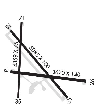
| Lat: N 4450.2 Long: W 11748.5 Elev: 3373 Var: -16 Longest Runway: 5084 | ||
| AWOS: 134.27 CTAF: 123.0 | ||
| |||||||||||||||||||||||
| |||||||||||||||||||||||
| |||||||||||||||||||||||
| Rwy | Rwy | |||||||
| 3670x140 | 3670' | 3670x140 | 3670' | |||||
| 5084x100 | 5084' | 5084x100 | 5084' | |||||
| 4359x75 | 4359' | 4359x75 | 3962' | |||||
| Runway ID | Single Wheel | Double Wheel | Double Tandem Wheel | Dual Double Wheel |
| 08/26 | 30,000 | N/A | N/A | N/A |
| 13/31 | 50,000 | 65,000 | N/A | N/A |
| 17/35 | 30,000 | N/A | N/A | N/A |
| These numbers are Advisory and are not limits. The Airport Manager should have more accurate Weight Limits | ||||
 Airport Diagram might not be current. | |
| Facility Name: | BAKER CITY MUNI |
| City Name: | BAKER CITY |
| County: | BAKER |
| State abbrev: | OR |
| State Name: | OREGON |
| Ownership: | PUBLICLY OWNED |
| Use: | OPEN TO THE PUBLIC |
| Owner's Name: | BAKER CITY |
| Address: | BOX 650 |
| BAKER CITY, OR 97814 | |
| Owner's Phone: | 541-523-6541 |
| Manager's Name: | TROY WOYDZIAK; ALSO MICHELLE OWEN (DIR. OF PUBLIC WORKS) 541-519-0180. PWDIRECTOR@BAKERCITY.GOV. |
| Address: | BOX 650 |
| BAKER CITY, OR 97814 | |
| Phone: | 541-523-5663 |
| FAA Region: | NORTHWEST MOUNTAIN |
| FAA Field Office: | SEA |
| Date | Sunrise | Sunset |
|---|---|---|
| 05/29/25 Thursday | 5:10 | 20:27 |
| 05/30/25 Friday | 5:10 | 20:28 |
| 05/31/25 Saturday | 5:09 | 20:29 |
| 06/01/25 Sunday | 5:08 | 20:30 |
| 06/02/25 Monday | 5:08 | 20:31 |
| 06/03/25 Tuesday | 5:07 | 20:32 |
| 06/04/25 Wednesday | 5:07 | 20:32 |
| 06/05/25 Thursday | 5:07 | 20:33 |
| 06/06/25 Friday | 5:06 | 20:34 |
| 06/07/25 Saturday | 5:06 | 20:35 |
| 06/08/25 Sunday | 5:05 | 20:35 |
| 06/09/25 Monday | 5:05 | 20:36 |
| 06/10/25 Tuesday | 5:05 | 20:37 |
| 06/11/25 Wednesday | 5:05 | 20:37 |
| Airport Attendance Schedule | OCT-APR 7 Days A Week 0700-1600, MAY-SEPT 7 Days A Week 0800-1700 |
| Airport Status | OPERATIONAL (This Status can change at any time - please check NOTAMS) |
| Airport Lighting Schedule | ACTVT REIL RWY 13 & 31; MIRL RWY 13/31 - CTAF. VASI RWY 13 OPR CONSLY. |
| Airport Storage Available | Tie Downs, Hanger |
| Extra Services Available | Charter, Flight Instruction, Aircraft Rental, Aircraft Sales |
| Wind Indicator | YES - (lighted) |
| Control Tower | NO |
| CTAF Frequency | 123.000 |
| Unicom Frequency | 123.000 |
| Rotating Beacon Color | WG |
| Segmented Circle | YES |
| Landing Fee | NO |
| Airport Inspected | STATE - performed by STATE AERONAUTICAL PERSONNEL |
| Inspection Date | 03/29/2022 |
| Type of Fuel Available | Grade 100LL, JET A (freeze point -40C) |
| Airframe Repair Service | MINOR |
| Power Plant Repair Service | MAJOR |
| Latitude | N4450.2 |
| Longitude | W11748.5 (ESTIMATED) |
| Arpt Elevation | 3373ft (SURVEYED) |
| Magnetic Variation | 16E |
| 3 miles N | of BAKER CITY |
| Traffic Pattern Altitude | |
| Sectional Chart | SEATTLE |
| Operations (Reported) | Yearly | Avg. Daily |
|---|---|---|
| General Aviation Transient | 0 | 0 |
| General Aviation Local | 0 | 0 |
| Air Taxi | 0 | 0 |
| Commerical | 0 | 0 |
| Commuter | 0 | 0 |
| Military | 0 | 0 |
| Aircraft based on Field | |
|---|---|
| General Aviation Singles | 0 |
| General Aviation Multi | 0 |
| Jet Aircraft | 0 |
| General Aviation Helicopters | 0 |
| Military Aircraft | 0 |
| Gliders | 0 |
| Ultralights | 0 |
| FSS on field | NO |
| FSS tie-in | MC MINNVILLE |
| FSS Phone | 1-800-WX-BRIEF |
| Who issues Notams | BKE |
| Notam D service at airport | YES |
| ARTCC Name | SALT LAKE CITY |
| Airport Certification | |
| Aircraft Rescue & Firefighting Index | None |
| Airport of Entry | No |
| Custom Landing Rights | No |
| Joint Civil/Military | No |
| Military Landing rights | YES |
| NATIONAL PLAN OF INTEGRATED AIRPORT SYSTEMS (NPIAS) |
| GRANT AGREEMENTS UNDER FAAP/ADAP/AIP |
| SURPLUS PROPERTY AGREEMENT UNDER PUBLIC LAW 289 |
| ASSURANCES PURSUANT TO TITLE VI, CIVIL RIGHTS ACT OF 1964 |
| AGREEMENT UNDER DLAND OR DCLA HAS EXPIRED. |
| BIRDS INVOF APRT. |
| COLD TEMPERATURE AIRPORT. ALTITUDE CORRECTION REQUIRED AT OR BELOW -23C. |
Airport Communications & Frequencies:
| |||||||||
| Runway: 08 | Runway: 26 | ||
| Mag heading: | 81° | Mag heading: | 261° |
| Rwy Slope: | -.01% Down | Rwy Slope: | .01% Up |
| Approach: | Approach: | ||
| Pattern: | Left Traffic | Pattern: | Left Traffic |
| Markings: | NUMBERS ONLY | Markings: | NUMBERS ONLY |
| Marking Condition: | FAIR | Marking Condition: | FAIR |
| Arresting Dev: | Arresting Dev: | ||
| Lat & Long: | N4450.2 W11748.9 | Lat. & Long.: | N4450.1 W11748.0 |
| Elev: | 3369.2 ft. MSL | Elev: | 3368.8 ft. MSL |
| TCH: | TCH: | ||
| Visual Glide Path: | Visual Glide Path: | ||
| Displaced Threshold: | No | Displaced Threshold: | No |
| Touchdown Zone: | YES | Touchdown Zone: | YES |
| Touchdown Elev.: | 3369.9 feet | Touchdown Elev.: | 3369.9 feet |
| Visual Glide Slope: | Visual Glide Slope: | ||
| RVR Equipment: | RVR Equipment: | ||
| RVV Equipment: | NO | RVV Equipment: | NO |
| Approach Lights: | Approach Lights: | ||
| REIL: | NO | REIL: | NO |
| Centerline Lights: | NO | Centerline Lights: | NO |
| Touchdown lights: | NO | Touchdown lights: | NO |
| Runway Category: | Runway with a Visual Approach | Runway Category: | Runway with a Visual Approach |
| Declared Distances: | Declared Distances: | ||
| Obstructions: | ROAD | Obstructions: | BRUSH |
| Marked: | NOT Marked/Lighted | Marked: | NOT Marked/Lighted |
| Clearance slope: | 5:1 | Clearance slope: | 1:1 |
| Obstruction height: | 16 feet AGL | Obstruction height: | 14 feet AGL |
| Dist. from runway: | 280 feet | Dist. from runway: | 225 feet |
| Centerline offset: | Centerline offset: | 20B | |
| Comments: | Comments: |
| Runway: 13 | Runway: 31 | ||
| Mag heading: | 126° | Mag heading: | 306° |
| Rwy Slope: | .15% Up | Rwy Slope: | -.15% Down |
| Approach: | Approach: | ||
| Pattern: | Left Traffic | Pattern: | Left Traffic |
| Markings: | NONPRECISION INSTRUMENT | Markings: | BASIC |
| Marking Condition: | GOOD | Marking Condition: | GOOD |
| Arresting Dev: | Arresting Dev: | ||
| Lat & Long: | N4450.5 W11748.8 | Lat. & Long.: | N4449.9 W11748.1 |
| Elev: | 3365.6 ft. MSL | Elev: | 3373.0 ft. MSL |
| TCH: | 47 ft. AGL | TCH: | |
| Visual Glide Path: | 3.00 degrees | Visual Glide Path: | |
| Displaced Threshold: | No | Displaced Threshold: | No |
| Touchdown Zone: | YES | Touchdown Zone: | YES |
| Touchdown Elev.: | 3370.2 feet | Touchdown Elev.: | 3373.2 feet |
| Visual Glide Slope: | 4-BOX VASI ON LEFT SIDE OF RUNWAY | Visual Glide Slope: | |
| RVR Equipment: | RVR Equipment: | ||
| RVV Equipment: | NO | RVV Equipment: | NO |
| Approach Lights: | Approach Lights: | ||
| REIL: | YES | REIL: | YES |
| Centerline Lights: | NO | Centerline Lights: | NO |
| Touchdown lights: | NO | Touchdown lights: | NO |
| Runway Category: | Runway with a Non-precision Approach having visibility minimums greater than 3/4 mile | Runway Category: | Runway with a Visual Approach |
| Declared Distances: | Declared Distances: | ||
| Obstructions: | ROAD | Obstructions: | ROAD |
| Marked: | NOT Marked/Lighted | Marked: | NOT Marked/Lighted |
| Clearance slope: | 14:1 | Clearance slope: | 21:1 |
| Obstruction height: | 20 feet AGL | Obstruction height: | 15 feet AGL |
| Dist. from runway: | 515 feet | Dist. from runway: | 515 feet |
| Centerline offset: | 230 right of centerline | Centerline offset: | 230 feet right of centerline |
| Comments: | Comments: |
| Runway: 17 | Runway: 35 | ||
| Mag heading: | 165° | Mag heading: | 345° |
| Rwy Slope: | .17% Up | Rwy Slope: | -.17% Down |
| Approach: | Approach: | ||
| Pattern: | Left Traffic | Pattern: | Left Traffic |
| Markings: | BASIC | Markings: | BASIC |
| Marking Condition: | GOOD | Marking Condition: | GOOD |
| Arresting Dev: | Arresting Dev: | ||
| Lat & Long: | N4450.7 W11748.8 | Lat. & Long.: | N4450.0 W11748.8 |
| Elev: | 3365.6 ft. MSL | Elev: | 3372.8 ft. MSL |
| TCH: | TCH: | ||
| Visual Glide Path: | Visual Glide Path: | ||
| Displaced Threshold: | No | Displaced Threshold: | 397 feet |
| Touchdown Zone: | YES | Touchdown Zone: | YES |
| Touchdown Elev.: | 3369.6 feet | Touchdown Elev.: | 3371.8 feet |
| Visual Glide Slope: | Visual Glide Slope: | ||
| RVR Equipment: | RVR Equipment: | ||
| RVV Equipment: | NO | RVV Equipment: | NO |
| Approach Lights: | Approach Lights: | ||
| REIL: | NO | REIL: | NO |
| Centerline Lights: | NO | Centerline Lights: | NO |
| Touchdown lights: | NO | Touchdown lights: | NO |
| Runway Category: | Runway with a Visual Approach | Runway Category: | Runway with a Visual Approach |
| Declared Distances: | Declared Distances: | ||
| Obstructions: | TREES | Obstructions: | |
| Marked: | NOT Marked/Lighted | Marked: | |
| Clearance slope: | 17:1 | Clearance slope: | 50:1; RWY 35 15 FT ROAD; DIST 110 FT; 14:1 BASED ON 397' DSPLCD THLD. |
| Obstruction height: | 27 feet AGL | Obstruction height: | |
| Dist. from runway: | 672 feet | Dist. from runway: | |
| Centerline offset: | 50 left of centerline | Centerline offset: | |
| Comments: | Comments: | RWY 35 +15 FT ROAD 110' FT FM RY END. |
Thanks for using FltPlan.com
all rights reserved © 1999-2025 by Flight Plan LLC

