
| MEADOWS FIELD BAKERSFIELD CA |
| |
| Lat: N 3526.0 Long: W 11903.5 Elev: 510 Var: -14 Longest Runway: 10849 | ||
| Dept. ATIS: 118.6 Arr. ATIS: 118.6 Ground: 121.7 Tower: 118.1 | ||
| |||||||||||||||||||||||||||||||||||||||||||||||||||||||||||||||||||
| |||||||||||||||||||||||||||||||||||||||||||||||||||||||||||||||||||
| |||||||||||||||||||||||||||||||||||||||||||||||||||||||||||||||||||
| |||||||||||||||||||||||||||||||||||||||||||||||||||||||||||||||||||
| |||||||||||||||||||||||||||||||||||||||||||||||||||||||||||||||||||
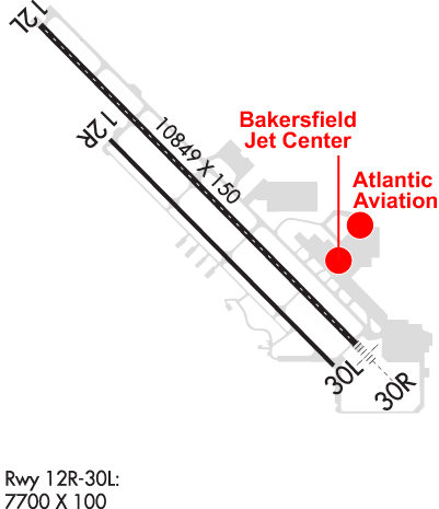
| Rwy | Rwy | |||||||
| 10849x150 | 10849' | 10849x150 | 7430' | 111.90 - 301° | ||||
| 7700x100 | 7700' | 7700x100 | 6201' | |||||
| Runway ID | Single Wheel | Double Wheel | Double Tandem Wheel | Dual Double Wheel |
| 12L/30R | 96,000 | 155,000 | 260,000 | 654,000 |
| 12R/30L | 18,000 | N/A | N/A | N/A |
| These numbers are Advisory and are not limits. The Airport Manager should have more accurate Weight Limits | ||||
 Airport Diagram might not be current. | |
| Facility Name: | MEADOWS FLD |
| City Name: | BAKERSFIELD |
| County: | KERN |
| State abbrev: | CA |
| State Name: | CALIFORNIA |
| Ownership: | PUBLICLY OWNED |
| Use: | OPEN TO THE PUBLIC |
| Owner's Name: | COUNTY OF KERN |
| Address: | DEPT OF ARPTS, 3701 WINGS WAY, #300, 3701 WINGS WAY, SUITE 300 |
| BAKERSFIELD, CA 93308 | |
| Owner's Phone: | 661-391-1800; RON BREWSTER - BREWSTERR@CO.KERN.CA.US |
| Manager's Name: | RON BREWSTER |
| Address: | 3701 WINGS WAY, #300 |
| BAKERSFIELD, CA 93308 | |
| Phone: | 661-391-1824; 24 HRS: (661) 391-1800 FAX: (661) 391-1801 |
| FAA Region: | WESTERN-PACIFIC |
| FAA Field Office: | LAX |
| Date | Sunrise | Sunset |
|---|---|---|
| 09/24/21 Friday | 6:46 | 18:50 |
| 09/25/21 Saturday | 6:46 | 18:49 |
| 09/26/21 Sunday | 6:47 | 18:47 |
| 09/27/21 Monday | 6:48 | 18:46 |
| 09/28/21 Tuesday | 6:49 | 18:45 |
| 09/29/21 Wednesday | 6:49 | 18:43 |
| 09/30/21 Thursday | 6:50 | 18:42 |
| 10/01/21 Friday | 6:51 | 18:40 |
| 10/02/21 Saturday | 6:52 | 18:39 |
| 10/03/21 Sunday | 6:53 | 18:37 |
| 10/04/21 Monday | 6:53 | 18:36 |
| 10/05/21 Tuesday | 6:54 | 18:35 |
| 10/06/21 Wednesday | 6:55 | 18:33 |
| 10/07/21 Thursday | 6:56 | 18:32 |
| Airport Attendance Schedule | CONTINUOUS |
| Airport Status | OPERATIONAL (This Status can change at any time - please check NOTAMS) |
| Airport Lighting Schedule | WHEN ATCT CLSD ACTVT MALSR RWY 30R; PAPI RWY 12L, 30R & 30L; HIRL RWY 12L/30R; MIRL RWY 12R/30L - CTAF. PAPI RWY 12R NOT OPR WHEN ATCT CLSD. |
| Airport Storage Available | Tie Downs |
| Extra Services Available | Air Freight, Air Ambulance, Avionics, Charter, Flight Instruction, Aircraft Rental, Aircraft Sales, Annual Surveying |
| Wind Indicator | YES - (lighted) |
| Control Tower | YES |
| CTAF Frequency | 118.100 |
| Unicom Frequency | 122.950 |
| Rotating Beacon Color | CLEAR-GREEN (Light Land Airport) |
| Segmented Circle | YES |
| Landing Fee | NO |
| Airport Inspected | FEDERAL - performed by FAA AIRPORTS FIELD PERSONNEL |
| Inspection Date | 06/06/2018 |
| Type of Fuel Available | Grade 100, Grade 100LL, JET A (freeze point -40C) |
| Airframe Repair Service | MAJOR |
| Power Plant Repair Service | MAJOR |
| Latitude | N3526.0 |
| Longitude | W11903.5 (ESTIMATED) |
| Arpt Elevation | 509ft (SURVEYED) |
| Magnetic Variation | 14E |
| 3 miles NW | of BAKERSFIELD |
| Traffic Pattern Altitude | |
| Sectional Chart | LOS ANGELES |
| Operations (Reported) | Yearly | Avg. Daily |
|---|---|---|
| General Aviation Transient | 30967 | 85 |
| General Aviation Local | 15181 | 42 |
| Air Taxi | 12387 | 34 |
| Commerical | 2575 | 7 |
| Commuter | 0 | 0 |
| Military | 119 | 0 |
| Aircraft based on Field | |
|---|---|
| General Aviation Singles | 108 |
| General Aviation Multi | 52 |
| Jet Aircraft | 32 |
| General Aviation Helicopters | 1 |
| Military Aircraft | 0 |
| Gliders | 0 |
| Ultralights | 1 |
| FSS on field | NO |
| FSS tie-in | RANCHO MURIETA |
| FSS Phone | 1-800-WX-BRIEF |
| Who issues Notams | BFL |
| Notam D service at airport | YES |
| ARTCC Name | LOS ANGELES |
| Airport Certification | AIRPORT RECEIVING SCHEDULED AIR CARRIER SERVICE FROM CARRIERS CERTIFICATED BY THE CIVIL AERONAUTICS BOARD; INDEX C ARFF AVAILABLE |
| Aircraft Rescue & Firefighting Index | AIRPORT HAS A CERTIFICATE UNDER CFR PART 139 |
| Airport of Entry | No |
| Custom Landing Rights | No |
| Joint Civil/Military | No |
| Military Landing rights | YES |
| NATIONAL PLAN OF INTEGRATED AIRPORT SYSTEMS (NPIAS) |
| GRANT AGREEMENTS UNDER FAAP/ADAP/AIP |
| SURPLUS PROPERTY AGREEMENT UNDER PUBLIC LAW 289 |
| ASSURANCES PURSUANT TO TITLE VI, CIVIL RIGHTS ACT OF 1964 |
| AGREEMENT UNDER DLAND OR DCLA HAS EXPIRED. |
| MIL HELICOPTERS MAKE ALL APCHS TO RY OR PAVED AREAS. MINIMIZE HOVERING & POWER TO AVOID CAUSING BLOWING DUST; WHEELED HELICOPTERS GND TAXI ONLY. FORMATION JOIN-UP AFT DEP ONLY. |
| RY 30R 50:1 TO DSPLD THLD. |
| ARPT OPS NA BLO 1200 RVR WITHOUT SMGCS. ARPT OPS NOT INITIATED BLO 600 RVR OR AUTH BLO 500 RVR. |
| RY 12R/30L NSTD HOLDING POSITION MARKINGS/SIGN LOCATIONS. |
| CAP SQUADRON ON ARPT. |
| RIGHT BASE OPNS FOR RY 30R ESTABLISH WINGS LEVEL ON FINAL APCH NO LOWER THAN 300 FT AGL. |
| NOISE SENSITIVE AREAS S & E OF ARPT RECOMMENDED TURBOJET TRNG HRS WKDAY 0800-2200 WKENDS 1200-2200; NO MORE THAN TEN PRACTICE APCHS PER HR. |
Airport Communications & Frequencies:
| |||||||||||||||||||||||||||||||||||
| Runway: 12L | Runway: 30R | ||
| Mag heading: | 121° | Mag heading: | 301° |
| Rwy Slope: | -.33% Down | Rwy Slope: | .33% Up |
| Approach: | Approach: | ILS/DME | |
| Pattern: | Left Traffic | Pattern: | Right Traffic |
| Markings: | PRECISION INSTRUMENT | Markings: | PRECISION INSTRUMENT |
| Marking Condition: | GOOD | Marking Condition: | GOOD |
| Arresting Dev: | Arresting Dev: | ||
| Lat & Long: | N3526.8 W11904.3 | Lat. & Long.: | N3525.5 W11902.7 |
| Elev: | 509.5 ft. MSL | Elev: | 474.2 ft. MSL |
| TCH: | 50 ft. AGL | TCH: | 51 ft. AGL |
| Visual Glide Path: | 3.00 degrees | Visual Glide Path: | 3.00 degrees |
| Displaced Threshold: | No | Displaced Threshold: | 3419 feet |
| Touchdown Zone: | YES | Touchdown Zone: | YES |
| Touchdown Elev.: | 509.6 feet | Touchdown Elev.: | 492.6 feet |
| Visual Glide Slope: | 4-Light PAPI on LEFT side of Runway | Visual Glide Slope: | 4-Light PAPI on LEFT side of Runway |
| RVR Equipment: | TOUCHDOWN-MIDFIELD-ROLLOUT | RVR Equipment: | TOUCHDOWN-MIDFIELD-ROLLOUT |
| RVV Equipment: | NO | RVV Equipment: | YES |
| Approach Lights: | Approach Lights: | MALSR - 1,400 foot medium intensity approach lighting system with runway alignment indicator lights | |
| REIL: | NO | REIL: | NO |
| Centerline Lights: | NO | Centerline Lights: | YES |
| Touchdown lights: | NO | Touchdown lights: | YES |
| Runway Category: | Runway with a Non-precision Approach having visibility minimums greater than 3/4 mile | Runway Category: | Precision Instrument Runway |
| Declared Distances: | TORA:10855' TODA:10855' ASDA:10855' LDA:10855' | Declared Distances: | TORA:10855' TODA:10855' ASDA:10855' LDA:7429' |
| Runway: 12R | Runway: 30L | ||
| Mag heading: | 121° | Mag heading: | 301° |
| Rwy Slope: | -.30% Down | Rwy Slope: | .30% Up |
| Approach: | Approach: | ||
| Pattern: | Right Traffic | Pattern: | Left Traffic |
| Markings: | BASIC | Markings: | BASIC |
| Marking Condition: | GOOD | Marking Condition: | GOOD |
| Arresting Dev: | Arresting Dev: | ||
| Lat & Long: | N3526.3 W11903.9 | Lat. & Long.: | N3525.4 W11902.8 |
| Elev: | 486.0 ft. MSL | Elev: | 463.0 ft. MSL |
| TCH: | 25 ft. AGL | TCH: | 25 ft. AGL |
| Visual Glide Path: | 3.00 degrees | Visual Glide Path: | 3.00 degrees |
| Displaced Threshold: | No | Displaced Threshold: | 1499 feet |
| Touchdown Zone: | YES | Touchdown Zone: | YES |
| Touchdown Elev.: | 486.0 feet | Touchdown Elev.: | 476.7 feet |
| Visual Glide Slope: | 4-Light PAPI on LEFT side of Runway | Visual Glide Slope: | 4-Light PAPI on LEFT side of Runway |
| RVR Equipment: | RVR Equipment: | ||
| RVV Equipment: | NO | RVV Equipment: | NO |
| Approach Lights: | Approach Lights: | ||
| REIL: | NO | REIL: | NO |
| Centerline Lights: | NO | Centerline Lights: | NO |
| Touchdown lights: | NO | Touchdown lights: | NO |
| Runway Category: | Runway with a Visual Approach | Runway Category: | Runway with a Visual Approach |
| Declared Distances: | TORA:7703' TODA:7703' ASDA:7703' LDA:7703' | Declared Distances: | TORA:7703' TODA:7703' ASDA:7703' LDA:6203' |
| Obstructions: | Obstructions: | TREE | |
| Marked: | Marked: | NOT Marked/Lighted | |
| Clearance slope: | 50:1 | Clearance slope: | 43:1 |
| Obstruction height: | Obstruction height: | 45 feet AGL | |
| Dist. from runway: | Dist. from runway: | 2150 feet | |
| Centerline offset: | Centerline offset: | 225 feet left of centerline | |
| Comments: | Comments: |
Thanks for using FltPlan.com
all rights reserved © 1999-2021 by Flight Plan LLC