
| BRADFORD RGNL BRADFORD PA |
| |
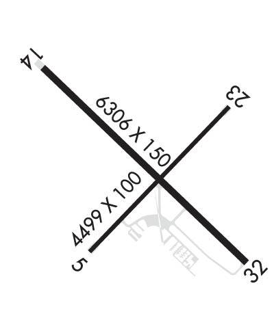
| Lat: N 4148.2 Long: W 07838.4 Elev: 2143 Var: +11 Longest Runway: 6307 | ||
| AWOS: 133.82 CTAF: 123.07 | ||
| ||||||
| ||||||
|
| Rwy | Rwy | |||||||
| 4499x100 | 4499' | 4499x100 | 4499' | |||||
| 6307x150 | 6307' | 6307x150 | 6307' | 108.30 - 324° | ||||
| Runway ID | Single Wheel | Double Wheel | Double Tandem Wheel | Dual Double Wheel |
| 05/23 | 48,000 | 60,000 | N/A | N/A |
| 14/32 | 48,000 | 60,000 | 92,000 | N/A |
| These numbers are Advisory and are not limits. The Airport Manager should have more accurate Weight Limits | ||||
 Airport Diagram might not be current. | |
| Facility Name: | BRADFORD RGNL |
| City Name: | BRADFORD |
| County: | MC KEAN |
| State abbrev: | PA |
| State Name: | PENNSYLVANIA |
| Ownership: | PUBLICLY OWNED |
| Use: | OPEN TO THE PUBLIC |
| Owner's Name: | BRADFORD REGIONAL ARPT AUTH |
| Address: | 212 AIRPORT DR SUITE E |
| LEWIS RUN, PA 16738 | |
| Owner's Phone: | 814-368-5928 |
| Manager's Name: | ALICIA DANKESREITER |
| Address: | 212 AIRPORT DR SUITE E |
| LEWIS RUN, PA 16738 | |
| Phone: | 814-368-5928; EXT 10 |
| FAA Region: | EASTERN |
| FAA Field Office: | HAR |
| Date | Sunrise | Sunset |
|---|---|---|
| 09/24/21 Friday | 7:04 | 19:09 |
| 09/25/21 Saturday | 7:05 | 19:07 |
| 09/26/21 Sunday | 7:06 | 19:05 |
| 09/27/21 Monday | 7:07 | 19:04 |
| 09/28/21 Tuesday | 7:08 | 19:02 |
| 09/29/21 Wednesday | 7:09 | 19:00 |
| 09/30/21 Thursday | 7:10 | 18:58 |
| 10/01/21 Friday | 7:11 | 18:57 |
| 10/02/21 Saturday | 7:12 | 18:55 |
| 10/03/21 Sunday | 7:13 | 18:53 |
| 10/04/21 Monday | 7:14 | 18:52 |
| 10/05/21 Tuesday | 7:15 | 18:50 |
| 10/06/21 Wednesday | 7:17 | 18:48 |
| 10/07/21 Thursday | 7:18 | 18:47 |
| Airport Attendance Schedule | 7 Days A Week 0700-2000 |
| Airport Status | OPERATIONAL (This Status can change at any time - please check NOTAMS) |
| Airport Lighting Schedule | ACTVT MALSR RWY 32; REIL RWY 05, 23 & 14; VASI RWY 14; PAPI RWY 23; MIRL RWY 05/23; HIRL RWY 14/32; TWY LGTS - CTAF. |
| Airport Storage Available | Hanger |
| Extra Services Available | Cargo Handling, Charter, Flight Instruction, Aircraft Rental |
| Wind Indicator | YES - (lighted) |
| Control Tower | NO |
| CTAF Frequency | 123.075 |
| Unicom Frequency | 123.075 |
| Rotating Beacon Color | CLEAR-GREEN (Light Land Airport) |
| Segmented Circle | NO |
| Landing Fee | YES |
| Airport Inspected | FEDERAL - performed by FAA AIRPORTS FIELD PERSONNEL |
| Inspection Date | 04/13/2021 |
| Type of Fuel Available | Grade 100LL, JET A |
| Airframe Repair Service | MINOR |
| Power Plant Repair Service | MINOR |
| Latitude | N4148.2 |
| Longitude | W07838.4 (ESTIMATED) |
| Arpt Elevation | 2143ft (SURVEYED) |
| Magnetic Variation | 11W |
| 10 miles S | of BRADFORD |
| Traffic Pattern Altitude | |
| Sectional Chart | DETROIT |
| Operations (Reported) | Yearly | Avg. Daily |
|---|---|---|
| General Aviation Transient | 339 | 1 |
| General Aviation Local | 79 | 0 |
| Air Taxi | 130 | 0 |
| Commerical | 2388 | 7 |
| Commuter | 0 | 0 |
| Military | 51 | 0 |
| Aircraft based on Field | |
|---|---|
| General Aviation Singles | 15 |
| General Aviation Multi | 0 |
| Jet Aircraft | 0 |
| General Aviation Helicopters | 0 |
| Military Aircraft | 0 |
| Gliders | 0 |
| Ultralights | 0 |
| FSS on field | NO |
| FSS tie-in | ALTOONA |
| FSS Phone | 1-800-WX-BRIEF |
| Who issues Notams | BFD |
| Notam D service at airport | YES |
| ARTCC Name | CLEVELAND |
| Airport Certification | AIRPORT RECEIVING SCHEDULED AIR CARRIER SERVICE FROM CARRIERS CERTIFICATED BY THE CIVIL AERONAUTICS BOARD; PPR 24 HRS FOR UNSKED ACFT OPS WITH MORE THAN 30 PSGR SEATS; CALL AMGR 814-368-5928 X 10. INDEX "B" COVERAGE AVBL 0700-2000; AFTER 2000 FOR EMERG CALL MCKEAN COUNTY 911 AT 814-887-4911. |
| Aircraft Rescue & Firefighting Index | AIRPORT HAS A CERTIFICATE UNDER CFR PART 139 |
| Airport of Entry | No |
| Custom Landing Rights | No |
| Joint Civil/Military | No |
| Military Landing rights | YES |
| NATIONAL PLAN OF INTEGRATED AIRPORT SYSTEMS (NPIAS) |
| GRANT AGREEMENTS UNDER FAAP/ADAP/AIP |
| COMPLIANCE WITH ACCESSIBILITY TO THE HANDICAPPED |
| ASSURANCES PURSUANT TO TITLE VI, CIVIL RIGHTS ACT OF 1964 |
| AGREEMENT UNDER DLAND OR DCLA HAS EXPIRED. |
| DEER & BIRDS ON & INVOF ARPT. |
| AIRCRAFT DEICING AVAIL |
| NO SNOW REMOVAL AVBL 2000-0700. |
| FOR CD CTC CLEVELAND ARTCC AT 440-774-0227. |
Airport Communications & Frequencies:
| |||||||||
| Runway: 05 | Runway: 23 | ||
| Mag heading: | 55° | Mag heading: | 235° |
| Rwy Slope: | .32% Up | Rwy Slope: | -.32% Down |
| Approach: | Approach: | ||
| Pattern: | Left Traffic | Pattern: | Left Traffic |
| Markings: | BASIC | Markings: | BASIC |
| Marking Condition: | GOOD | Marking Condition: | GOOD |
| Arresting Dev: | Arresting Dev: | ||
| Lat & Long: | N4147.9 W07838.7 | Lat. & Long.: | N4148.4 W07838.0 |
| Elev: | 2128.8 ft. MSL | Elev: | 2143.1 ft. MSL |
| TCH: | TCH: | 40 ft. AGL | |
| Visual Glide Path: | Visual Glide Path: | 3.00 degrees | |
| Displaced Threshold: | No | Displaced Threshold: | No |
| Touchdown Zone: | YES | Touchdown Zone: | YES |
| Touchdown Elev.: | 2128.8 feet | Touchdown Elev.: | 2143.1 feet |
| Visual Glide Slope: | Visual Glide Slope: | 4-Light PAPI on LEFT side of Runway | |
| RVR Equipment: | RVR Equipment: | ||
| RVV Equipment: | NO | RVV Equipment: | NO |
| Approach Lights: | Approach Lights: | ||
| REIL: | YES | REIL: | YES |
| Centerline Lights: | NO | Centerline Lights: | NO |
| Touchdown lights: | NO | Touchdown lights: | NO |
| Runway Category: | Runway with a Visual Approach | Runway Category: | Runway with a Visual Approach |
| Declared Distances: | TORA:4499' TODA:4499' ASDA:4499' LDA:4499' | Declared Distances: | TORA:4499' TODA:4499' ASDA:4499' LDA:4499' |
| Obstructions: | TREES | Obstructions: | |
| Marked: | NOT Marked/Lighted | Marked: | |
| Clearance slope: | 4:1 | Clearance slope: | 20:1 |
| Obstruction height: | 24 feet AGL | Obstruction height: | |
| Dist. from runway: | 314 feet | Dist. from runway: | |
| Centerline offset: | 254 left of centerline | Centerline offset: | |
| Comments: | Comments: |
| Runway: 14 | Runway: 32 | ||
| Mag heading: | 145° | Mag heading: | 325° |
| Rwy Slope: | -.13% Down | Rwy Slope: | .13% Up |
| Approach: | Approach: | ILS | |
| Pattern: | Left Traffic | Pattern: | Left Traffic |
| Markings: | PRECISION INSTRUMENT | Markings: | PRECISION INSTRUMENT |
| Marking Condition: | FAIR | Marking Condition: | FAIR |
| Arresting Dev: | Arresting Dev: | ||
| Lat & Long: | N4148.6 W07838.9 | Lat. & Long.: | N4147.8 W07837.9 |
| Elev: | 2108.2 ft. MSL | Elev: | 2100.2 ft. MSL |
| TCH: | 42 ft. AGL | TCH: | |
| Visual Glide Path: | 3.00 degrees | Visual Glide Path: | |
| Displaced Threshold: | No | Displaced Threshold: | No |
| Touchdown Zone: | YES | Touchdown Zone: | YES |
| Touchdown Elev.: | 2118.7 feet | Touchdown Elev.: | 2119.8 feet |
| Visual Glide Slope: | 4-BOX VASI ON LEFT SIDE OF RUNWAY | Visual Glide Slope: | |
| RVR Equipment: | RVR Equipment: | ||
| RVV Equipment: | NO | RVV Equipment: | NO |
| Approach Lights: | Approach Lights: | MALSR - 1,400 foot medium intensity approach lighting system with runway alignment indicator lights; MALSR UNMONITORED. | |
| REIL: | YES | REIL: | NO |
| Centerline Lights: | NO | Centerline Lights: | NO |
| Touchdown lights: | NO | Touchdown lights: | NO |
| Runway Category: | Runway with a Non-precision Approach having visibility minimums greater than 3/4 mile | Runway Category: | Precision Instrument Runway |
| Declared Distances: | TORA:6306' TODA:6306' ASDA:6306' LDA:6306' | Declared Distances: | TORA:6306' TODA:6306' ASDA:6306' LDA:6306' |
| Obstructions: | TREES | Obstructions: | POLE |
| Marked: | NOT Marked/Lighted | Marked: | NOT Marked/Lighted |
| Clearance slope: | 6:1 | Clearance slope: | 36:1 |
| Obstruction height: | 52 feet AGL | Obstruction height: | 28 feet AGL |
| Dist. from runway: | 556 feet | Dist. from runway: | 1217 feet |
| Centerline offset: | 537 right of centerline | Centerline offset: | 358 feet left of centerline |
| Comments: | Comments: |
Thanks for using FltPlan.com
all rights reserved © 1999-2021 by Flight Plan LLC
