
| HAWKER BEECHCRAFT CORP WICHITA KS |
| |
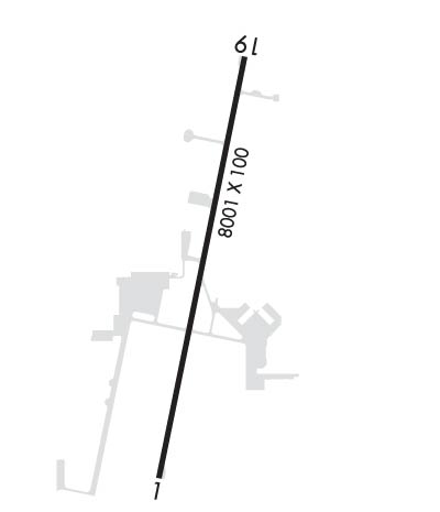
| Lat: N 3741.6 Long: W 09712.9 Elev: 1409 Var: -04 Longest Runway: 8001 | ||
| Clr Del: 125.0 tw cld Ground: 121.7 Tower: 126.8 | ||
| ||||||||||||||||||||||||||||||||
| ||||||||||||||||||||||||||||||||
| Rwy | Rwy | |||||||
| 8001x100 | 8001' | 8001x100 | 8001' | |||||
| Runway ID | Single Wheel | Double Wheel | Double Tandem Wheel | Dual Double Wheel |
| 01/19 | N/A | 75,000 | N/A | N/A |
| These numbers are Advisory and are not limits. The Airport Manager should have more accurate Weight Limits | ||||
 Airport Diagram might not be current. | |
| Facility Name: | BEECH FACTORY |
| City Name: | WICHITA |
| County: | SEDGWICK |
| State abbrev: | KS |
| State Name: | KANSAS |
| Ownership: | PRIVATELY OWNED |
| Use: | OPEN TO THE PUBLIC |
| Owner's Name: | BEECHCRAFT AIRCRAFT COMPANY |
| Address: | 10511 E. CENTRAL |
| WICHITA, KS 67201 | |
| Owner's Phone: | (316) 515-5300 |
| Manager's Name: | TODD BAYLESS |
| Address: | 10511 E. CENTRAL |
| WICHITA, KS 67201 | |
| Phone: | (316) 515-8365 |
| FAA Region: | CENTRAL |
| FAA Field Office: | NONE |
| Date | Sunrise | Sunset |
|---|---|---|
| 09/24/21 Friday | 7:18 | 19:23 |
| 09/25/21 Saturday | 7:19 | 19:21 |
| 09/26/21 Sunday | 7:20 | 19:20 |
| 09/27/21 Monday | 7:21 | 19:18 |
| 09/28/21 Tuesday | 7:22 | 19:17 |
| 09/29/21 Wednesday | 7:22 | 19:15 |
| 09/30/21 Thursday | 7:23 | 19:14 |
| 10/01/21 Friday | 7:24 | 19:12 |
| 10/02/21 Saturday | 7:25 | 19:11 |
| 10/03/21 Sunday | 7:26 | 19:09 |
| 10/04/21 Monday | 7:27 | 19:08 |
| 10/05/21 Tuesday | 7:28 | 19:06 |
| 10/06/21 Wednesday | 7:29 | 19:05 |
| 10/07/21 Thursday | 7:30 | 19:03 |
| Airport Attendance Schedule | MON-FRI 0700-1730 |
| Airport Status | OPERATIONAL (This Status can change at any time - please check NOTAMS) |
| Airport Lighting Schedule | WHEN ATCT CLSD ACTVT REIL RWY 01 AND 19; MIRL RWY 01/19 - CTAF. |
| Airport Storage Available | Tie Downs |
| Extra Services Available | NONE |
| Wind Indicator | YES - (lighted) |
| Control Tower | YES |
| CTAF Frequency | 126.800 |
| Unicom Frequency | 122.950 |
| Rotating Beacon Color | CLEAR-GREEN (Light Land Airport) |
| Segmented Circle | YES |
| Landing Fee | NO |
| Airport Inspected | STATE - performed by STATE AERONAUTICAL PERSONNEL |
| Inspection Date | 08/13/2019 |
| Type of Fuel Available | None |
| Airframe Repair Service | NONE |
| Power Plant Repair Service | NONE |
| Latitude | N3741.6 |
| Longitude | W09712.9 (ESTIMATED) |
| Arpt Elevation | 1408ft (SURVEYED) |
| Magnetic Variation | 04E |
| 5 miles E | of WICHITA |
| Traffic Pattern Altitude | |
| Sectional Chart | WICHITA |
| Operations (Reported) | Yearly | Avg. Daily |
|---|---|---|
| General Aviation Transient | 1700 | 5 |
| General Aviation Local | 26500 | 73 |
| Air Taxi | 0 | 0 |
| Commerical | 0 | 0 |
| Commuter | 0 | 0 |
| Military | 4500 | 12 |
| Aircraft based on Field | |
|---|---|
| General Aviation Singles | 21 |
| General Aviation Multi | 29 |
| Jet Aircraft | 10 |
| General Aviation Helicopters | 0 |
| Military Aircraft | 17 |
| Gliders | 0 |
| Ultralights | 0 |
| FSS on field | NO |
| FSS tie-in | WICHITA |
| FSS Phone | 1-800-WX-BRIEF |
| Who issues Notams | ICT |
| Notam D service at airport | YES |
| ARTCC Name | KANSAS CITY |
| Airport Certification | |
| Aircraft Rescue & Firefighting Index | None |
| Airport of Entry | No |
| Custom Landing Rights | No |
| Joint Civil/Military | No |
| Military Landing rights | No |
| ARR & DEP ACFT MAINTAIN 2200 FT MSL WITHIN 5 MILES OF FIELD DUE TO AFB TRAFFIC. |
| PRKG UNAVBL EXC 4 HRS PPR CALL 316-515-7140. |
| EXTENSIVE TRAINING ACTIVITIES |
| RWY 19 CALM WIND RWY. |
| ARRS FROM THE W CROSS MIDFIELD ENTER DNWND. |
| DEER, COYOTE & MIGRATORY WATER FOWL ON & INVOF ARPT. |
| PPR FOR PARKING OR TAXIING WEST SIDE OF RY. |
| BE ALERT COL JAMES JABARA ARPT 3 MILES NORTH 1/2 MILE WEST OF ARPT. |
Airport Communications & Frequencies:
| |||||||||||||||||||||||||||
| Runway: 01 | Runway: 19 | ||
| Mag heading: | 7° | Mag heading: | 187° |
| Rwy Slope: | .47% Up | Rwy Slope: | -.47% Down |
| Approach: | Approach: | ||
| Pattern: | Right Traffic | Pattern: | Left Traffic |
| Markings: | NONPRECISION INSTRUMENT | Markings: | NONPRECISION INSTRUMENT |
| Marking Condition: | GOOD | Marking Condition: | GOOD |
| Arresting Dev: | Arresting Dev: | ||
| Lat & Long: | N3741.0 W09713.1 | Lat. & Long.: | N3742.3 W09712.7 |
| Elev: | 1371.2 ft. MSL | Elev: | 1408.6 ft. MSL |
| TCH: | 45 ft. AGL | TCH: | 45 ft. AGL |
| Visual Glide Path: | 3.00 degrees | Visual Glide Path: | 3.00 degrees |
| Displaced Threshold: | No | Displaced Threshold: | No |
| Touchdown Zone: | YES | Touchdown Zone: | YES |
| Touchdown Elev.: | 1386.8 feet | Touchdown Elev.: | 1408.6 feet |
| Visual Glide Slope: | 4-Light PAPI on LEFT side of Runway | Visual Glide Slope: | 4-Light PAPI on LEFT side of Runway |
| RVR Equipment: | RVR Equipment: | ||
| RVV Equipment: | NO | RVV Equipment: | NO |
| Approach Lights: | Approach Lights: | ||
| REIL: | YES | REIL: | YES |
| Centerline Lights: | NO | Centerline Lights: | NO |
| Touchdown lights: | NO | Touchdown lights: | NO |
| Runway Category: | D | Runway Category: | D |
| Declared Distances: | Declared Distances: |
Thanks for using FltPlan.com
all rights reserved © 1999-2021 by Flight Plan LLC
