
| BOCA RATON BOCA RATON FL |
| |
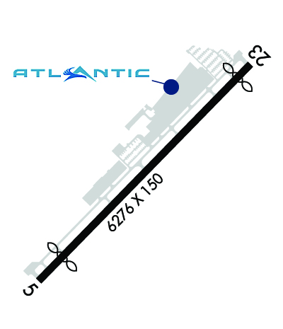
| Lat: N 2622.7 Long: W 08006.5 Elev: 13 Var: +05 Longest Runway: 6276 | ||
| Clr Del: 121.8 AWOS: 121.12 Ground: 121.8 Tower: 118.42 | ||
| ||||||||||||||||||||||||||||||||||||||||||||||||||||||||||||||||||||
| ||||||||||||||||||||||||||||||||||||||||||||||||||||||||||||||||||||
| ||||||||||||||||||||||||||||||||||||||||||||||||||||||||||||||||||||
| ||||||||||||||||||||||||||||||||||||||||||||||||||||||||||||||||||||
| ||||||||||||||||||||||||||||||||||||||||||||||||||||||||||||||||||||
| ||||||||||||||||||||||||||||||||||||||||||||||||||||||||||||||||||||
| FBOs at nearby airports who want your business: | |||||||||||||||||
| |||||||||||||||||
| Rwy | Rwy | |||||||
| 6276x150 | 5580' | 6276x150 | 5898' | |||||
| Runway ID | Single Wheel | Double Wheel | Double Tandem Wheel | Dual Double Wheel |
| 05/23 | 66,000 | 95,000 | N/A | N/A |
| These numbers are Advisory and are not limits. The Airport Manager should have more accurate Weight Limits | ||||
 Airport Diagram might not be current. | |
| Facility Name: | BOCA RATON |
| City Name: | BOCA RATON |
| County: | PALM BEACH |
| State abbrev: | FL |
| State Name: | FLORIDA |
| Ownership: | PUBLICLY OWNED |
| Use: | OPEN TO THE PUBLIC |
| Owner's Name: | BOCA RATON AIRPORT AUTHORITY |
| Address: | 903 NW 35TH STREET |
| BOCA RATON, FL 33431 | |
| Owner's Phone: | 561-391-2202 |
| Manager's Name: | CLARA BENNETT |
| Address: | 903 NW 35TH STREET |
| BOCA RATON, FL 33431 | |
| Phone: | 561-391-2202; EXT 211 |
| FAA Region: | SOUTHERN |
| FAA Field Office: | ORL |

| Date | Sunrise | Sunset |
|---|---|---|
| 09/24/21 Friday | 7:10 | 19:15 |
| 09/25/21 Saturday | 7:10 | 19:14 |
| 09/26/21 Sunday | 7:11 | 19:13 |
| 09/27/21 Monday | 7:11 | 19:12 |
| 09/28/21 Tuesday | 7:11 | 19:10 |
| 09/29/21 Wednesday | 7:12 | 19:09 |
| 09/30/21 Thursday | 7:12 | 19:08 |
| 10/01/21 Friday | 7:13 | 19:07 |
| 10/02/21 Saturday | 7:13 | 19:06 |
| 10/03/21 Sunday | 7:14 | 19:05 |
| 10/04/21 Monday | 7:14 | 19:04 |
| 10/05/21 Tuesday | 7:15 | 19:03 |
| 10/06/21 Wednesday | 7:15 | 19:02 |
| 10/07/21 Thursday | 7:16 | 19:01 |
| Airport Attendance Schedule | CONTINUOUS |
| Airport Status | OPERATIONAL (This Status can change at any time - please check NOTAMS) |
| Airport Lighting Schedule | WHEN ATCT CLSD ACTV REIL RWY 05 & 23, PAPI RWY 5 & 23; MIRL RWY 05/23 - CTAF. |
| Airport Storage Available | Tie Downs, Hanger |
| Extra Services Available | Avionics, Charter, Flight Instruction, Aircraft Rental |
| Wind Indicator | YES - (lighted) |
| Control Tower | YES |
| CTAF Frequency | 118.425 |
| Unicom Frequency | |
| Rotating Beacon Color | CLEAR-GREEN (Light Land Airport) |
| Segmented Circle | NO |
| Landing Fee | NO |
| Airport Inspected | STATE - performed by STATE AERONAUTICAL PERSONNEL |
| Inspection Date | 04/30/2018 |
| Type of Fuel Available | Grade 100LL, JET A (freeze point -40C) |
| Airframe Repair Service | MAJOR |
| Power Plant Repair Service | MAJOR |
| Latitude | N2622.7 |
| Longitude | W08006.5 (ESTIMATED) |
| Arpt Elevation | 13ft (SURVEYED) |
| Magnetic Variation | 05W |
| 2 miles NW | of BOCA RATON |
| Traffic Pattern Altitude | |
| Sectional Chart | MIAMI |
| Operations (Reported) | Yearly | Avg. Daily |
|---|---|---|
| General Aviation Transient | 33367 | 91 |
| General Aviation Local | 42791 | 117 |
| Air Taxi | 5289 | 14 |
| Commerical | 0 | 0 |
| Commuter | 0 | 0 |
| Military | 103 | 0 |
| Aircraft based on Field | |
|---|---|
| General Aviation Singles | 124 |
| General Aviation Multi | 29 |
| Jet Aircraft | 76 |
| General Aviation Helicopters | 3 |
| Military Aircraft | 0 |
| Gliders | 0 |
| Ultralights | 0 |
| FSS on field | NO |
| FSS tie-in | MIAMI |
| FSS Phone | 1-800-WX-BRIEF |
| Who issues Notams | MIA |
| Notam D service at airport | YES |
| ARTCC Name | MIAMI |
| Airport Certification | |
| Aircraft Rescue & Firefighting Index | None |
| Airport of Entry | No |
| Custom Landing Rights | No; US CUSTOMS USER FEE ARPT. |
| Joint Civil/Military | No |
| Military Landing rights | YES |
| NATIONAL PLAN OF INTEGRATED AIRPORT SYSTEMS (NPIAS) |
| GRANT AGREEMENTS UNDER FAAP/ADAP/AIP |
| SURPLUS PROPERTY AGREEMENT UNDER PUBLIC LAW 289 |
| ASSURANCES PURSUANT TO TITLE VI, CIVIL RIGHTS ACT OF 1964 |
| THIS AIRPORT HAS BEEN SURVEYED BY THE NATIONAL GEODETIC SURVEY. |
| NOISE ABATEMENT INFO - AMGR. VOLUNTARY NOISE ABATEMENT PROC IN EFCT ALL TIMES & ACFT. VOLUNTARY CURFEW 2200-0700. USE NBAA STD NOISE ABATEMENT APCH & DEP PROC. |
| FOR CD, IF UNA VIA GCO CTC PALM BEACH APCH AT 561-684-9047 OR 561-275-1430. |
| GCO AVBL ON FREQ 127.35 PALM BEACH CD. |
| BIRDS ON AND INVOF ARPT. |
| USE RECOMMENDED DEP: RWY 05 L TURN HDG 360 STAY W OF INTERSTATE TO 1500 FT; RWY 23 R TURN HDG 255 AS SOON AS PRACTICABLE AFT PASSING RWY END TO 1500 FT; AVOID RESIDENTIAL AREAS; OVERFLY MALL AREA. |
| TGL VOLUNTARILY RSTRD TO 0900-1700 MON-FRI; STOP & GO LNGS & INT DEP VOLUNTARY RSTRD. |
| MAINT RUNUP NA 0100-1300. |
| ACFT PRKG LTD DURG VIP TFR PDS. TRAN ACFT RQRD TO OBTAIN PPR FM CHOSEN FBO PRIOR TO DEP. PPR SHALL BE INCLD IN IFR FP |
| US CUSTS USER FEE ARPT. US CUSTS AVBL THUR-MON 1030-1830 LCL - 561-292-9231. CLSD TO ARR OUTSIDE NML HR EXC O/R AND APVL BY US CUSTS; MNM ADDNL FEE. CTC US CUSTS 561-665-5842 FOR AFT HR APVL. |
Airport Communications & Frequencies:
| ||||||||||||||||||
| Runway: 05 | Runway: 23 | ||
| Mag heading: | 49° | Mag heading: | 229° |
| Rwy Slope: | .02% Up | Rwy Slope: | -.02% Down |
| Approach: | Approach: | ||
| Pattern: | Left Traffic | Pattern: | Right Traffic |
| Markings: | NONPRECISION INSTRUMENT | Markings: | NONPRECISION INSTRUMENT |
| Marking Condition: | FAIR | Marking Condition: | FAIR |
| Arresting Dev: | EMAS; ENGINEERED MATERIALS ARRESTING SYS (EMAS) 252 FT IN LEN BY 170 FT IN WID LCTD AT THE DER 05. | Arresting Dev: | EMAS; ENGINEERED MATERIALS ARRESTING SYS (EMAS) 300 FT IN LEN BY 170 FT IN WID LCTD AT THE DER 23. |
| Lat & Long: | N2622.3 W08006.9 | Lat. & Long.: | N2623.1 W08006.1 |
| Elev: | 11.4 ft. MSL | Elev: | 12.6 ft. MSL |
| TCH: | 40 ft. AGL | TCH: | 22 ft. AGL |
| Visual Glide Path: | 3.25 degrees | Visual Glide Path: | 3.25 degrees |
| Displaced Threshold: | 696 feet | Displaced Threshold: | 378 feet |
| Touchdown Zone: | YES | Touchdown Zone: | YES |
| Touchdown Elev.: | 11.9 feet | Touchdown Elev.: | 12.6 feet |
| Visual Glide Slope: | 4-Light PAPI on RIGHT side of Runway | Visual Glide Slope: | 4-Light PAPI on LEFT side of Runway |
| RVR Equipment: | RVR Equipment: | ||
| RVV Equipment: | NO | RVV Equipment: | NO |
| Approach Lights: | Approach Lights: | ||
| REIL: | YES | REIL: | YES |
| Centerline Lights: | NO | Centerline Lights: | NO |
| Touchdown lights: | NO | Touchdown lights: | NO |
| Runway Category: | Runway with a Non-precision Approach having visibility minimums greater than 3/4 mile | Runway Category: | Runway with a Non-precision Approach having visibility minimums greater than 3/4 mile |
| Declared Distances: | TORA:6276' TODA:6276' ASDA:6276' LDA:5580' | Declared Distances: | TORA:6276' TODA:6276' ASDA:6276' LDA:5898' |
| Obstructions: | TREES | Obstructions: | ROAD |
| Marked: | NOT Marked/Lighted | Marked: | LIGHTED |
| Clearance slope: | 14:1; APCH SLOPE 43:1 TO DSPLCD THLD DUE TO +26 FT TREE 60 FT RIGHT OF CNTRLN 675 FT FM RWY END. | Clearance slope: | 4:1; APCH SLOPE 35:1 TO DSPLCD THLD DUE TO TREES 25 FT RIGHT; 890 FT FM END OF RWY. |
| Obstruction height: | 33 feet AGL | Obstruction height: | 15 feet AGL |
| Dist. from runway: | 675 feet | Dist. from runway: | 270 feet |
| Centerline offset: | 60 right of centerline | Centerline offset: | 250 feet right of centerline |
| Comments: | Comments: |
Thanks for using FltPlan.com
all rights reserved © 1999-2021 by Flight Plan LLC


