
| ARLINGTON MUNI ARLINGTON WA |
| |
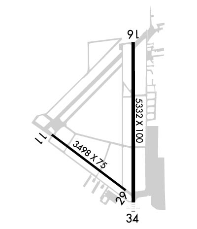
| Lat: N 4809.6 Long: W 12209.5 Elev: 142 Var: -17 Longest Runway: 5332 | ||
| Clr Del: 121.72 AWOS: 135.62 CTAF: 122.72 | ||
| ||||||||||||||||||||||||||||||||||||||||||||
| ||||||||||||||||||||||||||||||||||||||||||||
| ||||||||||||||||||||||||||||||||||||||||||||
| Rwy | Rwy | |||||||
| 3498x75 | 3498' | 3498x75 | 3498' | |||||
| 5332x100 | 5332' | 5332x100 | 5332' | 111.50 - 342° | ||||
| Runway ID | Single Wheel | Double Wheel | Double Tandem Wheel | Dual Double Wheel |
| 11/29 | 32,000 | 34,000 | 59,000 | N/A |
| 16/34 | 114,000 | 150,000 | 270,000 | N/A |
| These numbers are Advisory and are not limits. The Airport Manager should have more accurate Weight Limits | ||||
 Airport Diagram might not be current. | |
| Facility Name: | ARLINGTON MUNI |
| City Name: | ARLINGTON |
| County: | SNOHOMISH |
| State abbrev: | WA |
| State Name: | WASHINGTON |
| Ownership: | PUBLICLY OWNED |
| Use: | OPEN TO THE PUBLIC |
| Owner's Name: | CITY OF ARLINGTON |
| Address: | CITY HALL, 238 N OLYMPIC |
| ARLINGTON, WA 98223 | |
| Owner's Phone: | 360-403-3470 |
| Manager's Name: | MARTY WRAY |
| Address: | 18204 59TH AVE NE, STE A |
| ARLINGTON, WA 98223 | |
| Phone: | 360-403-3471 |
| FAA Region: | NORTHWEST MOUNTAIN |
| FAA Field Office: | SEA |
| Date | Sunrise | Sunset |
|---|---|---|
| 05/20/26 Wednesday | 5:23 | 20:47 |
| 05/21/26 Thursday | 5:22 | 20:49 |
| 05/22/26 Friday | 5:21 | 20:50 |
| 05/23/26 Saturday | 5:20 | 20:51 |
| 05/24/26 Sunday | 5:19 | 20:52 |
| 05/25/26 Monday | 5:18 | 20:53 |
| 05/26/26 Tuesday | 5:17 | 20:54 |
| 05/27/26 Wednesday | 5:16 | 20:56 |
| 05/28/26 Thursday | 5:16 | 20:57 |
| 05/29/26 Friday | 5:15 | 20:58 |
| 05/30/26 Saturday | 5:14 | 20:59 |
| 05/31/26 Sunday | 5:13 | 21:00 |
| 06/01/26 Monday | 5:13 | 21:01 |
| 06/02/26 Tuesday | 5:12 | 21:02 |
| Airport Attendance Schedule | M-F 0800-1700 |
| Airport Status | OPERATIONAL (This Status can change at any time - please check NOTAMS) |
| Airport Lighting Schedule | REIL RWY 11 & 29 OPR SS-SR; PAPI RWY 11, 16, 29 & 34 OPR CONSLY. ACTVT MALS RWY 34; REILS RWY 16; RWY 16/34 EDGE LIGHTS; TWY LGTS CTAF. |
| Airport Storage Available | Tie Downs |
| Extra Services Available | Air Ambulance, Avionics, Cargo Handling, Charter, Glider, Flight Instruction, Aircraft Rental, Aircraft Sales, Annual Surveying, Glider Towing |
| Wind Indicator | YES - (lighted) |
| Control Tower | NO |
| CTAF Frequency | 122.725 |
| Unicom Frequency | |
| Rotating Beacon Color | WG |
| Segmented Circle | YES |
| Landing Fee | NO |
| Airport Inspected | STATE - performed by STATE AERONAUTICAL PERSONNEL |
| Inspection Date | 09/18/2023 |
| Type of Fuel Available | Grade 100LL, JET A (freeze point -40C); -A PHONE 360-435-5700 FOR AFTER HRS SVC.; -10100L FUEL AVBL 24 HR CREDIT CARD SVC. |
| Airframe Repair Service | MAJOR |
| Power Plant Repair Service | MAJOR |
| Latitude | N4809.6 |
| Longitude | W12209.5 (ESTIMATED) |
| Arpt Elevation | 141ft (SURVEYED) |
| Magnetic Variation | 17E |
| 3 miles SW | of ARLINGTON |
| Traffic Pattern Altitude | 1058; TPA FOR ULTRALGTS 542 (400), HELICOPTERS 642 (500). |
| Sectional Chart | SEATTLE |
| Operations (Reported) | Yearly | Avg. Daily |
|---|---|---|
| General Aviation Transient | 0 | 0 |
| General Aviation Local | 0 | 0 |
| Air Taxi | 0 | 0 |
| Commerical | 0 | 0 |
| Commuter | 0 | 0 |
| Military | 0 | 0 |
| Aircraft based on Field | |
|---|---|
| General Aviation Singles | 0 |
| General Aviation Multi | 0 |
| Jet Aircraft | 0 |
| General Aviation Helicopters | 0 |
| Military Aircraft | 0 |
| Gliders | 0 |
| Ultralights | 0 |
| FSS on field | NO |
| FSS tie-in | SEATTLE |
| FSS Phone | 1-800-WX-BRIEF |
| Who issues Notams | AWO |
| Notam D service at airport | YES |
| ARTCC Name | SEATTLE |
| Airport Certification | |
| Aircraft Rescue & Firefighting Index | None |
| Airport of Entry | No |
| Custom Landing Rights | No |
| Joint Civil/Military | No |
| Military Landing rights | YES |
| NATIONAL PLAN OF INTEGRATED AIRPORT SYSTEMS (NPIAS) |
| GRANT AGREEMENTS UNDER FAAP/ADAP/AIP |
| SURPLUS PROPERTY AGREEMENT UNDER PUBLIC LAW 289 |
| ASSURANCES PURSUANT TO TITLE VI, CIVIL RIGHTS ACT OF 1964 |
| GLIDER OPERATIONS AT ARPT DAILY. |
| RWY 11/29 TURF LCTD BTN D2 AND D3 DIMENSIONS 1400 FT X 100 FT. |
| ULTRALIGHT AND POWERED PARACHUTE OPS DAILY WEST OF RWY 16/34 |
| WILDLIFE ON AND INVOF ARPT. ALTERNATE PHONE NUMBER FOR AIRPORT: 360-403-3470 |
| WINTER WEATHER OPERATIONS AND REPORTING MONDAY-FRIDAY 1600-0000Z. |
| FOR ADDNL DETAILS & RULES ON LOCAL PROCS CALL 360-403-3470. |
| FOR CD WHEN ATCT IS CLSD CTC SEATTLE APCH AT 206-214-4722. |
| GLIDER TURF PARALLEL EAST OF RWY 16/34, FULL LENGTH DIMENSIONS 3450 FT X 145 FT. |
| RWY 16/3 4 RWY 34 CALM WIND RWY. |
Airport Communications & Frequencies:
| ||||||||||||||
| Runway: 11 | Runway: 29 | ||
| Mag heading: | 110° | Mag heading: | 290° |
| Rwy Slope: | -.12% Down | Rwy Slope: | .12% Up |
| Approach: | Approach: | ||
| Pattern: | Right Traffic | Pattern: | Left Traffic |
| Markings: | BASIC | Markings: | BASIC |
| Marking Condition: | GOOD | Marking Condition: | GOOD |
| Arresting Dev: | Arresting Dev: | ||
| Lat & Long: | N4809.7 W12210.1 | Lat. & Long.: | N4809.4 W12209.4 |
| Elev: | 132.4 ft. MSL | Elev: | 128.2 ft. MSL |
| TCH: | 42 ft. AGL | TCH: | 40 ft. AGL |
| Visual Glide Path: | 3.50 degrees | Visual Glide Path: | 4.00 degrees |
| Displaced Threshold: | No | Displaced Threshold: | No |
| Touchdown Zone: | YES | Touchdown Zone: | YES |
| Touchdown Elev.: | 132.6 feet | Touchdown Elev.: | 130.7 feet |
| Visual Glide Slope: | 2-Light PAPI on LEFT side of Runway | Visual Glide Slope: | 2-Light PAPI on LEFT side of Runway |
| RVR Equipment: | RVR Equipment: | ||
| RVV Equipment: | NO | RVV Equipment: | NO |
| Approach Lights: | Approach Lights: | ||
| REIL: | YES | REIL: | YES |
| Centerline Lights: | NO | Centerline Lights: | NO |
| Touchdown lights: | NO | Touchdown lights: | NO |
| Runway Category: | Runway with a Visual Approach | Runway Category: | Runway with a Visual Approach |
| Declared Distances: | Declared Distances: | ||
| Obstructions: | Obstructions: | TREE | |
| Marked: | Marked: | NOT Marked/Lighted | |
| Clearance slope: | 50:1 | Clearance slope: | 21:1 |
| Obstruction height: | Obstruction height: | 176 feet AGL | |
| Dist. from runway: | Dist. from runway: | 3967 feet | |
| Centerline offset: | Centerline offset: | 465 feet right of centerline | |
| Comments: | Comments: |
| Runway: 16 | Runway: 34 | ||
| Mag heading: | 162° | Mag heading: | 342° |
| Rwy Slope: | -.25% Down | Rwy Slope: | .25% Up |
| Approach: | Approach: | LOCALIZER | |
| Pattern: | Right Traffic | Pattern: | Left Traffic |
| Markings: | NONPRECISION INSTRUMENT | Markings: | NONPRECISION INSTRUMENT |
| Marking Condition: | GOOD | Marking Condition: | GOOD |
| Arresting Dev: | Arresting Dev: | ||
| Lat & Long: | N4810.2 W12209.4 | Lat. & Long.: | N4809.3 W12209.4 |
| Elev: | 140.9 ft. MSL | Elev: | 127.5 ft. MSL |
| TCH: | 40 ft. AGL | TCH: | 36 ft. AGL |
| Visual Glide Path: | 3.00 degrees | Visual Glide Path: | 3.00 degrees |
| Displaced Threshold: | No | Displaced Threshold: | No |
| Touchdown Zone: | YES | Touchdown Zone: | YES |
| Touchdown Elev.: | 141.8 feet | Touchdown Elev.: | 135.4 feet |
| Visual Glide Slope: | 2-Light PAPI on LEFT side of Runway | Visual Glide Slope: | 2-Light PAPI on LEFT side of Runway |
| RVR Equipment: | RVR Equipment: | ||
| RVV Equipment: | NO | RVV Equipment: | NO |
| Approach Lights: | Approach Lights: | MALS - 1,400 foot medium intensity approach lighting system | |
| REIL: | YES | REIL: | NO |
| Centerline Lights: | NO | Centerline Lights: | NO |
| Touchdown lights: | NO | Touchdown lights: | NO |
| Runway Category: | Runway with a Visual Approach | Runway Category: | Runway with a Non-precision Approach having visibility minimums greater than 3/4 mile |
| Declared Distances: | Declared Distances: | ||
| Obstructions: | TREE | Obstructions: | |
| Marked: | NOT Marked/Lighted | Marked: | |
| Clearance slope: | 22:1 | Clearance slope: | 50:1 |
| Obstruction height: | 92 feet AGL | Obstruction height: | |
| Dist. from runway: | 2287 feet | Dist. from runway: | |
| Centerline offset: | 200 left of centerline | Centerline offset: | |
| Comments: | Comments: |
Thanks for using FltPlan.com
all rights reserved © 1999-2026 by Flight Plan LLC
