| WILKES-BARRE/SCRANTON INTL WILKES-BARRE/SCRANTN PA |
| |
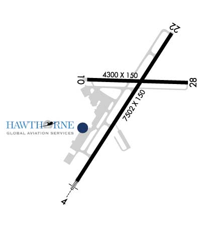
| Lat: N 4120.3 Long: W 07543.4 Elev: 962 Var: +11 Longest Runway: 7502 | ||
| Dept. ATIS: 111.6 Arr. ATIS: 111.6 Ground: 121.9 Tower: 120.1 | ||
| |||||||||||||||||||||||||||||||||||||||||||||||||||||||||||||||||||||
| |||||||||||||||||||||||||||||||||||||||||||||||||||||||||||||||||||||
| |||||||||||||||||||||||||||||||||||||||||||||||||||||||||||||||||||||
| Rwy | Rwy | |||||||
| 7502x150 | 7502' | 109.90 - 045° | 7502x150 | 7502' | 109.90 - 225° | |||
| 4300x150 | 4300' | 4300x150 | 4300' | |||||
| Runway ID | Single Wheel | Double Wheel | Double Tandem Wheel | Dual Double Wheel |
| 04/22 | 133,000 | 173,000 | 300,000 | N/A |
| 10/28 | 58,000 | 80,000 | 125,000 | N/A |
| These numbers are Advisory and are not limits. The Airport Manager should have more accurate Weight Limits | ||||
 Airport Diagram might not be current. | |
| Facility Name: | WILKES-BARRE/SCRANTON INTL |
| City Name: | WILKES-BARRE/SCRANTON |
| County: | LUZERNE |
| State abbrev: | PA |
| State Name: | PENNSYLVANIA |
| Ownership: | PUBLICLY OWNED |
| Use: | OPEN TO THE PUBLIC |
| Owner's Name: | LUZERNE AND LACKAWANNA CO |
| Address: | 100 TERMINAL DRIVE |
| AVOCA, PA 18641 | |
| Owner's Phone: | (570) 602-2040 |
| Manager's Name: | CARL R. BEARDSLEY, JR. |
| Address: | 100 TERMINAL DRIVE |
| AVOCA, PA 18641 | |
| Phone: | 570-602-2000 |
| FAA Region: | EASTERN |
| FAA Field Office: | HAR |
| Date | Sunrise | Sunset |
|---|---|---|
| 09/24/21 Friday | 6:52 | 18:57 |
| 09/25/21 Saturday | 6:53 | 18:55 |
| 09/26/21 Sunday | 6:54 | 18:54 |
| 09/27/21 Monday | 6:55 | 18:52 |
| 09/28/21 Tuesday | 6:56 | 18:50 |
| 09/29/21 Wednesday | 6:57 | 18:49 |
| 09/30/21 Thursday | 6:58 | 18:47 |
| 10/01/21 Friday | 6:59 | 18:45 |
| 10/02/21 Saturday | 7:00 | 18:43 |
| 10/03/21 Sunday | 7:01 | 18:42 |
| 10/04/21 Monday | 7:02 | 18:40 |
| 10/05/21 Tuesday | 7:04 | 18:38 |
| 10/06/21 Wednesday | 7:05 | 18:37 |
| 10/07/21 Thursday | 7:06 | 18:35 |
| Airport Attendance Schedule | CONTINUOUS |
| Airport Status | OPERATIONAL (This Status can change at any time - please check NOTAMS) |
| Airport Lighting Schedule | |
| Airport Storage Available | Tie Downs, Hanger |
| Extra Services Available | Air Freight, Avionics, Cargo Handling, Charter, Flight Instruction, Aircraft Rental |
| Wind Indicator | YES - (lighted) |
| Control Tower | YES |
| CTAF Frequency | |
| Unicom Frequency | 122.950 |
| Rotating Beacon Color | CLEAR-GREEN (Light Land Airport) |
| Segmented Circle | NO |
| Landing Fee | YES |
| Airport Inspected | FEDERAL - performed by FAA AIRPORTS FIELD PERSONNEL |
| Inspection Date | 02/04/2021 |
| Type of Fuel Available | Grade 100LL, JET A (freeze point -40C) |
| Airframe Repair Service | MAJOR |
| Power Plant Repair Service | MINOR |
| Latitude | N4120.3 |
| Longitude | W07543.4 (ESTIMATED) |
| Arpt Elevation | 961ft (SURVEYED) |
| Magnetic Variation | 11W |
| 5 miles SW | of WILKES-BARRE/SCRANTON |
| Traffic Pattern Altitude | |
| Sectional Chart | NEW YORK |
| Operations (Reported) | Yearly | Avg. Daily |
|---|---|---|
| General Aviation Transient | 10830 | 30 |
| General Aviation Local | 19631 | 54 |
| Air Taxi | 7584 | 21 |
| Commerical | 2351 | 6 |
| Commuter | 0 | 0 |
| Military | 435 | 1 |
| Aircraft based on Field | |
|---|---|
| General Aviation Singles | 23 |
| General Aviation Multi | 12 |
| Jet Aircraft | 2 |
| General Aviation Helicopters | 2 |
| Military Aircraft | 0 |
| Gliders | 0 |
| Ultralights | 0 |
| FSS on field | NO |
| FSS tie-in | WILLIAMSPORT |
| FSS Phone | 1-800-WX-BRIEF |
| Who issues Notams | AVP |
| Notam D service at airport | YES |
| ARTCC Name | NEW YORK |
| Airport Certification | AIRPORT RECEIVING SCHEDULED AIR CARRIER SERVICE FROM CARRIERS CERTIFICATED BY THE CIVIL AERONAUTICS BOARD; INDEX "C" ARFF EQUIPMENT AVAILABLE UPON REQUEST CALL 570-602-2040. |
| Aircraft Rescue & Firefighting Index | AIRPORT HAS A CERTIFICATE UNDER CFR PART 139 |
| Airport of Entry | No |
| Custom Landing Rights | YES |
| Joint Civil/Military | No |
| Military Landing rights | YES |
| NATIONAL PLAN OF INTEGRATED AIRPORT SYSTEMS (NPIAS) |
| GRANT AGREEMENTS UNDER FAAP/ADAP/AIP |
| ASSURANCES PURSUANT TO TITLE VI, CIVIL RIGHTS ACT OF 1964 |
| COMPLIANCE WITH ACCESSIBILITY TO THE HANDICAPPED |
| AGREEMENT UNDER DLAND OR DCLA HAS EXPIRED. |
| DEER & BIRDS ON & INVOF ARPT. |
| RY 28 UNLGTD HIGH TERRAIN TREES: 1155 FT MSL .91 MI EAST AER 28; 1463 FT MSL 1.49 MI EAST-SOUTHEAST AER 28; 1667 FT MSL 2.25 MI EAST AER 28; 1920 FT MSL 2.84 MI EAST AER 28. |
| UNLGTD TOWER 1130 FT MSL (20 FT AGL) 1.3 MI EAST AER 28; UNLGTD TOWER 1463 FT MSL (20 FT AGL) 1.7 MI EAST AER 28; UNLGTD TOWER 1652 FT MSL (20 FT AGL) 2.4 MI EAST AER 28. |
| FOR FBO SERVICE 0000-0500 LOCAL M-F AND 2100-0000 LOCAL SAT-SUN CALL (570) 457-4485. |
| RWY 04/2 2 PRECIPITOUS DROP-OFF EACH RY END. |
Airport Communications & Frequencies:
| ||||||||||||||||||||||||||||
| Runway: 04 | Runway: 22 | ||
| Mag heading: | 44° | Mag heading: | 224° |
| Rwy Slope: | -.67% Down | Rwy Slope: | .67% Up |
| Approach: | ILS/DME | Approach: | ILS/DME |
| Pattern: | Left Traffic | Pattern: | Right Traffic |
| Markings: | PRECISION INSTRUMENT | Markings: | PRECISION INSTRUMENT |
| Marking Condition: | GOOD | Marking Condition: | GOOD |
| Arresting Dev: | EMAS; ENGINEERED MATERIAL ARRESTING SYSTEM (EMAS) 324 FT IN LENGTH BY 170 FT IN WIDTH LCTD 50 FT OFF DER 04. | Arresting Dev: | EMAS; ENGINEERED MATERIAL ARRESTING SYSTEM (EMAS) 162 FT IN LENGTH BY 170 FT IN WIDTH LCTD 35 FT OFF DER 22. |
| Lat & Long: | N4119.7 W07543.9 | Lat. & Long.: | N4120.8 W07543.0 |
| Elev: | 961.7 ft. MSL | Elev: | 911.3 ft. MSL |
| TCH: | 58 ft. AGL | TCH: | 54 ft. AGL |
| Visual Glide Path: | 3.00 degrees | Visual Glide Path: | 3.00 degrees |
| Displaced Threshold: | No | Displaced Threshold: | No |
| Touchdown Zone: | YES | Touchdown Zone: | YES |
| Touchdown Elev.: | 961.7 feet | Touchdown Elev.: | 933.1 feet |
| Visual Glide Slope: | 4-Light PAPI on RIGHT side of Runway | Visual Glide Slope: | 4-BOX VASI ON LEFT SIDE OF RUNWAY |
| RVR Equipment: | TOUCHDOWN-ROLLOUT | RVR Equipment: | TOUCHDOWN-ROLLOUT |
| RVV Equipment: | NO | RVV Equipment: | NO |
| Approach Lights: | MALSR - 1,400 foot medium intensity approach lighting system with runway alignment indicator lights | Approach Lights: | |
| REIL: | NO | REIL: | YES |
| Centerline Lights: | NO | Centerline Lights: | NO |
| Touchdown lights: | NO | Touchdown lights: | NO |
| Runway Category: | Precision Instrument Runway | Runway Category: | Precision Instrument Runway |
| Declared Distances: | TORA:7501' TODA:7501' ASDA:7501' LDA:7501' | Declared Distances: | TORA:7501' TODA:7501' ASDA:7501' LDA:7501' |
| Obstructions: | Obstructions: | TOWER | |
| Marked: | Marked: | MARKED and LIGHTED | |
| Clearance slope: | 50:1 | Clearance slope: | 41:1 |
| Obstruction height: | Obstruction height: | 155 feet AGL | |
| Dist. from runway: | Dist. from runway: | 6529 feet | |
| Centerline offset: | Centerline offset: | 686 feet right of centerline | |
| Comments: | Comments: |
| Runway: 10 | Runway: 28 | ||
| Mag heading: | 103° | Mag heading: | 283° |
| Rwy Slope: | .29% Up | Rwy Slope: | -.29% Down |
| Approach: | Approach: | ||
| Pattern: | Right Traffic | Pattern: | Right Traffic |
| Markings: | NONPRECISION INSTRUMENT | Markings: | NONPRECISION INSTRUMENT |
| Marking Condition: | GOOD | Marking Condition: | GOOD |
| Arresting Dev: | Arresting Dev: | ||
| Lat & Long: | N4120.4 W07543.8 | Lat. & Long.: | N4120.4 W07542.9 |
| Elev: | 921.9 ft. MSL | Elev: | 934.5 ft. MSL |
| TCH: | 43 ft. AGL | TCH: | |
| Visual Glide Path: | 3.00 degrees | Visual Glide Path: | |
| Displaced Threshold: | No | Displaced Threshold: | No |
| Touchdown Zone: | YES | Touchdown Zone: | YES |
| Touchdown Elev.: | 930.6 feet | Touchdown Elev.: | 934.6 feet |
| Visual Glide Slope: | 2-Light PAPI on LEFT side of Runway | Visual Glide Slope: | |
| RVR Equipment: | RVR Equipment: | ||
| RVV Equipment: | NO | RVV Equipment: | NO |
| Approach Lights: | Approach Lights: | ||
| REIL: | YES | REIL: | YES |
| Centerline Lights: | NO | Centerline Lights: | NO |
| Touchdown lights: | NO | Touchdown lights: | NO |
| Runway Category: | Runway with a Visual Approach | Runway Category: | Runway with a Visual Approach |
| Declared Distances: | TORA:4300' TODA:4300' ASDA:4300' LDA:4300' | Declared Distances: | TORA:4300' TODA:4300' ASDA:4300' LDA:4300' |
| Obstructions: | Obstructions: | TREES | |
| Marked: | Marked: | NOT Marked/Lighted | |
| Clearance slope: | 20:1 | Clearance slope: | 7:1 |
| Obstruction height: | Obstruction height: | 55 feet AGL | |
| Dist. from runway: | Dist. from runway: | 619 feet | |
| Centerline offset: | Centerline offset: | 275 feet left of centerline | |
| Comments: | Comments: |
Thanks for using FltPlan.com
all rights reserved © 1999-2021 by Flight Plan LLC