
| WATERTOWN RGNL WATERTOWN SD |
| |
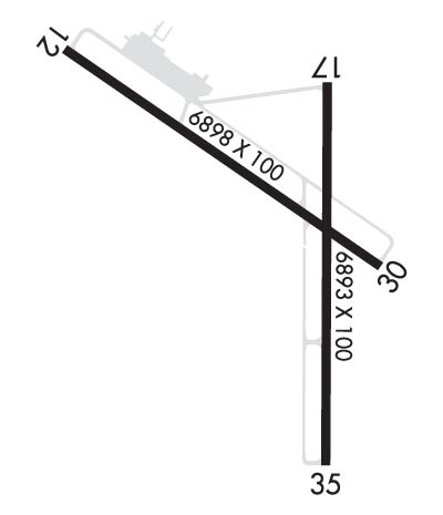
| Lat: N 4454.8 Long: W 09709.3 Elev: 1749 Var: -06 Longest Runway: 6898 | ||
| AWOS: 126.62 CTAF: 123.05 | ||
| ||||||||||||||||||||||||||||||||||||||||||||
| ||||||||||||||||||||||||||||||||||||||||||||
| ||||||||||||||||||||||||||||||||||||||||||||
| Rwy | Rwy | |||||||
| 6898x100 | 6898' | 6898x100 | 6898' | |||||
| 6893x100 | 6893' | 6893x100 | 6893' | 111.90 - 354° | ||||
| Runway ID | Single Wheel | Double Wheel | Double Tandem Wheel | Dual Double Wheel |
| 12/30 | 80,000 | 97,000 | 160,000 | N/A |
| 17/35 | 120,000 | 177,000 | 301,000 | N/A |
| These numbers are Advisory and are not limits. The Airport Manager should have more accurate Weight Limits | ||||
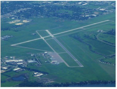
 Airport Diagram might not be current. | |
| Facility Name: | WATERTOWN RGNL |
| City Name: | WATERTOWN |
| County: | CODINGTON |
| State abbrev: | SD |
| State Name: | SOUTH DAKOTA |
| Ownership: | PUBLICLY OWNED |
| Use: | OPEN TO THE PUBLIC |
| Owner's Name: | CITY OF WATERTOWN |
| Address: | P.O. BOX 910 |
| WATERTOWN, SD 57201 | |
| Owner's Phone: | 605-882-6209 |
| Manager's Name: | IAN MERIWETHER-CHALFANT |
| Address: | 550 E AIRPORT DRIVE |
| WATERTOWN, SD 57201 | |
| Phone: | 605-753-9357; 605-753-9357 |
| FAA Region: | GREAT LAKES |
| FAA Field Office: | DMA |
| Date | Sunrise | Sunset |
|---|---|---|
| 05/07/26 Thursday | 6:10 | 20:41 |
| 05/08/26 Friday | 6:09 | 20:42 |
| 05/09/26 Saturday | 6:07 | 20:44 |
| 05/10/26 Sunday | 6:06 | 20:45 |
| 05/11/26 Monday | 6:05 | 20:46 |
| 05/12/26 Tuesday | 6:04 | 20:47 |
| 05/13/26 Wednesday | 6:02 | 20:48 |
| 05/14/26 Thursday | 6:01 | 20:49 |
| 05/15/26 Friday | 6:00 | 20:51 |
| 05/16/26 Saturday | 5:59 | 20:52 |
| 05/17/26 Sunday | 5:58 | 20:53 |
| 05/18/26 Monday | 5:57 | 20:54 |
| 05/19/26 Tuesday | 5:56 | 20:55 |
| 05/20/26 Wednesday | 5:55 | 20:56 |
| Airport Attendance Schedule | 7 Days A Week 0430-2030 |
| Airport Status | OPERATIONAL (This Status can change at any time - please check NOTAMS) |
| Airport Lighting Schedule | ACTVT MALSR RWY 35; PAPI RWY 12, 17, 30, & 35; HIRL RWY 17/35; MIRL RWY 12/30; REIL RWY 12, 17, & 30 - CTAF. |
| Airport Storage Available | Tie Downs, Hanger |
| Extra Services Available | Air Freight, Crop Dusting, Air Ambulance, Cargo Handling, Charter, Flight Instruction, Aircraft Rental, Aircraft Sales |
| Wind Indicator | YES - (lighted) |
| Control Tower | NO |
| CTAF Frequency | 123.050 |
| Unicom Frequency | 123.050 |
| Rotating Beacon Color | WG |
| Segmented Circle | YES |
| Landing Fee | YES |
| Airport Inspected | FEDERAL - performed by FAA AIRPORTS FIELD PERSONNEL |
| Inspection Date | 06/12/2024 |
| Type of Fuel Available | Grade 100LL, JET A (freeze point -40C) |
| Airframe Repair Service | MAJOR |
| Power Plant Repair Service | MAJOR |
| Latitude | N4454.8 |
| Longitude | W09709.3 (ESTIMATED) |
| Arpt Elevation | 1749ft (SURVEYED) |
| Magnetic Variation | 06E |
| 2 miles NW | of WATERTOWN |
| Traffic Pattern Altitude | |
| Sectional Chart | TWIN CITIES |
| Operations (Reported) | Yearly | Avg. Daily |
|---|---|---|
| General Aviation Transient | 0 | 0 |
| General Aviation Local | 0 | 0 |
| Air Taxi | 0 | 0 |
| Commerical | 0 | 0 |
| Commuter | 0 | 0 |
| Military | 0 | 0 |
| Aircraft based on Field | |
|---|---|
| General Aviation Singles | 0 |
| General Aviation Multi | 0 |
| Jet Aircraft | 0 |
| General Aviation Helicopters | 0 |
| Military Aircraft | 0 |
| Gliders | 0 |
| Ultralights | 0 |
| FSS on field | NO |
| FSS tie-in | HURON |
| FSS Phone | 1-800-WX-BRIEF |
| Who issues Notams | ATY |
| Notam D service at airport | YES |
| ARTCC Name | MINNEAPOLIS |
| Airport Certification | AIRPORT RECEIVING SCHEDULED AIR CARRIER SERVICE FROM CARRIERS CERTIFICATED BY THE CIVIL AERONAUTICS BOARD; PPR 48 HRS UNSKED ACR OPNS WITH MORE THAN 30 PSGR SEATS CALL AMGR 605 882-6209. |
| Aircraft Rescue & Firefighting Index | AIRPORT HAS A CERTIFICATE UNDER CFR PART 139 |
| Airport of Entry | No |
| Custom Landing Rights | No |
| Joint Civil/Military | No |
| Military Landing rights | YES |
| NATIONAL PLAN OF INTEGRATED AIRPORT SYSTEMS (NPIAS) |
| GRANT AGREEMENTS UNDER FAAP/ADAP/AIP |
| SURPLUS PROPERTY AGREEMENT UNDER PUBLIC LAW 289 |
| ASSURANCES PURSUANT TO TITLE VI, CIVIL RIGHTS ACT OF 1964 |
| GULLS & GEESE ON & INVOF ARPT APR-NOV. |
| GLIDER OPNS APR THRU SEP. |
| ANNUALLY APRIL- SEPT HAY CUTTING OPNS IN PROGRESS; FARMING EQUIP MAY BE IN APCHS. |
| ACR OPNS INVOLVING ACFT WITH MORE THAN 9 PSGRS ARE NOT AUZD IN EXCESS OF 15 MINS BEFORE OR AFTER SKED ARR/DEP TIMES WITHOUT PRIOR COORDINATION WITH AMGR AND CFMN THAT ARFF IS AVBL PRIOR TO LANDING OR TAKEOFF. |
| ARPT SFC COND NOT MONITORED 2230-0430. |
| FOR CD IF UNA TO CTC ON FSS FREQ, CTC MINNEAPOLIS ARTCC AT 651-463-5588. |
| RWY 12/3 0 PCR VALUE: 509/R/D/W/T |
| RWY 17/3 5 PCR VALUE: 491/R/D/W/T |
Airport Communications & Frequencies:
| |||||||||
| Runway: 12 | Runway: 30 | ||
| Mag heading: | 119° | Mag heading: | 299° |
| Rwy Slope: | -.23% Down | Rwy Slope: | .23% Up |
| Approach: | Approach: | ||
| Pattern: | Left Traffic | Pattern: | Left Traffic |
| Markings: | NONPRECISION INSTRUMENT | Markings: | NONPRECISION INSTRUMENT |
| Marking Condition: | GOOD | Marking Condition: | GOOD |
| Arresting Dev: | Arresting Dev: | ||
| Lat & Long: | N4455.3 W09710.2 | Lat. & Long.: | N4454.7 W09708.8 |
| Elev: | 1748.4 ft. MSL | Elev: | 1732.7 ft. MSL |
| TCH: | 48 ft. AGL | TCH: | 34 ft. AGL |
| Visual Glide Path: | 3.00 degrees | Visual Glide Path: | 3.00 degrees |
| Displaced Threshold: | No | Displaced Threshold: | No |
| Touchdown Zone: | YES | Touchdown Zone: | YES |
| Touchdown Elev.: | 1749.3 feet | Touchdown Elev.: | 1734.9 feet |
| Visual Glide Slope: | 4-Light PAPI on LEFT side of Runway | Visual Glide Slope: | 4-Light PAPI on LEFT side of Runway |
| RVR Equipment: | RVR Equipment: | ||
| RVV Equipment: | NO | RVV Equipment: | NO |
| Approach Lights: | Approach Lights: | ||
| REIL: | YES | REIL: | YES |
| Centerline Lights: | NO | Centerline Lights: | NO |
| Touchdown lights: | NO | Touchdown lights: | NO |
| Runway Category: | Runway with a Non-precision Approach having visibility minimums greater than 3/4 mile | Runway Category: | D |
| Declared Distances: | TORA:6899' TODA:6899' ASDA:6899' LDA:6899' | Declared Distances: | TORA:6899' TODA:6899' ASDA:6899' LDA:6899' |
| Obstructions: | Obstructions: | TREE | |
| Marked: | Marked: | NOT Marked/Lighted | |
| Clearance slope: | 34:1 | Clearance slope: | 35:1 |
| Obstruction height: | Obstruction height: | 51 feet AGL | |
| Dist. from runway: | Dist. from runway: | 2013 feet | |
| Centerline offset: | Centerline offset: | 329 feet left of centerline | |
| Comments: | Comments: |
| Runway: 17 | Runway: 35 | ||
| Mag heading: | 174° | Mag heading: | 354° |
| Rwy Slope: | .03% Up | Rwy Slope: | -.03% Down |
| Approach: | Approach: | ILS/DME | |
| Pattern: | Left Traffic | Pattern: | Left Traffic |
| Markings: | PRECISION INSTRUMENT | Markings: | PRECISION INSTRUMENT |
| Marking Condition: | GOOD | Marking Condition: | GOOD |
| Arresting Dev: | Arresting Dev: | ||
| Lat & Long: | N4455.2 W09709.1 | Lat. & Long.: | N4454.1 W09709.1 |
| Elev: | 1740.7 ft. MSL | Elev: | 1742.9 ft. MSL |
| TCH: | 35 ft. AGL | TCH: | 54 ft. AGL |
| Visual Glide Path: | 3.00 degrees | Visual Glide Path: | 3.00 degrees |
| Displaced Threshold: | No | Displaced Threshold: | No |
| Touchdown Zone: | YES | Touchdown Zone: | YES |
| Touchdown Elev.: | 1740.7 feet | Touchdown Elev.: | 1745.4 feet |
| Visual Glide Slope: | 4-Light PAPI on LEFT side of Runway | Visual Glide Slope: | 4-Light PAPI on LEFT side of Runway |
| RVR Equipment: | RVR Equipment: | ||
| RVV Equipment: | NO | RVV Equipment: | NO |
| Approach Lights: | Approach Lights: | MALSR - 1,400 foot medium intensity approach lighting system with runway alignment indicator lights | |
| REIL: | YES | REIL: | NO |
| Centerline Lights: | NO | Centerline Lights: | NO |
| Touchdown lights: | NO | Touchdown lights: | NO |
| Runway Category: | Runway with a Non-precision Approach having visibility minimums greater than 3/4 mile | Runway Category: | Precision Instrument Runway |
| Declared Distances: | TORA:6894' TODA:6894' ASDA:6894' LDA:6894' | Declared Distances: | TORA:6894' TODA:6894' ASDA:6894' LDA:6894' |
| Obstructions: | Obstructions: | BLDG | |
| Marked: | Marked: | LIGHTED | |
| Clearance slope: | 50:1 | Clearance slope: | 43:1 |
| Obstruction height: | Obstruction height: | 83 feet AGL | |
| Dist. from runway: | Dist. from runway: | 3775 feet | |
| Centerline offset: | Centerline offset: | 412 feet left of centerline | |
| Comments: | Comments: |
Thanks for using FltPlan.com
all rights reserved © 1999-2026 by Flight Plan LLC