| ANN ARBOR MUNI ANN ARBOR MI |
| |
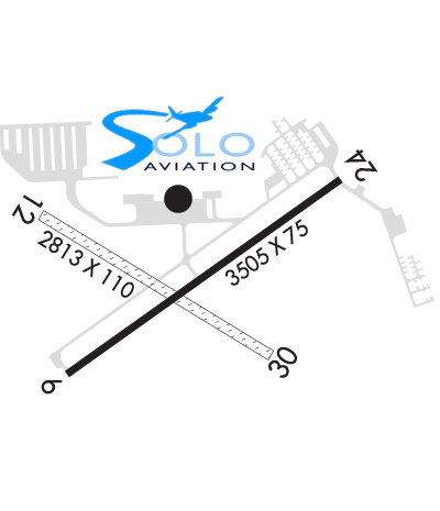
| Lat: N 4213.4 Long: W 08344.7 Elev: 839 Var: +05 Longest Runway: 3505 | ||
| Clr Del: 121.6 Dept. ATIS: 134.55 Arr. ATIS: 134.55 Ground: 121.6 Tower: 120.3 | ||
| |||||||||||||||||||||||||||||||||||||||||||||||||||||||||||||||||||||
| |||||||||||||||||||||||||||||||||||||||||||||||||||||||||||||||||||||
| |||||||||||||||||||||||||||||||||||||||||||||||||||||||||||||||||||||
| |||||||||||||||||||||||||||||||||||||||||||||||||||||||||||||||||||||
| Rwy | Rwy | |||||||
| 3505x75 | 3505' | 3505x75 | 3505' | |||||
| 2750x110 | 2750' | 2750x110 | 2750' | |||||
| Runway ID | Single Wheel | Double Wheel | Double Tandem Wheel | Dual Double Wheel |
| 06/24 | 45,000 | 70,000 | N/A | N/A |
| 12/30 | N/A | N/A | N/A | N/A |
| These numbers are Advisory and are not limits. The Airport Manager should have more accurate Weight Limits | ||||
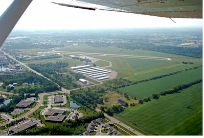
 Airport Diagram might not be current. | |
| Facility Name: | ANN ARBOR MUNI |
| City Name: | ANN ARBOR |
| County: | WASHTENAW |
| State abbrev: | MI |
| State Name: | MICHIGAN |
| Ownership: | PUBLICLY OWNED |
| Use: | OPEN TO THE PUBLIC |
| Owner's Name: | CITY OF ANN ARBOR |
| Address: | 301 E HURON ST, PO BOX 8647 |
| ANN ARBOR, MI 48107-8647 | |
| Owner's Phone: | 734-994-2841 |
| Manager's Name: | MATTHEW KULHANEK |
| Address: | 801 AIRPORT DR |
| ANN ARBOR, MI 48108-9703 | |
| Phone: | 734-994-9124 |
| FAA Region: | GREAT LAKES |
| FAA Field Office: | DET |
| Date | Sunrise | Sunset |
|---|---|---|
| 09/24/21 Friday | 7:24 | 19:29 |
| 09/25/21 Saturday | 7:25 | 19:27 |
| 09/26/21 Sunday | 7:26 | 19:26 |
| 09/27/21 Monday | 7:27 | 19:24 |
| 09/28/21 Tuesday | 7:28 | 19:22 |
| 09/29/21 Wednesday | 7:30 | 19:20 |
| 09/30/21 Thursday | 7:31 | 19:19 |
| 10/01/21 Friday | 7:32 | 19:17 |
| 10/02/21 Saturday | 7:33 | 19:15 |
| 10/03/21 Sunday | 7:34 | 19:13 |
| 10/04/21 Monday | 7:35 | 19:12 |
| 10/05/21 Tuesday | 7:36 | 19:10 |
| 10/06/21 Wednesday | 7:37 | 19:08 |
| 10/07/21 Thursday | 7:38 | 19:07 |
| Airport Attendance Schedule | APR-OCT 7 Days A Week 0800-2000, NOV-MAR 7 Days A Week 0800-1800; TERMINAL OPEN 0700-DUSK. |
| Airport Status | OPERATIONAL (This Status can change at any time - please check NOTAMS) |
| Airport Lighting Schedule | WHEN ATCT CLSD ACTVT MIRL RY 06/24, PAPI RY 06, VASI RY 24, AND REIL RY 06 - CTAF. |
| Airport Storage Available | Tie Downs, Hanger |
| Extra Services Available | Flight Instruction, Aircraft Rental, Glider Towing |
| Wind Indicator | YES - (lighted) |
| Control Tower | YES |
| CTAF Frequency | 120.300 |
| Unicom Frequency | 123.000 |
| Rotating Beacon Color | CLEAR-GREEN (Light Land Airport) |
| Segmented Circle | YES |
| Landing Fee |
| Airport Inspected | STATE - performed by STATE AERONAUTICAL PERSONNEL |
| Inspection Date | 10/31/2018 |
| Type of Fuel Available | Grade 100LL, JET A (freeze point -40C) |
| Airframe Repair Service | MAJOR |
| Power Plant Repair Service | MAJOR |
| Latitude | N4213.4 |
| Longitude | W08344.7 (ESTIMATED) |
| Arpt Elevation | 839ft (ESTIMATED) |
| Magnetic Variation | 05W |
| 3 miles S | of ANN ARBOR |
| Traffic Pattern Altitude | |
| Sectional Chart | DETROIT |
| Operations (Reported) | Yearly | Avg. Daily |
|---|---|---|
| General Aviation Transient | 23521 | 64 |
| General Aviation Local | 40000 | 110 |
| Air Taxi | 0 | 0 |
| Commerical | 0 | 0 |
| Commuter | 0 | 0 |
| Military | 0 | 0 |
| Aircraft based on Field | |
|---|---|
| General Aviation Singles | 141 |
| General Aviation Multi | 10 |
| Jet Aircraft | 1 |
| General Aviation Helicopters | 7 |
| Military Aircraft | 0 |
| Gliders | 1 |
| Ultralights | 0 |
| FSS on field | NO |
| FSS tie-in | LANSING |
| FSS Phone | 1-800-WX-BRIEF |
| Who issues Notams | ARB |
| Notam D service at airport | YES |
| ARTCC Name | CLEVELAND |
| Airport Certification | |
| Aircraft Rescue & Firefighting Index | None |
| Airport of Entry | No |
| Custom Landing Rights | No |
| Joint Civil/Military | No |
| Military Landing rights | YES |
| NATIONAL PLAN OF INTEGRATED AIRPORT SYSTEMS (NPIAS) |
| GRANT AGREEMENTS UNDER FAAP/ADAP/AIP |
| ASSURANCES PURSUANT TO TITLE VI, CIVIL RIGHTS ACT OF 1964 |
| DEER & BIRDS ON & INVOF ARPT. |
| WHEN ATCT CLSD CONFIRM SNOW REMOVAL OPNS & WINTER CONDS - CTAF. |
| RY 24 RUNUP AREA, FIRST 200 FT OF TWY A, & TWY AI BTN TWY A & RY 24 HOL LINE NOT VSB FM TWR. |
| NO SNOW REMOVAL FOR RY 12/30. |
| 24 HR RESTROOMS LCTD IN Q-ROW NW HNGRS. |
| FOR CD WHEN ATCT IS CLSD CTC DETROIT APCH AT 800-499-8181. |
Airport Communications & Frequencies:
| ||||||||||||||||||||||||
| Runway: 06 | Runway: 24 | ||
| Mag heading: | 60° | Mag heading: | 240° |
| Rwy Slope: | -.15% Down | Rwy Slope: | .15% Up |
| Approach: | Approach: | ||
| Pattern: | Left Traffic | Pattern: | Left Traffic |
| Markings: | NONPRECISION INSTRUMENT | Markings: | NONPRECISION INSTRUMENT |
| Marking Condition: | FAIR | Marking Condition: | FAIR |
| Arresting Dev: | Arresting Dev: | ||
| Lat & Long: | N4213.2 W08345.0 | Lat. & Long.: | N4213.5 W08344.4 |
| Elev: | 831.3 ft. MSL | Elev: | 826.0 ft. MSL |
| TCH: | 20 ft. AGL | TCH: | 20 ft. AGL |
| Visual Glide Path: | 3.00 degrees | Visual Glide Path: | 3.00 degrees |
| Displaced Threshold: | No | Displaced Threshold: | No |
| Touchdown Zone: | YES | Touchdown Zone: | YES |
| Touchdown Elev.: | 831.3 feet | Touchdown Elev.: | 830.7 feet |
| Visual Glide Slope: | 4-Light PAPI on LEFT side of Runway; PAPI UNUSABLE 7 DEGS LEFT & RIGHT OF COURSE. | Visual Glide Slope: | 2-Box VASI on LEFT side of Runway |
| RVR Equipment: | RVR Equipment: | ||
| RVV Equipment: | NO | RVV Equipment: | NO |
| Approach Lights: | Approach Lights: | ||
| REIL: | YES | REIL: | NO |
| Centerline Lights: | NO | Centerline Lights: | NO |
| Touchdown lights: | NO | Touchdown lights: | NO |
| Runway Category: | Runway with a Non-precision Approach | Runway Category: | Runway with a Non-precision Approach |
| Declared Distances: | Declared Distances: | ||
| Obstructions: | TREES | Obstructions: | ROAD |
| Marked: | NOT Marked/Lighted | Marked: | NOT Marked/Lighted |
| Clearance slope: | 50:1 | Clearance slope: | 25:1 |
| Obstruction height: | Obstruction height: | 15 feet AGL | |
| Dist. from runway: | Dist. from runway: | 580 feet | |
| Centerline offset: | Centerline offset: | ||
| Comments: | Comments: |
| Runway: 12 | Runway: 30 | ||
| Mag heading: | 127° | Mag heading: | 307° |
| Rwy Slope: | -.62% Down | Rwy Slope: | .62% Up |
| Approach: | Approach: | ||
| Pattern: | Left Traffic | Pattern: | Left Traffic |
| Markings: | Markings: | ||
| Marking Condition: | 12/30 MKD WITH 3 FT YELLOW CONES. | Marking Condition: | |
| Arresting Dev: | Arresting Dev: | ||
| Lat & Long: | N4213.5 W08345.1 | Lat. & Long.: | N4213.2 W08344.6 |
| Elev: | 839.0 ft. MSL | Elev: | 822.0 ft. MSL |
| TCH: | TCH: | ||
| Visual Glide Path: | Visual Glide Path: | ||
| Displaced Threshold: | No | Displaced Threshold: | No |
| Touchdown Zone: | YES | Touchdown Zone: | YES |
| Touchdown Elev.: | 839.0 feet | Touchdown Elev.: | 839.0 feet |
| Visual Glide Slope: | Visual Glide Slope: | ||
| RVR Equipment: | RVR Equipment: | ||
| RVV Equipment: | NO | RVV Equipment: | NO |
| Approach Lights: | Approach Lights: | ||
| REIL: | NO | REIL: | NO |
| Centerline Lights: | NO | Centerline Lights: | NO |
| Touchdown lights: | NO | Touchdown lights: | NO |
| Runway Category: | Runway with a Visual Approach | Runway Category: | Runway with a Visual Approach |
| Declared Distances: | Declared Distances: | ||
| Obstructions: | TREES | Obstructions: | TREES |
| Marked: | NOT Marked/Lighted | Marked: | NOT Marked/Lighted |
| Clearance slope: | 22:1 | Clearance slope: | 8:1 |
| Obstruction height: | 44 feet AGL | Obstruction height: | 60 feet AGL |
| Dist. from runway: | 990 feet | Dist. from runway: | 500 feet |
| Centerline offset: | Centerline offset: | 274 feet left of centerline | |
| Comments: | Comments: |
Thanks for using FltPlan.com
all rights reserved © 1999-2021 by Flight Plan LLC