
| SAN LUIS VALLEY RGNL/BERGMAN ALAMOSA CO |
| |
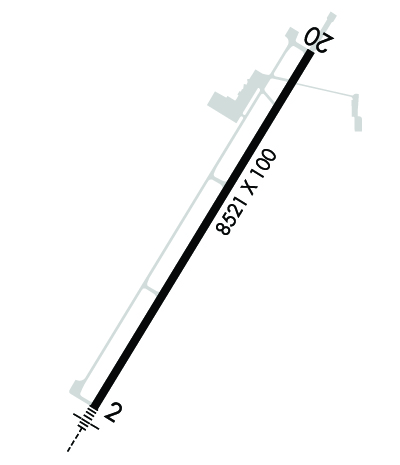
| Lat: N 3726.1 Long: W 10552.1 Elev: 7540 Var: -09 Longest Runway: 8521 | ||
| AWOS: 135.17 CTAF: 122.8 | ||
| ||||||||||||||||||||||||||||||||||||||||||||
| ||||||||||||||||||||||||||||||||||||||||||||
| Rwy | Rwy | |||||||
| 8521x100 | 8521' | 111.90 - 022° | 8521x100 | 8521' | ||||
| Runway ID | Single Wheel | Double Wheel | Double Tandem Wheel | Dual Double Wheel |
| 02/20 | 52,000 | 70,000 | N/A | N/A |
| These numbers are Advisory and are not limits. The Airport Manager should have more accurate Weight Limits | ||||
 Airport Diagram might not be current. | |
| Facility Name: | SAN LUIS VALLEY RGNL/BERGMAN FLD |
| City Name: | ALAMOSA |
| County: | ALAMOSA |
| State abbrev: | CO |
| State Name: | COLORADO |
| Ownership: | PUBLICLY OWNED |
| Use: | OPEN TO THE PUBLIC |
| Owner's Name: | CITY AND CO OF ALAMOSA |
| Address: | 2490 STATE AVE |
| ALAMOSA, CO 81101 | |
| Owner's Phone: | (719) 587-5211 |
| Manager's Name: | WILL HICKMAN |
| Address: | 2490 STATE AVE |
| ALAMOSA, CO 81101 | |
| Phone: | (719) 580-1986 |
| FAA Region: | NORTHWEST MOUNTAIN |
| FAA Field Office: | DEN |
| Date | Sunrise | Sunset |
|---|---|---|
| 09/24/21 Friday | 6:53 | 18:58 |
| 09/25/21 Saturday | 6:54 | 18:56 |
| 09/26/21 Sunday | 6:54 | 18:55 |
| 09/27/21 Monday | 6:55 | 18:53 |
| 09/28/21 Tuesday | 6:56 | 18:51 |
| 09/29/21 Wednesday | 6:57 | 18:50 |
| 09/30/21 Thursday | 6:58 | 18:48 |
| 10/01/21 Friday | 6:59 | 18:47 |
| 10/02/21 Saturday | 7:00 | 18:45 |
| 10/03/21 Sunday | 7:01 | 18:44 |
| 10/04/21 Monday | 7:01 | 18:42 |
| 10/05/21 Tuesday | 7:02 | 18:41 |
| 10/06/21 Wednesday | 7:03 | 18:39 |
| 10/07/21 Thursday | 7:04 | 18:38 |
| Airport Attendance Schedule | 7 Days A Week 0800-2000; FBO ON CALL 2001-0759 LCL, CALL 719-587-5335 |
| Airport Status | OPERATIONAL (This Status can change at any time - please check NOTAMS) |
| Airport Lighting Schedule | ACTVT MALSR RWY 02; REIL RWY 20; PAPI RWY 02; VASI RWY 20; HIRL RWY 02/20 - CTAF. |
| Airport Storage Available | Tie Downs, Hanger |
| Extra Services Available | Air Freight, Crop Dusting, Air Ambulance, Avionics, Charter, Flight Instruction, Aircraft Rental |
| Wind Indicator | YES - (lighted) |
| Control Tower | NO |
| CTAF Frequency | 122.800 |
| Unicom Frequency | 122.800 |
| Rotating Beacon Color | CLEAR-GREEN (Light Land Airport) |
| Segmented Circle | YES |
| Landing Fee | NO |
| Airport Inspected | FEDERAL - performed by FAA AIRPORTS FIELD PERSONNEL |
| Inspection Date | 10/22/2020 |
| Type of Fuel Available | Grade 100LL, JET A (freeze point -40C) |
| Airframe Repair Service | MAJOR |
| Power Plant Repair Service | MAJOR |
| Latitude | N3726.1 |
| Longitude | W10552.1 (ESTIMATED) |
| Arpt Elevation | 7539ft (SURVEYED) |
| Magnetic Variation | 09E |
| 2 miles S | of ALAMOSA |
| Traffic Pattern Altitude | |
| Sectional Chart | DENVER |
| Operations (Reported) | Yearly | Avg. Daily |
|---|---|---|
| General Aviation Transient | 3702 | 10 |
| General Aviation Local | 690 | 2 |
| Air Taxi | 2535 | 7 |
| Commerical | 0 | 0 |
| Commuter | 0 | 0 |
| Military | 1476 | 4 |
| Aircraft based on Field | |
|---|---|
| General Aviation Singles | 21 |
| General Aviation Multi | 7 |
| Jet Aircraft | 0 |
| General Aviation Helicopters | 0 |
| Military Aircraft | 0 |
| Gliders | 1 |
| Ultralights | 0 |
| FSS on field | NO |
| FSS tie-in | DENVER |
| FSS Phone | 1-800-WX-BRIEF |
| Who issues Notams | ALS |
| Notam D service at airport | YES |
| ARTCC Name | DENVER |
| Airport Certification | AIRPORT RECEIVING SCHEDULED AIR CARRIER SERVICE FROM CARRIERS CERTIFICATED BY THE CIVIL AERONAUTICS BOARD |
| Aircraft Rescue & Firefighting Index | AIRPORT HAS A CERTIFICATE UNDER CFR PART 139 |
| Airport of Entry | No |
| Custom Landing Rights | No |
| Joint Civil/Military | No |
| Military Landing rights | YES |
| NATIONAL PLAN OF INTEGRATED AIRPORT SYSTEMS (NPIAS) |
| GRANT AGREEMENTS UNDER FAAP/ADAP/AIP |
| ASSURANCES PURSUANT TO TITLE VI, CIVIL RIGHTS ACT OF 1964 |
| CONDS UNMON AT NGT AFT THE LAST ACR ARR TIL 0430L. SEE NOTAMS FOR THE MOST UP-TO-DATE CONDS. |
| FOR CD IF UNA TO CTC ON FSS FREQ, CTC DENVER ARTCC AT 303-651-4257. |
| PPR FOR UNSKED ACR OPNS WITH MORE THAN 30 PSGR SEATS. CALL ARPT OPS 719-298-7268. |
| ARFF COVERAGE PROVDD DRG ACR TFC OPS. FOR ARFF COVERAGE OUTSIDE OF ACR TIMES, CTC APRT OPNS FOR 24 HR PPR, 719-298-7268. |
| HOP ON & INVOF ARPT. |
Airport Communications & Frequencies:
| |||||||||
| Runway: 02 | Runway: 20 | ||
| Mag heading: | 23° | Mag heading: | 203° |
| Rwy Slope: | .00% Down | Rwy Slope: | .00% Up |
| Approach: | ILS | Approach: | |
| Pattern: | Left Traffic | Pattern: | Left Traffic |
| Markings: | PRECISION INSTRUMENT | Markings: | PRECISION INSTRUMENT |
| Marking Condition: | FAIR | Marking Condition: | FAIR |
| Arresting Dev: | Arresting Dev: | ||
| Lat & Long: | N3725.5 W10552.5 | Lat. & Long.: | N3726.7 W10551.6 |
| Elev: | 7539.5 ft. MSL | Elev: | 7539.3 ft. MSL |
| TCH: | 48 ft. AGL | TCH: | 41 ft. AGL |
| Visual Glide Path: | 3.00 degrees | Visual Glide Path: | 3.00 degrees |
| Displaced Threshold: | No | Displaced Threshold: | No |
| Touchdown Zone: | YES | Touchdown Zone: | YES |
| Touchdown Elev.: | 7539.5 feet | Touchdown Elev.: | 7539.8 feet |
| Visual Glide Slope: | 4-Light PAPI on LEFT side of Runway | Visual Glide Slope: | 4-BOX VASI ON LEFT SIDE OF RUNWAY |
| RVR Equipment: | RVR Equipment: | ||
| RVV Equipment: | NO | RVV Equipment: | NO |
| Approach Lights: | MALSR - 1,400 foot medium intensity approach lighting system with runway alignment indicator lights | Approach Lights: | |
| REIL: | NO | REIL: | YES |
| Centerline Lights: | NO | Centerline Lights: | NO |
| Touchdown lights: | NO | Touchdown lights: | NO |
| Runway Category: | Precision Instrument Runway | Runway Category: | Runway with a Non-precision Approach having visibility minimums greater than 3/4 mile |
| Declared Distances: | TORA:8519' TODA:8519' ASDA:8519' LDA:8519' | Declared Distances: | TORA:8519' TODA:8519' ASDA:8519' LDA:8519' |
| Obstructions: | Obstructions: | TREE | |
| Marked: | Marked: | NOT Marked/Lighted | |
| Clearance slope: | 50:1 | Clearance slope: | 27:1 |
| Obstruction height: | Obstruction height: | 40 feet AGL | |
| Dist. from runway: | Dist. from runway: | 1310 feet | |
| Centerline offset: | Centerline offset: | 15 feet right of centerline | |
| Comments: | Comments: |
Thanks for using FltPlan.com
all rights reserved © 1999-2021 by Flight Plan LLC
